

Mori Atlas logo
National parkBamingui-Bangoran National Park

Discover the mapped boundaries and diverse terrain of this extensive Central African national park.

Bamingui-Bangoran National Park: Protected Landscape and Geographic Atlas of the Central African Republic

(Bamingui-Bangoran National Park and Biosphere Reserve)

Bamingui-Bangoran National Park, a significant national park in the Central African Republic, offers a deep dive into its protected landscape identity. This atlas-focused exploration reveals the park's extensive savanna and tropical dry forest ecosystems, its position within the Guinea-Congo Forest biome, and its mapped geographic context. Understand the park's role as a vital conservation area and its unique natural terrain, providing a clear picture for geographic discovery and landscape analysis.

National ParkBiosphere ReserveTropical ForestSavanna EcosystemCentral AfricaGuinea-Congo Forest Biome

Bamingui-Bangoran National Park

National park

Park overview

Structured park overview, official facts, and landscape profile for Bamingui-Bangoran National Park

Bamingui-Bangoran National Park park facts, protected area profile, and essential visitor context

Review the core facts for Bamingui-Bangoran National Park, including designation, size, terrain, visitor scale, habitats, and operating context in one park-focused overview.

About Bamingui-Bangoran National Park

Bamingui-Bangoran National Park represents a flagship conservation area in the Central African Republic, spanning approximately 11,200 square kilometers in the country's north-central region. The park is situated west of the town of N'Délé and lies close to the border with Chad, forming part of a broader complex that includes the Vassako Bolo Strict Nature Reserve at its center. The landscape is characterized by a mixture of tropical dry deciduous forests, wooded savannas, and distinctive gallery forests that follow watercourses. The region's topography consists of a relatively flat plateau at elevations between 400 and 500 meters above sea level, with the park's waterways draining northwestward toward the Chari River. The Bamingui River's left bank floodplain is protected for a length of 202 kilometers, while 105 kilometers of the Bangoran River's floodplain receive protection status. The climate exhibits pronounced seasonality, with the rainy season lasting from May to October in southern areas and narrowing to June through September in the north, while humidity remains high throughout the year. The park's location within the Guinea-Congo Forest biome and the mid-Sudanian phytogeographic domain gives it substantial regional importance for biodiversity conservation. Compared to neighboring Manovo-Gounda St. Floris National Park, Bamingui-Bangoran holds higher density and greater numbers of wild animals, underscoring its ecological significance within the Central African protected area network.

Quick facts and research context for Bamingui-Bangoran National Park

Bamingui-Bangoran National Park covers roughly 11,200 square kilometers in the Central African Republic's northern region, making it one of the nation's largest protected areas. The park operates as both a national park under IUCN Category II and a UNESCO Biosphere Reserve. It lies within the mid-Sudanian phytogeographic zone at elevations of 400 to 500 meters, with the Bamingui and Bangoran Rivers providing key water resources that flow toward the Chari River system. The ecosystem comprises tropical dry forests, wooded savannas, edaphic savannas, and gallery forests characterized by tree species including Terminalia, Isoberlinia doka, and Anogeissus. The park was originally established in 1933 and received its current national park designation in 1993.

Protection and recognition

Mapping the official terrestrial designation and documented protection scope

Bamingui-Bangoran National Park Protection Status and Conservation Geography

Documented records trace the terrestrial protection scope and official conservation status established for Bamingui-Bangoran National Park. Accessing validated designation details helps researchers and conservationists understand the formal management framework of the regional landscape.

Protection details

Protection scope
Terrestrial
Park context

Deeper park guide and search-rich context for Bamingui-Bangoran National Park

Bamingui-Bangoran National Park history, landscape, wildlife, and travel context

Explore Bamingui-Bangoran National Park through its history, landscape character, ecosystems, wildlife, conservation priorities, cultural context, and seasonal travel timing in a structured park guide built for atlas discovery and search intent.

Why Bamingui-Bangoran National Park stands out

Bamingui-Bangoran is best known as a vast protected landscape within the Guinea-Congo Forest biome, representing one of the most extensive dry forest and savanna ecosystems in Central Africa. The park is distinguished by its significant populations of large mammals and its designation as an Important Bird Area by BirdLife International. It serves as a critical refuge for several vulnerable species including the Sudan cheetah, Central African African lion, and African manatee. The park also contains the Vassako Bolo Strict Nature Reserve at its core. Historically, the park was a stronghold for the Western Black Rhinoceros, though this species has been extinct in the country since 1986. The combination of diverse habitats ranging from dry forests to gallery forests and seasonal floodplains gives the park particular ecological significance for the Central African region.

Bamingui-Bangoran National Park history and protected-area timeline

Bamingui-Bangoran National Park traces its protected status to 1933, when the area was first established as a protected zone. The formal designation as a national park and biosphere reserve came in 1993, establishing the current institutional framework for the area's management and protection. For many years, the park operated as a relatively secure conservation area within the Central African Republic's northern region. However, this stability was disrupted in 2012 when Séléka rebels captured the park, leading to a significant decline in protection activities and increased pressure on the park's wildlife and ecosystems. Following this period of instability, conservation efforts resumed in 2018 when rangers employed by the Wildlife Conservation Society began patrolling the park. On December 18, 2018, park rangers engaged in a confrontation with rebels engaged in illegal hunting activities within the protected area. The engagement resulted in one rebel killed and three others fleeing, marking a significant moment in the ongoing effort to secure the park from illegal exploitation.

Bamingui-Bangoran National Park landscape and geographic character

The physical landscape of Bamingui-Bangoran National Park is defined by its position on a broad plateau in the Central African Republic's north-central region, with elevations ranging from 400 to 500 meters above sea level. The terrain is relatively flat and uniform, lacking dramatic topographical variation but offering extensive views across the savanna and forest mosaic. The park encompasses a network of important waterways, with the Bamingui River and Bangoran River being the primary watercourses. These rivers create seasonal floodplains that represent critical habitats within the broader savanna landscape. The Bamingui River's left bank floodplain is protected for approximately 202 kilometers, while the Bangoran River's protected floodplain extends for about 105 kilometers along its left bank. A smaller section of about 30 kilometers along the Bangoran River's right bank remains outside the formal protection framework. The waterways drain generally northwestward, ultimately reaching the Chari River system that flows into Lake Chad. The landscape supports a diverse mixture of habitat types including tropical dry forests, wooded savannas, edaphic savannas on specific soil types, and gallery forests that follow river corridors.

Bamingui-Bangoran National Park ecosystems, habitats, and plant life

The ecological character of Bamingui-Bangoran is defined by its position within the Guinea-Congo Forest biome and the mid-Sudanian phytogeographic domain. The park's major ecosystem is characterized as tropical dry or deciduous forest, with the primary habitats and land covers consisting of dry forests, wooded savannas, edaphic savannas, and gallery forests. The vegetation is characterized by tree species including Terminalia, Isoberlinia doka, and Anogeissus, which form the dominant canopy species across the different habitat types. The gallery forests that follow the river systems provide particularly important habitat corridors and moisture refuges within the broader savanna landscape. The seasonal flooding of the river floodplains creates dynamic wetland conditions that support distinct ecological communities. The park's location at the transition between forest and savanna ecosystems gives it particular significance for understanding ecological patterns in Central Africa. The presence of subspecific endemism in large mammals appears to be linked to Pleistocene isolation events associated with the Chari-Logone River system.

Bamingui-Bangoran National Park wildlife and species highlights

Bamingui-Bangoran National Park supports significant wildlife populations across its diverse habitats, though many species face conservation pressures. The park was historically a stronghold for the Western Black Rhinoceros in the Central African Republic, but this species has been extinct in the country since 1986. Several large mammal species of conservation concern are present, with the Chadian wild dog classified as endangered and the Sudan cheetah, Central African lion, and African manatee all classified as vulnerable. Antelope populations have declined markedly since 1960 according to documented studies. The park has been designated an Important Bird Area by BirdLife International due to its significance for bird populations, supporting significant populations of numerous species. The red-faced lovebird is among the notable bird species found in the park, with populations also occurring in Nigeria's Gashaka Gumti National Park. The amphibian fauna includes multiple species such as the Mascarene ridged frog, sharp-nosed ridged frog, Schilluk ridged frog, Galam white-lipped frog, cryptic sand frog, ornate frog, crowned bullfrog, flat-backed toad, shovelnose frog, Senegal kassina, and Natal puddle frog.

Bamingui-Bangoran National Park conservation status and protection priorities

Bamingui-Bangoran holds significant conservation importance as both a national park and a biosphere reserve within the Central African Republic's protected area network. The park's designation as an Important Bird Area by BirdLife International underscores its international significance for biodiversity conservation, particularly for bird species. The diverse habitat mosaic supporting forest, savanna, and wetland ecosystems provides refuge for multiple threatened species including the endangered Chadian wild dog and vulnerable Sudan cheetah, Central African lion, and African manatee. However, the park faces substantial ecological threats from foreign timber and mining concessions that operate in and around the protected area, as well as from poaching and agricultural land-clearance that drive habitat loss and species decline. The park's history reflects broader challenges facing conservation in post-conflict regions, with the 2012 Séléka rebel capture leading to significant declines in protection. The resumption of ranger patrols by the Wildlife Conservation Society in 2018 represents an important effort to restore conservation capacity, though the December 2018 clash with illegal hunters illustrates the ongoing security challenges facing the park.

Bamingui-Bangoran National Park cultural meaning and human context

Bamingui-Bangoran National Park is situated in the northern region of the Central African Republic, an area with limited documentation of indigenous communities within the immediate park boundaries. The park lies west of N'Délé, the principal town in the northern prefecture of Bamingui-Bangoran, and proximity to the Chad border gives the region strategic importance. The broader Central African Republic contains numerous ethnic groups with traditional relationships to the land, though specific indigenous communities associated with the park's interior are not prominently documented in available sources. The park's management involves international conservation partnerships, particularly with the Wildlife Conservation Society that supports ranger operations. The historical human presence in the region includes traditional land use patterns involving pastoralism and agriculture, though the park's protected status has restricted such activities within its boundaries.

Top sights and standout views in Bamingui-Bangoran National Park

Bamingui-Bangoran National Park stands as one of Central Africa's largest and most ecologically significant protected areas, spanning over 11,000 square kilometers of forest, savanna, and wetland habitats in the northern Central African Republic. The park's dual designation as a national park and UNESCO Biosphere Reserve reflects its international conservation importance, while its location within the Guinea-Congo Forest biome and designation as an Important Bird Area highlight its biodiversity significance. The combination of tropical dry forests, wooded savannas, and gallery forests along the Bamingui and Bangoran Rivers creates a diverse ecological landscape supporting numerous species, including vulnerable large mammals such as the Sudan cheetah and Central African lion. The park contains the Vassako Bolo Strict Nature Reserve at its core and holds higher animal density than neighboring Manovo-Gounda St. Floris National Park. Despite facing significant challenges from poaching, logging, and regional conflict, ongoing conservation efforts by the Wildlife Conservation Society continue working to protect this important ecosystem.

Best time to visit Bamingui-Bangoran National Park

Visiting Bamingui-Bangoran National Park is best during the dry season, which typically runs from November through April in the northern Central African Republic. During this period, wildlife becomes more concentrated around remaining water sources, making animal observation easier as vegetation thins and animals venture more openly into the savanna clearings. The cooler temperatures during the dry season also make outdoor activities more comfortable for visitors. The rainy season from May through September brings challenging travel conditions with muddy roads and reduced accessibility, though this period supports the park's lush green landscapes and provides optimal conditions for birdwatching when migratory species arrive. The park's remote location in northern CAR means that access requires careful planning and coordination with local authorities and conservation organizations. Visitors should be aware that the park has experienced security challenges in recent years, and current conditions should be verified with relevant authorities before planning any visit.
Monthly climate preview

Long-term temperature and precipitation patterns across the year

Bamingui-Bangoran National Park Climate Normals and Weather by Month

Representative coordinates record measured monthly temperature swings and shifting precipitation rates across the landscape. Reviewing complete monthly climate normals provides deeper context for long-term environmental patterns.
Annual mean27 °C
25 °C32 °C
Jan27°
Feb30°
Mar32°
Apr31°
May29°
Jun27°
Jul25°
Aug25°
Sep25°
Oct26°
Nov26°
Dec26°
Warmest month
March

31.6 °C

Coolest month
August

24.8 °C

Wettest month
August

8.1 mm/day

Driest month
January

0 mm/day

Park location guide

Geography guide, regional context, and park location map for Bamingui-Bangoran National Park

Bamingui-Bangoran National Park park geography, regions, and map view in Central African Republic

Understand where Bamingui-Bangoran National Park sits in Central African Republic through a broader geographic reading of the surrounding landscape, nearby location context, and its mapped position within the national park landscape.

How Bamingui-Bangoran National Park fits into Central African Republic

The Central African Republic is a landlocked nation in Central Africa with an area of approximately 622,984 km². It is bordered by six countries and features diverse terrain including Sudano-Guinean savanna in the central region, a Sahelo-Sudanian zone in the north, and equatorial forests in the south. Two-thirds of the country lies within the Ubangi River basin, while the remaining third is in the Chari River basin.

Wider geography shaping Bamingui-Bangoran National Park in Central African Republic

The Central African Republic occupies a vast landlocked territory in Central Africa. It shares borders with Chad to the north, Sudan to the northeast, South Sudan to the east, the Democratic Republic of the Congo to the south, the Republic of the Congo to the southwest, and Cameroon to the west. The terrain consists primarily of savanna, with the Ubangi River serving as a major waterway draining two-thirds of the country into the Congo River system.

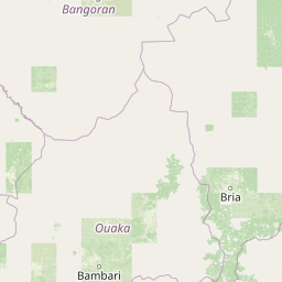
Map view of Bamingui-Bangoran National Park

Use this park location map to pinpoint Bamingui-Bangoran National Park in Central African Republic, understand its exact geographic position, and read its mapped placement within the surrounding landscape more clearly.

Pigeon | © OpenStreetMap contributors
Park atlas

Trace the regional geography and connected protected landscapes of Central Africa

Explore More National Parks and Protected Areas Near Bamingui-Bangoran National Park

Continue your exploration from Bamingui-Bangoran National Park by browsing additional protected areas and national parks across the Central African Republic and its neighboring regions. Compare the varied savanna ecosystems, tropical dry forests, and riverine protected landscapes to understand their regional conservation context and geographic spread.
National parkCentral African Republic
About 166 km away#1 closest

Northeast

St Floris National Park: Central African Republic's Expansive Protected Savanna Landscape

Discover its mapped boundaries and regional geographic context.

St Floris National Park, situated in the Central African Republic, is a vast protected savanna ecosystem vital for understanding regional geography and landscape conservation. This national park spans approximately 17,400 square kilometers, featuring diverse terrain from open grasslands to riverine woodlands and floodplains, critical for large mammal populations and birdlife. Its mapped extent and ecological significance make it a key entry in any atlas of protected areas, showcasing the challenges and importance of savanna conservation in Central Africa.

Area
17,400 km²
Established
1979
IUCN
II
Scope
Terrestrial
National parkChad
About 183 km away#2 closest

North

Aouk National Park National Park: Mapped Protected Landscape and Regional Geography

Explore Chad's Aouk National Park boundaries and terrain.

Investigate Aouk National Park, a significant national park in Chad, through its detailed mapping and protected landscape attributes. This entry provides insight into the park's geographic placement within Central Africa, emphasizing its role as a conservation area. Users can explore the mapped boundaries and regional geographic context, facilitating a structured understanding of this protected territory for atlas-based research and discovery.

Area
7,400 km²
IUCN
II
Access
Moderate access
Scope
Terrestrial
National parkGuéra Region
About 266 km away#3 closest

North

Zakouma National Park: Chad's Premier National Park and Protected Landscape

Explore the mapped savanna, acacia forests, and wildlife geography.

Zakouma National Park is Chad's oldest and most ecologically vital protected area, spanning 3,000 square kilometers of Sudano-Sahelian landscape. Situated within the Guéra Region, it is globally recognized for its exceptional Kordofan giraffe population, significant elephant recovery, and ongoing conservation successes, offering a unique view into African wildlife and protected area management.

Area
3,000 km²
Established
1963
IUCN
II
Relief
Lowland
National parkMoyen-Chari Region
About 281 km away#4 closest

Northwest

Manda National Park: National Park Protected Landscape and Geographic Identity in Moyen-Chari

Discover mapped terrain and regional context for this Chad national park.

Manda National Park, a protected natural area within Chad's Moyen-Chari Region, offers valuable insights into regional geography and mapped protected landscapes. This detail page provides focused information on the park's identity as a national park, emphasizing its geographic setting and the importance of its mapped boundaries for structured atlas exploration. Understand how this protected area contributes to the diverse natural terrain of the Moyen-Chari Region.

Area
1,140 km²
Established
1969
IUCN
II
Climate
Tropical
National parkChad
About 355 km away#5 closest

Northwest

Siniaka-Minia National Park: Discover its Protected Landscape and Geographic Context in Chad

Explore mapped park boundaries and regional natural landscapes.

Siniaka-Minia National Park stands as a protected national park within the vast geography of Chad, offering critical insights for atlas exploration. This entry details the park's protected landscape features and its contribution to the regional natural geography. Understand its mapped boundaries and its significance as a conservation area, providing valuable context for anyone exploring the protected lands of Central Africa.

Area
4,260 km²
Established
1965
IUCN
IV
Relief
Mixed relief
National parkCentral African Republic
About 371 km away#6 closest

Northeast

André Félix National Park National Park: Savanna Landscape Atlas & Protected Area

Central African Republic's protected lands geography.

André Félix National Park in the Central African Republic is an important protected area known for its expansive savanna terrain and its role in conserving significant populations of large African mammals, including elephants and giraffes. Established in 1960, this national park showcases the transitional Sudan-Guinea savanna ecosystem with diverse woodlands and riparian forests, offering a rich context for geographic exploration and understanding protected landscapes within Africa. Its mapped boundaries and natural features make it a key point of interest for atlas enthusiasts and conservation geography.

IUCN
II
Scope
Terrestrial
Water
No major water
National parkSudan
About 429 km away#7 closest

East

Radom National Park: A National Park in Sudan Offering Protected Landscape and Geographic Context

Explore mapped boundaries and regional terrain within Sudan.

Radom National Park is an important protected area designated as a national park in Sudan. This entry focuses on its specific geographic features and landscape characteristics, providing users with a detailed view of its mapped boundaries and regional context. Understanding Radom National Park's place within the atlas of African protected lands helps illuminate its natural terrain and conservation significance.

Area
12,509.7 km²
Established
1980
IUCN
II
Relief
Lowland
National parkSila Province
About 457 km away#8 closest

North

Goz Beïda National Park: National Park Protected Landscape and Geographic Context

Explore mapped boundaries and regional terrain.

Gain a structured understanding of Goz Beïda National Park, a key protected area within Sila Province. This detail page provides insights into its geographic setting, offering mapped landscape context for atlas-based discovery. Learn about the park's specific protected area identity and its position within the regional geography.

Area
3,000 km²
IUCN
II
Scope
Terrestrial
Water
No major water

Common questions about visiting, size, designation, and location context for Bamingui-Bangoran National Park

Bamingui-Bangoran National Park FAQs for park facts, access, geography, and protected area context

Find quick answers about Bamingui-Bangoran National Park, including protected-area facts, park geography, trail and visitor context, and how the park fits into its surrounding country and regional landscape.
MoriAtlas Explorer

Continue Your Protected Areas Search Across the Global Atlas

Deepen your exploration by continuing the structured search for national parks and protected areas worldwide. Utilize the comprehensive filtering capabilities to compare different conservation landscapes and refine your understanding of global park geography. Discover more about the distribution and characteristics of protected natural areas.

Global natural geography
