
Mori Atlas logo
Natural monumentBaradla Cave

A detailed atlas entry covering the extensive chamber architecture and limestone formations of this Hungarian natural monument.

Baradla Cave: Exploring the Subterranean Karst Landscapes and Geological Geography of Hungary

Baradla Cave stands as one of Central Europe's most significant subterranean karst systems, featuring an intricate network of galleries and limestone chambers that stretch through the Aggtelek Karst plateau. This protected natural monument provides a unique window into the karst development of the Pannonian Basin, where active river flows and immense stalactite formations continue to shape the interior landscape. The system acts as a conduit for subterranean water movement and remains a cornerstone for understanding the regional karst geology that defines this corner of Hungary.

karst landscapecave systemspeleothemsstalactitesstalagmitessubterranean river
A stylized, flat-design illustration of a waterfall falling between two steep, colorful cliffs surrounded by coniferous trees.

Baradla Cave

Natural monument

Park overview

Structured park overview, official facts, and landscape profile for Baradla Cave

Baradla Cave park facts, protected area profile, and essential visitor context

Review the core facts for Baradla Cave, including designation, size, terrain, visitor scale, habitats, and operating context in one park-focused overview.

About Baradla Cave

Baradla Cave is a defining natural landmark of the Aggtelek Karst in northern Hungary, a region of Triassic limestone where water has carved out one of the most extensive cave networks in Central Europe. The cave sits along Hungary's border with Slovakia, and its underground passages continue beneath that frontier, linking to the Domica Cave on the Slovak side. The combined Baradla-Domica system runs for more than 25 kilometers, making Baradla one of the longest decorated caves in the region.

The main entrance opens at Aggtelek, at the foot of a tall white cliff overlooking the village. From this point, an articulated, meandering main channel extends roughly 7 kilometers. For most of its length, this passage averages about 10 meters wide and 7 to 8 meters high, but it widens into enormous chambers, including a hall large enough to hold a thousand people at once. Short and long side branches branch off the main artery, and at times of flood a subterranean river flows through the principal passage.

What truly distinguishes Baradla, however, is the character of its interior decoration. Speleothems of many forms and colors line the cave walls and ceilings, and the system hosts what is widely cited as the world's tallest known stalagmite, reaching more than 37 meters. The variability of these formations reflects a complex geological history and gives the cave its reputation as an exceptional example of natural underground ornamentation.

Beyond its geological and aesthetic significance, Baradla is also an important ecological site. More than five hundred cave-dwelling species have been recorded in the system, including more than twenty bat species. The cave has therefore become a focus not just for tourism and speleology but also for broader conservation management of the karst region and its associated wetlands.

Quick facts and research context for Baradla Cave

Baradla Cave lies at the edge of Aggtelek village in northern Hungary, where its natural entrance opens at the foot of a high white cliff. It forms part of the Aggtelek Karst, a limestone region whose underground drainage has produced extensive and richly decorated cave systems.

The larger Baradla-Domica system extends more than 25.5 kilometers, with the Domica Cave contributing about 5.3 kilometers on the Slovak side. Baradla's main meandering passage runs roughly 7 kilometers and averages about 10 meters in width and 7 to 8 meters in height. The system is internationally protected as a UNESCO World Heritage Site and has been a center of speleological research and tourism since the early nineteenth century.

Protection and recognition

Documented terrestrial protection scope, designation year, and transboundary status records

Baradla Cave Protection Status and Designation History Overview

Baradla Cave maintains a documented terrestrial protection scope established in the year 1995 with active transboundary status. Official records compile the designation history and management framework associated with the protected area.

Protection details

Protection scope
Terrestrial
Designated year
1995
Transboundary protection
Yes
Park context

Deeper park guide and search-rich context for Baradla Cave

Baradla Cave history, landscape, wildlife, and travel context

Explore Baradla Cave through its history, landscape character, ecosystems, wildlife, conservation priorities, cultural context, and seasonal travel timing in a structured park guide built for atlas discovery and search intent.

Why Baradla Cave stands out

Baradla is most famous for the extraordinary variety and color of its speleothems, particularly the stalactites and stalagmites that decorate its main passage and side chambers. These formations, described as an unparalleled decorative spectacle, are the central identity of the cave. The system is also known for the world's tallest known stalagmite, rising roughly 37 meters within the cave, and for some of the largest individual caverns in Central Europe. Together with the Slovak Domica Cave, it provides a textbook example of how both tropical and temperate climatic phases have shaped a single karst landscape.
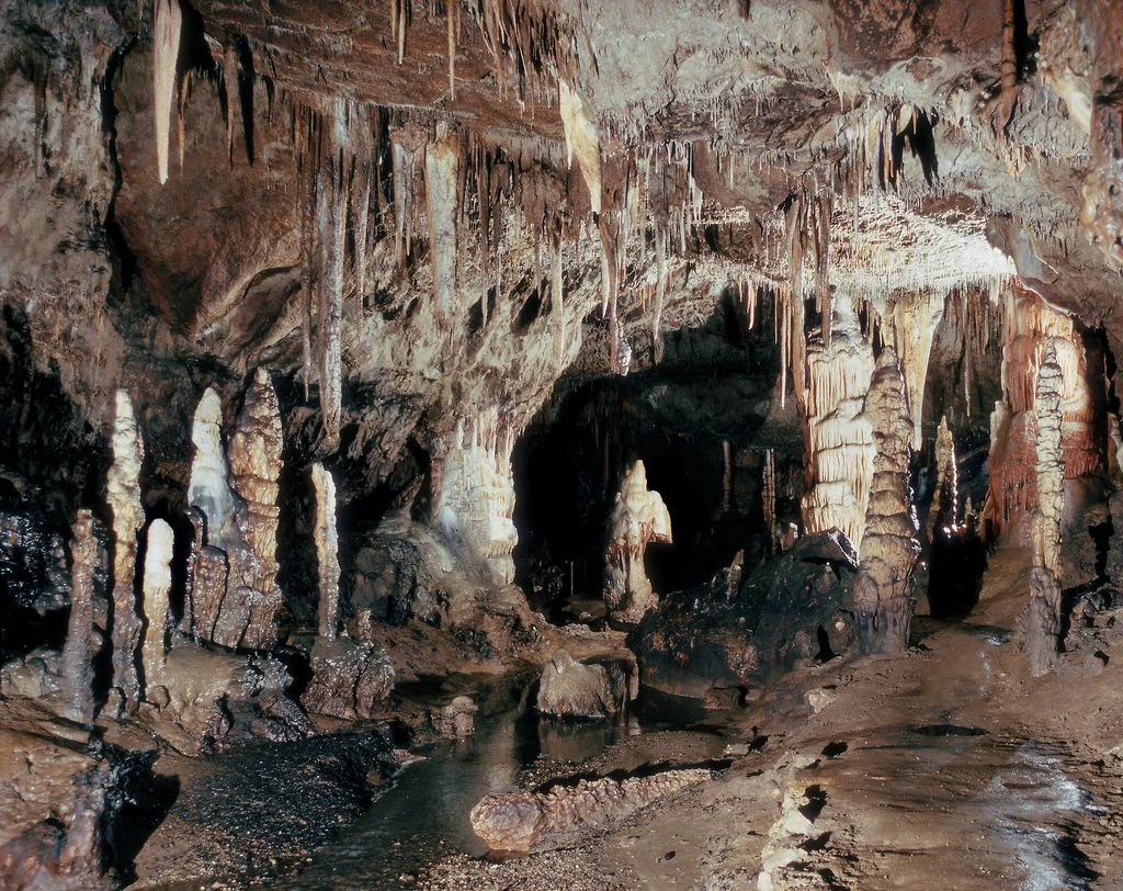
A cavern interior with numerous stalactites hanging from the ceiling and stalagmites rising from the floor, including a distinctive formation known as Minerva's Helmet.
The Minerva Helmet rock formation inside Baradla Cave, showcasing ornate karst formations.

Baradla Cave history and protected-area timeline

Baradla has been open to people since prehistoric times. Natural entrances made it accessible to early inhabitants, and traces of Neolithic occupation have been found near the cave, indicating that humans have known and used the system for thousands of years before written records began.

The first written mention of the cave dates from 1549, but systematic exploration began only in the modern era. In 1794 Joseph Sartory conducted the first survey, and in 1802 an initial map was produced. By 1825 only about 1.8 kilometers of the cave had been explored, but in that year the engineer Imre Vass pushed exploration about 5 kilometers farther along the main branch and published an accurate map and description in 1831 in both Hungarian and German.

To accommodate visitors, the first official tourist walkways were installed in 1806. The development of additional entrances, including the Red Lake entrances, came in 1890, and major extensions of the explored network were made in the late 1920s. In 1995 the cave was recognized as a UNESCO World Heritage Site alongside other caves of the Aggtelek and Slovak karst regions, and in 2001 the broader cave system and its catchment area, including important associated wetlands, were brought under formal protection. Baradla is now part of Aggtelek National Park and continues to be both a protected natural landmark and a popular visitor destination.

Baradla Cave landscape and geographic character

Above ground, the Baradla system is set within the rolling forested terrain of the Aggtelek Karst, a limestone plateau in northern Hungary where surface drainage has largely disappeared underground. The cave's natural entrance at Aggtelek is sited at the foot of an imposing white cliff that frames the edge of the village and signals the karst character of the region.

Beneath the surface, the landscape is defined by a long meandering main passage that winds through the limestone for about 7 kilometers. This tunnel averages roughly 10 meters wide and between 7 and 8 meters high, but includes enormous sections where the cave opens out into giant chambers. The system is heavily decorated with stalactites, stalagmites, draperies, and other speleothems in varied colors, with the world's tallest known stalagmite rising 37.2 meters from the cave floor.

The cave also acts as a conduit for a subterranean river. During floods, water flows along the main branch, reinforcing the impression of a still-active karst system constantly being reshaped by water. Together with the linked Domica Cave across the border in Slovakia, Baradla forms one of the most extensive and varied cave landscapes in the Carpathian region.

Baradla Cave ecosystems, habitats, and plant life

The Baradla system is ecologically significant primarily because it is a deep, stable cave environment that supports a rich community of cave-adapted fauna. The combination of large caverns, narrow side passages, stable temperatures, and surrounding forested karst creates varied microhabitats that have allowed a wide range of subterranean species to thrive.

The cave also intersects the broader surface ecology of the Aggtelek Karst through its bat populations and through the hydrological connections that feed wetlands above ground. The protection surrounding the system includes these surface catchment zones, emphasizing that the cave's ecological value is tied to the wider karst landscape rather than to the cave passages alone.

Because the ecosystem is dominated by species adapted to life in darkness, barrens of vegetation, and limited food input, the biological character of Baradla is very different from that of surface habitats. This makes it a notable site for the study and conservation of subterranean biodiversity in Central Europe.

Baradla Cave wildlife and species highlights

Baradla supports an unusually rich subterranean fauna for a Central European cave system. More than five hundred species of troglodytes, meaning cave-dwelling animals, have been recorded within the cave system as a whole.

Among the most visible and ecologically important groups are the bats. The system hosts twenty-one recorded bat species, making it a significant hibernation and roosting site in the region. These bat populations also link the cave to wider conservation concerns, since many of the species present depend on intact karst landscapes and undisturbed underground sites.

The wider cave fauna includes invertebrates and other small organisms adapted to the stable, dark environment of the passages. While less conspicuous than the formations, this biological community is a key reason why Baradla is treated as both a geological and an ecological conservation site.

Baradla Cave conservation status and protection priorities

Beyond its visual appeal, Baradla Cave is an internationally important conservation site. In 1995 it was inscribed as part of the Caves of Aggtelek Karst and Slovak Karst UNESCO World Heritage Site, recognized for its spectacular cave structures and for the rare evidence it preserves of both tropical and temperate climatic influences on karst development.

In 2001 formal protection was extended to the entire cave system and its catchment area, including internationally important wetlands near Domica. This step linked the conservation of the cave itself to the protection of the surrounding karst landscape and its hydrology, recognizing that the cave's integrity depends on the condition of the surface above it.

The cave is now managed within Aggtelek National Park, which provides ongoing protection for the geology, hydrology, and wildlife of the area. Aggtelek National Park serves both as a conservation framework and as an organized visitor destination, offering a range of hiking trails and guided cave experiences.

Baradla Cave cultural meaning and human context

Humans have interacted with Baradla for an extraordinarily long period. Traces of Neolithic occupation have been found near its natural entrances, suggesting that the cave was known and used thousands of years before the first written records. As a result, Baradla is part of the deep prehistory of the region, not merely a modern discovery.

From the sixteenth century onward the cave began to be documented in writing, and by the early nineteenth century it had become a destination for both scientific exploration and organized tourism. The installation of the first tourist walkways in 1806 places Baradla among the early show caves of Europe, and its nineteenth-century exploration by figures like Imre Vass established a tradition of detailed scientific study that continues today through the work of Aggtelek National Park.

Top sights and standout views in Baradla Cave

The highlights of Baradla Cave combine extreme scale, exceptional decoration, and international recognition. Its main passage runs roughly 7 kilometers and contains giant chambers, including a hall large enough to hold a thousand people at once. The cave's interior is rich with multicolored speleothems, and the system contains the world's tallest known stalagmite at 37.2 meters.

In addition to its geological features, Baradla is home to more than five hundred cave-dwelling species, including twenty-one bat species, and is part of a UNESCO World Heritage Site that protects both the cave and the connected wetlands. Managed within Aggtelek National Park, Baradla is one of the most impressive and accessible show caves in Central Europe.

Best time to visit Baradla Cave

As part of Aggtelek National Park, Baradla Cave can be visited throughout the year. The cave interior has a stable, cool climate that makes it a comfortable destination in summer, while its above-ground karst landscapes and associated forests have their own seasonal character, with the karst region appealing to visitors in both warm and cooler months. Specific visitor operations and seasonal schedules of the show cave are best confirmed locally with the national park administration.
Monthly climate preview

Long-term monthly temperature averages and precipitation records for Baradla Cave

Baradla Cave Climate Normals and Measured Annual Temperature Patterns

Historical climate data reveals a recorded annual temperature and precipitation rhythm across twelve measured coordinate points. Detailed monthly averages provide deeper context for studying long-term meteorological patterns at this location.
Annual mean9 °C
-4 °C20 °C
Jan-4°
Feb-2°
Mar
Apr
May15°
Jun19°
Jul20°
Aug20°
Sep15°
Oct
Nov
Dec-3°
Warmest month
July

20.5 °C

Coolest month
January

-4 °C

Wettest month
July

2.9 mm/day

Driest month
January

1.1 mm/day

Park location guide

Geography guide, regional context, and park location map for Baradla Cave

Baradla Cave park geography, regions, and map view in Hungary

Understand where Baradla Cave sits in Hungary through a broader geographic reading of the surrounding landscape, nearby location context, and its mapped position within the national park landscape.

How Baradla Cave fits into Hungary

Hungary is a landlocked Central European country occupying the Carpathian Basin, also known as the Pannonian Basin. It borders Slovakia, Ukraine, Romania, Serbia, Croatia, Slovenia, and Austria. Budapest serves as both the capital and largest city. The population is predominantly ethnic Hungarians (Magyars), with Hungarian as the official language.

Wider geography shaping Baradla Cave in Hungary

Hungary occupies the Carpathian Basin in Central Europe, a large lowland plain surrounded by the Carpathian Mountains. It is bordered by Slovakia to the north, Ukraine to the northeast, Romania to the east and southeast, Serbia to the south, Croatia and Slovenia to the southwest, and Austria to the west. The Danube River flows through the country, providing its primary drainage.

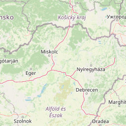
Map view of Baradla Cave

Use this park location map to pinpoint Baradla Cave in Hungary, understand its exact geographic position, and read its mapped placement within the surrounding landscape more clearly.

Pigeon | © OpenStreetMap contributors

Visual reference for subterranean chambers, limestone formations, and surface terrain

Baradla Cave Photos and Landscape Scenery in Aggtelek Karst

Baradla Cave photos reveal the extraordinary scale of massive subterranean chambers and multicolored speleothems across the Aggtelek Karst. Visual records of surface terrain and limestone formations help researchers evaluate the complex geomorphology of this protected landscape.

A cavern interior with numerous stalactites hanging from the ceiling and stalagmites rising from the floor, including a distinctive formation known as Minerva's Helmet.

A view inside a cavern showing large dripstone formations, stalactites, and stalagmites under warm artificial lighting, with the tops of people's heads visible at the bottom of the frame.

Park atlas

Compare adjacent subterranean networks and protected landscapes across regional boundaries.

Parks Near Baradla Cave and Protected Areas Across the Surrounding Karst Region

Browse national parks and protected areas located near Baradla Cave to examine connected karst formations and regional geography. Continuing beyond individual subterranean systems provides a broader perspective on surrounding protected landscapes.
Watercolor painting showing a winding river, green trees, distant hills, and grassy foreground
National parkHungary
Mapped location lies within the park boundary#1 closest

Northwest

Aggtelek National Park

Karst Landscape & Cave Systems

Explore the protected area of Aggtelek National Park, a UNESCO World Heritage site known for its extensive karst landscapes and significant cave systems. Understand its geographic setting and protected land status.

Area
198.92 km²
Established
1985
IUCN
II
Relief
Mixed relief
National parkKošice Region
About 1.3 km away#2 closest

North

Slovak Karst National Park: Premier Central European Karst Landscape and Cave Systems

Explore protected terrain and mapped underground wonders in Košice Region.

Slovak Karst National Park offers an unparalleled glimpse into a dynamic karst environment. As a designated national park and UNESCO Biosphere Reserve, it preserves a significant concentration of caves, dramatic limestone formations, and rugged canyons within its territory in southeastern Slovakia. This atlas-focused presentation highlights the park's distinctive geology, mapped landscape features, and its importance as a protected natural area within the broader geography of the Košice Region. Understand the park's surface topography and its world-renowned subterranean realms.

Area
346.11 km²
Established
2002
IUCN
II
Relief
Mountain
Watercolor painting showing a landscape with hills, a body of water, and vegetation
National parkBorsod-Abaúj-Zemplén County
About 34 km away#3 closest

South

Bükk National Park: Hungary's Largest National Park with Karst Terrain

Explore mapped boundaries and unique protected landscapes.

Bükk National Park, a protected national park located in Borsod-Abaúj-Zemplén County, Hungary, is recognized for its immense karst landscape. This park offers a significant focus for atlas exploration, with its extensive cave systems, limestone plateaus, and ancient forests providing a unique geographic context for understanding protected areas. Discover the diverse terrain and geological features that define this expansive Hungarian national park.

Area
431.3 km²
Established
1977
IUCN
II
Relief
Mixed relief
Watercolor illustration of a winding river through rolling green hills with trees in the foreground
National parkKošice Region
About 43 km away#4 closest

North

Slovak Paradise National Park: Protected Area Mapping & Geographic Context in Košice Region

Explore the boundaries and terrain of this national park.

Investigate Slovak Paradise National Park, a designated national park situated within Slovakia's Košice Region. This detailed entry provides essential context for understanding its protected landscape features, mapped geographic distribution, and role within regional atlas exploration. Discover its unique terrain and boundaries to build a comprehensive view of Slovak conservation areas.

Area
197.63 km²
Established
1988
IUCN
II
Relief
Mountain
Watercolor illustration of a forested landscape with mountains, trees, and a river
National parkBanská Bystrica Region
About 44 km away#5 closest

Northwest

Muránska planina National Park: Discover Slovakia's Karst Plateau and Protected Natural Landscape

Explore mapped boundaries, caves, and endemic flora in Banská Bystrica Region.

Muránska planina National Park represents a significant protected landscape in central Slovakia's Banská Bystrica Region, defined by its extensive karst topography. This national park encompasses a limestone and dolomite plateau rich with geological wonders, including over 150 caves, sinkholes, and karst springs. The unique contrast between the flat plateau surface and the sharp, rocky ravines showcases a dramatic natural terrain. Explore the park's mapped boundaries and its remarkable biodiversity, highlighted by 35 endemic species and rare Tertiary relict flora like Daphne arbuscula, making it a key destination for atlas-based geographic discovery.

Area
213.18 km²
Established
1997
IUCN
II
Relief
Mountain
Watercolor painting of rolling mountains in green, yellow, and pink tones
National parkSlovakia
About 48 km away#6 closest

Northwest

Low Tatras National Park: Slovakia's Vast National Park and Carpathian Protected Landscape

Explore mapped terrain and regional geographic context.

The Low Tatras National Park represents Slovakia's largest protected area, encompassing the entirety of the Low Tatras mountain range. Its landscape is defined by dramatic altitudinal diversity, from alpine summits like Ďumbier to extensive forest zones and significant karst formations with notable cave systems. This page provides detailed geographic context and map-based discovery for the park's protected boundaries and its ecological significance within the Carpathian region.

Area
728 km²
Established
1978
IUCN
II
Relief
Mountain
Watercolor painting showing a lake surrounded by trees and mountains in the background
National parkSlovakia
About 73 km away#7 closest

Northwest

Tatra National Park: Mapping the Alpine Peaks and Glacial Landscapes of Slovakia

Protected Mountain Terrain in the Carpathian Range

Examine the geographic framework of Tatra National Park, a significant protected area in Slovakia defined by dramatic glacial valleys, over three hundred caves, and high-altitude mountain ecosystems. This authoritative entry provides a detailed look at the park's alpine boundaries, hydrological networks, and role as a transboundary biosphere reserve in the Carpathian Mountains.

Area
738 km²
Established
1949
IUCN
II
Relief
Mountain
Watercolor painting depicting grasslands, hills, and a body of water.
National parkHungary
About 82 km away#8 closest

Southeast

Hortobágy National Park: A UNESCO Protected Steppe Landscape in Eastern Hungary

Explore the unique geography and mapped park boundaries of Hungary's first national park.

Hortobágy National Park is a monumental protected area in Eastern Hungary, recognized globally as the first national park established in the country and a UNESCO World Heritage site. This vast expanse of semi-natural grassland, known as the puszta, stretches across approximately 74,820 hectares, embodying over four millennia of pastoral traditions. The park's landscape is characterized by alkaline soils and sweeping horizons, offering a unique ecosystem with significant avian populations and preserved cultural landmarks. MoriAtlas provides structured geographic context and mapped details to understand this exceptional protected landscape.

Area
748.2 km²
Established
1973
IUCN
II
Relief
Lowland

Common questions about visiting, size, designation, and location context for Baradla Cave

Baradla Cave FAQs for park facts, access, geography, and protected area context

Find quick answers about Baradla Cave, including protected-area facts, park geography, trail and visitor context, and how the park fits into its surrounding country and regional landscape.
MoriAtlas Explorer

Continue Your Protected Areas Search Across the Global Atlas

Deepen your exploration by continuing the structured search for national parks and protected areas worldwide. Utilize the comprehensive filtering capabilities to compare different conservation landscapes and refine your understanding of global park geography. Discover more about the distribution and characteristics of protected natural areas.

Global natural geography