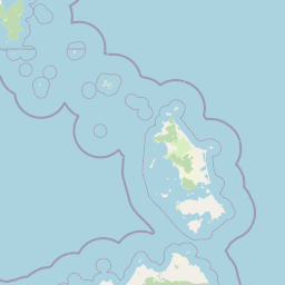
Why Beagle Commonwealth Marine Reserve stands out
The reserve is best known for protecting an expanse of shallow continental shelf seabed in Bass Strait, an area whose submarine landscape represents the drowned Bassian Plain that once connected Tasmania to the mainland around the last ice age. Its boundaries wrap around Kent Group National Park and the Hogan and Curtis island groups, making it a marine counterpart to some of Victoria and Tasmania's most distinctive coastal island parks. The reserve is also notable for the historical shipwrecks lying on its seafloor, including Second World War-era losses that contribute to its maritime heritage character.
Beagle Commonwealth Marine Reserve history and protected-area timeline
Beagle Commonwealth Marine Reserve was formally established on 31 August 2007 as part of the development of Australia's national system of Commonwealth marine reserves. Its creation reflected growing recognition of Bass Strait as a marine environment of national significance, sitting between the southern Victorian coast and the waters around northern Tasmania.
The reserve was later integrated into the South-east Commonwealth Marine Reserve Network, an initiative designed to ensure that representative examples of Australia's temperate south-east marine ecosystems receive coordinated conservation protection. Its administration was assigned to Parks Australia, the division of the Commonwealth Director of National Parks responsible for managing Commonwealth-protected natural and cultural environments.
The waters and seabed that the reserve protects carry a long natural history reaching back to a time when the area was dry land. During the last ice age, the region formed part of the Bassian Plain, a land bridge that joined Tasmania to mainland Australia. As the climate warmed and sea levels rose, this landscape was progressively flooded, leaving a shallow shelf that has since accumulated its own ecological and human history, including losses such as the SS Cambridge to a Second World War mine.
Beagle Commonwealth Marine Reserve landscape and geographic character
Although entirely underwater, the landscape of Beagle Commonwealth Marine Reserve is the dominant feature of its identity. The reserve encompasses a broad area of the Bass Strait continental shelf, where the seabed lies in relatively shallow water, typically between about 50 and 70 metres in depth. This shallow seafloor forms a continuation of the broader Bassian shelf system that links southern Victoria to the northern waters of Tasmania.
The broader landscape context surrounding the reserve is striking. To the north-east lies Wilson's Promontory, the southernmost tip of mainland Australia, a region of craggy headlands, granite peaks, and turquoise bays that defines the nearby shoreline. To the south and south-east, the waters overlap with the island archipelagos of Kent Group, Hogan Group, and Curtis Group, each made up of small, rugged islands fringed by reefs and exposed to the windy conditions of Bass Strait. Together, these islands and headlands frame the reserve as a marine space nested within one of Australia's most visually distinctive temperate coastal regions.
The seafloor's deep-time history is equally important to its landscape character. The submerged terrain preserves the flat profile of the ancient Bassian Plain, a low, open landscape that, during glacial periods, supported terrestrial ecosystems far different from today's marine environment. The transition from dry land to shallow sea continues to shape how the reserve's underwater landscape functions ecologically, with sediment patterns, reef formations, and water movement all reflecting its origins as a drowned land bridge.
Beagle Commonwealth Marine Reserve ecosystems, habitats, and plant life
The marine environment protected within Beagle Commonwealth Marine Reserve is characteristic of the temperate, shallow continental shelf waters of south-eastern Australia. The seabed supports a mix of benthic habitats shaped by soft sediments, reef structures, and the variable conditions of Bass Strait, including strong tidal flows and seasonal shifts in temperature and productivity. These habitats are typical of the transition zone between the cool waters of the Southern Ocean and the more sheltered embayments of southern Victoria and northern Tasmania.
Because the reserve sits within and around island groups such as Kent, Hogan, and Curtis, its ecological character is closely linked to the surrounding coastline. The islands contribute nutrients and shelter to the marine environment, while the surrounding waters support a mosaic of reef, sand, and sediment habitats. Such areas are typically important for sustaining fish populations, invertebrates, and the broader food web of the Bass Strait region, although specific communities vary across the reserve depending on depth, substrate, and exposure to currents.
The ecological context of the reserve is also shaped by its history as a former land bridge. The relatively flat and shallow seabed left behind by the Bassian Plain influences how water circulates and how habitats are distributed today. The reserve's placement within the South-east Commonwealth Marine Reserve Network reflects its role as a representative stretch of this shelf ecosystem, helping ensure that the temperate marine environments of south-eastern Australia are maintained in a connected, resilient state.
Beagle Commonwealth Marine Reserve wildlife and species highlights
Beagle Commonwealth Marine Reserve protects wildlife assemblages typical of the shallow, productive waters of Bass Strait. These environments are known to support diverse fish communities, marine invertebrates, and the broader food webs that connect seabed habitats to open-water and shoreline ecosystems. The reserve's waters around the Kent, Hogan, and Curtis island groups are particularly influenced by the interaction between island coastlines and the open shelf, creating conditions favourable to a range of reef-associated and pelagic species.
Although detailed inventories for the reserve are limited in publicly available sources, the broader Bass Strait region is recognised for its importance to seabirds, marine mammals, and migratory species that move through the strait. The reserve's position between Victoria and Tasmania means it lies along natural pathways for species moving between the two landmasses and the open Southern Ocean, while nearby islands provide nesting and haul-out sites that complement the marine protections of the reserve itself.
Beagle Commonwealth Marine Reserve conservation status and protection priorities
The primary conservation value of Beagle Commonwealth Marine Reserve lies in its protection of a representative section of the Bass Strait continental shelf, a marine environment recognised as part of Australia's broader temperate south-east ecosystem. By placing roughly 2,928 square kilometres of shallow shelf waters under Commonwealth protection, the reserve contributes to safeguarding habitat continuity in a region where coastal development, fishing, and shipping all exert pressure on the marine environment.
The reserve's IUCN Category VI classification acknowledges both its conservation role and its continued allowance of certain human activities. By zoning the entire area as Multiple Use, the reserve balances ecological protection with sustainable use, permitting recreational fishing while requiring approval for more impactful activities such as commercial fishing and seabed mining. This approach reflects an intent to maintain ecosystem functions while allowing compatible human activity under regulation.
Its inclusion in the South-east Commonwealth Marine Reserve Network strengthens these conservation outcomes by linking the reserve with other marine protected areas nearby. Together, these reserves form a more connected conservation estate that supports ecological processes such as species movement and larval dispersal across the shelf, helping to maintain the long-term resilience of Bass Strait's marine environment.
Beagle Commonwealth Marine Reserve cultural meaning and human context
The cultural context of the Beagle Commonwealth Marine Reserve is shaped primarily by its maritime heritage rather than by onshore settlement. The waters of Bass Strait have long been traversed by vessels traveling between southern Victoria, northern Tasmania, and the islands scattered across the strait, weaving the area into a long history of seafaring, trade, and navigation.
This maritime history is most visibly expressed through the shipwrecks lying within or near the reserve. The wreck of the SS Cambridge, sunk during the Second World War by a German mine, and other lost vessels such as the Eliza Davis, contribute an important heritage dimension to the reserve. These wrecks are part of the broader narrative of Bass Strait as a challenging and sometimes perilous waterway, and they add a cultural-historical layer to an area whose modern identity is otherwise defined by natural and ecological values.
While deeper indigenous or community-level histories of the islands and waters covered by the reserve are not strongly represented in the available source material, the islands and coastline surrounding the reserve have long-standing human and cultural associations that complement its natural heritage.
Top sights and standout views in Beagle Commonwealth Marine Reserve
Among the reserve's most defining highlights is the sheer extent and depth range of the marine area it protects, encompassing approximately 2,928 square kilometres of shallow continental shelf in Bass Strait at typical depths of 50 to 70 metres. Its boundaries meaningfully connect the reserve to protected island estates, enclosing Kent Group National Park and spanning the adjacent Hogan and Curtis island groups.
Another standout feature is the reserve's geological story: the seabed represents the drowned Bassian Plain, a former land bridge that linked Tasmania and mainland Australia during the last ice age. The reserve's classification as an IUCN Category VI Multiple Use zone, with recreational fishing allowed but commercial fishing and mining strictly controlled, also distinguishes it among Australian Commonwealth marine reserves. Together with its wartime shipwrecks, these features give the reserve a layered identity that blends marine conservation, deep-time landscape history, and maritime cultural heritage.
Best time to visit Beagle Commonwealth Marine Reserve
Given the marine nature of the reserve, any visit is shaped by the prevailing conditions of Bass Strait rather than traditional terrestrial seasons. The region experiences cooler temperatures and stronger winds through winter, while summer months generally bring calmer seas, warmer water, and longer daylight hours, conditions that are more favourable for boat-based excursions, scenic cruising, and viewing the surrounding islands and coastlines from nearby shores.
Wildlife observation and visibility conditions can also vary seasonally, with productive marine life often tied to broader patterns in temperate southern Australian waters. For visitors approaching the reserve from nearby areas such as Wilson's Promontory or Flinders Island, planning around the milder and more stable conditions of the warmer months will typically offer a more rewarding experience of the surrounding marine and island landscapes.