
Mori Atlas logo
Nature reserveBinnenveld

Mapping the rare blue grasslands and stream valley bog habitats of the Gelderse Vallei

Binnenveld Nature Reserve: A Protected Wetland Landscape in the Heart of Gelderland, Netherlands

Binnenveld serves as a critical protected wetland, spanning the Gelderse Vallei between Wageningen and Veenendaal. This lowland polder landscape preserves one of the largest contiguous areas of blue grassland in the Netherlands alongside rare quaking bog habitats fed by calcareous seepage water. The region offers a distinct geographic contrast where flat meadowland meets the forested ridges of the Utrechtse Heuvelrug.

nature reserveNatura 2000wetlandblue grasslandquaking bogmeadowland
A flat vector-style illustration of a river flowing through a lush mountain valley with steep cliffs, a waterfall, and coniferous forest.

Binnenveld

Nature reserve

Park overview

Structured park overview, official facts, and landscape profile for Binnenveld

Binnenveld park facts, protected area profile, and essential visitor context

Review the core facts for Binnenveld, including designation, size, terrain, visitor scale, habitats, and operating context in one park-focused overview.

About Binnenveld

Binnenveld is a defining element of the southern Gelderse Vallei, an elongated lowland basin between the higher, forested push moraines of the Veluwe to the northeast and the Utrechtse Heuvelrug to the southwest. Within this basin, Binnenveld occupies the stretch of open, traditionally managed meadowland that runs between Wageningen, Bennekom, Ede, Veenendaal, and Rhenen, with the wooded slopes of the Grebbeberg forming a clear southwestern boundary.

Although the wider Binnenveld is a working agricultural landscape, marked by long straight roads and a history of drainage and reclamation going back to the late Middle Ages, it also contains ecologically exceptional pockets where ancient, base-rich seepage still feeds the soil. These conditions have allowed extraordinary habitat types to persist: the nutrient-poor but mineral-rich blue grasslands of the Bennekomse Meent, and the floating, spongy quaking bogs of the Hel and Blauwe Hel, both fed by groundwater that has traveled from the surrounding higher ground.

Around these protected reserves, the landscape continues to evolve. Large former agricultural parcels near the Veensteeg and the Grift have been excavated and converted into wet hay meadows, creating new nature areas such as the Binnenveldse Hooilanden in Gelderland and the Achterbergse Hooilanden in Utrecht. Together with the existing Natura 2000 reserves, these restored grasslands link Binnenveld into the broader Natuurnetwerk Nederland, strengthening its role as a refuge for meadow birds, marsh flora, and other species that depend on a continuity of wet, open countryside.

Quick facts and research context for Binnenveld

Binnenveld is a Dutch Natura 2000 site (area number 65) covering roughly 111 hectares east of Veenendaal in the southern Gelderse Vallei. It lies on the boundary between the provinces of Gelderland and Utrecht, framed by Wageningen, Bennekom, Ede, Veenendaal, and Rhenen, and bordered on the southwest by the Grebbeberg, part of the Utrechtse Heuvelrug push moraine. The protected area consists of two nature reserves: the Bennekomse Meent, a blue-grassland reserve of national significance, and the Hel / Blauwe Hel, a stream-valley reserve containing rare quaking bog vegetation fed by base-rich groundwater seepage. The broader Binnenveld region also functions as a recognized meadow-bird area and quiet zone, with ongoing restoration of former farmland into wet hay-meadow nature reserves.

Protection and recognition

Documented protection records and formal conservation establishment details for Binnenveld

Binnenveld Protection Status and Designated Terrestrial Conservation History

Binnenveld maintains a documented terrestrial protection status established in the year 2014 through official administrative frameworks. Conservation records outline the registered designation timeline and management scope without additional international recognition sources.

Protection details

Protection scope
Terrestrial
Designated year
2014
Transboundary protection
No
Park context

Deeper park guide and search-rich context for Binnenveld

Binnenveld history, landscape, wildlife, and travel context

Explore Binnenveld through its history, landscape character, ecosystems, wildlife, conservation priorities, cultural context, and seasonal travel timing in a structured park guide built for atlas discovery and search intent.

Why Binnenveld stands out

Binnenveld is best known for hosting one of the largest continuous areas of blue grassland in the Netherlands, together with a nationally rare example of a stream-valley quaking bog sustained by calcareous seepage water. These two habitats, protected within the Natura 2000 site, give the area an ecological significance far beyond its modest size, placing Binnenveld among the most important surviving lowland wet-grassland landscapes in the country.
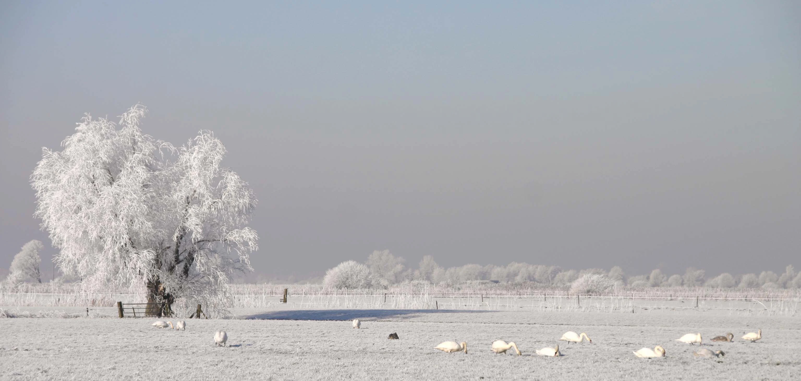
A wide, flat field covered in frost with a large, frosted tree on the left and a flock of white birds resting in the snow in the distance.
A winter scene in the Binnenveld nature reserve featuring frost-covered trees and a flock of birds resting on snow-dusted grasslands.

Binnenveld history and protected-area timeline

The Binnenveld landscape has its roots in the late Middle Ages, when the natural peat and wet-meadow environment of the southern Gelderse Vallei was reclaimed, drained, and reorganized into a field pattern still visible today in its long, straight roads and rectangular parcel layout. The southern part of the area sits on clay-over-peat soils, while the western portion originally consisted of raised bog that was also reclaimed after the medieval period; the peat-cutting and settlement that followed this reclamation gave rise to the town of Veenendaal.

For centuries the reclaimed land has been used primarily as meadow, supporting dairy farming and the traditional hay harvest typical of the Gelderse Vallei. Although much of this cultural landscape has been simplified by modern agriculture, fragments of older, species-rich grassland survived in low-lying areas where groundwater conditions were too difficult to drain completely, and these fragments eventually became the basis for modern nature conservation.

In the early twenty-first century, Binnenveld entered a new phase of active restoration. In 2014, approximately 111 hectares east of Veenendaal were formally designated as a Natura 2000 site under the name Binnenveld (formerly the Bennekomse Meent). Beginning around 2019, the provinces of Gelderland and Utrecht, together with Staatsbosbeheer and local partners, set in motion a long-term plan to improve recreational access and to reconstruct lost landscape features, including the remediation of former landfill sites and the large-scale conversion of former farmland into hay-meadow nature reserves.

Binnenveld landscape and geographic character

Binnenveld lies at the bottom of a wide, flat valley, where the flatness of centuries-old meadow polders contrasts sharply with the wooded ridges that frame the area. To the southwest rises the Grebbeberg, the northern spur of the Utrechtse Heuvelrug, with its forested slopes forming a green backdrop to the otherwise open plain. The Valleikanaal and the Nieuwe Kanaal cut through the landscape near Wageningen, while the Grift and other small historical waterways continue to shape drainage patterns and field boundaries.

The soils reflect the area's transition between two landscapes. In the south, clay-over-peat profiles dominate, the legacy of an ancient peatland that once stretched across the valley. In the west, the original raised-bog peat has long since been cut and settled, giving rise to Veenendaal and to a slightly different agricultural mosaic. Where modern drainage has not been complete, low-lying parcels remain wet year-round, and these are the places where the most distinctive vegetation still survives.
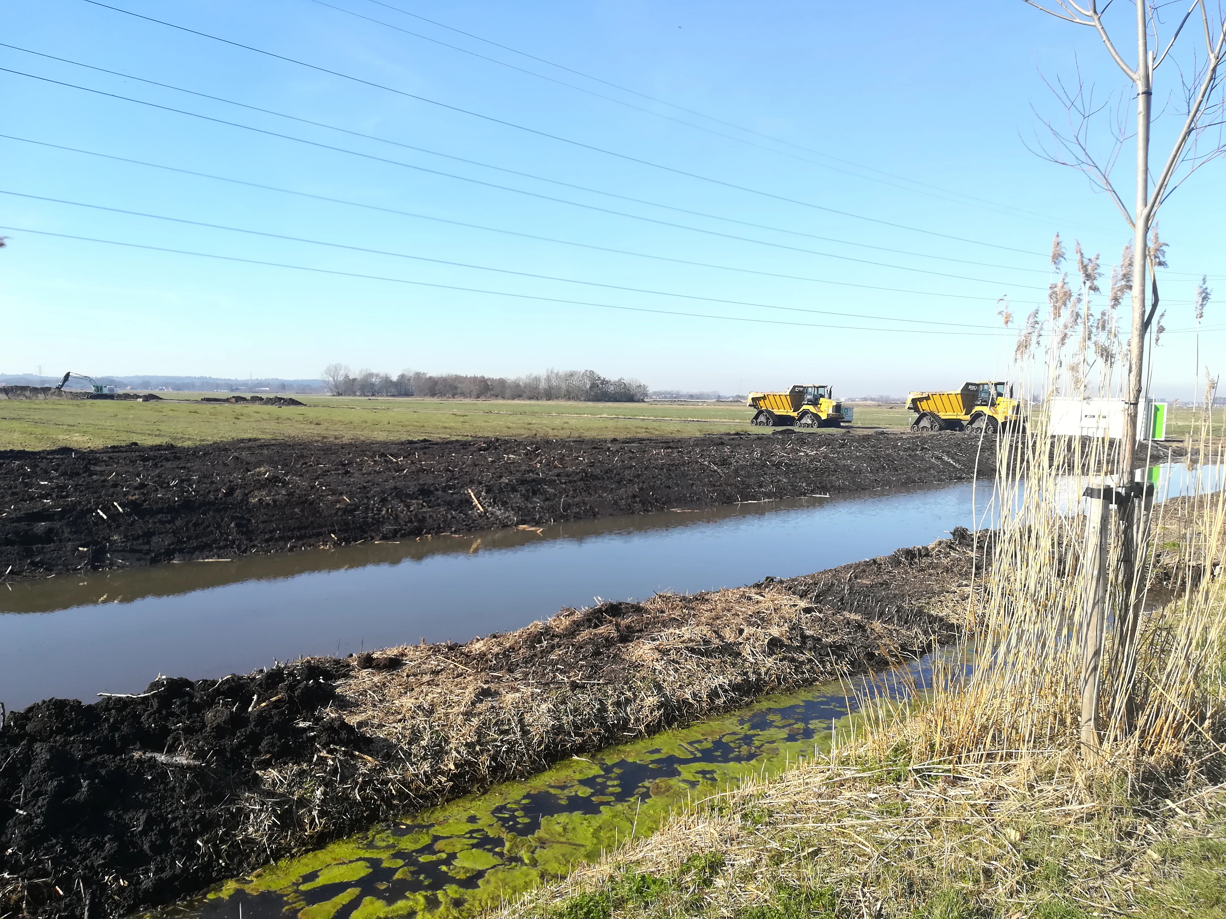
A wide view of a Dutch wetland landscape with a narrow canal in the foreground, excavated soil banks, and yellow construction vehicles operating in the distance under a clear blue sky.
Landscape restoration and earthmoving activity in the Binnenveld nature reserve.

Binnenveld ecosystems, habitats, and plant life

The ecological identity of Binnenveld is built on the meeting of mineral-rich groundwater, traditional meadow management, and surviving traces of ancient peatland. Two habitat types in particular define the Natura 2000 site: blue grassland, an extremely rare Dutch habitat of low-productive, species-rich meadows sustained by base-rich seepage; and quaking bog, a fragile, floating peatland that forms in stream valleys where groundwater under pressure keeps the peat saturated and slightly buoyant.

Together, these habitats support a rich flora adapted to wet, calcareous conditions, including the kind of sedges, orchids, and mosses that have largely vanished from the wider Dutch agricultural landscape. Outside the strictly protected reserves, the restored hay meadows of the Binnenveldse Hooilanden and Achterbergse Hooilanden extend the same ecological logic over a much larger area, providing continuity for meadow birds, marsh plants, and insects that depend on a network of suitably managed wet grassland.

Binnenveld wildlife and species highlights

Binnenveld is above all a landscape for meadow birds and wetland species. The traditional hay meadows and damp grasslands around the Natura 2000 reserves form an important refuge for ground-nesting birds typical of the Dutch countryside, such as lapwings, redshanks, godwits, and various species of duck and snipe that depend on open, wet meadows for feeding and breeding.

The rare flora of the blue grasslands and quaking bogs also supports a distinctive invertebrate community, including dragonflies, damselflies, and specialized butterflies and moths that rely on the combination of calcareous seepage, low-intensity mowing, and late-season flooding. Mammals typical of the wider countryside, including fox, roe deer along the wooded edges, and small mammals along the field margins, are also part of everyday Binnenveld fauna, using the reserves and surrounding meadows as stepping stones between larger habitat complexes.

Binnenveld conservation status and protection priorities

Binnenveld has become a focal point of Dutch lowland wet-grassland conservation. The designation of approximately 111 hectares as a Natura 2000 site gives the area formal European protection, anchoring the survival of two habitats of national and international importance: the blue grasslands of the Bennekomse Meent, and the quaking bogs of the Hel and Blauwe Hel. Province of Gelderland has additionally designated the wider Binnenveld as a meadow-bird area and a quiet zone, restricting housing, road, and industrial development and giving the broader cultural landscape a layer of planning protection.

Beyond these designations, the area is being physically reshaped for conservation. Former landfill sites near the Veensteeg and the Grift have been cleaned up, and about 70 hectares of former farmland were excavated in 2022 under Staatsbosbeheer to create new wet nature, forming the Achterbergse Hooilanden in Utrecht and connecting to the Binnenveldse Hooilanden in Gelderland. These restoration efforts, integrated into Natuurnetwerk Nederland, are intended to make the Natura 2000 site less isolated by surrounding it with ecologically compatible land.

Binnenveld cultural meaning and human context

Binnenveld is a cultural landscape as much as a natural one. Its long, straight roads, regular field patterns, and persistent use as meadowland all testify to the medieval origins of the Gelderse Vallei as a reclaimed and reorganized farming region. The very name Veenendaal, the town that grew within the western part of the Binnenveld, records the historical peat-cutting economy that once shaped this corner of the valley.

The area also has a strong contemporary identity as a contested rural landscape, in which local communities actively engage with questions of conservation, planning, and infrastructure. Plans to extend the A30 motorway through the Binnenveld, for example, have become a sensitive local issue, reflecting the broader Dutch debate over how to balance rural development with the protection of open countryside and Natura 2000 values. Community initiatives such as the Mooi Binnenveld residents' platform reflect this ongoing cultural engagement with the future of the area.

Top sights and standout views in Binnenveld

Binnenveld's strongest single feature is the Bennekomse Meent, one of the largest contiguous blue-grassland reserves in the Netherlands, complemented by the nearby Hel and Blauwe Hel, where calcareous seepage sustains an exceptionally rare stream-valley quaking bog. Beyond these two reserves, the wider Binnenveld combines traditional meadowland, restored hay-meadow nature areas, and protected quiet-zone status, making it a compact but unusually rich example of how a Dutch polder landscape can simultaneously support farming, meadow birds, and habitats of European importance.

Best time to visit Binnenveld

Late spring and early summer are typically the most rewarding seasons to experience Binnenveld, when the meadows are at their greenest and meadow-bird activity, from displaying lapwings to nesting redshanks, reaches its peak. Summer visits, especially early mornings, offer the best chance to see marsh flora in the blue grasslands and quaking bogs and to hear the characteristic sounds of insects and wetland birds. Winter brings a quieter, more austere beauty, with frost or light snow highlighting the contrast between the flat valley floor and the forested ridge of the Grebbeberg.

Monthly climate preview

Long-term representative measurements detailing monthly temperature ranges and precipitation patterns

Binnenveld Climate Normals, Annual Temperature and Precipitation Rhythm

Binnenveld displays a measured annual rhythm of monthly average temperatures and precipitation rates based on historical data. Examining the complete twelve-month profile provides deeper insight into long-term climate normals across the representative coordinate.
Annual mean10 °C
2 °C18 °C
Jan
Feb
Mar
Apr
May13°
Jun16°
Jul18°
Aug18°
Sep15°
Oct10°
Nov
Dec
Warmest month
July

18.1 °C

Coolest month
January

2.1 °C

Wettest month
December

2.6 mm/day

Driest month
April

1.4 mm/day

Park location guide

Geography guide, regional context, and park location map for Binnenveld

Binnenveld park geography, regions, and map view in Netherlands

Understand where Binnenveld sits in Netherlands through a broader geographic reading of the surrounding landscape, nearby location context, and its mapped position within the national park landscape.

How Binnenveld fits into Netherlands

The Netherlands is a low-lying coastal country in Northwestern Europe, famous for its extensive dike and canal systems that reclaim land from the sea. It consists of twelve provinces and is known for tulips, windmills, and cycling culture. The country is a founding member of the European Union with Amsterdam as its capital and The Hague as the seat of government.

Wider geography shaping Binnenveld in Netherlands

The Netherlands is located in Northwestern Europe along the North Sea coastline to the north and west. It borders Germany to the east and Belgium to the south. The country is notably flat, with a significant portion of its territory lying below sea level, protected by dikes and dune systems. It consists of twelve provinces and also includes overseas municipalities in the Caribbean.

Map view of Binnenveld

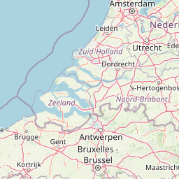
Use this park location map to pinpoint Binnenveld in Netherlands, understand its exact geographic position, and read its mapped placement within the surrounding landscape more clearly.

Pigeon | © OpenStreetMap contributors

Location context for Binnenveld

Gelderland

Explore high-resolution views of blue grassland, quaking bogs, and polder habitats.

Binnenveld Landscape Photos and Scenery: Visualizing Dutch Wetland Reserves

Visual documentation captures the unique wetland terrain, restored hay meadows, and low-lying polder environment characteristic of Binnenveld. Examining these protected habitats provides clear visual context for understanding rare plant communities and valley drainage patterns across the region.

A wide, flat field covered in frost with a large, frosted tree on the left and a flock of white birds resting in the snow in the distance.

A canal with calm water and reeds lining the banks, with open fields and a line of trees in the background under a cloudy sky.

A wide view of a Dutch wetland landscape with a narrow canal in the foreground, excavated soil banks, and yellow construction vehicles operating in the distance under a clear blue sky.

Park atlas

Compare adjacent wetland reserves and connected regional valley habitats

Explore Other Parks Near Binnenveld and Surrounding Protected Landscapes

Browse protected areas and natural reserves located near Binnenveld to examine regional wetland networks and valley ecosystems. Continuing the geographic comparison reveals how lowland polder habitats connect with wider conservation landscapes across the central Netherlands.
Protected areaNetherlands
About 6.6 km away#1 closest

Northeast

Veluwe: A Comprehensive Geographic Atlas of the Central Netherlands Protected Area

Glacial moraines, heathlands, and inland sand systems

Investigate the Veluwe, a premier protected area in the Gelderland province characterized by its historic push moraines and extensive ecological zones. The region encompasses significant sand drift complexes, dense woodlands, and vital spring-fed streams, offering a clear view of the diverse natural terrain found throughout the central Netherlands.

Area
1,000 km²
Relief
Upland
Climate
Temperate
Access
Easy access
Watercolor landscape showing green hills, forests, and a small stream with grassy patches
National parkUtrecht Province
About 9.7 km away#2 closest

West

Utrechtse Heuvelrug National Park: Mapped Protected Landscape and Geographic Atlas

Discover Utrecht Province's glacial ridge and diverse natural terrain.

Utrechtse Heuvelrug National Park is a significant protected natural area located in Utrecht Province, renowned for its unique glacial ridge topography. This entry provides detailed information about its mapped boundaries, diverse landscapes including heathlands and forests, and its importance as an ecological corridor within the Netherlands. Explore the park's distinct geography and its role in regional conservation through our structured atlas view.

Area
100 km²
Established
2003
IUCN
II
Visitors
1M annual
Watercolor painting of a lush, green landscape with ferns and grasses in the foreground and a soft, hazy forest line in the background.
Protected areaNetherlands
About 14 km away#3 closest

West

Kolland en Overlangbroek: Mapping the Rare Ash Floodplain Forest of the Netherlands

Historic estate landscape and protected woodland habitat.

Located between Wijk bij Duurstede and the Utrechtse Heuvelrug, Kolland en Overlangbroek preserves a vital fragment of alluvial ash forest. This protected area offers deep insight into Dutch floodplain geography, featuring a distinct mosaic of sandy ridges, silty backswamps, and centuries-old woodland managed for its unique bryophyte flora and groundwater-fed ecosystem.

Area
1.1 km²
Relief
Lowland
Climate
Temperate
Scope
Terrestrial
Watercolor painting of rolling hills, green trees, and a winding path
National parkGelderland
About 16 km away#4 closest

Northeast

De Hoge Veluwe National Park: Mapped Protected Landscape & Geographic Atlas Context

Explore Gelderland's unique heathland, sand dune, and woodland terrain.

De Hoge Veluwe National Park represents a distinctive protected area within the Gelderland region of the Netherlands. Its landscape is characterized by a unique mosaic of heathlands, sand dunes, and woodlands, shaped by ice age processes and historical land use. This page offers an atlas-focused exploration of its geographic setting, mapped boundaries, and the specific terrain that defines this significant natural and cultural heritage site.

Area
55 km²
Established
1935
IUCN
II
Visitors
629.4K annual
Watercolor illustration of a park landscape with a winding stream, grassy fields, and distant hills
National parkGelderland
About 25 km away#5 closest

East

Veluwezoom National Park: Protected Landscape Atlas and Gelderland Geography

Explore oldest Dutch national park, heathlands, and glacial terrain.

Veluwezoom National Park is the Netherlands' inaugural national park, located in Gelderland. This page provides an atlas-driven exploration of its protected landscape, characterized by rolling heathlands, ancient forests, and dramatic glacial push moraines. Users can discover the park's geographical features, mapped boundaries, and its significance as a conserved natural area within the Veluwe region.

Area
50 km²
Established
1930
IUCN
II
Relief
Upland
Nature reserveNetherlands
About 26 km away#6 closest

North

Arkemheen Nature Reserve: Geography and Protected Landscape Context in the Netherlands

Mapping medieval polder patterns and wetland bird habitats.

Arkemheen is a significant nature reserve in the Netherlands characterized by a flat, open polder landscape and historic fourteenth-century agricultural patterns. The area offers a distinct ecological profile, integrating freshwater border lakes with saline-influenced grasslands that support an internationally recognized population of meadow and wetland birds.

Area
14.3 km²
Established
1356
Relief
Lowland
Climate
Temperate
Nature reserveNorth Rhine-Westphalia
About 33 km away#7 closest

Southeast

Unterer Niederrhein Nature Reserve: Geographic Atlas and Floodplain Landscape Mapping

Riverine wetland ecosystems in North Rhine-Westphalia

Uncover the protected landscape of Unterer Niederrhein, an expansive bird protection area along the German Lower Rhine. The region features a mosaic of sand banks, oxbow lakes, and seasonally flooded grasslands, creating a highly interconnected riverine ecosystem that spans across the districts of Kleve and Wesel.

Area
258.094 km²
Established
1983
Relief
Lowland
Climate
Temperate
Nature reserveFlevoland
About 36 km away#8 closest

Northwest

Eemmeer & Gooimeer Zuidoever: Mapped Geography and Protected Lake-Fringe Landscape

A Natura 2000 wetland reserve within the Flevoland region

The Eemmeer & Gooimeer Zuidoever nature reserve consists of two distinct yet interconnected lake basins that represent the evolving landscape of the central Netherlands. The area is defined by its shallow water fringes and marshy shorelines, which provide essential sanctuary for waterbirds. By tracing the boundary between engineered polders and older mainland provinces, this reserve provides a unique look at the ecological significance of the former Zuiderzee remnants.

Area
15.84 km²
Established
2009
Relief
Lowland
Climate
Temperate

Common questions about visiting, size, designation, and location context for Binnenveld

Binnenveld FAQs for park facts, access, geography, and protected area context

Find quick answers about Binnenveld, including protected-area facts, park geography, trail and visitor context, and how the park fits into its surrounding country and regional landscape.
MoriAtlas Explorer

Continue Your Protected Areas Search Across the Global Atlas

Deepen your exploration by continuing the structured search for national parks and protected areas worldwide. Utilize the comprehensive filtering capabilities to compare different conservation landscapes and refine your understanding of global park geography. Discover more about the distribution and characteristics of protected natural areas.

Global natural geography