

Mori Atlas logo
National parkBirougou National Park

Discover the geographic context and protected area boundaries of this key national park.

Birougou National Park: Gabon's Protected Landscape Atlas and Mapped Geography

Birougou National Park stands as a significant protected natural area within Gabon, offering rich opportunities for geographic exploration and atlas-based discovery. Situated in Central Africa, this national park contributes to the country's mosaic of protected lands. Understanding its location and mapped boundaries is crucial for appreciating its role in the regional geography and the broader context of conservation landscapes in Gabon. Explore the mapped terrain and understand the park's unique geographic identity.

RainforestMountain ParksEndemic SpeciesRamsar SitesOld-Growth ForestPrimate Habitats

Birougou National Park

National park

Park overview

Structured park overview, official facts, and landscape profile for Birougou National Park

Birougou National Park park facts, protected area profile, and essential visitor context
Review the core facts for Birougou National Park, including designation, size, terrain, visitor scale, habitats, and operating context in one park-focused overview.

About Birougou National Park

Birougou National Park occupies a distinctive position in Gabon's protected area network as one of the most biologically significant old-growth rainforest reserves in central Africa. The park is located in the Chaillu Mountains, a range that forms one of the most elevated and rugged landscapes in Gabon, with Mount Birougou rising prominently as one of the country's highest peaks at 975 meters above sea level. This combination of significant elevation change and relatively isolated location has allowed the forest to develop exceptional ecological integrity, with some of the densest rainforest vegetation found anywhere in the region. The park's wetlands, known as the Marais des monts Birougou or Monts Birougou Wetlands, represent an important ecological component that contributes to the park's designation as a Ramsar site, recognizing its international importance as a wetland ecosystem. The protection of this landscape reflects Gabon's broader commitment to preserving its extraordinary forest biodiversity, and Birougou represents a flagship site within the national parks system.

Quick facts and research context for Birougou National Park

Birougou National Park is located in central Gabon within the Chaillu Mountains, one of the country's highest and most rugged mountain ranges. The park covers roughly 690 square kilometers of predominantly old-growth rainforest and was formally established in 2002 under Gabon's national parks system. It is governed by the National Agency for National Parks and received Ramsar Wetland designation in February 2007, recognizing its significant wetland and forest habitats. The park is named for Mount Birougou, a prominent 975-meter peak that anchors the protected area and offers sweeping views across the surrounding forest canopy.

Park context

Deeper park guide and search-rich context for Birougou National Park

Birougou National Park history, landscape, wildlife, and travel context
Explore Birougou National Park through its history, landscape character, ecosystems, wildlife, conservation priorities, cultural context, and seasonal travel timing in a structured park guide built for atlas discovery and search intent.

Why Birougou National Park stands out

Birougou National Park is best known as a critical refuge for the sun-tailed guenon, a primate species first described to science in 1988 and found in only two protected areas in Gabon. This endemic monkey represents one of the park's most distinctive biological treasures, though the entire ecosystem supports exceptional biodiversity within its dense rainforest environment. The park also contains the Monts Birougou Wetlands, a Ramsar-designated marsh system that adds ecological diversity to the mountainous terrain.

Birougou National Park history and protected-area timeline

Birougou National Park was officially established in 2002 as part of Gabon's expansion of its national parks network during the early 2000s. The creation of the park reflected growing recognition of the Chaillu Mountains' exceptional biodiversity value and the urgent need to protect the remaining old-growth forest in this region. In 2005, the park was nominated for inclusion on UNESCO's World Heritage List, with the submission emphasizing its universal cultural and natural significance. The following year, in February 2007, portions of the park were formally designated as a Ramsar Wetland site under the Ramsar Convention, recognizing the importance of the Monts Birougou Wetlands as a significant wetland ecosystem. This combination of national park status and international Ramsar designation has helped ensure ongoing conservation attention and resources for the area.

Birougou National Park landscape and geographic character

The landscape of Birougou National Park is defined by the Chaillu Mountains, a prominent mountain range in central Gabon that rises dramatically from the surrounding lowland terrain. The park's terrain is characterized by steep ridges, narrow valleys, and the prominent bulk of Mount Birougou, which at 975 meters represents one of the highest points in Gabon. The vegetation is predominantly dense tropical rainforest, with the forest canopy reaching impressive heights in this old-growth environment. The Monts Birougou Wetlands occupy lower-lying areas within the park, creating a mosaic of forest and wetland habitats that adds ecological diversity to the mountainous landscape. This combination of elevated terrain, dense forest cover, and wetland areas creates a visually striking and ecologically varied landscape.

Birougou National Park ecosystems, habitats, and plant life

The nature of Birougou National Park centers on its exceptionally well-preserved tropical rainforest ecosystem within the Chaillu Mountains. The old-growth forest here represents some of the most intact rainforest in central Gabon, with high canopy trees, complex vertical structure, and minimal human disturbance. The wetland component, known as the Monts Birougou Wetlands, adds important ecological diversity to the park, providing habitat for species adapted to wetland conditions while also supporting forest species in the surrounding areas. The combination of elevation change, from valley floors to mountain peaks, and the presence of both forest and wetland habitats creates a mosaic of ecological conditions that supports remarkable biodiversity. This ecological richness was a primary factor in the park's inclusion on UNESCO's World Heritage Tentative List.

Birougou National Park wildlife and species highlights

The wildlife of Birougou National Park is distinguished above all by the presence of the sun-tailed guenon, a primate species that was only first described to science in 1988 and remains endemic to Gabon, found in only two protected areas including Birougou. This relatively recent scientific discovery underscores how much remains to be learned about the park's biodiversity. The dense rainforest environment supports a diversity of forest-dwelling species, with the old-growth canopy providing habitat for numerous bird species, mammals, and invertebrates. The wetland areas within the park provide additional habitat for species adapted to more aquatic conditions, creating ecological variety that enhances the overall biodiversity value of the protected area.

Birougou National Park conservation status and protection priorities

Birougou National Park represents a significant conservation priority within Gabon and internationally. The park's dual designations as a national park under Gabon's protected area system and as a Ramsar Wetland site since 2007 reflect its recognized importance for both forest and wetland conservation. Its inclusion on UNESCO's World Heritage Tentative List since 2005 further signals its potential global significance as an outstanding natural area. The protection of the sun-tailed guenon represents a particular conservation priority, as this species is endemic to Gabon and found in very limited locations. The park's role in preserving old-growth forest in the Chaillu Mountains contributes to broader conservation goals for Gabon's forest estate, which covers a substantial portion of the country and represents one of the most important tropical forest regions in Africa.

Birougou National Park cultural meaning and human context

The cultural context for Birougou National Park is rooted in the broader relationship between Gabon's forest communities and the natural landscape. The park is situated in a region where local communities have maintained connections to the forest environment for generations, though detailed information about specific cultural heritage sites within the park is limited in available sources. The park's name derives from Mount Birougou, reflecting the significance of this prominent landscape feature in regional identity. The French name Marais des monts Birougou indicates the historical use of the local French language in describing the area.

Top sights and standout views in Birougou National Park

Birougou National Park offers exceptional opportunities to experience pristine old-growth rainforest in the Chaillu Mountains, one of Gabon's most elevated and rugged landscapes. The chance to observe the endemic sun-tailed guenon, a recently described primate found in only two parks in Gabon, represents a unique wildlife viewing opportunity. The Monts Birougou Wetlands add ecological variety and the Ramsar designation underscores the international importance of this wetland-forest mosaic. The park's position as a World Heritage Tentative List site signals its outstanding universal value as a conservation area.

Best time to visit Birougou National Park

The optimal time to visit Birougou National Park typically corresponds to Gabon's dry season, which generally runs from approximately June through September. During this period, reduced rainfall facilitates access to park areas and wildlife viewing opportunities tend to improve as animals concentrate around remaining water sources. The wet season, from October through May, brings heavier precipitation that can limit accessibility and make some trail conditions more challenging. Visitors planning trips to the park should consult current conditions and work with local operators familiar with seasonal access patterns.
Park location guide

Geography guide, regional context, and park location map for Birougou National Park

Birougou National Park park geography, regions, and map view in Gabon
Understand where Birougou National Park sits in Gabon through a broader geographic reading of the surrounding landscape, nearby location context, and its mapped position within the national park landscape.

How Birougou National Park fits into Gabon

Gabon is a Central African country on the Atlantic coast, positioned on the equator. It gained independence from France in 1960 and is governed as a unitary presidential republic. The country has significant oil wealth and one of the highest Human Development Index rankings in Africa, though wealth distribution remains uneven.

Wider geography shaping Birougou National Park in Gabon

Gabon is situated on the Atlantic coast of Central Africa, positioned along the equator. It borders Equatorial Guinea to the northwest, Cameroon to the north, and the Republic of the Congo to the east and south. The terrain includes coastal plains along the Atlantic, mountain ranges in the center (the Cristal Mountains and Chaillu Massif), and savanna zones in the east.

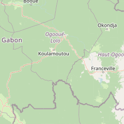
Map view of Birougou National Park

Use this park location map to pinpoint Birougou National Park in Gabon, understand its exact geographic position, and read its mapped placement within the surrounding landscape more clearly.

Pigeon | © OpenStreetMap contributors
Park atlas

Explore Regional Protected Landscapes and Mountain Rainforests Across Central Africa's Atlas Geography

Discover Other National Parks and Protected Areas Near Birougou National Park in Gabon
Browse additional national parks and protected areas near Birougou National Park to continue exploring Gabon's diverse conservation landscapes, including rainforests and mountainous terrain. Compare the regional context of Central Africa's protected areas, tracing ecological connections and understanding the broader geographic spread of critical conservation zones.
National parkGabon

Waka National Park: A Mapped Protected Landscape in Gabon's Geography

Explore the natural terrain and park boundaries of this national park.

Waka National Park in Gabon represents a vital protected landscape for geographic exploration. This dedicated detail page offers insight into the park's specific mapped area and its place within the country's broader natural terrain. Understand its context as a national park, contributing to the atlas of protected areas in Central Africa. Discover the geographic identity of this significant natural reserve.

Area
1,060 km²
Established
2002
IUCN
II
Relief
Mountain
Watercolor painting of a landscape with grassy areas, a lake, and distant hills under a light sky
National parkGabon

Lopé National Park: Gabon's Protected Landscape and National Park Geography

Explore mapped boundaries and natural terrain in Central Africa.

Delve into Lopé National Park, a designated national park situated in Gabon. This protected area serves as a crucial point for understanding the nation's geography and the distribution of its conservation landscapes. As an entry in the MoriAtlas, it offers a detailed view of its mapped territory and its contribution to the broader regional context of Central Africa, emphasizing its role in protected area atlas exploration.

Area
4,910 km²
Established
2002
IUCN
II
Relief
Mixed relief
National parkHaut-Ogooué Province

Batéké Plateau National Park: Mapped Geography of a Central African Forest-Savanna Mosaic

Discover the terrain and protected landscape of Haut-Ogooué Province.

Batéké Plateau National Park is defined by its expansive forest-savanna mosaic, a rare ecological formation across Central Africa. Located within Haut-Ogooué Province, this national park showcases unique terrain characterized by savanna grasslands interspersed with woodlands and forested corridors. Understanding its geographic context and protected boundaries provides valuable insight into the region's natural heritage and conservation significance.

Area
2,034 km²
Established
2002
IUCN
II
Relief
Upland
National parkGabon

Ivindo National Park: A Protected Rainforest Landscape in Gabon

Explore its waterfalls, diverse ecosystems, and mapped geographic context.

Ivindo National Park represents a significant protected landscape within Gabon, spanning a vast area of intact tropical rainforest. Recognized as a UNESCO World Heritage Site, the park is defined by the Ivindo River and its dramatic waterfalls, including the famous Kongou and Mingouli Falls. Its geography includes mountainous terrain and vital riverine ecosystems, supporting critical populations of forest elephants and great apes. This page offers a gateway to understanding the park's protected status, its unique natural features, and its role in the broader geography of Central Africa.

Area
3,000 km²
Established
2002
IUCN
II
Relief
Mixed relief
National parkGabon

Moukalaba-Doudou National Park: Gabon's Forest-Savanna Mosaic Protected Landscape

Atlas exploration of unique habitats and geographic boundaries.

Moukalaba-Doudou National Park in Gabon offers a distinctive atlas exploration experience, characterized by its remarkable combination of humid tropical rainforest and savanna grasslands. Covering a vast area, this protected landscape provides critical habitat and showcases a rare ecological transition zone within Central Africa. Understanding its mapped geography and protected-area status is key to appreciating Gabon's conservation efforts and the diverse natural terrains it preserves.

Area
4,500 km²
IUCN
II
Scope
Terrestrial
Water
Minor water
Watercolor painting showing a river with green hills and pink flowers in the foreground
National parkKouilou Department

Conkouati-Douli National Park: Mapping Protected Landscape Boundaries and Regional Geography

Explore its national park status and geographic context.

Conkouati-Douli National Park is a protected area situated in the Kouilou Department, offering a focused point for geographic and landscape discovery. This detail provides an atlas-style perspective on its mapped boundaries and its contribution to the regional geography. Understand the park as a distinct natural landscape and a key component of conservation within its geographic setting.

Area
7,955 km²
Established
1999
IUCN
II
Relief
Lowland
National parkGabon

Mayumba National Park: Gabon's Equatorial Protected Area and Geographic Atlas

Explore mapped park boundaries and regional landscape context.

Delve into the geographic identity of Mayumba National Park, a significant protected area situated in Gabon. This detail page provides atlas-style insights into the park's mapped boundaries, its position within the equatorial geography of Central Africa, and its role as a national park. Understand the protected landscape's environmental context and its atlas significance.

Area
870 km²
Established
2002
IUCN
II
Relief
Lowland
National parkGabon

Loango National Park: Gabon's Coastal Wilderness and Unique Protected Landscape

Explore savanna, forest, beach, and lagoon ecosystems in this vital national park.

Loango National Park in Gabon is a significant protected area recognized for its remarkable geographic diversity. This national park encompasses over 100 kilometers of pristine, uninhabited Atlantic coastline, rare mangrove systems, and expansive savanna plains transitioning into dense tropical forests. Its unique landscape, particularly the Iguéla Lagoon, offers rich opportunities for atlas-style exploration of coastal ecosystems and protected areas. Understanding the park's mapped boundaries and regional setting is key to appreciating its ecological importance.

Area
1,550 km²
Established
2002
IUCN
II
Relief
Lowland

Common questions about visiting, size, designation, and location context for Birougou National Park

Birougou National Park FAQs for park facts, access, geography, and protected area context
Find quick answers about Birougou National Park, including protected-area facts, park geography, trail and visitor context, and how the park fits into its surrounding country and regional landscape.
MoriAtlas Explorer

Continue Your Protected Areas Search Across the Global Atlas

Deepen your exploration by continuing the structured search for national parks and protected areas worldwide. Utilize the comprehensive filtering capabilities to compare different conservation landscapes and refine your understanding of global park geography. Discover more about the distribution and characteristics of protected natural areas.

Global natural geography