Mori Atlas logo
National parkBù Gia Mập National Park

Explore the mapped boundaries and natural terrain of this national park in Southeast Vietnam.

Bù Gia Mập National Park: Discover Vietnam's Protected Landscape in Bình Phước Province

(Vườn quốc gia Bù Gia Mập)

Bù Gia Mập National Park represents a key protected landscape within the southeastern region of Vietnam, specifically situated in the former Bình Phước Province. This national park offers a focused entry point for understanding regional geography and conservation efforts through its mapped protected area. Discover the park's natural terrain and its significance as a distinct element within the broader Vietnamese atlas of protected lands.

national parkold-growth forestdipterocarp forestprimatesbiodiversity hotspotCentral Highlands

Bù Gia Mập National Park

National park

Park overview

Structured park overview, official facts, and landscape profile for Bù Gia Mập National Park

Bù Gia Mập National Park park facts, protected area profile, and essential visitor context
Review the core facts for Bù Gia Mập National Park, including designation, size, terrain, visitor scale, habitats, and operating context in one park-focused overview.

About Bù Gia Mập National Park

Bù Gia Mập National Park represents a significant protected area in Vietnam's southern frontier, occupying a strategic position in the Đông Nam Bộ region near the border with Cambodia. The park's establishment in 2002 marked its formal recognition as a national park after prior status as a conservation area, reflecting Vietnam's commitment to preserving its remaining old-growth forest ecosystems. The terrain consists of low mountains and rolling hills that form part of the larger Central Highlands mountain system, with the highest peaks reaching approximately 700 meters. Multiple river systems traverse the park, including the Dak Huyet and Dak Sam, which contribute to the headwaters supporting hydroelectric generation at the Thác Mơ and Cần Đơn facilities. The park's management falls under the Bình Phước provincial government, with a substantial buffer zone extending into neighboring provinces. Beyond its ecological function as a biodiversity preserve, the park serves as a watershed protection area, scientific research site, environmental education center, and emerging ecotourism destination. The combination of its forest coverage, species diversity, and watershed value positions it as an important conservation asset within Vietnam's protected area network.

Quick facts and research context for Bù Gia Mập National Park

Bù Gia Mập National Park covers 260.32 square kilometers in the Đông Nam Bộ region of southern Vietnam, approximately 25 kilometers from Đồng Xoài city. The park was officially designated on November 27, 2002, under IUCN Category II protection. It features a 15,200-hectare buffer zone spanning parts of Đồng Nai and Lâm Đồng provinces. The area contains the headwaters for the Thác Mơ and Cần Đơn hydroelectric projects and is fed by river systems including the Dak Huyet and Dak Sam rivers. The park maintains extensive old-growth forest cover with notable populations of Dipterocarpaceae and Leguminosae tree species.

Park context

Deeper park guide and search-rich context for Bù Gia Mập National Park

Bù Gia Mập National Park history, landscape, wildlife, and travel context
Explore Bù Gia Mập National Park through its history, landscape character, ecosystems, wildlife, conservation priorities, cultural context, and seasonal travel timing in a structured park guide built for atlas discovery and search intent.

Why Bù Gia Mập National Park stands out

Bù Gia Mập National Park is best known for its extensive old-growth dipterocarp forests and its role as a refuge for Southeast Asian biodiversity. The park supports significant populations of endangered primates including the black-shanked douc and yellow-cheeked gibbon, along with large mammals such as gaur and Asian elephants. The Germain's peacock pheasant, a distinctive ground-dwelling bird, has been confirmed within the park, which also provides habitat for the orange-necked partridge. The combination of evergreen and semi-deciduous tropical forest types, coupled with its position in the Central Highlands, makes it one of Vietnam's more ecologically significant protected areas.

Bù Gia Mập National Park history and protected-area timeline

Bù Gia Mập National Park traces its formal protection history to its designation as a conservation area prior to 2002. On November 27, 2002, Vietnam's Prime Minister issued Decision No. 170/2002/QĐ-TTG, officially reclassifying the area as a national park and elevating its protection status. This transformation reflected growing recognition of the site's ecological significance and the need for more robust conservation measures to safeguard its biodiversity and watershed functions. Prior to formal protection, the area had long been recognized for its forest resources and ecological value, though comprehensive scientific surveys were conducted primarily in the late 1990s and early 2000s. The park's establishment also aligned with Vietnam's broader strategy of expanding its national park network during this period. Management responsibility was assigned to the provincial government of Bình Phước, with coordination across the buffer zone areas extending into Đồng Nai and Lâm Đồng provinces. Wildlife surveys conducted in collaboration with international organizations, particularly the Wildlife Conservation Society Cambodia Program, provided critical baseline data on species presence and conservation status in the years leading up to and following the park's designation.

Bù Gia Mập National Park landscape and geographic character

The landscape of Bù Gia Mập National Park consists of rolling hills and low mountain terrain forming part of the southern extent of Vietnam's Central Highlands. Elevations range from lower valleys up to approximately 700 meters at the highest points, creating a varied topography of ridges, slopes, and stream corridors. The park is drained by several river systems, including the Dak Huyet and Dak Sam rivers, which flow through the area and contribute to downstream water resources. These watercourses originate within the park boundaries and serve as critical headwaters for hydroelectric installations, including the Thác Mơ and Cần Đơn hydropower projects. The terrain supports diverse forest types, with semi-deciduous seasonal forest dominated by dipterocarp species occurring alongside evergreen rainforest in wetter areas, and significant bamboo forest in certain zones. The park's position near the Cambodian border places it within a contiguous forest landscape that extends across international boundaries, creating a transnational ecological corridor of regional importance.

Bù Gia Mập National Park ecosystems, habitats, and plant life

The ecological character of Bù Gia Mập National Park is defined by its extensive old-growth forest cover and the diversity of habitats it contains. Plant surveys have documented approximately 724 plant species across 326 genera, 109 families, and 70 orders, representing significant botanical diversity. The forests retain substantial primeval characteristics, with dominant tree families including the Dipterocarpaceae and Leguminosae. Notable tree species present include valuable timber species such as rosewood, cam lai, gõ đỏ, mun, lát hoa, thạch tùng, giáng hương, and trắc. The park contains multiple forest types: semi-deciduous tropical forest (including dipterocarp deciduous forest known locally as rừng khộp) and evergreen tropical rainforest characterized by species such as lồ ô. Additionally, substantial bamboo forest areas occur within the park boundaries. The documented presence of 278 medicinal plant species underscores the ecological and practical value of the park's flora. These diverse forest habitats support the rich animal communities that give the park its conservation significance.

Bù Gia Mập National Park wildlife and species highlights

Bù Gia Mập National Park supports remarkable mammalian diversity, with surveys documenting 73 mammal species, of which 59 appear in the Vietnam Red Book indicating threatened status. The park provides habitat for several globally significant species including the black-shanked douc, yellow-cheeked crested gibbon, and gaur. Primate diversity is particularly notable, with the park supporting populations including northern pigtail macaque, red-faced macaque, golden monkey, five-colored gibbon, and gray gibbon. Large mammals present include Asian elephant, banteng, dhole, sun bear, clouded leopard, and horse bear. The avifauna includes 168 bird species with 10 threatened with extinction, including the Germain's peacock pheasant which has been confirmed present, the orange-necked partridge which finds ideal habitat here, silver pheasant, great hornbill, and several pheasant and partridge species. Reptile diversity encompasses 30 species with 12 listed in the Vietnam Red Book. Additionally, more than 200 animal species within the park have documented medicinal value, ranging from primates and snakes to pythons, geckos, honey bees, and various bird species.

Bù Gia Mập National Park conservation status and protection priorities

Bù Gia Mập National Park serves multiple conservation functions that extend beyond simple habitat protection. As a Category II protected area under IUCN classification, it is recognized as a national park with primary objectives of ecosystem conservation and environmental protection. The park functions as a critical watershed protection zone, maintaining the headwaters that supply the Thác Mơ and Cần Đơn hydroelectric facilities, linking biodiversity conservation with renewable energy infrastructure. Its extensive old-growth forests represent increasingly rare habitats within Vietnam, making preservation of these areas ecologically critical. The documented presence of numerous species listed in the Vietnam Red Book, including 59 mammal species and 10 bird species of conservation concern, indicates the park's significance for threatened wildlife. The park also protects 278 medicinal plant species and over 200 animal species with medicinal value, representing important genetic resources. The transboundary location near Cambodia places the park within a larger regional conservation context, serving as part of a transnational ecological corridor that facilitates wildlife movement across international boundaries.

Bù Gia Mập National Park cultural meaning and human context

Bù Gia Mập National Park occupies land within the traditional territory of indigenous communities in southern Vietnam's Central Highlands region. The park takes its name from Bù Gia Mập commune, which lies within its boundaries, reflecting the long-established human presence in this landscape. The area has historically been associated with various ethnic minority communities whose traditional land use practices and forest relationships shaped the ecological character of the region over generations. While the park's establishment formalized conservation boundaries, the surrounding buffer zone spans portions of Đồng Nai and Lâm Đồng provinces, indicating the continued presence of local communities in proximity to the protected area. The park's designation as both a biodiversity preserve and watershed protection area reflects an integrated approach that considers both ecological values and the human communities dependent on the landscape's resources.

Top sights and standout views in Bù Gia Mập National Park

The most distinctive highlights of Bù Gia Mập National Park include its extensive old-growth dipterocarp forests among the most intact in Vietnam, significant populations of endangered primates including black-shanked douc and yellow-cheeked gibbon, and confirmed presence of the Germain's peacock pheasant. The park's role as a critical watershed protecting headwaters for major hydroelectric facilities adds functional significance to its ecological value. The diversity of forest types, from semi-deciduous seasonal forest to evergreen rainforest and bamboo zones, creates varied landscapes within a single protected area. The park's position near the Cambodian border places it within a transnational conservation corridor, enhancing its regional ecological importance.

Best time to visit Bù Gia Mập National Park

The optimal visiting period for Bù Gia Mập National Park aligns with Vietnam's dry season, typically from November through April, when precipitation is reduced and trail conditions are more favorable for exploration. The wet season from May through October brings heavier rainfall that can affect accessibility and visibility within the forest. Temperature conditions remain warm year-round given the park's lowland to mid-elevation location in the tropical zone. Wildlife activity patterns may vary seasonally, with drier months often providing better opportunities for animal sighting as creatures concentrate around remaining water sources. Visitors interested in birdwatching should consider that different species may be more observable during particular seasons, though comprehensive survey data on seasonal patterns remains limited.
Park location guide

Geography guide, regional context, and park location map for Bù Gia Mập National Park

Bù Gia Mập National Park park geography, regions, and map view in Vietnam
Understand where Bù Gia Mập National Park sits in Vietnam through a broader geographic reading of the surrounding landscape, nearby location context, and its mapped position within the national park landscape.

How Bù Gia Mập National Park fits into Vietnam

Vietnam, officially the Socialist Republic of Viet Nam, is a unitary communist state in Southeast Asia. It occupies roughly 331,000 square kilometres along the eastern edge of Mainland Southeast Asia, with a population exceeding 102 million. The country is bordered by China to the north, Laos and Cambodia to the west, and has maritime boundaries in the Gulf of Thailand and South China Sea.

Wider geography shaping Bù Gia Mập National Park in Vietnam

Vietnam occupies the eastern edge of Mainland Southeast Asia, stretching along the Gulf of Thailand to the southwest and the South China Sea to the east. The country is bordered by China to the north, and Laos and Cambodia to the west. It has a diverse landscape ranging from the Red River Delta in the north to the Mekong Delta in the south.

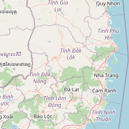
Map view of Bù Gia Mập National Park

Use this park location map to pinpoint Bù Gia Mập National Park in Vietnam, understand its exact geographic position, and read its mapped placement within the surrounding landscape more clearly.

Pigeon | © OpenStreetMap contributors

Location context for Bù Gia Mập National Park

Bình Phước Province
Park atlas

Explore the geographic spread of protected areas, comparing landscapes within Vietnam's Central Highlands and adjacent regions.

Discover Related National Parks and Protected Areas Near Bù Gia Mập National Park
After exploring Bù Gia Mập National Park, discover other national parks and protected areas situated across Vietnam's Central Highlands. This curated atlas view allows for geographic comparison, revealing regional conservation landscapes, diverse forest types, and shared ecological corridors for further exploration.
Watercolor illustration of a landscape with rolling hills, green vegetation, and a body of water
National parkVietnam

Cát Tiên National Park: Vietnam's Premier Protected Lowland Forest and Wetland Atlas

Explore the mapped boundaries and diverse ecosystems of this vital national park.

Cát Tiên National Park represents a significant ecological reserve in southern Vietnam, covering a vast expanse of lowland tropical forest and critical wetland habitats. The park's landscape is shaped by seasonal flooding from the Dong Nai River, creating unique ecosystems like the renowned Bàu Sấu (Crocodile Lake) and supporting diverse flora and fauna. Understanding Cát Tiên National Park's geography, its protected landscape character, and its position within Vietnam offers valuable insights for atlas-based exploration of Southeast Asia's natural heritage.

Area
720 km²
Established
1992
IUCN
II
Relief
Lowland
National parkĐắk Lắk Province

Yok Đôn National Park: Vietnam's Expansive Lowland Forest Protected Landscape and Regional Geography

Mapped boundaries within Đắk Lắk Province, part of a transboundary conservation area.

Yok Đôn National Park is Vietnam's largest lowland forest national park, covering approximately 1,155 square kilometers in Đắk Lắk Province. This protected area is characterized by its rare khộp forest ecosystem and serves as a crucial refuge for large mammals. Situated near the Cambodian border, it forms a key component of one of Southeast Asia's largest continuous protected area networks, offering significant insights into regional protected landscape geography and conservation connectivity.

Area
1,155.45 km²
Established
1986
IUCN
II
Relief
Lowland
National parkĐắk Nông Province

Tà Đùng National Park: Protected Landscape and Geographic Atlas Entry

Mapped Boundaries and Regional Terrain Context

Tà Đùng National Park represents a vital protected landscape within Vietnam's Đắk Nông Province, offering rich opportunities for geographic discovery. This entry details the park's identity as a national park, focusing on its mapped boundaries and its contribution to the regional atlas. Explore the fundamental geographic features and protected land context that define Tà Đùng National Park, facilitating a deeper understanding of its place within the broader natural landscape.

Area
209 km²
Established
2018
IUCN
II
Relief
Mountain
National parkRatanakiri province

O'Yadav National Park: Protected Forest Conservation in Ratanakiri Province

Explore mapped boundaries and regional landscape context.

O'Yadav National Park is a national park located in northeastern Cambodia's Ratanakiri province, designated to protect significant forest ecosystems and serve as a vital link in the nation's biodiversity corridor system. Spanning 105,019 hectares, the park encompasses forested terrain and includes the historically significant Yak Nang temple site. Its conservation efforts contribute to the ecological integrity of the broader Indochinese region, making it a key protected landscape for atlas-based geographic study.

Area
1,050.19 km²
Established
2016
IUCN
II
Scope
Terrestrial
National parkLâm Đồng Province

Bidoup Nui Ba National Park: Vietnam National Park Atlas and Protected Landscape

Explore mapped boundaries and regional geography of this protected area.

Bidoup Nui Ba National Park is a prominent national park located within the Lâm Đồng Province of Vietnam's Central Highlands. This park serves as a focal point for understanding the regional geography and the distribution of protected lands across Vietnam. Its mapped boundaries define a significant natural landscape, offering users detailed atlas-style context for geographic exploration and protected-area research.

Area
648 km²
Established
2004
IUCN
II
Relief
Mountain
National parkTây Ninh Province

Lò Gò, Xa Mát National Park: Exploring Protected Landscape Boundaries and Regional Geography

Vietnam National Park Mapped Terrain and Atlas Context

Discover Lò Gò, Xa Mát National Park, a vital protected area situated in Tây Ninh Province. This entry focuses on its role as a national park, providing key insights into its mapped boundaries and contribution to the regional geography. Understand its landscape context as part of a broader atlas of protected lands, offering a factual basis for geographic discovery and conservation area research.

Area
300.22 km²
Established
2002
IUCN
II
Relief
Lowland
Watercolor illustration of a river, trees, and hills in a natural landscape.
National parkĐắk Lắk Province

Chư Yang Sin National Park: Mapped Protected Landscape in Đắk Lắk Province

Explore its protected boundaries and regional geographic context.

Chư Yang Sin National Park stands as a key protected natural area within Vietnam's Central Highlands. This national park, located in the expansive Đắk Lắk Province, provides a rich subject for geographic discovery. Understanding its mapped boundaries and position within the regional landscape offers valuable context for atlas-based exploration of Vietnam's protected lands.

Area
589.47 km²
Established
2002
IUCN
II
Scope
Terrestrial
National parkNinh Thuận Province

Phước Bình National Park: Protected Area Identity and Geographic Setting in Ninh Thuận

Explore Vietnam's Phước Bình National Park and its mapped terrain.

Phước Bình National Park represents a distinct national park entity situated within Ninh Thuận Province, Vietnam. This destination facilitates an atlas-driven understanding of its protected landscape, emphasizing its geographical placement and mapped boundaries. Explore the core identity of this park as a component of Vietnam's protected areas network and its specific regional landscape context.

Area
198.14 km²
Established
2006
IUCN
II
Relief
Mountain

Common questions about visiting, size, designation, and location context for Bù Gia Mập National Park

Bù Gia Mập National Park FAQs for park facts, access, geography, and protected area context
Find quick answers about Bù Gia Mập National Park, including protected-area facts, park geography, trail and visitor context, and how the park fits into its surrounding country and regional landscape.
MoriAtlas Explorer

Continue Your Protected Areas Search Across the Global Atlas

Deepen your exploration by continuing the structured search for national parks and protected areas worldwide. Utilize the comprehensive filtering capabilities to compare different conservation landscapes and refine your understanding of global park geography. Discover more about the distribution and characteristics of protected natural areas.

Global natural geography