
Viewpoints
Park geography
Technical overview of regional land classification, terrain relief, and environmental landscape composition.
Chobe National Park: Comprehensive Geographic Profile, Mapped Boundaries, and Natural Features
This geographic dataset details the spatial scope of Chobe National Park across 11700 square kilometers in Botswana. The profile captures essential terrain data including mixed relief and diverse environmental features like wetlands, riverine systems, tropical forests, and savanna grasslands.
Related tags
Elephant ConservationBig Five HabitatRiverine EcosystemsSavanna WetlandsPredator Populations
Botswana's most biologically diverse wilderness home to the world's largest elephant population
Chobe National Park
Chobe National Park is Botswana's first national park and the most biologically diverse protected area in the country. Located in the northern region of Botswana, this vast wilderness spans approximately 11,700 square kilometers and encompasses an extraordinary variety of ecosystems, from lush riverfront floodplains to expansive savanna marshes. The park is internationally renowned for its extraordinary elephant populations, with an estimated 50,000 Kalahari elephants roaming its landscapes. What makes Chobe particularly special is the remarkable diversity of habitats within a single protected area: the crocodile-and-hippopotamus-rich waters of the Chobe River, the periodically flooded Savuti Marsh with its iconic dead tree-lined channel, the remote Linyanti Marshes teeming with predators, and the dry hinterland woodlands of Nogatsaa. The park's ecological significance is amplified by its position near the Zambezi region, making it accessible from the tourism hub of Kasane and serving as a gateway for visitors heading to Victoria Falls.
- Location
- Botswana
- Park type
- National park
- Established
- 1967
- Area
- 11,700 km²
Location overview
National jurisdiction and administrative positioning inside Botswana
Chobe National Park: Geographic Location and National Setting in Botswana
Chobe National Park is situated within the national borders of Botswana as a major protected territory. National records define the administrative positioning and sovereign alignment of the mapped landscape.
- Countries
- Botswana
- Primary location
- Botswana
Boundary and coordinates
Geographic dimensions and footprint spanning 11,700 square kilometers
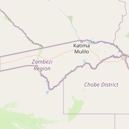
Chobe National Park Geographic Boundary Map and Spatial Extent
Interactive geographic mapping outlines the spatial footprint of Chobe National Park within the regional landscape. Accompanying spatial facts detail the approximate land area, coordinate limits, and central coordinates.
- Boundary area
- 10,511 km²
- Boundary perimeter
- 658 km
- Northernmost point
- 17.7878° S
- Southernmost point
- 19.3338° S
- Easternmost point
- 25.1847° E
- Westernmost point
- 23.8822° E
- Geographic centre
- 18.5493° S, 24.5067° E
- North–south span
- 171.1 km
- East–west span
- 137.5 km
Terrain and natural features
Explore mixed relief categories and linked geographical entities across the protected landscape
Chobe National Park Terrain Classifications and Recorded Natural Features
Stored terrain classifications and mixed relief categories define the mapped landscape alongside recorded named natural features. Linked feature cards provide names, types, measurements, and spatial relationships where documented.
Selected named natural features
Peaks
Kudu Hills
Lakes
Waterhole
Viewpoints
Nogatsaa Game Hide
Islands
Sedudu Island
Viewpoints
Kalwezi-ke-Nkanga
Environmental setting
Recorded tropical climate, seasonal water presence, and habitat types
Chobe National Park Environmental Classifications and Physical Setting
Recorded landscape features, habitat types, and climate classifications provide interpretive lenses for understanding physical settings. Connected atlas destinations link these categories to broader regional geography.
- Relief
- Mixed relief
- Climate
- Tropical
- Water
- Major water bodies
- Forest cover
- Partial forest
- Seasonality
- Seasonal
Landscape features
Wetland · Forest · Woodland · Rivers · Grassland · Hills · Lakes · Valleys
Habitat types
Wetland · Riverine habitat · Tropical forest · Savanna · Grassland · Lacustrine habitat
Park atlas
Compare mapped protected landscapes and trace the regional spread of conservation areas surrounding Chobe National Park.
Explore Nearby National Parks and Protected Areas Beyond Chobe National Park
After exploring Chobe National Park's diverse ecosystems and renowned wildlife, browse a curated list of other national parks and protected areas in the surrounding region. Compare their unique riverine systems, savanna wetlands, and predator populations, offering deeper insights into Southern Africa's interconnected conservation landscapes.
National parkNamibia
About 25 km away#1 closest
West

Nkasa Rupara National Park: A Protected Landscape within Namibia's Geography
Explore the mapped protected area and its regional landscape context.
Nkasa Rupara National Park represents a distinct protected landscape within Namibia. This entry provides detailed geographic context, focusing on the park's mapped boundaries and its role as a national park. Understand how this protected area contributes to the broader regional geography, offering a focal point for atlas-based exploration of Namibia's natural lands.
- Area
- 320 km²
- Established
- 1990
- IUCN
- II
- Relief
- Lowland
National parkCaprivi Region
About 35 km away#2 closest
Northwest
Mudumu National Park National Park: Discover its Protected Landscape and Geographic Boundaries
Mapping the protected area and regional landscape context in Caprivi Region.
Navigate the protected geography of Mudumu National Park, a designated national park situated within the Caprivi Region. This entry provides a structured atlas view of its mapped boundaries and landscape context. Gain a clear understanding of its protected status and its place within the regional geographic framework, offering essential detail for map-based exploration of natural areas in Namibia.
- Area
- 737 km²
- Established
- 1990
- Relief
- Lowland
- Climate
- Tropical
National parkHwange District
About 50 km away#3 closest
Northeast

Zambezi National Park: National Park within Hwange District's Geographic Landscape
Explore mapped boundaries and protected area context.
Delve into Zambezi National Park, a designated national park situated in Hwange District. This entry provides foundational geographic and landscape context, highlighting the park's protected status and its position within the regional terrain. Understand the atlas significance and mapped features of this conservation landscape for informed discovery.
- Area
- 560 km²
- Established
- 1979
- Relief
- Lowland
- Climate
- Subtropical
National parkZimbabwe
About 56 km away#4 closest
East
Kazuma Pan National Park: Zimbabwe National Park Atlas and Protected Landscape Exploration
Unique plains landscape with reliable dry-season wildlife viewing.
Kazuma Pan National Park offers a rare glimpse into Zimbabwe's expansive grassy plains and vital pans, creating a unique protected landscape. This national park is critical for understanding regional wildlife migrations and the geographic context of conservation areas in northwestern Zimbabwe, providing an essential entry point for atlas-based exploration of its terrain and ecological significance.
- Area
- 313 km²
- Established
- 1975
- IUCN
- II
- Relief
- Lowland
National parkBotswana
59 km away#5 closest
South

Nxai Pan National Park: Botswana's Iconic Baobab Forests and Salt Pan Landscape
Explore mapped boundaries and unique regional geography.
Nxai Pan National Park offers a compelling glimpse into Botswana's unique semi-arid ecosystems, characterized by the expansive, salt-crusted Nxai Pan itself and the iconic Baines Baobabs dotting its edges. As a protected national park, it represents a significant conservation landscape within the Kalahari Desert region. Understanding its geography involves appreciating the stark visual contrasts, seasonal wetland transformations, and the vast openness of the salt pan environment.
- Area
- 2,578 km²
- Established
- 1992
- IUCN
- Ib
- Relief
- Lowland
National parkMatabeleland North
64 km away#6 closest
East
Hwange National Park: Explore its Mapped Boundaries and Protected Landscape in Matabeleland North
National Park with distinct geographic and landscape context.
Gain a structured understanding of Hwange National Park, a designated national park within the Matabeleland North region of Zimbabwe. This detailed entry focuses on its precise mapped boundaries and its contribution to the regional geography. Ideal for atlas-based discovery, it highlights Hwange National Park as a key protected landscape for understanding conservation and natural terrain distribution.
- Area
- 14,651 km²
- Established
- 1961
- IUCN
- II
- Relief
- Lowland
National parkZambezi Region
69 km away#7 closest
West
Bwabwata National Park: National Park in the Zambezi Region, Namibia
Explore savanna ecosystem and riverine landscapes.
Bwabwata National Park represents a significant protected landscape in Namibia's Zambezi Region, notable for its integrated community conservation model and its function as a vital wildlife corridor. This national park spans the Caprivi Strip, featuring savanna woodlands and crucial riparian zones along the Okavango and Kwando rivers. As a key component of the Kavango-Zambezi Transfrontier Conservation Area, it facilitates significant elephant migrations, providing rich opportunities for atlas-based exploration of mapped protected areas and regional geography.
- Area
- 6,274 km²
- Established
- 2007
- IUCN
- II
- Relief
- Lowland
National parkZimbabwe
70 km away#8 closest
Northeast
Victoria Falls National Park: A Protected Landscape Within Zimbabwe's Geography
Atlas exploration of park boundaries and natural terrain.
Victoria Falls National Park is a key component of Zimbabwe's protected natural areas. This page provides structured information ideal for atlas-based exploration, detailing the park's geographic position and mapped landscape features. Understand its significance as a national park and its contribution to the region's conservation geography.
- Area
- 23.4 km²
- IUCN
- II
- Relief
- Mixed relief
- Climate
- Tropical
MoriAtlas Explorer
Continue Exploring Chobe National Park's Geographic Context and Protected Area Atlas
Delve deeper into the geographical intricacies and protected landscape identity of Chobe National Park. Understanding its position within Botswana's atlas, its diverse mapped terrains, and the surrounding regional context offers a richer appreciation of this significant protected area. Continue your discovery of Chobe National Park's unique natural features and ecological importance.
Browse next
Global natural geography
Explore related park routes
Explore MoriAtlas Global ParksBrowse All MoriAtlas ParksGlobal Park Map DiscoveryMoriAtlas: Browse All CountriesBrowse All MoriAtlas ContinentsNational Park Environment AtlasGrand Canyon National Park AtlasYellowstone National Park AtlasYosemite National Park Atlas and GeographySerengeti National Park AtlasGalápagos National Park Protected LandscapeBanff National Park Geography and AtlasKruger National Park Atlas EntryUluṟu-Kata Tjuṯa National Park AtlasExplore Uluru-Kata Tjuta National Park GeographyPlitvice Lakes National Park AtlasFiordland National Park Protected LandscapeGreat Smoky Mountains National Park AtlasAfghanistan National Parks and Protected AreasAlbania National Parks and Protected AreasAlgeria National Parks and Protected AreasAmerican Samoa National Parks and Protected AreasAndorra National Parks and Protected AreasAngola National Parks and Protected AreasAntarctica National Parks and Protected AreasAntigua and Barbuda Park List