Mori Atlas logo
Wildlife reserveCiénaga de Los Olivitos

A comprehensive atlas overview of the diverse tidal channels, mangrove systems, and saline lagoon habitats.

Ciénaga de Los Olivitos Wildlife Reserve: Mapping Coastal Wetland Landscapes in Estado Zulia, Venezuela

(Refugio de Fauna Silvestre Ciénaga de Los Olivitos)

Ciénaga de Los Olivitos represents a significant coastal wetland complex spanning approximately 26,000 hectares along the Caribbean shore of western Venezuela. This protected area within Estado Zulia features an interconnected mosaic of tidal mangrove channels, expansive salt marshes, and shallow saline lagoons that serve as a critical habitat for diverse waterbird populations and marine fauna. Its unique position within the Lake Maracaibo basin highlights the intersection of arid tropical terrain and productive marine-influenced ecosystems.

coastal wetlandmangroveRamsar siteflamingoswildlife refugeCaribbean coast

Ciénaga de Los Olivitos

Wildlife reserve

Park overview

Structured park overview, official facts, and landscape profile for Ciénaga de Los Olivitos

Ciénaga de Los Olivitos park facts, protected area profile, and essential visitor context

Review the core facts for Ciénaga de Los Olivitos, including designation, size, terrain, visitor scale, habitats, and operating context in one park-focused overview.

About Ciénaga de Los Olivitos

Ciénaga de Los Olivitos lies along the western Venezuelan Caribbean coast, in the state of Zulia, and forms part of the broader wetland system associated with the Lake Maracaibo basin. The protected area covers a large tract of coastal terrain in Miranda Municipality, encompassing tidal channels lined with mangrove, saline lagoons, broad salt marshes, and stretches of beach. The combination of these habitats within a continuous protected area is what gives Los Olivitos its wider ecological importance.

The wetland has been formally protected under multiple designations. It was declared a Ramsar Wetland of International Importance on 4 September 1996, recognizing its value for waterbirds and for the broader ecological function it performs along the southern Caribbean shore. In addition, the area is administered as a Wildlife Refuge (Refugio de Fauna Silvestre) and as a Fishing Reserve, creating a layered system of protection that addresses both biodiversity conservation and sustainable use of fisheries.

Ecologically, Los Olivitos represents one of the more characteristic mangrove-lagoon complexes of northwestern Venezuela. The tidal channels and lagoon margins support mangrove vegetation, while more open saline flats and shallow waters provide feeding grounds for wading birds and large waterbirds, including flamingos. The mosaic of habitats, ranging from fully marine-influenced channels to more enclosed brackish lagoons and adjacent beach environments, supports both resident wildlife and seasonal migrant species, giving the wetland year-round ecological significance.

The climate of the area is arid, with relatively low annual rainfall and consistently warm temperatures throughout the year. Because the wetland depends on tidal inflow and seasonal balance between saltwater intrusion and freshwater input rather than rainfall alone, its lagoons and marshes maintain their ecological character even under dry climatic conditions. This combination of a protected coastal wetland set within an arid coastal landscape distinguishes Los Olivitos from many other Venezuelan wetlands further east, where rainfall is considerably higher.

Quick facts and research context for Ciénaga de Los Olivitos

Ciénaga de Los Olivitos is a coastal wetland and wildlife refuge located in the state of Zulia, in western Venezuela, administered within Miranda Municipality. The area was formally recognized as a Ramsar Wetland of International Importance on 4 September 1996 and covers approximately 26,000 hectares (roughly 260 square kilometers) of tidal mangroves, coastal lagoons, salt marshes, and beach habitats. It also holds the additional designation of Fishing Reserve and Wildlife Refuge, reinforcing its role in safeguarding both aquatic habitats and fisheries resources along this stretch of the Venezuelan Caribbean coast.

Protection and recognition

Documented management scope and official establishment timeline

Ciénaga de Los Olivitos Protection Status and Designated History

Ciénaga de Los Olivitos maintains a recorded mixed protection status established in nineteen ninety-six. Official records provide foundational baseline details regarding administrative oversight and conservation designation history without external recognition sources.

Protection details

Protection scope
Mixed
Designated year
1996
Transboundary protection
No
Park context

Deeper park guide and search-rich context for Ciénaga de Los Olivitos

Ciénaga de Los Olivitos history, landscape, wildlife, and travel context

Explore Ciénaga de Los Olivitos through its history, landscape character, ecosystems, wildlife, conservation priorities, cultural context, and seasonal travel timing in a structured park guide built for atlas discovery and search intent.

Why Ciénaga de Los Olivitos stands out

Ciénaga de Los Olivitos is best known for being one of the most important coastal wetland complexes of the Lake Maracaibo basin, recognized internationally under the Ramsar Convention. The wetland's shallow saline lagoons and mangrove channels host one of the most characteristic sights of the Venezuelan coast: large gatherings of Caribbean flamingos feeding in the warm tidal waters at dawn and dusk. The site is also notable for its combination of mangrove, marsh, and lagoon habitats within a single protected area, supporting caimans and manatees alongside waterbirds. This layering of habitats, combined with the area's arid tropical climate, gives Los Olivitos a distinctive ecological profile among Venezuela's protected wetlands.
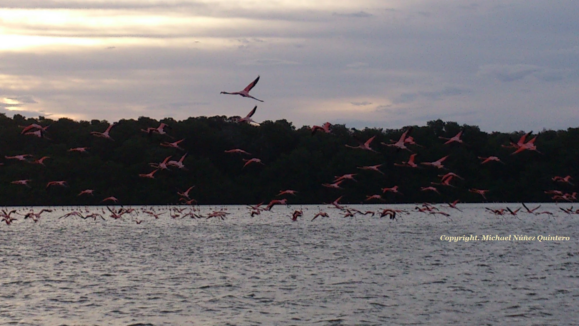
A large flock of pink flamingos flies low over a dark, rippling body of water, with a silhouette of a treeline in the background under a cloudy morning sky.
A large flock of Caribbean flamingos taking flight over the waters of Ciénaga de Los Olivitos at dawn.

Ciénaga de Los Olivitos history and protected-area timeline

The defining moment in the protection history of Ciénaga de Los Olivitos came on 4 September 1996, when the wetland was formally inscribed as a Ramsar site, recognizing its international importance under the Ramsar Convention on Wetlands. This designation established Los Olivitos as part of the global network of wetlands of significant ecological value and brought its mangrove, lagoon, and marsh habitats into an internationally coordinated conservation framework.

Alongside its Ramsar status, the wetland also operates as a Wildlife Refuge and a Fishing Reserve under Venezuelan national protection categories. These overlapping designations reflect an approach that combines biodiversity protection with regulated use of fisheries, given the importance of the lagoon and channel systems for local fishing communities. Together, the Ramsar listing and national refuge status form the principal institutional framework under which the area is currently conserved.

Ciénaga de Los Olivitos landscape and geographic character

The physical landscape of Los Olivitos is defined by the meeting of land and sea along the western Venezuelan coast. Tidal channels, lined with mangrove vegetation, thread through the wetland and connect the open marine influence of the Caribbean with a system of coastal lagoons and salt marshes. The result is a low-lying, flat coastal terrain where water, vegetation, and sediment form an interconnected mosaic.

Sandy beaches fringe parts of the protected area, while further inland the marsh and lagoon systems extend across broad saline flats. The terrain lacks significant elevation, and the visual character of the wetland comes from its expansive shallow waters, mirrored skies, and stands of mangrove. Because the local climate is arid, the surrounding landscape beyond the wetland is generally dry, which heightens the visual contrast of the water-rich wetland environment within its broader regional setting.

Ciénaga de Los Olivitos ecosystems, habitats, and plant life

Ecologically, Los Olivitos is shaped by the interplay between tidal influence, mangrove communities, and more open saline habitats. The mangrove systems stabilize tidal sediments and provide nursery habitat for marine and estuarine species, while the lagoons and salt marshes offer shallow, productive feeding grounds for a wide range of waterbirds.

This habitat layering makes the wetland productive across multiple ecological niches. The mangrove fringes support crustaceans, small fish, and the predators that depend on them. The open lagoon waters and salt pans are used by wading birds and flamingos, while the broader wetland mosaic supports reptiles and mammals adapted to brackish and saline conditions. The overall ecological character of Los Olivitos is therefore defined as much by the structure and connectivity of its habitats as by any single species group.

Ciénaga de Los Olivitos wildlife and species highlights

Los Olivitos is most recognized for its populations of Caribbean flamingos, which gather in the shallow saline waters of the lagoon system and are among the wetland's most visible and iconic species. The image of flamingos beginning their daily activity in the early morning is closely associated with the protected area's identity as a wildlife site.

Beyond flamingos, the wetland is also home to caimans of the coast (Caimán de la Costa), which inhabit the channels and lagoon margins, and to West Indian manatees, which use the more sheltered parts of the wetland system. The site as a whole supports a diverse fauna shaped by its coastal habitats. The combination of large, easily visible waterbirds with more cryptic reptiles and marine mammals gives Los Olivitos a varied wildlife profile that extends well beyond any single species.

Ciénaga de Los Olivitos conservation status and protection priorities

The principal conservation significance of Los Olivitos lies in its formal recognition as a Ramsar Wetland of International Importance, placing it within a global framework for the protection of wetlands and their dependent species. Its Ramsar inscription reflects the international value of its mangrove, lagoon, and marsh habitats for waterbird populations and for the broader ecological functioning of the Lake Maracaibo basin.

At the national level, the wetland is protected through its Wildlife Refuge and Fishing Reserve designations, which provide domestic legal mechanisms for managing habitat and resource use. The overlap of international recognition and national protection categories gives Los Olivitos a layered conservation framework, addressing both the safeguarding of habitat and the regulation of activities that depend on the wetland's productivity. Its arid-climate setting, combined with its position on a major Caribbean migratory route, makes it especially important as a refuge for waterbirds in a region where freshwater wetland alternatives are limited.

Ciénaga de Los Olivitos cultural meaning and human context

The wetland is associated with the fishing communities of Miranda Municipality in the state of Zulia, whose livelihoods have traditionally been tied to the productivity of the lagoons, channels, and coastal waters. The Fishing Reserve designation of Los Olivitos formally recognizes this relationship between the local human population and the wetland's natural resources, seeking to balance biodiversity protection with the continuation of regulated traditional use.

Top sights and standout views in Ciénaga de Los Olivitos

Los Olivitos stands out as one of Venezuela's most internationally recognized coastal wetlands, carrying both Ramsar and Wildlife Refuge status. Its combination of mangrove, lagoon, marsh, and beach habitats within a single protected area makes it a strong example of a layered coastal ecosystem, while its arid surrounding landscape gives it a distinctive regional setting.

Among its most distinctive highlights are the gatherings of Caribbean flamingos in the shallow saline waters, the presence of coastal caimans within the channel systems, and the occasional appearance of West Indian manatees in the more sheltered lagoon environments. Together these features give Los Olivitos a recognizable profile as a wetland refuge for both waterbirds and aquatic fauna along the southern Caribbean coast.

Best time to visit Ciénaga de Los Olivitos

Given the area's arid tropical climate and consistently warm temperatures throughout the year, the wetland is generally suitable for visits at any season. Distinct dry and wet phases still influence the wetland's appearance, with the dry season tending to concentrate wildlife around remaining water bodies and lagoons, while periods with slightly higher rainfall can refresh marsh and lagoon margins. Early morning hours are especially rewarding for observing bird activity, particularly flamingos feeding in shallow waters as they begin their daily routine.

Monthly climate preview

Examine long-term monthly temperature averages and precipitation measurements for Ciénaga de Los Olivitos.

Ciénaga de Los Olivitos Climate Normals and Annual Temperature Patterns

Representative coordinates record measured monthly temperature ranges and precipitation variations across a multi-year climatology period for Ciénaga de Los Olivitos. Detailed monthly climate normals provide full context on annual thermal rhythms and precipitation distributions for researchers.
Annual mean29 °C
27 °C30 °C
Jan27°
Feb28°
Mar28°
Apr29°
May30°
Jun30°
Jul30°
Aug30°
Sep30°
Oct29°
Nov28°
Dec28°
Warmest month
August

30.2 °C

Coolest month
January

27.4 °C

Wettest month
October

3.8 mm/day

Driest month
February

0.3 mm/day

Park location guide

Geography guide, regional context, and park location map for Ciénaga de Los Olivitos

Ciénaga de Los Olivitos park geography, regions, and map view in Venezuela

Understand where Ciénaga de Los Olivitos sits in Venezuela through a broader geographic reading of the surrounding landscape, nearby location context, and its mapped position within the national park landscape.

How Ciénaga de Los Olivitos fits into Venezuela

Venezuela is a country in northern South America with coastline along the Caribbean Sea and Atlantic Ocean. It borders Colombia, Brazil, Guyana, and Trinidad and Tobago. The country has an area of approximately 916,445 km² and a population of about 31.8 million. Caracas is the capital and largest city. Venezuela consists of 23 states and the Capital District.

Wider geography shaping Ciénaga de Los Olivitos in Venezuela

Venezuela is located on the northern coast of South America. The continental territory is bordered by the Caribbean Sea and Atlantic Ocean to the north, Colombia to the west, Brazil to the south, and Guyana to the east. Trinidad and Tobago lies to the northeast. The country includes various islands and islets in the Caribbean Sea known as the Federal Dependencies.

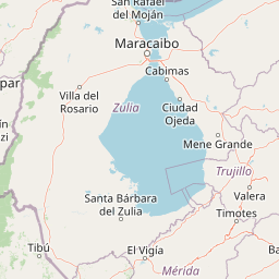
Map view of Ciénaga de Los Olivitos

Use this park location map to pinpoint Ciénaga de Los Olivitos in Venezuela, understand its exact geographic position, and read its mapped placement within the surrounding landscape more clearly.

Pigeon | © OpenStreetMap contributors

Location context for Ciénaga de Los Olivitos

Estado Zulia
Recorded earthquake history

Explore the Historical Earthquake Record for Ciénaga de Los Olivitos

Browse the documented catalogue of seismic activity associated with the Ciénaga de Los Olivitos landscape. This resource provides clear access to historical earthquake data, including magnitude and epicentre distance, allowing for a structured look at the seismic context surrounding this important coastal wetland in Zulia.

Ciénaga de Los Olivitos Earthquake History

Catalogued events

5 events

Strongest magnitude

Magnitude 4.5

Most recent event

Oct 10, 2022

This history includes earthquakes recorded inside the park or within 50 km of its borders

Visual records of tidal mangrove channels, saline flats, and coastal wetland habitats

Ciénaga de Los Olivitos Landscape Photography and Protected Area Scenery

Visual documentation of Ciénaga de Los Olivitos reveals the intricate mosaic of tidal mangrove channels, shallow saline lagoons, and arid coastal terrain defining the protected wetland. Examining these photographs provides direct insight into the natural habitats and characteristic environmental features shaping the southern Caribbean shoreline.

A large flock of pink flamingos flies low over a dark, rippling body of water, with a silhouette of a treeline in the background under a cloudy morning sky.

Park atlas

Compare regional coastal geography and connected wetland reserves

Explore Other Parks Near Ciénaga de Los Olivitos and Surrounding Protected Landscapes

Continue browsing other protected areas near Ciénaga de Los Olivitos to examine related coastal ecosystems and regional wetland geography. Comparing adjacent habitats provides broader context for understanding western Venezuelan conservation landscapes.
National parkLa Guajira
About 132 km away#1 closest

North

Serranía de Macuira National Park: Protected Landscape and Regional Geography Atlas

Explore mapped boundaries of Serranía de Macuira.

Delve into the geography and protected status of Serranía de Macuira National Park, situated in the La Guajira region. This entity offers insight into the mapped terrain and the distribution of protected lands within Colombia. Understand its unique landscape context and its role within a broader geographic atlas.

Area
250 km²
Relief
Mountain
Climate
Arid
Access
Moderate access
Watercolor painting of a beach with cacti, sandy shore, and coastal waters
National parkLa Guajira
About 140 km away#2 closest

Northwest

Bahía Portete, Kaurrele National Natural Park: Mapped Protected Landscape in La Guajira

Explore National Park Geography and Boundaries

Bahía Portete, Kaurrele National Natural Park represents a key protected landscape entity within the La Guajira region of Colombia. This national park's defined geographic scope and mapped protected area status provide a solid foundation for atlas-driven exploration. Understand its role in the regional geography, trace its boundaries, and discover the unique landscape characteristics that define this significant protected territory through structured data.

Area
140.8 km²
Established
2014
Relief
Lowland
Climate
Arid
National parkFalcón State
165 km away#3 closest

Northeast

Médanos de Coro National Park: Venezuela's Unique Arid Landscape and Protected Dune System

Explore the mapped geography of this coastal desert in Falcón State.

Médanos de Coro National Park represents a remarkable protected area within Venezuela's Falcón State, renowned for its spectacular and active sand dune systems. This national park encompasses approximately 91 square kilometers of unique terrain, including large sand formations, salt marshes, and mangrove swamps, contributing to its designation as a key conservation site for arid coastal ecosystems. Users can explore the park's distinctive landscape, understand its geographic context, and discover the patterns of wind-sculpted dunes that define this Venezuelan national park.

Area
91 km²
Established
1974
IUCN
II
Relief
Lowland
National parkZulia
About 174 km away#4 closest

Southwest

Parque Nacional Ciénagas del Catatumbo: Wetland Protected Area and Regional Geography

Expansive marshland terrain in the Zulia state of Venezuela

Parque Nacional Ciénagas del Catatumbo represents an extensive, flat mosaic of freshwater marshes, herbaceous grasslands, and gallery forests along the Catatumbo River delta. As a primary protected area in Zulia, it offers critical insights into lowland wetland ecosystems and the dynamic transition zones bordering Lake Maracaibo.

Area
2,694 km²
Established
1991
IUCN
II
Relief
Lowland
National parkVenezuela
About 175 km away#5 closest

Southwest

Ciénagas del Catatumbo National Park: Venezuela's Freshwater Marsh Protected Landscape

Mapped wetland geography and diverse tropical savanna ecosystems.

Ciénagas del Catatumbo National Park is a vital protected area safeguarding extensive marshland and savanna ecosystems in northwestern Venezuela, specifically within the Lake Maracaibo basin. This national park is recognized for its significant freshwater marsh complex, which supports a rich diversity of bird species and plays a crucial role in the watershed's ecological health. Exploring this park offers a focused discovery of tropical wetland geography and protected landscape features.

IUCN
II
Water
Major water bodies
Wildlife reserveColombia
About 181 km away#6 closest

West

Los Flamencos Sanctuary Wildlife Reserve: Geographic Context and Protected Landscape

Mapped boundaries within Colombia's natural geography.

Los Flamencos Sanctuary is a designated wildlife reserve contributing to the protected landscapes of Colombia. This entry provides a detailed look at its geographic setting and mapped features, crucial for understanding its ecological significance and atlas placement. Explore the protected area's context within the diverse geography of South America, offering a structured perspective for landscape discovery.

Area
0.077 km²
Established
1977
Relief
Lowland
Climate
Tropical
A watercolor painting of a gentle landscape featuring a stream flowing through a grassy meadow bordered by trees with soft pastel colors.
National parkFalcón
About 181 km away#7 closest

East

Parque nacional Juan Crisóstomo Falcón: Karst Geology and Sierra de Falcón Geography

Protected karst mountains, cave systems, and water networks in northern Venezuela.

Parque nacional Juan Crisóstomo Falcón encompasses a distinct limestone landscape within the Sierra de Falcón. This protected area is recognized for vertical sinkholes, sprawling subterranean galleries, and the Fosa de San Luis. As a key water source for the region, the park presents a compact mosaic of varied mountain terrain, encompassing both cloud forest and arid woodland zones across its mountainous expanse.

Area
200 km²
Established
1987
IUCN
II
Relief
Mountain
National parkVenezuela
About 181 km away#8 closest

East

Juan Crisóstomo Falcón National Park: Venezuela's Protected Area and Landscape Geography

Mapped boundaries and regional context for this Venezuelan national park.

Juan Crisóstomo Falcón National Park represents a distinct protected area within Venezuela, offering specific insights into its geographic identity and mapped landscape. This entry facilitates a deeper understanding of the park's protected boundaries and its place within the national and regional atlas of South America. Explore the terrain and natural context that define this significant Venezuelan national park for structured geographic discovery.

Common questions about visiting, size, designation, and location context for Ciénaga de Los Olivitos

Ciénaga de Los Olivitos FAQs for park facts, access, geography, and protected area context

Find quick answers about Ciénaga de Los Olivitos, including protected-area facts, park geography, trail and visitor context, and how the park fits into its surrounding country and regional landscape.
MoriAtlas Explorer

Continue Your Protected Areas Search Across the Global Atlas

Deepen your exploration by continuing the structured search for national parks and protected areas worldwide. Utilize the comprehensive filtering capabilities to compare different conservation landscapes and refine your understanding of global park geography. Discover more about the distribution and characteristics of protected natural areas.

Global natural geography