Why Corredor Biológico Chichinautzin stands out
Chichinautzin is best known for being one of Mexico's earliest and most strategically placed biological corridors, linking two national parks through a continuous belt of protected volcanic landscape. The area stands out for the convergence of pine forest, highland scrub, and volcanic terrain that characterize the southern reaches of the central Mexican highlands. Its role as a buffer zone for Mexico City's southern edge gives the corridor a distinct identity compared to more remote protected areas. Few other Mexican reserves perform the dual function of biodiversity conservation and direct urban pressure buffering at such a scale.
Corredor Biológico Chichinautzin history and protected-area timeline
The Corredor Biológico Chichinautzin was formally decreed on 30 November 1988 as an Área de Protección de Flora y Fauna under Mexican federal law. The designation was part of a broader wave of conservation actions in late 1980s Mexico that sought to lock in protection for biologically and hydrologically important landscapes before urban expansion could threaten them.
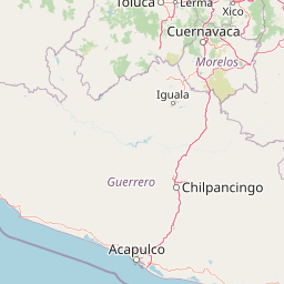
From its inception, the corridor was conceived as more than an isolated reserve. Its boundaries were drawn specifically to encompass the area between El Tepozteco National Park, in northern Morelos, and Lagunas de Zempoala National Park, further to the north. This was a deliberate design choice, establishing the corridor as a connective tissue between existing national parks rather than a freestanding protected zone.
Over the decades since its creation, the corridor has continued to serve as both an ecological refuge and a regulatory boundary for urban growth. Its role as the southern limit of the former Federal District has made it a recurring reference point in regional land-use planning around Mexico City's metropolitan area.
Corredor Biológico Chichinautzin landscape and geographic character
The Chichinautzin corridor occupies a predominantly volcanic landscape, characteristic of the southern end of the Trans-Mexican Volcanic Belt. Dominated by mountains, ridges, and old lava flows, the terrain includes deep ravines and broad plateaus, with elevation changes that create sharp transitions between habitats over short distances.
Pine forests and mixed pine-oak woodlands cover much of the higher elevations, while lower slopes transition into more open scrubland and patches of subtropical vegetation. This layered structure is a defining feature of the area's scenery and contributes significantly to its ecological character. Seasonal streams and small basins interrupt the higher terrain, especially in areas where volcanic ash and weathered rock help retain moisture.
The southern portions of the corridor feel distinctly different from the northern highlands, with warmer, drier vegetation signaling the approach to the Cuernavaca Valley. Volcanic cones and older eruption zones are scattered throughout the area, giving it a strong geological identity that complements its biological importance.
Corredor Biológico Chichinautzin ecosystems, habitats, and plant life
The corridor protects a rich mix of ecosystems typical of central Mexican volcanic highlands. Pine forests, mixed pine-oak forest, and high-elevation scrubland dominate much of the terrain, while warmer lowland environments along the southern portions support subtropical vegetation. These transitions between habitat types occur over relatively short distances, contributing to high local biodiversity.
According to Mexico's National System of Biodiversity Information, the area harbors thousands of recorded species of plants and animals collectively. The habitat mosaic supports a wide range of ecological niches, from mossy montane environments and damp ravines to dry rocky slopes. This diversity of environments within a single continuous protected landscape is one of the area's core conservation strengths.
Corredor Biológico Chichinautzin wildlife and species highlights
The mosaic of habitats within the corridor supports a wide variety of wildlife, ranging from species typical of pine forests and highland scrub to those associated with the warmer valley margins. The protected area functions as a movement corridor for medium and large mammals, allowing populations that would otherwise be isolated by surrounding development to maintain genetic and demographic connectivity between El Tepozteco and Lagunas de Zempoala.
Birdlife is particularly notable across the corridor's elevation gradient. Pine forests support montane bird communities, while the more open scrubland and forest edges host a wider variety of species, including raptors and numerous migratory visitors that benefit from the area's continuous vegetation cover. Beyond birds, the corridor sustains reptile, amphibian, and small mammal communities whose habitat needs are closely tied to the moisture and vegetation dynamics of the volcanic terrain.
Corredor Biológico Chichinautzin conservation status and protection priorities
The Corredor Biológico Chichinautzin is significant from a conservation standpoint because it preserves ecological connectivity in one of the most heavily populated regions of Mexico. Connecting two national parks effectively doubles the functional conservation value of each, allowing ecological processes to operate at a landscape scale rather than being restricted to individual protected patches.
The area also serves as a hydrological buffer, with its volcanic substrate acting as a key recharge zone for the aquifers supplying major cities in Morelos. This integration of biodiversity protection and water resource preservation adds an economic and public-health dimension to the corridor's conservation significance. Its position as a buffer to the Valley of Mexico and the Cuernavaca Valley gives it outsized importance for the environmental quality of millions of residents in nearby urban areas.
Corredor Biológico Chichinautzin cultural meaning and human context
The corridor overlaps with a deeply rooted rural landscape in central Mexico, where traditional communities have long maintained relationships with the surrounding forests and agricultural land. Twelve Morelos municipalities fall within its boundaries, and the area's cultural geography includes small villages, agricultural plots, and longstanding land-use traditions tied to the volcanic terrain.
The corridor also borders Mexico City in its southern delegations, placing it within the environmental edge of one of the largest metropolitan cultural regions in the Americas. This makes the protected area both a rural and a peri-urban cultural space, where rural land-use traditions coexist with the influence of the capital region.
Top sights and standout views in Corredor Biológico Chichinautzin
The corridor's strongest identifying feature is its role as a connective bridge between two national parks, El Tepozteco and Lagunas de Zempoala, forming a continuous protected landscape across the volcanic highlands of central Mexico. Its elevation-driven habitat transitions make it rich in ecological opportunities despite its relatively modest individual footprint.
Equally important is its strategic value as an environmental buffer between Mexico City and the Cuernavaca Valley, providing both water resources and open space for one of the country's most heavily populated regions. Its combination of biodiversity, hydrology, and landscape connectivity gives it a distinct profile among Mexican protected areas.
Best time to visit Corredor Biológico Chichinautzin
Given its altitude range of pine forests and subtropical transitions, the corridor presents different landscape character across seasons. The cooler, dry winter months typically offer clearer weather and good visibility across the volcanic ridges, while the rainy season brings greening landscapes, fuller streams, and active wildlife cycles in the understory. Birdwatching conditions tend to be particularly strong during migration windows, when transient species can pass through the area's elevation gradient.