Mori Atlas logo
National parkDachigam National Park

Discover the mapped boundaries and natural terrain of this Indian national park.

Dachigam National Park: Protected Landscape and Geographic Context in Srinagar District

Dachigam National Park, a protected area situated within the Srinagar district of India, offers a unique landscape for geographic exploration. This page serves as a dedicated entry point for understanding the park's identity as a national park, its place within the regional geography, and its mapped boundaries. Dive into the structured details to grasp the essence of Dachigam National Park's protected land and terrain.

Himalayan national parksKashmir wildlifeEndangered species habitatAlpine meadowsWatershed protectionMountain conservation

Dachigam National Park

National park

Park overview

Structured park overview, official facts, and landscape profile for Dachigam National Park

Dachigam National Park park facts, protected area profile, and essential visitor context

Review the core facts for Dachigam National Park, including designation, size, terrain, visitor scale, habitats, and operating context in one park-focused overview.

About Dachigam National Park

Dachigam National Park represents one of the most significant protected areas in the Kashmir Himalayas, combining critical biodiversity conservation with watershed protection for the Srinagar metropolitan area. The park's dramatic elevation gradient from approximately 1,676 metres to 4,267 metres creates a remarkable diversity of habitats within a relatively compact area, supporting everything from forested lower slopes to alpine grasslands. The Zabarwan Range, which forms the park's geographic backbone, provides a stunning backdrop visible from Srinagar and represents the foothills of the greater Himalayan mountain system. The park's hydrological significance cannot be overstated, as the Dagwan River originates from highland snowmelt and Marsar Lake within the park boundaries, flowing through the protected area before supplying the Sarband reservoir that serves as a critical source of clean drinking water for nearly a million people in the Kashmir Valley. This dual role of biodiversity conservation and water security makes Dachigam uniquely important among Indian national parks.

Quick facts and research context for Dachigam National Park

Dachigam National Park occupies 141 square kilometres in the Zabarwan Range of the western Himalayas, approximately 22 kilometres from Srinagar. The park was first protected in 1910 as a water catchment area and became a national park in 1981. Elevations range from 1,676 to 4,267 metres, creating diverse habitats across alpine meadows, coniferous forests, and rocky terrain. The park serves as a critical watershed, with the Dagwan River feeding the Sarband reservoir that provides drinking water to Srinagar. The park is most renowned for supporting the hangul, or Kashmir stag, a critically endangered species that is the state animal of Jammu and Kashmir.

Protection and recognition

Documenting the terrestrial boundary, management scope, and conservation status since 1981.

Dachigam National Park Protection Status and Terrestrial Designation

Dachigam National Park maintains a documented terrestrial protection status established in 1981 to safeguard its regional wilderness. Analyzing verified geographic datasets provides clear insight into the official designation timeline, terrestrial management scope, and global conservation frameworks.

Protection details

Protection scope
Terrestrial
Designated year
1981
Transboundary protection
No
Park context

Deeper park guide and search-rich context for Dachigam National Park

Dachigam National Park history, landscape, wildlife, and travel context

Explore Dachigam National Park through its history, landscape character, ecosystems, wildlife, conservation priorities, cultural context, and seasonal travel timing in a structured park guide built for atlas discovery and search intent.

Why Dachigam National Park stands out

Dachigam National Park is best known as the primary sanctuary for the hangul, also called the Kashmir stag, one of the rarest and most endangered large mammals in the world. This Critically Endangered deer species finds one of its last remaining strongholds within the park's montane forests and alpine meadows. Beyond the hangul, the park protects a remarkable assembly of Himalayan wildlife including snow leopards, musk deer, Himalayan serow, and both black and brown bears. The park's position in the Zabarwan Range provides access to some of the most scenic Himalayan landscapes accessible from a major city, with its combination of alpine meadows, coniferous forests, and dramatic mountain vistas making it a significant conservation and wilderness area within the Kashmir Valley.

Dachigam National Park history and protected-area timeline

The protection history of Dachigam National Park traces back to 1910, when the area was first reserved under the rule of the Maharaja of Jammu and Kashmir. The initial motivation for protection was pragmatic rather than conservation-focused: the forested catchments of the Zabarwan Range supplied clean water to Srinagar, and the maharaja's administration recognized the importance of maintaining these watersheds against deforestation and degradation. Ten villages that had historically existed within what is now the park were relocated during the early twentieth century, giving the area its name meaning ten villages. This displacement created the conditions for a relatively intact wilderness to persist despite increasing pressure from a growing regional population. The area remained under various forms of protection through the mid-twentieth century before being formally upgraded to national park status in 1981 under India's wildlife protection framework, establishing the current conservation regime that balances ecological preservation with limited sustainable tourism.

Dachigam National Park landscape and geographic character

The physical landscape of Dachigam National Park embodies the dramatic topography characteristic of the western Himalayan foothills. The terrain is defined by steep mountain slopes, rocky cliffs, and deep gullies known locally as nars, which channel seasonal water flow down from the higher elevations. Below the tree line, the mountainsides support dense coniferous forests dominated by broadleaf species, creating a forested character quite different from the higher-elevation pine forests found elsewhere in the Himalayas. Alpine meadows and pastures are interspersed throughout the forest zone, providing seasonal grazing areas and supporting diverse herbaceous vegetation. The upper reaches of the park transition into rocky alpine terrain with limited vegetation, where snow persists for extended periods during winter. Two significant water bodies define the park's hydrology: Marsar Lake sits at high elevation in the interior of the park, and the Dagwan River flows from this lake through the lower regions, following the only motorable road within the park boundaries before eventually joining the Jhelum River system.

Dachigam National Park ecosystems, habitats, and plant life

The ecological character of Dachigam National Park reflects its position in the western Himalayan biodiversity hotspot. The park's elevation range of nearly 2,600 metres supports a vertical zonation of habitats, from subtropical forested slopes through coniferous forest zones to alpine meadows and rock. The forest composition is predominantly broadleaf coniferous, with various species of pine, cedar, and birch occurring at different elevations. These forests grade into alpine pastures during the brief summer growing season, when the meadows explode with colourful wildflowers. The park's water systems, including Marsar Lake and the Dagwan River, add wetland and aquatic habitat diversity to the terrestrial ecosystems. This habitat heterogeneity supports remarkable biodiversity, with the park serving as a microcosm of Himalayan ecology. The protection of these habitats is particularly significant given the intense development pressure on the Kashmir Valley, as Dachigam represents one of the few relatively intact ecological corridors remaining in the region.

Dachigam National Park wildlife and species highlights

Dachigam National Park supports a remarkable assemblage of Himalayan fauna, centred around its most famous resident, the hangul or Kashmir stag. This large deer, the state animal of Jammu and Kashmir, has suffered severe population declines across its historic range, making Dachigam's population critically important for species survival. The park also protects the secretive musk deer, a small Asian ungulate prized for its aromatic musk pod, as well as the Himalayan serow, a goat-antelope adapted to steep mountainous terrain. Predators present include the snow leopard, one of the rarest and most elusive large cats in the world, along with smaller predators such as the leopard cat, jungle cat, and various mustelids including the Himalayan weasel and yellow-throated marten. Bear species include both the Himalayan black bear and the larger Himalayan brown bear. The bird fauna is equally diverse, featuring the brilliantly coloured Himalayan monal pheasant, the distinctive koklass pheasant, and various vulture species including the Himalayan griffon and bearded vulture. The Dagwan River supports introduced trout populations, providing fishing opportunities while also supporting aquatic wildlife including otter.

Dachigam National Park conservation status and protection priorities

Dachigam National Park plays a vital role in conserving some of the most threatened Himalayan biodiversity. The park's primary conservation significance lies in its role as a refuge for the Kashmir stag, a species now confined to isolated populations in the Kashmir Himalayas and neighbouring regions. Conservation efforts within the park focus on protecting habitat connectivity, managing human-wildlife conflict, and maintaining the water catchments that support both wildlife and human communities downstream. The park's proximity to Srinagar creates both opportunities and challenges: the accessible location facilitates conservation monitoring and tourism revenue, but also subjects the area to development pressure and habitat fragmentation. The watershed protection function provides an additional conservation rationale, as maintaining forest cover in the park directly ensures water security for the Kashmir Valley's capital city. This integration of biodiversity conservation with ecosystem service provision makes Dachigam a model for protected area management in mountainous Asian landscapes.

Dachigam National Park cultural meaning and human context

The cultural history of Dachigam National Park is intertwined with the human settlement history of the Kashmir Valley. The name Dachigam derives from the local term for ten villages, reflecting the displacement of these communities in the early twentieth century to create the protected area. While this relocation occurred over a century ago, the cultural landscape bears the imprint of this human history alongside the more recent wilderness conservation values. The park lies within a region of extraordinary cultural significance, as the Kashmir Valley has been a crossroads of South Asian civilization for millennia, with influences from Central Asian, Persian, and South Asian traditions shaping local communities. The nearby city of Srinagar, one of India's oldest continuously inhabited cities, provides the cultural context for understanding Dachigam's role as both a wilderness area and a critical ecological service provider for a historic urban centre.

Top sights and standout views in Dachigam National Park

Dachigam National Park offers visitors a rare opportunity to experience Himalayan wilderness within reach of a major city. The park's most iconic wildlife encounter is the Kashmir stag, which can be spotted in the forested slopes and meadows, particularly during the rutting season when males display their impressive antlers. The scenic drive along the Dagwan River provides access to the park's interior, with views of forested slopes rising toward snow-capped peaks. The combination of alpine meadows blanketed with wildflowers in summer, the dramatic autumn colours of the deciduous forests, and the stark beauty of snow-covered terrain in winter creates a year-round scenic destination. Birdwatchers find particular reward in observing the Himalayan monal, various thrushes, and the spectacular vultures circling on thermal currents. The park's role as a watershed supplying Srinagar adds an ecological dimension to the visitor experience, connecting the landscape to the daily lives of over a million people.

Best time to visit Dachigam National Park

The best time to visit Dachigam National Park depends on what visitors hope to experience. Summer and early autumn, from May through October, offer the most accessible conditions with snow-free roads within the park and pleasant temperatures in the lower elevations. This period coincides with the bloom of alpine flowers in the meadows and provides the best opportunities for wildlife viewing as animals are more active in the warmer months. Autumn brings spectacular forest colour as the broadleaf trees turn golden and red, creating particularly scenic landscapes. Winter visits offer a different experience, with snow-covered terrain and fewer visitors, though some areas may be inaccessible and temperatures drop significantly at higher elevations. The park remains open year-round, but visitors planning trips should be aware that winter conditions in the Himalayas can be challenging and some services may be limited. Spring and early summer provide the most verdant scenery, while late autumn offers clearer skies and excellent visibility for mountain views.
Monthly climate preview

Trace long term temperature averages and monthly precipitation cycles in Srinagar district.

Monthly Climate Normals and Average Weather Patterns in Dachigam National Park

Baseline data measured at over twenty six hundred meters reveals a broad thermal rhythm, with winter averages dropping below freezing and summer peaks reaching near twenty nine degrees. Comparing this complete twelve month profile of temperature and precipitation highlights the distinct transitional climate shifts across this protected mountain terrain.
Annual mean9 °C
-2 °C19 °C
Jan-2°
Feb-1°
Mar
Apr
May14°
Jun18°
Jul19°
Aug18°
Sep15°
Oct10°
Nov
Dec
Warmest month
July

19.1 °C

Coolest month
January

-2.3 °C

Wettest month
March

3.1 mm/day

Driest month
October

0.7 mm/day

Park location guide

Geography guide, regional context, and park location map for Dachigam National Park

Dachigam National Park park geography, regions, and map view in India

Understand where Dachigam National Park sits in India through a broader geographic reading of the surrounding landscape, nearby location context, and its mapped position within the national park landscape.

How Dachigam National Park fits into India

India is a South Asian country bordered by the Indian Ocean, Arabian Sea, and Bay of Bengal. It shares land borders with Pakistan, China, Nepal, Bhutan, Bangladesh, and Myanmar. The country has a population of over 1.4 billion people and operates as a federal parliamentary republic with its capital in New Delhi.

Wider geography shaping Dachigam National Park in India

India occupies the Indian subcontinent in South Asia, bordered by the Arabian Sea to the southwest, the Bay of Bengal to the southeast, and the Indian Ocean to the south. It shares land borders with Pakistan to the west, China, Nepal, and Bhutan to the north, and Bangladesh and Myanmar to the east. The territory also includes the Andaman and Nicobar Islands in the Indian Ocean.

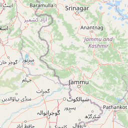
Map view of Dachigam National Park

Use this park location map to pinpoint Dachigam National Park in India, understand its exact geographic position, and read its mapped placement within the surrounding landscape more clearly.

Pigeon | © OpenStreetMap contributors

Location context for Dachigam National Park

Jammu and KashmirSrinagar district
Park atlas

Explore regional park geography and connected protected landscapes surrounding Dachigam National Park in India.

Discover Other National Parks and Protected Areas Near Dachigam National Park

After exploring Dachigam National Park, browse additional protected areas across the Western Himalayan region to compare diverse montane forests, alpine meadows, and critical wildlife habitats. Continue your atlas-style discovery by mapping the regional spread of conservation landscapes and understanding their geographic context alongside Dachigam National Park.
National parkJammu and Kashmir
About 22 km away#1 closest

West

Salim Ali National Park: Mapped Protected Landscape in Jammu and Kashmir

National Park with distinct geographic and regional atlas context.

Salim Ali National Park is a recognized national park situated in the Jammu and Kashmir region. This entry provides specific insights into its designation as a protected area, focusing on its mapped geographic footprint and its contribution to the regional atlas of conservation lands. Understand the park's landscape context and its place within the broader geography of northern India, offering a detailed perspective for geographic exploration.

Area
9.07 km²
Established
1986
IUCN
II
Climate
Temperate
Protected areaJammu and Kashmir
About 31 km away#2 closest

West

Hokersar Protected Area: Wetland Geography and Map Context in Jammu and Kashmir

Migratory bird sanctuary and critical Jhelum basin wetland

Hokersar encompasses a distinct wetland landscape in northwestern India, characterized by shallow water, reed beds, and marshy pastures. As a key node for Palearctic waterbirds in the Kashmir Valley, the reserve provides essential flood-buffering services through its perennial stream network and seasonal snowmelt cycles, making it a focal point for regional ecological study.

Area
13.75 km²
Visitors
500K annual
Relief
Lowland
Climate
Temperate
Nature reserveJammu and Kashmir
About 51 km away#3 closest

Northwest

Wular Lake Nature Reserve: Protected Wetland and Freshwater Geography in the Kashmir Valley

Tectonic freshwater lake and Ramsar-recognized protected area.

Wular Lake stands as one of the largest freshwater bodies in South Asia, characterized by its tectonic origin and its role as a critical component of the Jhelum River catchment. The protected nature reserve landscape currently encompasses a mosaic of open water, reed beds, and muddy shallows that provide habitat for endemic snowtrout and migratory bird populations throughout the Kashmir Valley.

Established
1990
Relief
Lowland
Climate
Temperate
Scope
Terrestrial
National parkPakistan
About 70 km away#4 closest

North

Gurez National Park: Pakistan's Alpine Protected Landscape and Wildlife Habitat

Explore its mapped terrain and regional geographic context.

Gurez National Park stands as a protected national park within Pakistan's breathtaking Himalayan mountain system. This park is crucial for conserving the endangered musk deer and safeguarding a fragile alpine ecosystem characterized by dramatic valleys, steep peaks, and the flowing Kishenganga River. Its relative isolation preserves a unique natural landscape and traditional cultural heritage, making it a point of interest for understanding remote wilderness and conservation efforts within the South Asian atlas.

IUCN
II
National parkGilgit-Baltistan
About 73 km away#5 closest

North

Himalaya National Park: Exploring Its Protected Boundaries and Mountainous Landscape in Gilgit-Baltistan

Mapped protected area within Pakistan's northern mountain region.

Himalaya National Park serves as a significant protected entity within the dramatic geography of Gilgit-Baltistan, Pakistan. This national park offers a focused view of its specific natural terrain and mapped boundaries, contributing to a broader atlas of conservation lands. Users can discover the park's role as a protected landscape, examining its integration within the regional context and understanding its unique geographic characteristics. The focus here is on the park's protected status and its place in the mapped natural environment of Northern Pakistan.

Area
2,263 km²
Established
2021
IUCN
II
Relief
Mountain
National parkGilgit-Baltistan
About 79 km away#6 closest

North

Deosai National Park: A Premier High-Altitude Alpine Wilderness and Protected Landscape in Pakistan

Mapped boundaries and unique terrain within Gilgit-Baltistan's geography.

Deosai National Park is a key protected area in Pakistan's Gilgit-Baltistan region, characterized by its high-altitude alpine meadows and expansive plateau terrain. As a national park, it offers crucial insights into mapped landscapes and regional geography, particularly for understanding conservation efforts in extreme environments. The park's setting provides a unique lens through which to explore the distribution and characteristics of protected lands within the broader atlas of natural landscapes.

Area
3,584 km²
Established
1993
IUCN
Ib
Relief
Highland
National parkBaramulla district
About 93 km away#7 closest

West

Kazinag National Park: Protected Area Geography and Mapped Boundaries in Baramulla District

Explore the regional landscape and terrain of this national park.

Kazinag National Park represents a distinct protected area within India's Baramulla district. This entry provides structured geographic information, focusing on the park's mapped boundaries and its role as a national park. Users can explore its landscape context and understand its specific regional terrain, contributing to a comprehensive atlas view of protected lands.

Area
160 km²
Established
1992
IUCN
II
Relief
Mountain
National parkKishtwar district
About 106 km away#8 closest

Southeast

Kishtwar National Park: Discover Protected Himalayan Wilderness & Geography

Mapped terrain and protected area context in India's Kishtwar district.

Kishtwar National Park is a significant protected landscape situated in the Kishtwar district, India, offering a detailed view of high-altitude Himalayan wilderness. Its dramatic mountainous terrain, from temperate forests to alpine meadows, defines its unique geographic character. Explore the park's mapped boundaries and understand its place within the broader regional geography for comprehensive atlas discovery.

Area
2,190.5 km²
Established
1981
IUCN
II
Relief
Mountain

Common questions about visiting, size, designation, and location context for Dachigam National Park

Dachigam National Park FAQs for park facts, access, geography, and protected area context

Find quick answers about Dachigam National Park, including protected-area facts, park geography, trail and visitor context, and how the park fits into its surrounding country and regional landscape.
MoriAtlas Explorer

Continue Your Protected Areas Search Across the Global Atlas

Deepen your exploration by continuing the structured search for national parks and protected areas worldwide. Utilize the comprehensive filtering capabilities to compare different conservation landscapes and refine your understanding of global park geography. Discover more about the distribution and characteristics of protected natural areas.

Global natural geography