Peaks
Csóványos
938 m

Structured landscape analysis including regional extent, elevation context, and natural features
This geographic profile provides a detailed analysis of Danube-Ipoly National Park, covering its total surface area of 603.14 square kilometers across four administrative regions in Hungary. Explore the complex network of ridges, valleys, and riverine habitats that define the park topography, including specific natural features like the Szép-patak völgye and various mountain ridges.
Related tags
Hungary's ecologically richest national park where mountains, river valleys, and lowlands converge
Danube-Ipoly National Park is one of Hungary's most ecologically diverse protected areas, established in 1997 through the merger of the former Pilis and Börzsöny national parks with portions of the Ipoly River floodplain. The park encompasses a remarkable range of landscapes in northwestern Hungary, spanning parts of Budapest, Pest County, Komárom-Esztergom County, and Fejér County. What makes this park distinctive is its transitional character—where the Danube River, the Pilis Mountains, the Visegrádi Mountains, and the Börzsöny volcanic range meet, creating a complex mosaic of habitats that supports exceptional biodiversity. With approximately 60,314 hectares, it ranks as Hungary's second-largest national park. The area serves as a critical refuge for species that exist nowhere else in the country, and several conservation programs target the park's rare and endangered inhabitants.
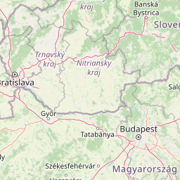
National and county-level placement within Hungary and Turkey
Spatial dimensions and map limits across a 603.14 square kilometer area
Mixed relief classifications and recorded regional landforms
Peaks
938 m
Peaks
756 m
Mountain saddles
590 m
Peaks
376 m
Peaks
480 m
Mountain saddles
490 m
Temperate climate zones, mixed relief, and riverine habitats across the protected terrain
Forest · Wetland · Rivers · Valleys · Hills
Temperate broadleaf forest · Riverine habitat · Wetland
Trace the regional spread of protected landscapes, comparing terrain and conservation zones surrounding Danube-Ipoly National Park.
South

Discover protected landscapes, alkaline lakes, and bird habitats.
Kiskunság National Park in Hungary offers a rare glimpse into the traditional puszta grassland ecosystem, featuring dynamic sand dunes and numerous alkaline lakes. This protected area is vital for migratory bird populations and showcases a distinctive lowland geography shaped by natural processes and pastoral heritage. Explore its scattered territorial units to understand the unique landscape context of the Great Hungarian Plain.

East
Explore mapped boundaries and unique protected landscapes.
Bükk National Park, a protected national park located in Borsod-Abaúj-Zemplén County, Hungary, is recognized for its immense karst landscape. This park offers a significant focus for atlas exploration, with its extensive cave systems, limestone plateaus, and ancient forests providing a unique geographic context for understanding protected areas. Discover the diverse terrain and geological features that define this expansive Hungarian national park.
North

Explore the park's mapped boundaries and regional natural terrain.
Veľká Fatra National Park stands as a distinct protected area, offering critical insights into Slovakia's regional geography and landscape character. This entry provides an atlas-driven perspective on its mapped boundaries and its significance as a national park. Delve into the structured geographic details and protected land context that define Veľká Fatra National Park for comprehensive discovery.
Northeast
Explore mapped boundaries, caves, and endemic flora in Banská Bystrica Region.
Muránska planina National Park represents a significant protected landscape in central Slovakia's Banská Bystrica Region, defined by its extensive karst topography. This national park encompasses a limestone and dolomite plateau rich with geological wonders, including over 150 caves, sinkholes, and karst springs. The unique contrast between the flat plateau surface and the sharp, rocky ravines showcases a dramatic natural terrain. Explore the park's mapped boundaries and its remarkable biodiversity, highlighted by 35 endemic species and rare Tertiary relict flora like Daphne arbuscula, making it a key destination for atlas-based geographic discovery.

North
Explore mapped terrain and regional geographic context.
The Low Tatras National Park represents Slovakia's largest protected area, encompassing the entirety of the Low Tatras mountain range. Its landscape is defined by dramatic altitudinal diversity, from alpine summits like Ďumbier to extensive forest zones and significant karst formations with notable cave systems. This page provides detailed geographic context and map-based discovery for the park's protected boundaries and its ecological significance within the Carpathian region.

Southwest
Volcanic witness mountains and tectonic wetland systems
Lake Balaton represents a unique natural system at the edge of the Carpathian Basin. Defined by its shallow water, volcanic basalt peaks, and complex shoreline erosion patterns, the area supports a vast mosaic of oak forests, vineyard terraces, and protected reed-bed habitats within the Transdanubian region.
Northeast
Karst Landscape & Cave Systems
Explore the protected area of Aggtelek National Park, a UNESCO World Heritage site known for its extensive karst landscapes and significant cave systems. Understand its geographic setting and protected land status.
Northeast
Explore protected terrain and mapped underground wonders in Košice Region.
Slovak Karst National Park offers an unparalleled glimpse into a dynamic karst environment. As a designated national park and UNESCO Biosphere Reserve, it preserves a significant concentration of caves, dramatic limestone formations, and rugged canyons within its territory in southeastern Slovakia. This atlas-focused presentation highlights the park's distinctive geology, mapped landscape features, and its importance as a protected natural area within the broader geography of the Košice Region. Understand the park's surface topography and its world-renowned subterranean realms.
MoriAtlas invites you to delve deeper into the geographic intricacies of Danube-Ipoly National Park. By understanding its unique terrain, mapped boundaries, and transitional ecosystems, you can better contextualize its role within Hungary's protected areas. Continue your atlas exploration to uncover the full scope of its natural landscape and its significance in the broader regional geography.