Mori Atlas logo
National parkDeosai National Park

Discover the mapped boundaries and unique terrain of this Gilgit-Baltistan national park.

Deosai National Park: Pakistan's Expansive High-Altitude Alpine Wilderness and Protected Landscape

Deosai National Park represents a remarkable high-altitude alpine wilderness area situated in Pakistan's Gilgit-Baltistan region. This national park encompasses the Deosai Plains, a vast plateau renowned for its expansive meadows and unique terrain, making it a significant protected landscape for regional geography and atlas exploration. The park's geographic context within the western Himalayas and near the Karakoram Range provides a distinct natural setting for understanding mapped protected areas and their ecological significance.

High-altitude wildernessAlpine plainsHimalayan brown bear conservationKarakoram RangeProtected areaIUCN Category Ib

Deosai National Park

National park

Park overview

Structured park overview, official facts, and landscape profile for Deosai National Park

Deosai National Park park facts, protected area profile, and essential visitor context

Review the core facts for Deosai National Park, including designation, size, terrain, visitor scale, habitats, and operating context in one park-focused overview.

About Deosai National Park

Deosai National Park represents one of Pakistan's most important protected wilderness areas, encompassing a remote and rugged landscape that has long captured the imagination of travelers and naturalists. The park's defining feature is the Deosai Plains, a sweeping alpine plateau that stretches across much of the protected area at elevations exceeding 4,000 metres. This high-altitude environment creates conditions found in few other places on Earth, with harsh winters and brief but productive summers that support a distinctive ecological community. The park's location at the intersection of the Western Himalayas and the Karakoram Range places it within one of the most mountainous regions on the planet, with Nanga Parbat rising to the west as one of the world's most iconic peaks. The area has historically been inaccessible for much of the year due to heavy snowfall, with the Balti people referring to it as Ghbiarsa, meaning 'summer's place,' reflecting its seasonal accessibility. The name Deosai itself derives from the Shina language, combining 'deo' meaning giant and 'sai' meaning shadow, translating to 'the land of the giant' or 'shadow of the giant.' This evocative name reflects both the scale of the landscape and local legends associated with the area.

Quick facts and research context for Deosai National Park

Deosai National Park occupies approximately 358,400 hectares in the western Himalayas of Pakistan, straddling the Skardu and Astore Districts in Gilgit-Baltistan. The park protects the Deosai Plains, a high-altitude alpine ecosystem at an average elevation of 4,114 metres that ranks as the world's second-highest plateau. The park's primary conservation focus is the Himalayan brown bear, a critically endangered species whose population has grown from just 19 individuals in 1993 to 78 by 2022. The area is also notable for its remarkable biodiversity including the Siberian ibex, Snow Leopard, Kashmir Musk Deer, and over 124 species of resident and migratory birds. The park lies adjacent to Nanga Parbat in the Karakoram-West Himalayan region.

Protection and recognition

Verifying terrestrial management scope and official geographic registry data for the alpine plateau

Documented Protection Status and Conservation Profile of Deosai National Park

Researchers and conservationists can trace the documented terrestrial protection status and established administrative boundaries of Deosai National Park. Evaluating verified registry records offers critical geographic context regarding regional management frameworks and official global conservation database alignments.

Protection details

Protection scope
Terrestrial
Transboundary protection
No
Park context

Deeper park guide and search-rich context for Deosai National Park

Deosai National Park history, landscape, wildlife, and travel context

Explore Deosai National Park through its history, landscape character, ecosystems, wildlife, conservation priorities, cultural context, and seasonal travel timing in a structured park guide built for atlas discovery and search intent.

Why Deosai National Park stands out

Deosai National Park is best known for its successful conservation of the critically endangered Himalayan brown bear, which has become the park's flagship species. The park protects one of the highest altitude ecosystems in the world, with the Deosai Plains representing a unique alpine steppe environment that supports remarkable biodiversity in an extreme setting. The area is famous for its spectacular spring wildflower displays and the dramatic transformation of the otherwise stark plateau into a carpet of colorful blooms and butterflies. The park is also recognized for its population of Snow Leopards and as an important habitat for the Lammergeier (bearded vulture) and Golden Eagle.

Deosai National Park history and protected-area timeline

Deosai National Park was established in 1993 with the primary mission of protecting the critically endangered Himalayan brown bear and its habitat. Prior to the park's designation, the brown bear population had been severely depleted by poaching and hunting, with the total population reduced to just 19 individuals by the early 1990s. The establishment of the park represented a critical intervention in the species' survival, and the creation was driven substantially by the efforts of the Himalayan Wildlife Foundation, originally known as the Himalayan Wildlife Project, which played an instrumental role in the park's designation. The Foundation operated park entry check posts and a field research camp for approximately ten years and documented the management framework for handover to the Northern Areas Forest Department in 2006. The conservation success story is notable: the brown bear population has increased from 19 individuals in 1993 to 40 by 2005 and 78 by 2022, representing one of the few instances of successful recovery of a critically endangered large carnivore in South Asia. The park remains on the tentative list of UNESCO World Heritage Sites in Pakistan.

Deosai National Park landscape and geographic character

The Deosai Plains form the core landscape of the national park, comprising an extensive alpine meadow system that stretches across the high plateau. The terrain is characterized by gentle rolling hills and flat valleys between mountain ranges, with an average elevation of 4,114 metres above sea level. Several rivers traverse the plains, with Bara Pani being the largest, flowing through the heart of the park and providing vital water resources for the ecosystem. The surrounding Deosai Mountains frame the plateau, creating a dramatic backdrop of rugged peaks. The geology of the area features severely eroded soils that are coarser in nature and mixed with gravel and stones, while flat areas between mountains contain deeper soils supporting marshy vegetation. In spring, the landscape transforms dramatically as the plains become covered with sweeps of wildflowers, adding vibrant colors to the otherwise austere alpine environment.

Deosai National Park ecosystems, habitats, and plant life

The park protects a representative example of the Karakoram-West Tibetan Plateau alpine steppe eco-region, an ecosystem type found at high elevations across Central Asia. The vegetation consists of alpine meadows and steppe communities adapted to the harsh conditions of high altitude, including numerous species of grasses, sedges, and herbaceous plants. The floral diversity is remarkable, with documented species including Polygonum affine, Thalictrum alpinum, Saxifraga flagellaris, various Artemisia species, and the medicinal plant Saussurea lappa (kuth). The spring season brings spectacular displays of wildflowers and the area is notable for its variety of butterflies. The ecological significance of Deosai extends beyond its borders as a protected area within the broader Himalayan biodiversity hotspot, supporting species communities that are increasingly threatened by climate change and development pressures.

Deosai National Park wildlife and species highlights

Deosai National Park is home to a remarkable assembly of high-altitude wildlife, with the Himalayan brown bear serving as the park's most celebrated species. Once on the brink of local extinction with only 19 individuals remaining in 1993, the bear population has recovered to approximately 78 individuals today, representing one of the most successful large carnivore conservation stories in the region. The park also supports healthy populations of Siberian ibex, which are commonly observed on the surrounding slopes, as well as the elusive Snow Leopard, a species that inhabits the rocky terrain at the park's edges. The Kashmir Musk Deer, Himalayan wolf, and Himalayan marmot round out the notable mammalian fauna. The avifauna is particularly diverse, with over 124 species of resident and migratory birds recorded, including the Golden eagle, Lammergeier (bearded vulture), Himalayan vulture, Laggar falcon, Peregrine falcon, Eurasian kestrel, and the Himalayan snowcock.

Deosai National Park conservation status and protection priorities

The establishment of Deosai National Park represents a significant achievement in Pakistan's conservation landscape, primarily for its successful recovery of the Himalayan brown bear population. The park is designated under IUCN Category Ib as a wilderness area, reflecting its commitment to maintaining natural conditions with minimal human intervention. While hunting and poaching pressures that existed in the 1990s have substantially diminished, the brown bear and other protected species face ongoing threats from climate change and nutritional deficiencies. The park's inclusion on Pakistan's tentative list for UNESCO World Heritage status reflects its outstanding universal value as a protected area. The management transition from the Himalayan Wildlife Foundation to the Northern Areas Forest Department in 2006 marked a shift in administrative oversight, though conservation challenges persist.

Deosai National Park cultural meaning and human context

The Deosai region carries cultural significance that extends beyond its ecological value. Research by French ethnologist Michel Peissel has drawn connections between the ancient Greek historian Herodotus's account of 'gold-digging ants' and the behavior of golden Himalayan marmots on the Deosai plateau, suggesting that local tribes such as the Minaro collected gold dust excavated from marmot burrows. The area has been historically used by the Gujjar-Bakwarwal communities for seasonal grazing, reflecting traditional transhumance practices. The Balti people have long referred to the area as Ghbiarsa, recognizing its character as a summer destination accessible only during the warmer months when the heavy winter snows recede. The travel writer and historian Salman Rashid coined the English moniker 'Land of the Giant' in the early 1990s based on the Shina etymology.

Top sights and standout views in Deosai National Park

Deosai National Park offers visitors an extraordinary high-altitude wilderness experience in one of the most remote and pristine environments in Pakistan. The opportunity to observe the recovered Himalayan brown bear in its natural habitat represents a singular wildlife experience, particularly given the species' precarious status elsewhere in its range. The spring wildflower displays transform the plateau into a vibrant tapestry of colors, while the surrounding mountain scenery provides dramatic backdrops including views toward Nanga Parbat. The avifauna, particularly the large raptors such as Lammergeier and Golden Eagle, attract birdwatchers interested in Himalayan species. The park's status as the second-highest plateau in the world gives it a distinctive character among global protected areas.

Best time to visit Deosai National Park

The optimal time to visit Deosai National Park is during the summer months, typically from June through September, when the park is accessible and the weather is relatively mild for the high-altitude environment. Winter access is essentially impossible due to heavy snowfall that blankets the plateau, which is why the area has traditionally been known as a summer destination (Ghbiarsa in the Balti language). The spring season, particularly late May through early July, offers the spectacular wildflower displays that blanket the plains in color and attract large numbers of butterflies. Summer provides the best opportunities for wildlife viewing, including sightings of Himalayan brown bears and Siberian ibex, while the clearer skies offer excellent visibility of the surrounding mountain peaks.

Monthly climate preview

Analyzing thirty years of baseline temperature and precipitation averages in Gilgit-Baltistan.

Deosai National Park Climate Normals and Monthly Weather Patterns

Long-term measurements at a representative elevation of over 4100 meters show sub-zero mean temperatures for more than half the year, paired with low overall daily precipitation. Examining the complete twelve-month profile provides critical baseline metrics for average minimums, monthly maximums, and seasonal atmospheric transitions.
Annual mean-3 °C
-15 °C10 °C
Jan-15°
Feb-14°
Mar-9°
Apr-3°
May
Jun
Jul10°
Aug10°
Sep
Oct-1°
Nov-7°
Dec-13°
Warmest month
July

10 °C

Coolest month
January

-15.5 °C

Wettest month
February

1.7 mm/day

Driest month
October

0.5 mm/day

Park location guide

Geography guide, regional context, and park location map for Deosai National Park

Deosai National Park park geography, regions, and map view in Pakistan

Understand where Deosai National Park sits in Pakistan through a broader geographic reading of the surrounding landscape, nearby location context, and its mapped position within the national park landscape.

How Deosai National Park fits into Pakistan

Pakistan, officially the Islamic Republic of Pakistan, is a federal parliamentary Islamic republic in South Asia. It is the fifth-most populous country and the 33rd-largest by area. The country gained independence from British India in 1947 and has a diverse history spanning ancient civilizations including Mehrgarh and the Indus Valley Civilisation. Pakistan shares maritime borders with Oman and is bounded by the Arabian Sea, Gulf of Oman, and several neighboring countries.

Wider geography shaping Deosai National Park in Pakistan

Pakistan is located in South Asia, bordered by the Arabian Sea to the south, the Gulf of Oman to the southwest, and shares land borders with India to the east, Afghanistan to the west, Iran to the southwest, and China to the northeast. The country also shares a maritime border with Oman in the Gulf of Oman. The Wakhan Corridor in Afghanistan separates Pakistan from Tajikistan in the northwest.

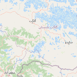
Map view of Deosai National Park

Use this park location map to pinpoint Deosai National Park in Pakistan, understand its exact geographic position, and read its mapped placement within the surrounding landscape more clearly.

Pigeon | © OpenStreetMap contributors

Location context for Deosai National Park

Gilgit-Baltistan
Natural feature types

Browse the Complete Collection of Deosai National Park Natural Features

Examine the specific landforms, watercourses, and mountain features that define the Deosai National Park ecosystem. MoriAtlas provides detailed geographic context for these natural elements, supporting deeper exploration of this high-altitude alpine environment.
Recorded earthquake history

Review Recorded Earthquake History and Seismic Data for Deosai National Park

Access a historical collection of seismic records near the Deosai Plains. MoriAtlas provides a clear, data-driven perspective on past earthquake activity for this region, allowing for informed exploration of the area's geological past through standardized event documentation.

Deosai National Park Earthquake History

Catalogued events

41 events

Strongest magnitude

Magnitude 4.9

Most recent event

Sep 14, 2025

This history includes earthquakes recorded inside the park or within 50 km of its borders

Park atlas

Browse nearby alpine wilderness areas and high-altitude protected landscapes across the Karakoram Range and Gilgit-Baltistan region.

Explore Other National Parks Near Deosai National Park, Comparing Protected Areas in Pakistan

Continue your discovery from Deosai National Park to explore other national parks and protected areas within Pakistan's high-altitude wilderness, tracing alpine ecosystems and significant conservation landscapes. Gain geographic context by comparing terrain, wildlife habitats, and conservation priorities across the broader Himalayan and Karakoram ranges.
National parkGilgit-Baltistan
About 15 km away#1 closest

Southwest

Himalaya National Park: Exploring Its Protected Boundaries and Mountainous Landscape in Gilgit-Baltistan

Mapped protected area within Pakistan's northern mountain region.

Himalaya National Park serves as a significant protected entity within the dramatic geography of Gilgit-Baltistan, Pakistan. This national park offers a focused view of its specific natural terrain and mapped boundaries, contributing to a broader atlas of conservation lands. Users can discover the park's role as a protected landscape, examining its integration within the regional context and understanding its unique geographic characteristics. The focus here is on the park's protected status and its place in the mapped natural environment of Northern Pakistan.

Area
2,263 km²
Established
2021
IUCN
II
Relief
Mountain
National parkPakistan
About 39 km away#2 closest

Southwest

Gurez National Park: Pakistan's Alpine Protected Landscape and Wildlife Habitat

Explore its mapped terrain and regional geographic context.

Gurez National Park stands as a protected national park within Pakistan's breathtaking Himalayan mountain system. This park is crucial for conserving the endangered musk deer and safeguarding a fragile alpine ecosystem characterized by dramatic valleys, steep peaks, and the flowing Kishenganga River. Its relative isolation preserves a unique natural landscape and traditional cultural heritage, making it a point of interest for understanding remote wilderness and conservation efforts within the South Asian atlas.

IUCN
II
National parkGilgit-Baltistan
About 59 km away#3 closest

West

Nanga Parbat National Park: Protected Himalayan Landscape and Geographic Atlas

Explore mapped boundaries and alpine terrain in Gilgit-Baltistan.

Nanga Parbat National Park is a vast protected area defined by its spectacular Himalayan setting and dramatic alpine geography within Gilgit-Baltistan, Pakistan. As a national park, it safeguards the immense Nanga Parbat massif, its surrounding glaciers, and diverse altitudinal landscapes. This page offers an atlas perspective for understanding the park's geographic scope, its mapped natural features, and its significance as a protected mountain wilderness.

Area
1,785.61 km²
Established
2021
IUCN
II
Relief
Mountain
Wildlife reserveGilgit-Baltistan
About 74 km away#4 closest

Northwest

Astore Wildlife Sanctuary: Protected Alpine and Mountain Landscapes in Gilgit-Baltistan

High-altitude conservation area between Nanga Parbat and Deosai

Astore Wildlife Sanctuary encompasses over 400 square kilometers of diverse mountain terrain in Pakistan. Spanning from temperate river valleys to glaciated alpine peaks, the sanctuary safeguards critical habitats for threatened species like the Astor markhor and the Himalayan brown bear. Use this geographic atlas data to understand its unique position within the western Karakoram borderlands.

Area
414.72 km²
Established
1975
Relief
Mountain
Climate
Alpine
National parkSrinagar district
About 79 km away#5 closest

South

Dachigam National Park: Protected Landscape Atlas and Geographic Context in Srinagar District

Mapped boundaries and natural terrain within India's national park system.

Gain insight into Dachigam National Park, a significant protected area located in the Srinagar district. This page provides detailed geographic context and an atlas-style view of its protected landscape. Understand its specific role as a national park and explore its mapped features, contributing to a comprehensive understanding of India's natural territories.

Area
141 km²
Established
1910
IUCN
II
Relief
Mountain
Nature reserveJammu and Kashmir
About 81 km away#6 closest

Southwest

Wular Lake Nature Reserve: Protected Wetland and Freshwater Geography in the Kashmir Valley

Tectonic freshwater lake and Ramsar-recognized protected area.

Wular Lake stands as one of the largest freshwater bodies in South Asia, characterized by its tectonic origin and its role as a critical component of the Jhelum River catchment. The protected nature reserve landscape currently encompasses a mosaic of open water, reed beds, and muddy shallows that provide habitat for endemic snowtrout and migratory bird populations throughout the Kashmir Valley.

Established
1990
Relief
Lowland
Climate
Temperate
Scope
Terrestrial
National parkAzad Kashmir
About 86 km away#7 closest

West

Ghamot National Park: Pakistan National Park Atlas and Protected Landscape

Explore mapped boundaries and regional geography in Azad Kashmir.

Ghamot National Park represents a cornerstone for protected area exploration in Pakistan, situated within the dramatic mountainous terrain of Azad Kashmir. As a national park, it is recognized for its critical function as a wildlife corridor, especially for the survival of the Himalayan Brown Bear, and harbors diverse avian populations. This page offers detailed insight into its geographic context and its significance within a broader regional conservation strategy, providing rich data for atlas-based discovery.

Established
2004
IUCN
II
Relief
Mountain
Access
Remote access
National parkJammu and Kashmir
About 94 km away#8 closest

Southwest

Salim Ali National Park: Mapped Protected Landscape in Jammu and Kashmir

National Park with distinct geographic and regional atlas context.

Salim Ali National Park is a recognized national park situated in the Jammu and Kashmir region. This entry provides specific insights into its designation as a protected area, focusing on its mapped geographic footprint and its contribution to the regional atlas of conservation lands. Understand the park's landscape context and its place within the broader geography of northern India, offering a detailed perspective for geographic exploration.

Area
9.07 km²
Established
1986
IUCN
II
Climate
Temperate

Common questions about visiting, size, designation, and location context for Deosai National Park

Deosai National Park FAQs for park facts, access, geography, and protected area context

Find quick answers about Deosai National Park, including protected-area facts, park geography, trail and visitor context, and how the park fits into its surrounding country and regional landscape.
MoriAtlas Explorer

Continue Your Protected Areas Search Across the Global Atlas

Deepen your exploration by continuing the structured search for national parks and protected areas worldwide. Utilize the comprehensive filtering capabilities to compare different conservation landscapes and refine your understanding of global park geography. Discover more about the distribution and characteristics of protected natural areas.

Global natural geography