

Mori Atlas logo
National parkNanga Parbat National Park

Discover the mapped boundaries and dramatic alpine terrain of this iconic national park.

Nanga Parbat National Park: Himalayan Protected Landscape and Geography in Gilgit-Baltistan

Nanga Parbat National Park represents a significant protected area within Pakistan's Gilgit-Baltistan region, safeguarding the dramatic geography of the central Karakoram. This national park encompasses the legendary Nanga Parbat massif, offering users an atlas-centric view of its immense scale, glacial features, and steep alpine terrain. Explore the park's vast protected landscape, understand its regional geographic context, and discover its mapped natural boundaries.

mountain wildernessKarakoramalpine meadowsconiferous forestsHimalayan peakswildlife conservation

Nanga Parbat National Park

National park

Park overview

Structured park overview, official facts, and landscape profile for Nanga Parbat National Park

Nanga Parbat National Park park facts, protected area profile, and essential visitor context

Review the core facts for Nanga Parbat National Park, including designation, size, terrain, visitor scale, habitats, and operating context in one park-focused overview.

About Nanga Parbat National Park

Nanga Parbat National Park represents Pakistan's commitment to preserving its high-altitude mountain ecosystems in the Karakoram region. The park's establishment in 2021 marked an important expansion of Pakistan's protected area network, providing formal conservation status to a landscape of exceptional natural beauty and ecological significance. The protected area encompasses a complex of towering peaks, glacier-fed valleys, and forested slopes that define the eastern Karakoram.

The park's location at the junction of several ecological zones contributes to its biological diversity. The dry temperate coniferous forests that cloak the lower slopes support species adapted to the continental climate of inner Himalayan valleys, while the alpine meadows above provide seasonal grazing habitat for mountain ungulates. The steep terrain and inaccessible nature of much of the park has helped preserve relatively intact ecosystems despite increasing human pressure in surrounding areas.

Nanga Parbat itself has long captured the imagination of explorers and mountaineers. Known locally as the 'Killer Mountain' due to the many fatalities on its slopes during early climbing attempts, it was first successfully summited in 1953 by Hermann Buhl of Austria. The mountain's dramatic north face, known as the Rupal Face, rises some 4,500 meters above its base, making it one of the steepest faces in the world. This mountaineering heritage adds cultural significance to the park's natural values.

Quick facts and research context for Nanga Parbat National Park

Nanga Parbat National Park lies in northern Pakistan's Gilgit-Baltistan region, spanning the Diamer and Astore districts. The park was established in 2021 and covers 1,785.61 square kilometers of mountainous terrain. Its focal point is Nanga Parbat, the ninth-highest mountain globally, which rises dramatically within the protected boundary. The terrain ranges from dry temperate coniferous forests at lower elevations through alpine meadows to permanent snow and glaciated peaks. The park contains several notable geographic features including Rupal Peak, Mazeno Ridge, Fairy Meadows, Laila Peak, Shaigiri Peak, and Rama Lake.

Protection and recognition

Documenting terrestrial boundaries, official reserve frameworks, and international designation records.

Nanga Parbat National Park Protection Status and Conservation Designation

Map out the official designation history and terrestrial protection status governing Nanga Parbat National Park. Understanding these documented conservation frameworks and terrestrial boundaries provides crucial geographic context for the surrounding mountain landscape.

Protection details

Protection scope
Terrestrial
Park context

Deeper park guide and search-rich context for Nanga Parbat National Park

Nanga Parbat National Park history, landscape, wildlife, and travel context

Explore Nanga Parbat National Park through its history, landscape character, ecosystems, wildlife, conservation priorities, cultural context, and seasonal travel timing in a structured park guide built for atlas discovery and search intent.

Why Nanga Parbat National Park stands out

Nanga Parbat National Park is best known for protecting one of the world's most iconic Himalayan peaks and the dramatic mountain landscape surrounding it. The park encompasses the Nanga Parbat massif, a legendary destination for mountaineering that has historically been one of the most challenging and deadly of the eight-thousanders to climb. Beyond its mountaineering significance, the park is recognized for its population of Markhor, the large wild goat species that is Pakistan's national animal, as well as for preserving significant habitat for Himalayan brown bears and Kashmir musk deer in a region where these species face considerable conservation pressure.

Nanga Parbat National Park history and protected-area timeline

Nanga Parbat National Park was established in 2021 as part of Pakistan's efforts to expand and strengthen its network of protected areas. The creation of the park followed recognition of the region's ecological importance and the need to formalize conservation measures for its distinctive mountain ecosystems. Prior to formal protected area status, the area had been managed under various wildlife protection regulations, but the national park designation provided enhanced legal framework for conservation and management.

The establishment of the park came during a period of increased attention to Pakistan's northern mountain regions, which face pressures from climate change, infrastructure development, and shifting land-use patterns. Formal protection for the Nanga Parbat region had been under discussion for several years before the final designation was made. The park encompasses territory that had previously been partially included in other administrative conservation categories, bringing together previously fragmented protections under a single coherent framework.

Nanga Parbat National Park landscape and geographic character

The landscape of Nanga Parbat National Park is defined by the towering peaks and deep valleys of the central Karakoram. The park encompasses dramatic alpine terrain characterized by steep-walled valleys, glaciated peaks, and extensive rock and ice formations. Nanga Parbat itself rises as a massive pyramidal peak, its massive north face presenting one of the most imposing mountain walls in the world. The Rupal Face, on the southern side of the mountain, drops approximately 4,500 meters from summit to base, creating a landscape of extraordinary vertical relief.

The park contains multiple notable peaks beyond Nanga Parbat, including Rupal Peak, Laila Peak, and Shaigiri, which contribute to the spectacular mountain scenery. The Mazeno Ridge, one of the longest high-altitude ridges in the Karakoram, traverses the park's eastern portion. Between the peaks lie glacial valleys and meadows such as Fairy Meadows, a renowned alpine meadow area that has become a destination for visitors seeking to experience the mountain landscape. Rama Lake, a glacial lake in the park, adds to the diversity of landscape features. The terrain ranges from around 2,000 meters elevation in the valley bottoms to over 8,000 meters at the summit of Nanga Parbat.

Nanga Parbat National Park ecosystems, habitats, and plant life

The nature of Nanga Parbat National Park reflects the park's position in the inner Himalayan zone, where continental climate patterns create distinctive vegetation communities. The park protects dry temperate coniferous forests dominated by species including spruce, blue pine, fir, juniper, and birch. These forests occur on slopes and in valleys at lower elevations, providing habitat for wildlife and playing important watershed functions. Above the tree line, alpine meadows stretch across mountain slopes during the summer months, supporting grazing wildlife and providing seasonal habitat.

The vegetation zonation reflects the harsh continental climate of the inner Himalaya, where precipitation is relatively low and temperatures show extreme seasonal variation. The transition from forest through shrubland to alpine meadow creates a mosaic of habitats that supports diverse plant communities. Sea buckthorn occurs in riparian areas and lower slopes, adding to the botanical character of the park. The combination of forest and open alpine habitats across a dramatic elevation gradient creates conditions for ecological diversity.

Nanga Parbat National Park wildlife and species highlights

Nanga Parbat National Park supports a notable assembly of wildlife species adapted to high-altitude mountain environments. The park provides habitat for several mammal species of conservation significance in the region. The Markhor, Pakistan's national animal and a species listed as near threatened, inhabits the steep rocky terrain and is among the most distinctive large mammals found within the park. Himalayan brown bears, though rarely seen, occupy the forested areas and alpine zones, representing a population at the southern edge of the species' range in the western Himalaya.

Other notable mammals include the Kashmir musk deer, found in forest and scrub habitats, the Ladakh urial inhabiting open slopes, Himalayan ibex navigating the craggy terrain, and Himalayan wolves patrolling the higher elevations. Himalayan marmots are common in alpine meadows where they inhabit burrow systems. The avifauna includes the colorful Monal pheasant, various corvid species such as magpies, and the Himalayan Griffon vulture soaring on thermal currents. This assemblage of species reflects the park's role in preserving mountain ecosystem integrity.

Nanga Parbat National Park conservation status and protection priorities

Nanga Parbat National Park serves important conservation functions in a region where mountain ecosystems face multiple pressures. The protected area preserves habitat for species of regional and global concern, including populations of Markhor and Himalayan brown bear that have declining or fragmented distributions. The park's establishment formalized protection for an area that had previously lacked comprehensive conservation status, bringing together diverse terrain under unified management.

The conservation significance of the park extends beyond individual species to the preservation of entire ecological communities. The dry temperate forest ecosystems, alpine meadows, and glacial landscapes represent habitats that are poorly represented in Pakistan's protected area network. The park's elevation gradient from valley to summit encompasses multiple ecological zones, providing resilience and supporting species that require different habitats seasonally. Management of the park must balance conservation objectives with the traditional livelihoods of local communities who have historically used the area for grazing and other purposes.

Nanga Parbat National Park cultural meaning and human context

The Nanga Parbat region has been home to local communities for generations, with villages in the surrounding valleys supporting populations whose lives are intertwined with the mountain environment. The Diamer and Astore districts contain communities with deep cultural connections to the landscape, including traditional practices of seasonal grazing in high meadows and reliance on natural resources. These communities have historically navigated the challenges and opportunities presented by the mountain environment.

The region holds significance beyond its ecological values as an area of cultural identity for the people of Gilgit-Baltistan. Local communities possess traditional knowledge of the mountain landscape, wildlife behavior, and seasonal patterns that reflects generations of interaction with the environment. While the park itself is relatively new, the cultural landscape surrounding it has been inhabited and used for centuries, creating a context where conservation efforts must consider traditional land-use practices and community livelihoods.

Top sights and standout views in Nanga Parbat National Park

The defining highlight of Nanga Parbat National Park is the mountain itself, one of the world's most famous peaks and the ninth-highest globally, whose dramatic presence dominates the protected area. The park offers the rare opportunity to experience Himalayan mountain landscapes of exceptional grandeur, with views of massive rock faces, glaciers, and alpine meadows that define one of the world's great mountain environments. Wildlife viewing opportunities include the chance to observe Markhor in their natural mountain habitat, along with ibex, Himalayan brown bears, and diverse birdlife. The combination of mountaineering heritage, ecological significance, and spectacular scenery makes this park a destination of international importance.

Best time to visit Nanga Parbat National Park

The best time to visit Nanga Parbat National Park is during the summer months from May through September when weather conditions are most favorable for travel and exploration. During this period, mountain trails are accessible, alpine meadows are lush with vegetation, and wildlife is more readily observable as animals move to higher elevations. The winter months bring heavy snowfall that makes much of the park inaccessible and creates dangerous conditions for travel. Spring and autumn offer transitional conditions with variable weather. Visitors should be prepared for the extreme altitude and variable mountain weather regardless of season, and should be aware that access to some areas may be restricted or subject to local conditions.
Monthly climate preview

Long term weather by month averages for the high altitude terrains of Gilgit Baltistan

Nanga Parbat National Park Climate Normals and Monthly Weather

Long term records at the representative mountain coordinate reveal sub zero winter averages and mild summers alongside light year round precipitation. Accessing the complete twelve month profile provides the detailed temperature spreads and daily precipitation averages needed for deeper geographical analysis.
Annual mean-1 °C
-14 °C11 °C
Jan-14°
Feb-12°
Mar-8°
Apr-2°
May
Jun
Jul11°
Aug11°
Sep
Oct
Nov-6°
Dec-11°
Warmest month
July

11.3 °C

Coolest month
January

-13.8 °C

Wettest month
March

2.5 mm/day

Driest month
October

0.6 mm/day

Park location guide

Geography guide, regional context, and park location map for Nanga Parbat National Park

Nanga Parbat National Park park geography, regions, and map view in Pakistan

Understand where Nanga Parbat National Park sits in Pakistan through a broader geographic reading of the surrounding landscape, nearby location context, and its mapped position within the national park landscape.

How Nanga Parbat National Park fits into Pakistan

Pakistan, officially the Islamic Republic of Pakistan, is a federal parliamentary Islamic republic in South Asia. It is the fifth-most populous country and the 33rd-largest by area. The country gained independence from British India in 1947 and has a diverse history spanning ancient civilizations including Mehrgarh and the Indus Valley Civilisation. Pakistan shares maritime borders with Oman and is bounded by the Arabian Sea, Gulf of Oman, and several neighboring countries.

Wider geography shaping Nanga Parbat National Park in Pakistan

Pakistan is located in South Asia, bordered by the Arabian Sea to the south, the Gulf of Oman to the southwest, and shares land borders with India to the east, Afghanistan to the west, Iran to the southwest, and China to the northeast. The country also shares a maritime border with Oman in the Gulf of Oman. The Wakhan Corridor in Afghanistan separates Pakistan from Tajikistan in the northwest.

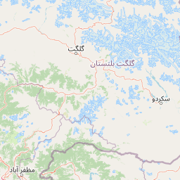
Map view of Nanga Parbat National Park

Use this park location map to pinpoint Nanga Parbat National Park in Pakistan, understand its exact geographic position, and read its mapped placement within the surrounding landscape more clearly.

Pigeon | © OpenStreetMap contributors

Location context for Nanga Parbat National Park

Astore DistrictDiamer DistrictGilgit-Baltistan
Park atlas

Discover neighboring protected areas, comparing their unique mountain geography and regional conservation efforts.

Explore National Parks and Protected Areas near Nanga Parbat National Park in the Karakoram Himalayas

Explore other protected areas across Pakistan's Karakoram range, comparing their mountain landscapes, glacial features, and critical wildlife conservation efforts. Discover additional national parks and protected areas to trace the regional spread of conservation, gaining valuable geographic context for atlas-style exploration and comparison across the Himalayas.
National parkAzad Kashmir
About 36 km away#1 closest

Southwest

Ghamot National Park: Pakistan National Park Atlas and Protected Landscape

Explore mapped boundaries and regional geography in Azad Kashmir.

Ghamot National Park represents a cornerstone for protected area exploration in Pakistan, situated within the dramatic mountainous terrain of Azad Kashmir. As a national park, it is recognized for its critical function as a wildlife corridor, especially for the survival of the Himalayan Brown Bear, and harbors diverse avian populations. This page offers detailed insight into its geographic context and its significance within a broader regional conservation strategy, providing rich data for atlas-based discovery.

Established
2004
IUCN
II
Relief
Mountain
Access
Remote access
National parkPakistan
About 46 km away#2 closest

West

Lulusar-Dudipatsar National Park: Pakistan's Dramatic Western Himalayan Protected Area

Explore alpine lakes, mountain scenery, and protected landscape geography.

Lulusar-Dudipatsar National Park stands as a remarkable protected landscape within Pakistan's Western Himalayas. The park's geography is defined by towering peaks and a series of pristine glacial lakes, including the iconic Dudipatsar and Lulusar lakes. Users can explore its mapped terrain and understand its significance as a high-altitude ecosystem and a key component of Pakistan's protected areas network.

Established
2003
IUCN
II
Relief
Mountain
Climate
Alpine
National parkPakistan
About 53 km away#3 closest

Southeast

Gurez National Park: Pakistan's Alpine Protected Landscape and Wildlife Habitat

Explore its mapped terrain and regional geographic context.

Gurez National Park stands as a protected national park within Pakistan's breathtaking Himalayan mountain system. This park is crucial for conserving the endangered musk deer and safeguarding a fragile alpine ecosystem characterized by dramatic valleys, steep peaks, and the flowing Kishenganga River. Its relative isolation preserves a unique natural landscape and traditional cultural heritage, making it a point of interest for understanding remote wilderness and conservation efforts within the South Asian atlas.

IUCN
II
Wildlife reserveGilgit-Baltistan
About 53 km away#4 closest

North

Astore Wildlife Sanctuary: Protected Alpine and Mountain Landscapes in Gilgit-Baltistan

High-altitude conservation area between Nanga Parbat and Deosai

Astore Wildlife Sanctuary encompasses over 400 square kilometers of diverse mountain terrain in Pakistan. Spanning from temperate river valleys to glaciated alpine peaks, the sanctuary safeguards critical habitats for threatened species like the Astor markhor and the Himalayan brown bear. Use this geographic atlas data to understand its unique position within the western Karakoram borderlands.

Area
414.72 km²
Established
1975
Relief
Mountain
Climate
Alpine
National parkGilgit-Baltistan
About 59 km away#5 closest

East

Deosai National Park: A Premier High-Altitude Alpine Wilderness and Protected Landscape in Pakistan

Mapped boundaries and unique terrain within Gilgit-Baltistan's geography.

Deosai National Park is a key protected area in Pakistan's Gilgit-Baltistan region, characterized by its high-altitude alpine meadows and expansive plateau terrain. As a national park, it offers crucial insights into mapped landscapes and regional geography, particularly for understanding conservation efforts in extreme environments. The park's setting provides a unique lens through which to explore the distribution and characteristics of protected lands within the broader atlas of natural landscapes.

Area
3,584 km²
Established
1993
IUCN
Ib
Relief
Highland
National parkGilgit-Baltistan
About 64 km away#6 closest

Southeast

Himalaya National Park: Exploring Its Protected Boundaries and Mountainous Landscape in Gilgit-Baltistan

Mapped protected area within Pakistan's northern mountain region.

Himalaya National Park serves as a significant protected entity within the dramatic geography of Gilgit-Baltistan, Pakistan. This national park offers a focused view of its specific natural terrain and mapped boundaries, contributing to a broader atlas of conservation lands. Users can discover the park's role as a protected landscape, examining its integration within the regional context and understanding its unique geographic characteristics. The focus here is on the park's protected status and its place in the mapped natural environment of Northern Pakistan.

Area
2,263 km²
Established
2021
IUCN
II
Relief
Mountain
National parkKhyber Pakhtunkhwa
About 82 km away#7 closest

Southwest

Saiful Muluk National Park: Mapped Protected Landscape and Alpine Terrain in Pakistan

Discover the geography and protected boundaries of this Himalayan national park.

Saiful Muluk National Park in Khyber Pakhtunkhwa, Pakistan, is a key protected area characterized by its stunning alpine lake and dramatic Himalayan topography. This entry details the park's geographic scope, mapped landscape features, and its role as a critical national park. Understand the unique subalpine forests and meadow habitats that define this mountainous region and its protected status.

Area
880 km²
Established
2003
IUCN
II
Relief
Mountain
Nature reserveJammu and Kashmir
About 88 km away#8 closest

South

Wular Lake Nature Reserve: Protected Wetland and Freshwater Geography in the Kashmir Valley

Tectonic freshwater lake and Ramsar-recognized protected area.

Wular Lake stands as one of the largest freshwater bodies in South Asia, characterized by its tectonic origin and its role as a critical component of the Jhelum River catchment. The protected nature reserve landscape currently encompasses a mosaic of open water, reed beds, and muddy shallows that provide habitat for endemic snowtrout and migratory bird populations throughout the Kashmir Valley.

Established
1990
Relief
Lowland
Climate
Temperate
Scope
Terrestrial

Common questions about visiting, size, designation, and location context for Nanga Parbat National Park

Nanga Parbat National Park FAQs for park facts, access, geography, and protected area context

Find quick answers about Nanga Parbat National Park, including protected-area facts, park geography, trail and visitor context, and how the park fits into its surrounding country and regional landscape.
MoriAtlas Explorer

Continue Your Protected Areas Search Across the Global Atlas

Deepen your exploration by continuing the structured search for national parks and protected areas worldwide. Utilize the comprehensive filtering capabilities to compare different conservation landscapes and refine your understanding of global park geography. Discover more about the distribution and characteristics of protected natural areas.

Global natural geography
