
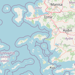
Beaches
Park geography
Detailed map boundaries, coastal terrain, and environmental landscape classifications
Geographic Profile of Dilek Peninsula-Büyük Menderes Delta National Park in Aydın Province, Turkey
Examine the structured geographic data for Dilek Peninsula-Büyük Menderes Delta National Park. This profile details the mountain peaks, coastal features, riverine systems, and forest cover defining the park's physical extent within Aydın Province. Access map-derived measurements including perimeter length, total area, and elevational reach across the Mediterranean landscape.
Related tags
Mediterranean national parksWetland reservesBirdwatching hotspotsCoastal protected areasMountainous terrain
Turkey's biodiversity hotspot where Aegean mountains meet a Ramsar-protected wetland delta
Dilek Peninsula-Büyük Menderes Delta National Park
Dilek Peninsula-Büyük Menderes Delta National Park is one of Turkey's most ecologically significant protected areas, located in the Aegean Region near the coastal town of Kuşadası in Aydın Province. Established on May 19, 1966, the park encompasses the entire Dilek Peninsula and the expansive Büyük Menderes River delta, spanning approximately 27,598 hectares. The park is distinguished by its remarkable biogeographic position where Mediterranean maquis shrubland meets one of Turkey's most important wetland systems. Mount Mycale, the peninsula's highest peak at 1,237 meters, rises dramatically above the narrow Mycale Strait that separates the protected area from the Greek island of Samos. The national park holds international protection status under the Ramsar Convention, the Berne Convention, the Rio Convention on Biological Diversity, and the Barcelona Convention, recognizing its exceptional biodiversity and conservation value.
- Location
- Turkey
- Park type
- National park
- Established
- 1966
- Area
- 276 km²
- Highest point
- 1,237 m
Location overview
Coastal and marine geography within Turkey's Aydın Province
Geographic Profile of Dilek Peninsula,Büyük Menderes Delta National Park
Dilek Peninsula,Büyük Menderes Delta National Park is situated within Turkey's Aydın Province. Coastal and marine designations define its administrative status as a key regional intersection of land and sea.
- Countries
- Turkey
- Regions
- Aydın Province
- Primary location
- Aydın Province
- Geographic setting
- Coastal · Marine
Boundary and coordinates
Spatial dimensions and mapped limits across 275.98 square kilometers.
Geographic Boundaries of Dilek Peninsula-Büyük Menderes Delta National Park
The mapped outline shows the spatial layout of Dilek Peninsula-Büyük Menderes Delta National Park. Geographic datasets detail the estimated area, center coordinates, and spatial spans across the protected region.
- Boundary area
- 281 km²
- Boundary perimeter
- 112.6 km
- Northernmost point
- 37.7162° N
- Southernmost point
- 37.449° N
- Easternmost point
- 27.2558° E
- Westernmost point
- 26.9944° E
- Geographic centre
- 37.6108° N, 27.158° E
- North–south span
- 29.7 km
- East–west span
- 23.1 km
Elevation and terrain
Mountain relief statistics and recorded natural features across protected boundaries
Dilek Peninsula-Büyük Menderes Delta National Park Terrain and Elevation Profile
Elevation summary metrics outline the park terrain, including a recorded high point of 1237 meters above sea level. Mapped natural feature cards provide names, types, measurements, and spatial relationships for identified elements.
- Highest point
- 1,237 m
Selected named natural features
Peninsulas
Dilek Peninsula
Straits
Dilek Geçidi
Islands
Su Adası
Beaches
İçmeler Koyu Plajı
Beaches
Kavaklı Burun
Environmental setting
Recorded landscape features, habitat types, and climate zones across the park terrain.
Environmental Classifications of Dilek Peninsula-Büyük Menderes Delta National Park
Mediterranean climate zones, forest cover, and dominant water presences frame the physical settings recorded across the terrain. Stored categories link directly to related atlas destinations for broader regional exploration.
- Relief
- Mountain
- Climate
- Mediterranean
- Water
- Water-dominated
- Forest cover
- Mostly forested
- Seasonality
- Seasonal
Landscape features
Mountains · Valleys · Canyon · Forest · Wetland · Rivers · Coast · Beach · Cave
Habitat types
Mediterranean forest · Wetland · Riverine habitat · Coastal habitat · Marine habitat · Shrubland · Montane forest
Park atlas
Explore nearby protected areas and compare diverse landscapes across Aydın Province and the broader Aegean Region.
Discover Other National Parks and Protected Areas Near Dilek Peninsula-Büyük Menderes Delta National Park
Browse a selection of national parks and protected areas located geographically close to Dilek Peninsula-Büyük Menderes Delta National Park, spanning Turkey's Aegean Region. A comparison of these areas provides deeper insights into regional conservation efforts, diverse landscapes, and connected protected ecosystems across Aydın Province.

National parkTurkey
About 94 km away#1 closest
North

Mount Spil National Park: Turkey's National Park and Protected Landscape Atlas Entry
Explore its mapped boundaries and regional geographic context.
Mount Spil National Park is presented here as a key protected area within Turkey's atlas of natural landscapes. This detail page focuses on its identity as a national park, providing a structured overview of its mapped boundaries and geographic setting. Understand its landscape context and its significance within Turkey's network of protected lands for detailed atlas exploration and geographic discovery.
- IUCN
- II
- Scope
- Mixed
- Water
- Minor water
National parkMuğla Province
109 km away#2 closest
Southeast
Marmaris National Park: Mediterranean Forest Protected Landscape and Ancient Heritage
Discover its geography, mapped boundaries, and unique flora.
Marmaris National Park in Muğla Province offers a deep dive into a protected Mediterranean forest ecosystem and Carian history. Explore its rugged terrain, dramatic coastlines where pine forests meet the sea, and discover ancient sites like the Amos amphitheatre. This park is a key area for understanding regional geography, mapped natural landscapes, and the unique botanical diversity of Turkey's southwestern coast, supporting detailed atlas exploration.
- Area
- 333.5 km²
- Established
- 1996
- IUCN
- II
- Visitors
- 8.5M annual

National parkTurkey
About 179 km away#3 closest
East
Mount Honaz National Park: Turkey's National Park Protected Area Detail
Explore mapped protected landscape and regional geography.
Mount Honaz National Park is a designated national park in Turkey, offering valuable insights into the country's protected areas and natural landscapes. This page provides a focused view of its mapped boundaries and geographic significance, enabling detailed atlas-style exploration. Understand how this protected area contributes to the regional geography of Western Anatolia and complements the broader network of natural reserves within Turkey.
- IUCN
- II
- Scope
- Terrestrial

Natural monumentLesvos
About 195 km away#4 closest
Northwest

Lesvos Petrified Forest: Protected Volcanic Fossil Landscapes and Aegean Geological Atlas
Natural monument and ancient Miocene fossil forest zones in western Lesvos, Greece.
This protected natural monument preserves an early Miocene forest transformed into stone by volcanic activity. The landscape features fossilized coniferous trunks, including rare upright specimens, scattered throughout volcanic deposits and coastal andesite outcrops on the island of Lesvos. It serves as a vital reference for the geological history of the North Aegean region.
- Area
- 150 km²
- Established
- 1985
- Relief
- Upland
- Climate
- Subtropical

National parkTurkey
About 218 km away#5 closest
North
Kazdağı National Park: Explore Turkey's Protected Mountainous Terrain and Forest Ecosystem
Mapped geography and protected landscape context within Turkey's Aegean region.
Kazdağı National Park is a significant protected area in Turkey, renowned for its dramatic mountain landscape encompassing Mount Ida. This park safeguards a critical subalpine forest ecosystem, characterized by diverse tree species that transition into rocky summits and alpine meadows. Understanding Kazdağı National Park's mapped boundaries provides essential insight into the regional geography, watershed protection, and the unique natural terrain found in western Turkey's Mediterranean mountain ranges, offering a solid foundation for geographic discovery.
- IUCN
- II
- Scope
- Terrestrial

National parkMuğla Province
About 222 km away#6 closest
Southeast
Saklıkent National Park: Explore Turkey's Deepest Gorge, Limestone Formations, and Protected Terrain
A remarkable national park showcasing dramatic canyon geography and karst landscapes.
Saklıkent National Park presents an extraordinary example of a protected landscape dominated by a deep limestone canyon in Muğla Province, Turkey. This national park invites exploration of its striking geological features, including towering cliffs and flowing karstic springs that form a spectacular gorge. Users engaging with Saklıkent National Park gain insight into the mapped boundaries of protected areas and the unique natural terrain sculpted by water over millennia, offering a rich geographic context for atlas discovery.
- Area
- 16.43 km²
- Established
- 1996
- IUCN
- II
- Visitors
- 200K annual
Protected areaLasithi
About 251 km away#7 closest
South
Dionysades Protected Area: An Atlas Guide to the Islands of Northeastern Crete
Geography and protected island landscapes in Lasithi
The Dionysades archipelago comprises four rocky islets isolated in the shallow waters of the northeastern Cretan shelf. This protected area functions as a key seabird stronghold in the Aegean, characterized by its dramatic maritime silhouette, deep-water surroundings, and significant cultural history reaching back to classical antiquity.
- Area
- 5.25 km²
- Relief
- Upland
- Climate
- Mediterranean
- Access
- Remote access
National parkCrete
About 258 km away#8 closest
South
Vai Aesthetic Forest National Park: Geographic and Protected Landscape Overview
Coastal palm woodland and regional Cretan geography
Investigate the landscape composition of Vai Aesthetic Forest, a protected national park in northeastern Crete. This site preserves a rare Mediterranean wetland ecosystem and a significant population of endemic date palms, offering deep insights into the region's geological and ecological heritage within the Sitia UNESCO Global Geopark framework.
- Area
- 0.2 km²
- Established
- 1985
- Relief
- Lowland
- Climate
- Mediterranean
MoriAtlas Explorer
Continue Exploring Dilek Peninsula-Büyük Menderes Delta National Park's Geographic Landscape
Delve deeper into the structured geographic information and protected landscape context of Dilek Peninsula-Büyük Menderes Delta National Park. Understand its placement within Aydın Province and its significance as a mapped natural area. MoriAtlas offers detailed insights into the terrain, boundaries, and regional setting of this important national park.
Browse next
Global natural geography
Explore related park routes
Explore MoriAtlas Global ParksBrowse All MoriAtlas ParksGlobal Park Map DiscoveryMoriAtlas: Browse All CountriesBrowse All MoriAtlas ContinentsNational Park Environment AtlasGrand Canyon National Park AtlasYellowstone National Park AtlasYosemite National Park Atlas and GeographySerengeti National Park AtlasGalápagos National Park Protected LandscapeBanff National Park Geography and AtlasKruger National Park Atlas EntryUluṟu-Kata Tjuṯa National Park AtlasExplore Uluru-Kata Tjuta National Park GeographyPlitvice Lakes National Park AtlasFiordland National Park Protected LandscapeGreat Smoky Mountains National Park AtlasAfghanistan National Parks and Protected AreasAlbania National Parks and Protected AreasAlgeria National Parks and Protected AreasAmerican Samoa National Parks and Protected AreasAndorra National Parks and Protected AreasAngola National Parks and Protected AreasAntarctica National Parks and Protected AreasAntigua and Barbuda Park List