Mori Atlas logo
National parkDilek Peninsula-Büyük Menderes Delta National Park

Discover a unique protected area where mountainous terrain meets vital wetland ecosystems.

Dilek Peninsula-Büyük Menderes Delta National Park: Mapped Protected Landscape and Regional Geography

(Dilek Yarımadası-Büyük Menderes Deltası Millî Parkı)

Dilek Peninsula-Büyük Menderes Delta National Park represents a significant protected landscape within Turkey's Aegean Region, situated in Aydın Province. This national park is defined by its extraordinary biogeographic position, seamlessly integrating rugged mountainous terrain with a critical wetland system. Users exploring this page can uncover the park's mapped boundaries, understand its distinct geographic character, and appreciate its role as a protected area that bridges diverse natural environments.

Mediterranean national parksWetland reservesBirdwatching hotspotsCoastal protected areasMountainous terrainRamsar sites

Dilek Peninsula-Büyük Menderes Delta National Park

National park

Park overview

Structured park overview, official facts, and landscape profile for Dilek Peninsula-Büyük Menderes Delta National Park

Dilek Peninsula-Büyük Menderes Delta National Park park facts, protected area profile, and essential visitor context
Review the core facts for Dilek Peninsula-Büyük Menderes Delta National Park, including designation, size, terrain, visitor scale, habitats, and operating context in one park-focused overview.

About Dilek Peninsula-Büyük Menderes Delta National Park

Dilek Peninsula-Büyük Menderes Delta National Park represents a unique convergence of Mediterranean coastal landscapes and wetland ecosystems along Turkey's Aegean coast. The park's location at the western terminus of the Menderes Massif creates dramatic topographical variation, with the peninsula's mountainous interior contrasting sharply against the flat, fertile delta plains where the Büyük Menderes River empties into the Aegean Sea. The park was established in two phases: the Dilek Peninsula portion was declared a national park in 1966, while the Büyük Menderes Delta received national park status in 1994, uniting both areas under unified protection. The narrow Mycale Strait, just 1.6 kilometers at its narrowest point, separates the peninsula from the Greek island of Samos, creating an international border landscape of significant geological and ecological interest. The park's accessibility from Kuşadası, approximately 26 kilometers away, makes it one of the most frequently visited protected areas in Turkey, with roughly 700,000 domestic and foreign tourists annually. The park's ecological significance stems from its position at the crossroads of different biogeographic regions, allowing species from Mediterranean, Anatolian, and even Black Sea environments to coexist within its boundaries.

Quick facts and research context for Dilek Peninsula-Büyük Menderes Delta National Park

The park covers 27,598 hectares combining mountainous peninsula terrain with a 16,613-hectare river delta wetland. It is located in Kuşadası district, Aydın Province, Turkey's Aegean Region, with Güzelçamlı as the nearest access town. The area experiences a Mediterranean climate with average temperatures around 18°C and annual precipitation between 900-1,500mm depending on elevation. The park is designated IUCN Category II (National Park) and is one of Turkey's most biologically diverse protected areas, hosting 804 plant species including six endemic to the park.

Park context

Deeper park guide and search-rich context for Dilek Peninsula-Büyük Menderes Delta National Park

Dilek Peninsula-Büyük Menderes Delta National Park history, landscape, wildlife, and travel context
Explore Dilek Peninsula-Büyük Menderes Delta National Park through its history, landscape character, ecosystems, wildlife, conservation priorities, cultural context, and seasonal travel timing in a structured park guide built for atlas discovery and search intent.

Why Dilek Peninsula-Büyük Menderes Delta National Park stands out

Dilek Peninsula-Büyük Menderes Delta National Park is best known for its extraordinary biodiversity and the coexistence of two distinct ecosystems within a single protected area. The peninsula features rugged mountainous terrain with deep canyons, hidden coves, and the prominent Mount Mycale, while the delta provides critical wetland habitat for migratory birds and endangered species. The park serves as a key nesting ground for Dalmatian pelicans and hosts critically endangered Mediterranean monk seals in its marine waters. Six plant species are endemic to the park, found nowhere else on Earth. The Büyük Menderes Delta is recognized as one of Turkey's most diverse wetlands, protected under the Ramsar Convention.

Dilek Peninsula-Büyük Menderes Delta National Park history and protected-area timeline

The Dilek Peninsula and Büyük Menderes Delta region remained largely uninhabited or sparsely populated throughout most of its history, allowing natural ecosystems to flourish with minimal human disturbance. Under Ancient Greek and particularly Ionian influence, settlements developed near Mount Mycale and the delta, including the cities of Priene and Miletus, while Panionium served as the sacred meeting place of the Ionian League. The area remained relatively undisturbed despite population growth in nearby Kuşadası during modern times. On May 19, 1966, the Turkish Ministry of Forest and Water Management declared Dilek Peninsula a national park, providing formal protection to its diverse ecosystems. Several decades later, in 1994, the adjacent Büyük Menderes river delta was also elevated to national park status, creating the unified protected area that exists today. The park has faced conservation challenges, including a 2005 incident where a critically endangered Mediterranean monk seal was found wounded in the delta and could not be saved despite veterinary intervention. In 2010, controversy arose when beekeepers sought access to the park, prompting official confirmation that beekeeping would remain prohibited to protect the park's abundant flora and pollination systems.

Dilek Peninsula-Büyük Menderes Delta National Park landscape and geographic character

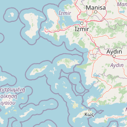
The Dilek Peninsula forms a dramatic mountainous promontory extending into the Aegean Sea, measuring approximately 20 kilometers in length from east to west and 6 kilometers in width from north to south. The peninsula's terrain is characterized by steep mountain slopes, deep valleys, and numerous canyons, with Mount Mycale (Dilek Dağı) rising to 1,237 meters as the highest peak. The geology reflects the complex tectonic history of the Aegean region, composed of Paleozoic schist formations, Mesozoic limestone and marble deposits, and Neogene clay sediments. Along the coastline, the peninsula features multiple named coves including İçmeler Cove with its sandy beaches and shallow waters, Aydınlık Cove with pebbly shores and deeper waters, Kavaklı Burun Cove, and Karasu Cove at the western tip. The Büyük Menderes Delta comprises flat wetland terrain spanning 16,613 hectares, larger than the peninsula itself, featuring lagoons, salt marshes, and mudflats where the river meets the sea. The delta's landscape creates a stark contrast to the mountainous peninsula, with the nearby mountains of the peninsula causing marked temperature differences between the northern and southern faces.

Dilek Peninsula-Büyük Menderes Delta National Park ecosystems, habitats, and plant life

The park's ecological diversity stems from the interaction between Mediterranean coastal environments and wetland systems within a relatively compact area. The temperature and climate differences between various elevations and aspects support an exceptional range of vegetation types, combining typical Aegean flora with species more commonly found in Turkey's Mediterranean, Marmara, and Black Sea regions. Of the 804 plant species documented within the park, six are entirely endemic to the area and cannot be found anywhere else in the world, while an additional 30 are indigenous to Turkey. The park has been recognized by the European Council as a Flora Biogenetic Reserve Area, acknowledging its unique role in preserving plant genetic diversity. Mediterranean maquis shrubs, particularly Phoenician juniper, dominate the lower elevations, while the Turkish pine, oleaster-leafed pear, and elm-leaved sumach represent common species throughout the peninsula. The delta's wetland environment supports distinct vegetation communities adapted to periodic flooding and brackish water conditions.

Dilek Peninsula-Büyük Menderes Delta National Park wildlife and species highlights

The park hosts impressive faunal diversity with 28 mammal species, 42 reptile species, 45 fish species, and 256 bird species documented within its boundaries. Among the mammals, wild boar are commonly observed near beaches, while golden jackals, Eurasian lynx, striped hyenas, and caracals inhabit the denser forest areas. The Turkish Wikipedia notes the peninsula represents the westernmost habitat for the endangered Anatolian leopard. The delta and coastal areas provide critical habitat for endangered bird species including pygmy cormorants, little egrets, lesser kestrels, Kentish plovers, white-tailed eagles, and particularly Dalmatian pelicans, for which the park serves as a key nesting site. Marine biodiversity includes sea turtles and critically endangered Mediterranean monk seals, with occasional fin whale sightings and dolphin populations in the surrounding waters. The park's multiple international conservation designations reflect its significance as a refuge for threatened species.

Dilek Peninsula-Büyük Menderes Delta National Park conservation status and protection priorities

Dilek Peninsula-Büyük Menderes Delta National Park is protected by an exceptional framework of international conservation agreements, reflecting its outstanding ecological value. The entire park is designated as a Ramsar Convention wetland of international importance, recognizing the delta's critical role as habitat for waterbirds and biodiversity. It is also protected under the Berne Convention on the Conservation of European Wildlife and Natural Habitats, the Rio Convention on Biological Diversity, and the Barcelona Convention for the protection of the Mediterranean Sea. The park has been identified as an Important Bird Area, Important Plant Area, and Important Mammal Area, qualifying it as an Important Nature Area in Turkey's conservation framework. Management restrictions prohibit camping, fires, and overnight stays within park boundaries, while hunting is strictly forbidden, with severe penalties for violations. The prohibition on beekeeping within the park protects the abundant flora that depends on native pollinators.

Dilek Peninsula-Büyük Menderes Delta National Park cultural meaning and human context

The Dilek Peninsula holds significant archaeological and cultural heritage within its protected boundaries. The area was inhabited during the Ionian period, with remnants of ancient settlements including the sacred meeting site of the Ionian League at Panionium near Mount Mycale, the ancient city of Thebai, and the Hellenistic port city of Karine. The Doğanbey village (ancient Domatia) and the Ayayorgi Monastery provide historical context to human presence in the region. The Cave of Zeus (Zeus Mağarası), located near the park entrance, carries mythological significance with legends suggesting Zeus bathed in its clear subterranean spring waters. The park sits directly across the narrow Mycale Strait from the Greek island of Samos, creating a landscape of international border significance where ancient Greek civilization once flourished on both sides.

Top sights and standout views in Dilek Peninsula-Büyük Menderes Delta National Park

The park offers exceptional diversity within a single visit experience, combining mountainous hiking terrain with wetland exploration and coastal beach recreation. The Büyük Menderes Delta provides one of Turkey's most important birdwatching opportunities, particularly for observing nesting Dalmatian pelicans and migratory waterfowl. The peninsula's network of forest trails leads through diverse vegetation to scenic viewpoints overlooking the Aegean Sea and the nearby Greek island of Samos. The Cave of Zeus offers a unique geological attraction with its clear spring waters and associated mythological traditions. The cove system along the peninsula's southern shore, from İçmeler through Aydınlık to the less-visited Kavaklı Burun and Karasu coves, provides progressively more challenging swimming conditions for visitors. The park's proximity to Kuşadası cruise and resort tourism makes it accessible for day visits while maintaining substantial natural protection.

Best time to visit Dilek Peninsula-Büyük Menderes Delta National Park

The park is open year-round with seasonal operating hours, from 8:00 to 19:00 during spring and summer months, and closing at 17:00 during autumn and winter. The most popular visitation period coincides with spring and summer when warm weather makes beach activities and hiking most appealing, though this also means larger crowds at popular coves. The wetland delta is particularly rewarding during migration seasons when thousands of birds pass through the area. Summer months offer the clearest waters for swimming but also bring the highest visitor numbers. Winter provides a quieter experience with fewer tourists, though some facilities have reduced hours. The Cave of Zeus becomes more popular during rougher summer beach conditions when visitors seek alternative attractions. Admission is charged at the park entrance, and the park is accessible via regular dolmuş service from Kuşadası to Güzelçamlı, with ferry options recently added.

Park location guide

Geography guide, regional context, and park location map for Dilek Peninsula-Büyük Menderes Delta National Park

Dilek Peninsula-Büyük Menderes Delta National Park park geography, regions, and map view in Turkey
Understand where Dilek Peninsula-Büyük Menderes Delta National Park sits in Turkey through a broader geographic reading of the surrounding landscape, nearby location context, and its mapped position within the national park landscape.

How Dilek Peninsula-Büyük Menderes Delta National Park fits into Turkey

Turkey, officially the Republic of Türkiye, is a transcontinental country located mainly in Anatolia (West Asia) with a smaller portion in East Thrace (Southeast Europe). It borders the Black Sea to the north, several countries to the east and south, and the Aegean Sea and European countries to the west. The country has a population of over 86 million and operates as a secular, Muslim-majority presidential republic with Ankara as capital and Istanbul as its largest city.

Wider geography shaping Dilek Peninsula-Büyük Menderes Delta National Park in Turkey

Turkey is a transcontinental country with the majority of its territory (about 97%) located in Anatolia (West Asia) and a smaller portion called East Thrace in Southeast Europe. It borders the Black Sea to the north, Georgia, Armenia, Azerbaijan, and Iran to the east, Iraq and Syria to the south, and the Mediterranean Sea to the southwest. To the west, Turkey borders the Aegean Sea, Greece, and Bulgaria. The terrain includes mountains, plateaus, and coastal plains, with the Taurus Mountains running along the southern coast.

Map view of Dilek Peninsula-Büyük Menderes Delta National Park

Use this park location map to pinpoint Dilek Peninsula-Büyük Menderes Delta National Park in Turkey, understand its exact geographic position, and read its mapped placement within the surrounding landscape more clearly.

Pigeon | © OpenStreetMap contributors

Location context for Dilek Peninsula-Büyük Menderes Delta National Park

Aydın Province
Park atlas

Explore nearby protected areas and compare diverse landscapes across Aydın Province and the broader Aegean Region.

Discover Other National Parks and Protected Areas Near Dilek Peninsula-Büyük Menderes Delta National Park
Browse a selection of national parks and protected areas located geographically close to Dilek Peninsula-Büyük Menderes Delta National Park, spanning Turkey's Aegean Region. A comparison of these areas provides deeper insights into regional conservation efforts, diverse landscapes, and connected protected ecosystems across Aydın Province.
National parkMuğla Province

Marmaris National Park: Mediterranean Forest Protected Landscape and Ancient Heritage

Discover its geography, mapped boundaries, and unique flora.

Marmaris National Park in Muğla Province offers a deep dive into a protected Mediterranean forest ecosystem and Carian history. Explore its rugged terrain, dramatic coastlines where pine forests meet the sea, and discover ancient sites like the Amos amphitheatre. This park is a key area for understanding regional geography, mapped natural landscapes, and the unique botanical diversity of Turkey's southwestern coast, supporting detailed atlas exploration.

Area
333.5 km²
Established
1996
Visitors
8.5M annual
Relief
Mixed relief
Watercolor painting of a river flowing through green hills and mountains under a soft sky.
National parkMuğla Province

Saklıkent National Park: Explore Turkey's Deepest Gorge, Limestone Formations, and Protected Terrain

A remarkable national park showcasing dramatic canyon geography and karst landscapes.

Saklıkent National Park presents an extraordinary example of a protected landscape dominated by a deep limestone canyon in Muğla Province, Turkey. This national park invites exploration of its striking geological features, including towering cliffs and flowing karstic springs that form a spectacular gorge. Users engaging with Saklıkent National Park gain insight into the mapped boundaries of protected areas and the unique natural terrain sculpted by water over millennia, offering a rich geographic context for atlas discovery.

Area
16.43 km²
Established
1996
Visitors
200K annual
Relief
Mountain
Protected areaTurkey

Ancient Troya National Park: A Mapped Protected Landscape with Deep Historical Significance

Explore the terrain and protected boundaries of this key Turkish heritage site.

Ancient Troya National Park offers a unique window into history, preserving the layers of the ancient city of Troy within its protected boundaries. Situated in Turkey, this park encompasses a significant archaeological site on a commanding hilltop, overlooking rolling Mediterranean terrain and coastal plains. Its landscape, characterized by fortified walls, gates, and the remnants of ancient structures, provides a rich context for understanding its mythological and historical importance. MoriAtlas provides detailed mapping and geographic context for this vital protected area, enhancing its atlas exploration value.

Established
1996
Relief
Lowland
Climate
Mediterranean
Access
Moderate access
Protected areaTurkey

Commander-in-Chief National Historic Park: Historic Battlefield Landscape in Turkey

Protected Area preserving pivotal geography and military history.

Commander-in-Chief National Historic Park is a designated protected area in Turkey, preserving the historic terrain of the decisive Battle of Dumlupınar. This site offers a unique glimpse into the geography and landscape that were instrumental in a key moment of the Turkish War of Independence. Explore the mapped context of this significant battlefield, understanding its role within the broader Anatolian geography and its importance as a preserved historic site.

Area
409.48 km²
Established
1981
Relief
Mixed relief
Climate
Temperate
Watercolor illustration of a coastal landscape with hills, trees, and a body of water
Marine protected area

National Marine Park of Alonnisos Northern Sporades: Protected Marine Landscape and Aegean Geography

Explore Greece's largest marine protected area and its vital ecosystems.

Investigate the National Marine Park of Alonnisos Northern Sporades, an extensive marine protected area situated in the northern Aegean Sea. This protected landscape is internationally significant for its role in conserving the Mediterranean monk seal and for its healthy Posidonia oceanica seagrass meadows. Understanding this park's geographic scope and its protected marine terrain offers crucial insights into Mediterranean island ecosystems and conservation efforts within the region.

Area
2,260 km²
Established
1992
IUCN
II
Relief
Mixed relief
Watercolor painting showing a lake, mountains, trees, and grassy shoreline
National parkIsparta Province

Lake Kovada National Park: Mapped Protected Landscape in Isparta Province

Discover the geography and lake ecosystem of this Turkish national park.

Lake Kovada National Park offers a detailed look at a protected natural area within Turkey's Isparta Province. This page provides insights into the park's protected landscape, focusing on the central freshwater lake and its surrounding montane terrain. Explore its geographic context, mapped boundaries, and status as a significant protected area within the Taurus Mountain region, ideal for atlas-based discovery of Anatolian natural environments.

Area
65.51 km²
Established
1970
Scope
Terrestrial
Water
Major water bodies
National parkTurkey

Lake Gala National Park: A Key Protected Wetland Landscape in Turkey's Maritsa Delta

Discover its bird habitats and mapped geographic context.

Lake Gala National Park is a nationally significant protected area, designated in 2005 to conserve the unique wetland ecosystem of the Maritsa Delta. Encompassing the shallow lakes Pamuklu and Küçük Gala, this park spans approximately 6,090 hectares of diverse wetland and forest habitats. It is internationally recognized as a Ramsar site and serves as a critical sanctuary for over 160 bird species, making it a premier birdwatching destination in Turkey and an important locus for understanding protected landscapes within a regional geographic framework.

Area
60.9 km²
Established
2005
Relief
Lowland
Climate
Temperate
Watercolor illustration of green hills, pine trees, and distant mountains under a light sky
National parkIsparta Province

Kızıldağ National Park: Protected Taurus Mountain Landscape and Atlas Context

Mapped boundaries, alpine terrain, and unique cedar forests.

Kızıldağ National Park offers a detailed look into Turkey's protected natural heritage, specifically highlighting the dramatic mountainous terrain of the Taurus Ranges. This page provides atlas-level geographic information about its mapped boundaries, the significant Dedegöl Mountain, and the rare blue-leaf cedar forests unique to this region. Understand its role as a vital conservation area within Isparta Province and the broader Mediterranean mountain ecosystem.

Area
551.06 km²
Established
1969
Relief
Mountain
Scope
Terrestrial

Common questions about visiting, size, designation, and location context for Dilek Peninsula-Büyük Menderes Delta National Park

Dilek Peninsula-Büyük Menderes Delta National Park FAQs for park facts, access, geography, and protected area context
Find quick answers about Dilek Peninsula-Büyük Menderes Delta National Park, including protected-area facts, park geography, trail and visitor context, and how the park fits into its surrounding country and regional landscape.
MoriAtlas Explorer

Continue Your Protected Areas Search Across the Global Atlas

Deepen your exploration by continuing the structured search for national parks and protected areas worldwide. Utilize the comprehensive filtering capabilities to compare different conservation landscapes and refine your understanding of global park geography. Discover more about the distribution and characteristics of protected natural areas.

Global natural geography