Mori Atlas logo
National parkDjurdjura National Park

Discover the mapped geography and regional park context of Djurdjura National Park in Kabylie.

Djurdjura National Park: Algeria's National Park and Protected Landscape Identity

Djurdjura National Park stands as a significant protected natural area within Algeria, specifically situated in the Kabylie region. As a national park, it represents a key entity for understanding the distribution of protected lands and their geographical significance across North Africa. This page provides a foundational atlas-style exploration of Djurdjura National Park, detailing its mapped landscape context and its role as a distinct protected area.

Alpine MountainsProtected ForestsEndangered SpeciesTell AtlasMediterranean EcosystemsKabylie Region

Djurdjura National Park

National park

Park overview

Structured park overview, official facts, and landscape profile for Djurdjura National Park

Djurdjura National Park park facts, protected area profile, and essential visitor context

Review the core facts for Djurdjura National Park, including designation, size, terrain, visitor scale, habitats, and operating context in one park-focused overview.

About Djurdjura National Park

Djurdjura National Park encompasses the mountainous heart of the Djurdjura Range in the Tell Atlas system of northern Algeria. The park's landscape is defined by its dramatic topography, with rugged peaks rising sharply from the surrounding terrain, deep gorges cutting through the mountain mass, and cascading streams feeding forested valleys. The name Djurdjura originates from the Kabyle language, derived from the word "Jjerjer" meaning either "great cold" or "elevation," and from the compound phrase "Jer n Jer" translating to "the mountain of the mountains." This etymology reflects both the physical prominence of the range and its climatic character at higher elevations. During the Roman period, the mountains were known as Mons Ferratus, or "Iron Mountain," a designation that referenced both the mineral-rich soils and the fierce resistance of the Kabyle people against Roman authority. The park serves as a critical protected area within Algeria's network of national parks, preserving not only geological and scenic values but also functioning as a sanctuary for species of conservation concern in the Mediterranean region.

Quick facts and research context for Djurdjura National Park

Djurdjura National Park lies in the Kabylie region of northern Algeria within the Djurdjura Range of the Tell Atlas mountains. The park was established on July 23, 1983, covering 185 square kilometers of mountainous terrain. It is classified as an IUCN Category II protected area, representing one of Algeria's seven national parks. The park is located near the cities of Tizi Ouzou to the north and Bouïra to the south, at coordinates approximately 36.47°N 4.13°E. The area features a complex geological structure with broken tectonic formations, alongside forests, caves, and gorges that create diverse microhabitats.

Protection and recognition

Exploring documented terrestrial protection boundaries and UNESCO Biosphere Reserve status

Djurdjura National Park Protection Status and Global Conservation Designations

Documented terrestrial data outlines the legal protection framework and official management boundaries established for Djurdjura National Park. Integrating international designations such as its UNESCO Biosphere Reserve status helps researchers trace global ecological significance and regional conservation alignment.

International recognition

Protection details

Protection scope
Terrestrial
Designated year
1997
Transboundary protection
No
Core area
140.59 km²
Buffer area
12.21 km²
Park context

Deeper park guide and search-rich context for Djurdjura National Park

Djurdjura National Park history, landscape, wildlife, and travel context

Explore Djurdjura National Park through its history, landscape character, ecosystems, wildlife, conservation priorities, cultural context, and seasonal travel timing in a structured park guide built for atlas discovery and search intent.

Why Djurdjura National Park stands out

Djurdjura National Park is best known for its population of endangered Barbary macaques, one of the few primate species remaining in North Africa and the only macaque species found outside Asia. The park also protects the dramatic alpine landscapes of the Djurdjura Range, with its steep peaks, forest-covered slopes, and deep gorges representing some of the most rugged terrain in northern Algeria. The combination of significant biodiversity, particularly the endangered primate population, and the cultural significance of the surrounding Kabylie region makes this park a unique conservation priority in the Mediterranean basin.

Djurdjura National Park history and protected-area timeline

Djurdjura National Park was officially established on July 23, 1983, becoming one of Algeria's newer protected areas relative to parks established in the earlier decades of independence. The creation of the park reflected Algeria's broader commitment to conserving its mountainous ecosystems and biodiversity during the 1980s, a period when several national parks were designated across the country's diverse ecological zones. The park was assigned IUCN Category II status, recognizing its primary purpose of protecting natural ecosystems while allowing for sustainable visitor use. Prior to formal protection, the Djurdjura Range had long served as a natural refuge for wildlife, including populations of Barbary macaques that persisted in the forests despite historical habitat loss elsewhere in North Africa. The establishment of the park also acknowledged the cultural significance of the Kabylie region, where local communities have maintained connections to these mountains for generations.

Djurdjura National Park landscape and geographic character

The landscape of Djurdjura National Park is characterized by mountainous terrain of exceptional ruggedness and scenic diversity. The Djurdjura Range forms part of the Tell Atlas system, a series of east-west trending mountain chains that parallel the Mediterranean coast of northern Algeria. The park encompasses dramatic peaks, steep-sided valleys, and eroded gorges that have been carved by water over geological time. The terrain features broken tectonic formations, indicating a complex geological history that has produced varied landforms including karst cave systems and limestone grottoes. Dense forests clothing the slopes contribute to the visual character of the park, particularly in the more sheltered valleys and lower elevations. The combination of vertical relief, forest cover, and water-carved ravines creates a landscape that contrasts sharply with the semi-arid terrain typical of much of inland Algeria, making the Djurdjura mountains a distinctive visual and ecological element in the northern landscape.

Djurdjura National Park ecosystems, habitats, and plant life

The natural environment of Djurdjura National Park supports Mediterranean and sub-Mediterranean ecosystems adapted to the mountain setting. The forests that cover much of the park's area represent some of the most extensive woodland in northern Algeria, providing habitat for species adapted to cooler, more humid conditions than found at lower elevations. The complexity of the terrain creates numerous microhabitats, from rocky outcrops and cliff faces to shaded gorges and forest clearings, supporting botanical diversity across elevation zones. The park's position within the Tell Atlas places it at a biogeographic crossroads, where Mediterranean species meet more montane elements. The presence of permanent water sources in the form of streams and springs, emerging from the mountainous catchment, sustains ecosystems even during the dry summer months and provides critical resources for wildlife throughout the year.

Djurdjura National Park wildlife and species highlights

Djurdjura National Park is home to several notable species, with the endangered Barbary macaque standing as the most internationally significant wildlife presence. These primates represent one of the few remaining populations of Macaca sylvanus in North Africa, a species whose historic range once extended across much of the region but has contracted dramatically due to habitat loss and human disturbance. The macaques in Djurdjura inhabit the forested slopes of the mountains, finding refuge in the dense woodland and rocky areas that provide both food resources and shelter. Beyond the primates, the park supports diverse fauna including numerous bird species adapted to forest and cliff habitats, small mammals, and reptile species occupying the varied microenvironments created by the park's topography. The grottoes and caves within the park provide shelter for cave-dwelling species, while the forest canopy supports avian communities including birds of prey.

Djurdjura National Park conservation status and protection priorities

Djurdjura National Park represents an important conservation asset for Algeria and for the broader Mediterranean region. The park's protected status provides formal recognition of the need to preserve both its unique ecosystems and its endangered species populations. The Barbary macaque population is of particular conservation concern, as the species is listed as endangered, and protected areas like Djurdjura serve as crucial refuges where viable populations can persist. The forest ecosystems within the park also hold conservation value, representing relatively intact examples of Mediterranean mountain woodland that have retained biological diversity despite surrounding landscape changes. The designation of IUCN Category II reflects the park's role in protecting natural processes and biodiversity while allowing for compatible visitor use, balancing conservation objectives with public access to the mountain environment.

Djurdjura National Park cultural meaning and human context

The Djurdjura mountains hold deep cultural significance for the Kabyle people, an Amazigh (Berber) population indigenous to the region. The name Djurdjura itself derives from Kabyle language roots, and the mountains have historically served as both a physical and symbolic homeland for local communities. The term "Mmis n'Djerdjer," meaning "children of the Djurdjura," represents a cultural identity marker linking inhabitants to these mountains. Traditional land use practices in the surrounding areas reflect centuries of human interaction with the mountain environment, including pastoral activities and forest resource use. The Roman-era name Mons Ferratus testifies to the region's historical importance and its reputation for resistance during the period of Roman colonization. The cultural heritage of Kabylie adds dimension to the park's significance beyond its ecological values, intertwining natural and cultural preservation goals.

Top sights and standout views in Djurdjura National Park

The defining highlights of Djurdjura National Park include the dramatic mountainous scenery of the Djurdjura Range, with its rugged peaks and deep gorges providing exceptional visual appeal. The endangered Barbary macaque populations represent a unique wildlife attraction, offering visitors the chance to observe these primates in their natural mountain forest habitat. The park's extensive forests create opportunities for exploring diverse Mediterranean ecosystems, while the limestone grottoes and caves add geological interest to the visitor experience. The cultural heritage of the surrounding Kabylie region provides additional context for understanding the mountains' significance beyond their ecological value. Combined, these elements make Djurdjura one of Algeria's most distinctive protected areas, offering both natural and cultural discovery within a relatively compact mountain landscape.

Best time to visit Djurdjura National Park

The best time to visit Djurdjura National Park depends on the type of experience sought, though the spring and early summer months generally offer the most favorable conditions for exploration. During spring, the mountain landscapes display vibrant vegetation and wildflower displays across the forested slopes, while temperatures remain comfortable for hiking and outdoor activities. Summer brings warmer conditions but also the greenest forest cover, though the park can experience higher visitor numbers during this peak season. Autumn offers another excellent window, with pleasant temperatures and the opportunity to observe seasonal changes in the forest environment. Winter conditions in the mountains can be harsh, with snow possible at higher elevations, but the park retains a stark beauty during the colder months for those prepared for winter conditions. The seasonal patterns reflect the Mediterranean climate of the region, with most precipitation falling during the winter months and drier conditions prevailing through summer.
Monthly climate preview

Long-term weather normals and temperature cycles measured at the Kabylie representative elevation

Average Temperatures and Weather by Month in Djurdjura National Park

Long-term data from a representative coordinate at 641 meters show a clear annual pattern with hot, dry mid-year periods exceeding 41 °C and cooler, wetter months falling below freezing. Exploring the dedicated climate dataset offers complete weather by month averages, daily precipitation trends, and historical temperature ranges.
Annual mean16 °C
7 °C27 °C
Jan
Feb
Mar10°
Apr13°
May17°
Jun22°
Jul27°
Aug27°
Sep22°
Oct17°
Nov11°
Dec
Warmest month
August

26.8 °C

Coolest month
January

6.6 °C

Wettest month
January

3.7 mm/day

Driest month
July

0.2 mm/day

Park location guide

Geography guide, regional context, and park location map for Djurdjura National Park

Djurdjura National Park park geography, regions, and map view in Algeria

Understand where Djurdjura National Park sits in Algeria through a broader geographic reading of the surrounding landscape, nearby location context, and its mapped position within the national park landscape.

How Djurdjura National Park fits into Algeria

Algeria is a North African country spanning over 2.38 million km², making it the largest country in Africa. It borders the Mediterranean Sea to the north and shares land borders with seven countries. The population exceeds 47 million, with most concentrated in the northern coastal region.

Wider geography shaping Djurdjura National Park in Algeria

Algeria occupies the central portion of the Maghreb region in North Africa. It is bordered by Tunisia and Libya to the northeast, Niger to the southeast, Mali, Mauritania, and Western Sahara to the southwest, and Morocco to the west. The Mediterranean Sea forms its northern border. The terrain consists of the Tell Atlas mountain range and coastal plains in the north, transitioning to the Sahara desert in the south.

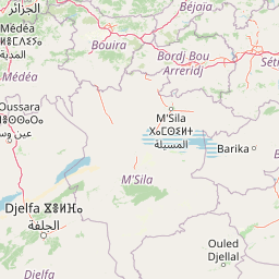
Map view of Djurdjura National Park

Use this park location map to pinpoint Djurdjura National Park in Algeria, understand its exact geographic position, and read its mapped placement within the surrounding landscape more clearly.

Pigeon | © OpenStreetMap contributors

Location context for Djurdjura National Park

Kabylie
Park atlas

Trace the broader geographic context of protected landscapes across the Tell Atlas and North Africa.

Discover More National Parks and Protected Areas Surrounding Djurdjura National Park

Explore additional national parks and protected areas closely related to Djurdjura National Park, mapping their geographic spread across the Tell Atlas and adjacent North African mountain systems. Compare distinct conservation landscapes and trace how diverse ecosystems are protected within this broader regional context, providing deeper atlas-style discovery.
National parkBéjaïa Province
About 83 km away#1 closest

Northeast

Gouraya National Park: Algeria's Protected Landscape in Béjaïa Province

Discover its mapped boundaries and regional geography.

Gouraya National Park is a designated national park in Algeria, located within the administrative region of Béjaïa Province. This MoriAtlas entry focuses on its protected-area status and geographic identity, providing key details for atlas-driven exploration. Users can understand the park's mapped landscape, its regional context, and its significance as a protected natural area for geographic study and discovery.

Area
20.8 km²
Established
1984
IUCN
II
Visitors
60K annual
Watercolor painting showing mountain ranges with snow-capped peaks, green forests, and rolling hills in a scenic landscape
National parkAlgeria
About 114 km away#2 closest

West

Chréa National Park: Algeria's Unique Mountain Landscape and Ancient Cedar Atlas

Explore protected terrain, mapped cedar forests, and unique habitats in the Tell Atlas.

Chréa National Park is a significant protected natural area in Algeria, renowned for its ancient Atlas cedar forests and its position within the mountainous Blidean Atlas range. This national park preserves a unique landscape characterized by dramatic ridgelines, diverse elevations, and critical habitats for species like the Barbary macaque. Its protected status ensures the conservation of these vital ecosystems, offering users a rich resource for understanding Algeria's mountain geography and the distribution of its rare cedar forest ecosystems.

Area
260 km²
Established
1985
IUCN
II
Relief
Mountain
National parkJijel Province
About 123 km away#3 closest

East

Taza National Park: Protected Mediterranean Coast and Tell Atlas Forest Landscape

Explore its unique mapped geography and conservation significance.

Taza National Park, situated in Algeria's Jijel Province, represents a crucial protected landscape where the Tell Atlas mountains meet the Mediterranean Sea. This 3,807-hectare national park is celebrated for its dramatic coastal cliffs, extensive cork oak and gall oak forests, the largest in Algeria, and its designation as a UNESCO biosphere reserve. The park's geography facilitates unique habitat zones, making it a key area for atlas-based discovery of North African biodiversity, including the Barbary macaque and Algerian nuthatch, within a landscape of exceptional natural beauty and conservation priority.

Area
38.07 km²
Established
1923
IUCN
II
Relief
Mountain
National parkBatna Province
About 197 km away#4 closest

Southeast

Belezma National Park National Park: Mapped Protected Landscape and Geographic Context in Batna Province

Explore its protected area boundaries and regional natural terrain.

Gain a clear understanding of Belezma National Park's protected landscape and geographic position. This entry details its mapped boundaries within Batna Province, providing essential context for atlas-based exploration of Algeria's natural terrain and protected areas. Discover the specific geographic identity that makes Belezma National Park a key feature within its regional landscape.

Area
262.5 km²
Established
1984
IUCN
II
Visitors
100K annual
National parkAlgeria
About 227 km away#5 closest

West

Théniet El Had National Park: Atlas Cedar Forests in Algeria's Tell Atlas Mountains

Discover protected montane landscape and regional geography.

Théniet El Had National Park represents a significant protected landscape in Algeria, characterized by its towering Atlas cedar forests and dramatic mountainous terrain within the Tell Atlas range. Spanning elevations from 1,200 to over 2,200 meters, this national park offers a distinct example of Mediterranean mountain ecosystems. Its unique forest cover and rugged topography provide crucial habitat and watershed functions, making it a key location for understanding protected area geography and landscape context in North Africa.

IUCN
II
Relief
Mountain
Climate
Mediterranean
Scope
Terrestrial
Watercolor painting showing green hills, mountain ranges, and soft pastel skies
Protected areaSpain
About 316 km away#6 closest

North

Cabrera National Park: A Mapped Protected Area in the Balearic Islands

Explore Mediterranean island geography and protected marine ecosystems.

Cabrera National Park, a protected maritime-terrestrial area in Spain's Balearic Islands, offers a unique focus for geographic discovery. This entry details the archipelago's distinct island geography, its mapped coastal and marine ecosystems, and its role within the Mediterranean. Users can explore the park's protected boundaries and understand its place in the regional atlas for a comprehensive view of Spain's island conservation landscapes.

IUCN
II
Scope
Mixed
Water
Water-dominated
Nature reserveIslas Baleares
About 361 km away#7 closest

Northwest

Parque natural de las Salinas: Protected Coastal Geography in the Balearic Islands

Nature reserve featuring historic salt pans and marine Posidonia habitats.

Spanning the southern Ibiza and northern Formentera coastlines, Parque natural de las Salinas is defined by its characteristic salt-pan geography and protected coastal wetlands. The reserve offers deep insight into the Mediterranean coastal environment, from its shallow marine channels and Es Freus islets to the preserved heritage of traditional salt production landscapes.

Area
158.38 km²
Established
1999
Scope
Mixed
Water
Water-dominated
National parkEl Tarf Province
About 366 km away#8 closest

East

El Kala National Park: Protected Wetlands and Barbary Stag Habitat

Explore its mapped geography and vital ecosystem context.

El Kala National Park represents a crucial protected landscape within El Tarf Province, Algeria, recognized internationally for its extensive Mediterranean wetlands and rich biodiversity. This national park is a vital ecological zone, comprising six major lakes and a significant stretch of coastline, offering a unique mosaic of aquatic and terrestrial environments. Its role as a sanctuary for the Barbary stag and migratory birds highlights its importance in regional conservation efforts. Exploring El Kala National Park provides insight into the mapped terrain, protected boundaries, and distinct geographic features that define this significant North African natural area.

Area
764 km²
Established
1993
IUCN
II
Visitors
30K annual

Common questions about visiting, size, designation, and location context for Djurdjura National Park

Djurdjura National Park FAQs for park facts, access, geography, and protected area context

Find quick answers about Djurdjura National Park, including protected-area facts, park geography, trail and visitor context, and how the park fits into its surrounding country and regional landscape.
MoriAtlas Explorer

Continue Your Protected Areas Search Across the Global Atlas

Deepen your exploration by continuing the structured search for national parks and protected areas worldwide. Utilize the comprehensive filtering capabilities to compare different conservation landscapes and refine your understanding of global park geography. Discover more about the distribution and characteristics of protected natural areas.

Global natural geography