
Viewpoints
Park geography
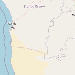
A detailed atlas of the park boundary, terrain features, and regional coastal desert geography
Comprehensive Geographic Profile and Mapped Boundaries of Dorob National Park in Namibia
This geographic profile provides structured data for Dorob National Park, a significant protected area spanning the coastal landscape of the Erongo region in Namibia. Users can examine its mapped boundaries, regional extent, and defined relief types. The resource also highlights internal physical features including craters, dunes, and coastal landmarks within this arid, desert-dominated environment.
Related tags
Coastal DesertBird ConservationImportant Bird AreaNamib DesertMarine-Coastal Interface
Namibia's dramatic coastal desert park protecting a hyper-arid shoreline teeming with birdlife
Dorob National Park
Dorob National Park is a vast coastal protected area in Namibia's Erongo region, stretching 1,600 kilometers along the central Namibian coast from the Kuiseb Delta south of Walvis Bay north to the Ugab River. Established on December 1, 2010, the park covers 107,540 square kilometers in combination with adjacent Namib-Naukluft Park, making it part of one of Africa's largest contiguous protected coastal zones. The park's name derives from the local word for "dry land," reflecting the hyper-arid desert environment that defines this remarkable coastline where the Atlantic Ocean meets the Namib Desert. The area is recognized as Namibia's richest coastal region for birdlife, supporting approximately 75 species and nearly 1.6 million individual birds, earning it designation as an Important Bird Area by BirdLife International.
- Location
- Namibia
- Park type
- National park
- Established
- 2010
- Area
- 107,540 km²
Location overview
Regional placement and coastal designation within the Erongo territory
Geographic Location and Regional Profile of Dorob National Park
Dorob National Park is positioned within the Erongo region of Namibia. National records classify the designated territory under both coastal and marine designations for conservation tracking.
- Countries
- Namibia
- Regions
- Erongo
- Primary location
- Namibia
- Geographic setting
- Coastal · Marine
Boundary and coordinates
Mapping the spatial extent and coordinates across 107,540 square kilometers
Geographic Boundary Map and Spatial Limits of Dorob National Park
The mapped spatial outline traces the geographic reach and regional footprint of Dorob National Park. Calculated database metrics establish the estimated total area, center coordinates, and latitudinal spans of the reserve.
- Boundary area
- 8,206.3 km²
- Boundary perimeter
- 809 km
- Northernmost point
- 21.0001° S
- Southernmost point
- 23.2394° S
- Easternmost point
- 14.965° E
- Westernmost point
- 13.6327° E
- Geographic centre
- 21.9746° S, 14.3176° E
- North–south span
- 248 km
- East–west span
- 137.5 km
Terrain and natural features
Mapped lowland terrain types and recorded natural landmarks
Dorob National Park Terrain Geography and Named Natural Features
Recorded lowland relief classifications define the landscape within Dorob National Park alongside mapped rivers and viewpoints. Individual feature cards detail types and spatial relationships for each landmark.
Selected named natural features
Natural springs
Haigamkab
Peninsulas
Walvis Bay Peninsula
Viewpoints
Swartklip
Rivers
Messum
Streams
Ururas
Environmental setting
Arid lowland terrain, coastal dunes, and marine wetland zones
Dorob National Park Environmental Classifications and Physical Geography
Stored classifications combine coastal, desert, and riverine habitats into broad interpretive categories for physical terrain analysis. Recorded environmental profiles connect directly to matching regional atlas destinations.
- Relief
- Lowland
- Climate
- Arid
- Water
- Major water bodies
- Forest cover
- No forest cover
- Seasonality
- Seasonal
Landscape features
Coast · Dunes · Desert · Rivers · Wetland · Lakes
Habitat types
Coastal habitat · Marine habitat · Dune habitat · Desert habitat · Wetland · Riverine habitat · Lacustrine habitat
Park atlas
Compare Namibia's coastal protected areas, tracing the Atlantic interface with the Namib Desert
Discover Other National Parks and Protected Areas Near Dorob National Park
After exploring Dorob National Park, delve into additional protected areas within Namibia's unique coastal desert environment and the broader Namib Desert region. Trace the geographic spread of marine-influenced conservation landscapes and adjacent desert parks, comparing diverse ecosystems across a significant African protected zone.
National parkNamibia
Park boundaries overlap#1 closest
Southeast

Namib-Naukluft National Park: Namibia's Iconic Desert Landscape and Protected Terrain
Explore its ancient dunes, Naukluft mountains, and coastal geography.
Namib-Naukluft National Park is a colossal protected area in Namibia, holding the distinction of being Africa's largest national park. This park is renowned for its iconic sand dunes, particularly at Sossusvlei, which are among the highest in the world and display dramatic colors due to iron oxidation. The landscape also features the rugged Naukluft Mountains and vital coastal fog zones, creating a diverse arid environment. Delve into the mapped geography and unique terrain of this ancient desert setting, understanding its protected landscape significance within Namibia's atlas.
- Area
- 49,768 km²
- Established
- 1907
- IUCN
- II
- Relief
- Mixed relief
National parkNamibia
Park boundaries overlap#2 closest
Northwest
Skeleton Coast National Park: Namibia's Remote Desert-Coast National Park Exploration
Mapped landscape, shipwrecks, and profound geographic isolation.
Delve into the Skeleton Coast National Park, a monumental protected area in Namibia defined by its stark desert and ocean interface. This page provides detailed geographic context for the park's vast expanse, highlighting its characteristic shipwrecks and the dramatic landscape where towering sand dunes confront the cold Atlantic. Understand the unique protected-area identity of this legendary coastal wilderness through its mapped features and remote setting.
- Area
- 16,845 km²
- Established
- 1971
- IUCN
- II
- Relief
- Lowland
National parkKunene Region
183 km away#3 closest
North
Etosha National Park National Park: Mapped Protected Landscape and Regional Geography
Discover its protected boundaries and geographic context.
Gain a structured understanding of Etosha National Park, a prominent national park within Namibia's Kunene Region. This entry focuses on the park's protected landscape identity, detailing its mapped boundaries and geographic significance. Explore Etosha National Park through the lens of atlas-driven discovery, appreciating its role as a key protected area and its contribution to the regional geography of the surrounding landscape.
- Area
- 22,270 km²
- Established
- 1907
- IUCN
- II
- Visitors
- 200K annual
Protected areaNamibia
About 192 km away#4 closest
East
Gross Barmen Protected Area: Landscape Geography and Thermal Spring Mapping in Namibia
Central Namibia thermal spring and historic natural monument
Gross Barmen is a state-managed recreation area in central Namibia, centered on a natural sulfurous spring that emerges within a flat thornveld landscape. This protected area acts as both a cultural heritage site and a geological feature, providing a clear window into the regional terrain of the Otjozondjupa area through its thermal waters and historical mission foundations.
- Area
- 1 km²
- Established
- 1968
- Relief
- Lowland
- Climate
- Arid
Protected landscapeOtjozondjupa
About 217 km away#5 closest
East
Von-Bach-Erholungsgebiet: A Protected Landscape of Dam Waters and Bushveld Terrain
Geographic overview of the Otjozondjupa recreation reserve.
The Von-Bach-Erholungsgebiet landscape defines a unique intersection between the northern Eros Mountain foothills and the Von-Bach Dam reservoir. Characterized by khaki bushveld, scattered acacia, and rolling ridges, this protected area serves as a primary hub for water-based recreation and bushland exploration in central Namibia.
- Area
- 43 km²
- Established
- 1972
- IUCN
- V
- Relief
- Upland
Nature reserveWindhoek
About 219 km away#6 closest
East
Südwest-Naturreservat: A Protected Botanical Nature Reserve in Central Windhoek
Conservation landscapes and native flora in the Khomas Highland
Located in central Windhoek, Südwest-Naturreservat functions as a key protected area and botanical site. It showcases a diverse collection of Namibian plants across both landscaped and natural terrain, offering a focused look at arid and semi-arid flora within an accessible urban environment that highlights the region's unique biodiversity.
- Area
- 0.12 km²
- Established
- 1970
- IUCN
- V
- Relief
- Upland
Wildlife reserveOtjozondjupa
About 255 km away#7 closest
Northeast
Okonjati Game Reserve: Mapped Protected Landscapes and Wildlife Geography in Namibia
Ecological terrain and historical mountain setting in Otjozondjupa.
Situated in the heart of Namibia, Okonjati Game Reserve represents a significant private conservation effort centered on the Etjo massif. This 360 square kilometer protected landscape features a blend of rocky uplands and savanna plains, providing a unique habitat for rhinoceroses, elephants, and hippopotamuses while preserving fossilized dinosaur tracks and modern historical landmarks.
- Area
- 360 km²
- Established
- 1975
- Relief
- Upland
- Climate
- Arid
National parkNamibia
304 km away#8 closest
Northeast
Waterberg Plateau Park: A Detailed Atlas of a Protected Table Mountain in Namibia
Geographic overview of the Kalahari plateau ecosystem and protected wilderness
Waterberg Plateau Park offers a deep look into one of Namibia's most recognizable natural landmarks, featuring a classic table mountain formation that rises dramatically from the savannah. This protected area provides a rich study of geological heritage, including ancient strata and isolated plateau ecosystems that support a wide range of bird species and rare fauna. The park serves as a foundational site for conservation, marking a contrast between the elevated plateau and the expansive plains below.
- Area
- 405 km²
- Established
- 1972
- IUCN
- II
- Relief
- Highland
MoriAtlas Explorer
Continue Exploring Dorob National Park's Protected Coastal Geography and Mapped Landscapes
Delve deeper into the geographic specifics of Dorob National Park, understanding its unique coastal desert terrain, mapped boundaries, and the ecological significance of its protected landscapes. This area offers invaluable insights into the intersection of hyper-arid environments and marine influence, vital for atlas-based natural discovery and conservation understanding.
Browse next
Global natural geography
Explore related park routes
Explore MoriAtlas Global ParksBrowse All MoriAtlas ParksGlobal Park Map DiscoveryMoriAtlas: Browse All CountriesBrowse All MoriAtlas ContinentsNational Park Environment AtlasGrand Canyon National Park AtlasYellowstone National Park AtlasYosemite National Park Atlas and GeographySerengeti National Park AtlasGalápagos National Park Protected LandscapeBanff National Park Geography and AtlasKruger National Park Atlas EntryUluṟu-Kata Tjuṯa National Park AtlasExplore Uluru-Kata Tjuta National Park GeographyPlitvice Lakes National Park AtlasFiordland National Park Protected LandscapeGreat Smoky Mountains National Park AtlasAfghanistan National Parks and Protected AreasAlbania National Parks and Protected AreasAlgeria National Parks and Protected AreasAmerican Samoa National Parks and Protected AreasAndorra National Parks and Protected AreasAngola National Parks and Protected AreasAntarctica National Parks and Protected AreasAntigua and Barbuda Park List