Mori Atlas logo
Nature reserveErebuni State Reserve

Explore the protected botanical boundaries and transitional mountain steppe landscapes of this unique Armenian reserve

Erebuni State Reserve: A Geographically Significant Nature Reserve in the Armenian Highlands

Erebuni State Reserve stands as a vital protected area in Armenia, occupying a distinctive transition zone between semi-desert and mountain-steppe ecosystems southeast of Yerevan. Spanning elevations between 1300 and 1450 meters, this nature reserve serves as a globally significant refuge for wild wheat species and rare endemic flora. Its geography offers a scientific enclave where hardy vegetation adapts to dry, continental conditions on the lower foothills of the Geghama range.

steppesemi-desertmountain-steppebotanical reservewild wheatplant genetic resources

Erebuni State Reserve

Nature reserve

Park overview

Structured park overview, official facts, and landscape profile for Erebuni State Reserve

Erebuni State Reserve park facts, protected area profile, and essential visitor context

Review the core facts for Erebuni State Reserve, including designation, size, terrain, visitor scale, habitats, and operating context in one park-focused overview.

About Erebuni State Reserve

Erebuni State Reserve is a compact but nationally and scientifically significant protected area in central Armenia, administered as a strict nature reserve under the Ministry of Nature Protection. It lies on the southeastern outskirts of Yerevan, within the Erebuni District, occupying a strip of semi-desert and mountain-steppe terrain that rises from approximately 1300 to 1450 meters above sea level. Although the reserve covers only around 120 hectares, it is recognized as one of the country's most important botanical conservation sites.

The reserve was established in 1981 with the explicit purpose of safeguarding wild relatives of cultivated grasses, particularly wild wheats. This focus gives Erebuni a particular scientific value: it hosts populations of wild Ararat wheat, wild Urartu wheat, and wild einkorn, three species that together represent the bulk of the world's known wild wheat diversity. The site's wild cereal gene pool, with around 110 recorded intraspecific forms, is considered globally unique and a critical resource for understanding the origins of cultivated grain.

Despite its small size and urban-adjacent setting, Erebuni also supports a rich mosaic of other plant communities, including semi-desert shrubs, feather-grass steppes, and mountain chervil formations. Rare and endemic species such as the elegant iris variety Iris iberica subsp. elegantissima grow alongside uncommon horned junipers and other species of conservation concern, several of which appear in the Red Book of Armenia.

The reserve's fauna, while less prominent than its flora, is also varied for such a small area. Amphibians, reptiles, birds, and mammals all make use of the transitional habitats, and the reserve contributes to the regional network of protected sites that support Armenia's broader biodiversity. Its proximity to Yerevan makes Erebuni distinctive among strict reserves, providing a protected natural enclave essentially on the doorstep of the capital.

Quick facts and research context for Erebuni State Reserve

Erebuni State Reserve is a strict nature reserve (IUCN Category Ia) situated in the Ararat Province of Armenia, about 8 kilometers southeast of central Yerevan, within the administrative boundaries of the Erebuni District. The reserve lies in a transitional landscape between semi-desert and mountain-steppe vegetation, at elevations between approximately 1300 and 1450 meters.

The reserve was created in 1981 specifically to conserve wild relatives of cereal grasses, and most of its protected species are listed in the Red Book of Armenia. It was expanded in 2015 from 89 to 120 hectares through the addition of land in Voghjaberd. It remains a small but ecologically focused protected area under national management, with significance that is disproportionate to its compact footprint.

Protection and recognition

Examine documented conservation parameters and official recognition data for Erebuni State Reserve

Erebuni State Reserve Protection Status and Designated Terrestrial Scope

Erebuni State Reserve maintains a documented terrestrial protection scope within the regional conservation network. Structured records outline the official designation framework and international recognition data associated with the protected landscape.

Protection details

Protection scope
Terrestrial
Transboundary protection
No
Park context

Deeper park guide and search-rich context for Erebuni State Reserve

Erebuni State Reserve history, landscape, wildlife, and travel context

Explore Erebuni State Reserve through its history, landscape character, ecosystems, wildlife, conservation priorities, cultural context, and seasonal travel timing in a structured park guide built for atlas discovery and search intent.

Why Erebuni State Reserve stands out

Erebuni is best known as one of the most important sites in the world for the conservation of wild wheat. Three of the four known wild wheat species, including Ararat wheat (Triticum araraticum), Urartu wheat, and einkorn, grow within its boundaries, and the reserve holds a globally unique gene pool for these species with around 110 intraspecific variants documented. Equally distinctive is its setting in a narrow transition zone between semi-desert and mountain-steppe vegetation, where rare and endemic plants, including iris and uncommon semi-desert species, coexist with the grassland wild cereals that give the reserve its global botanical importance.
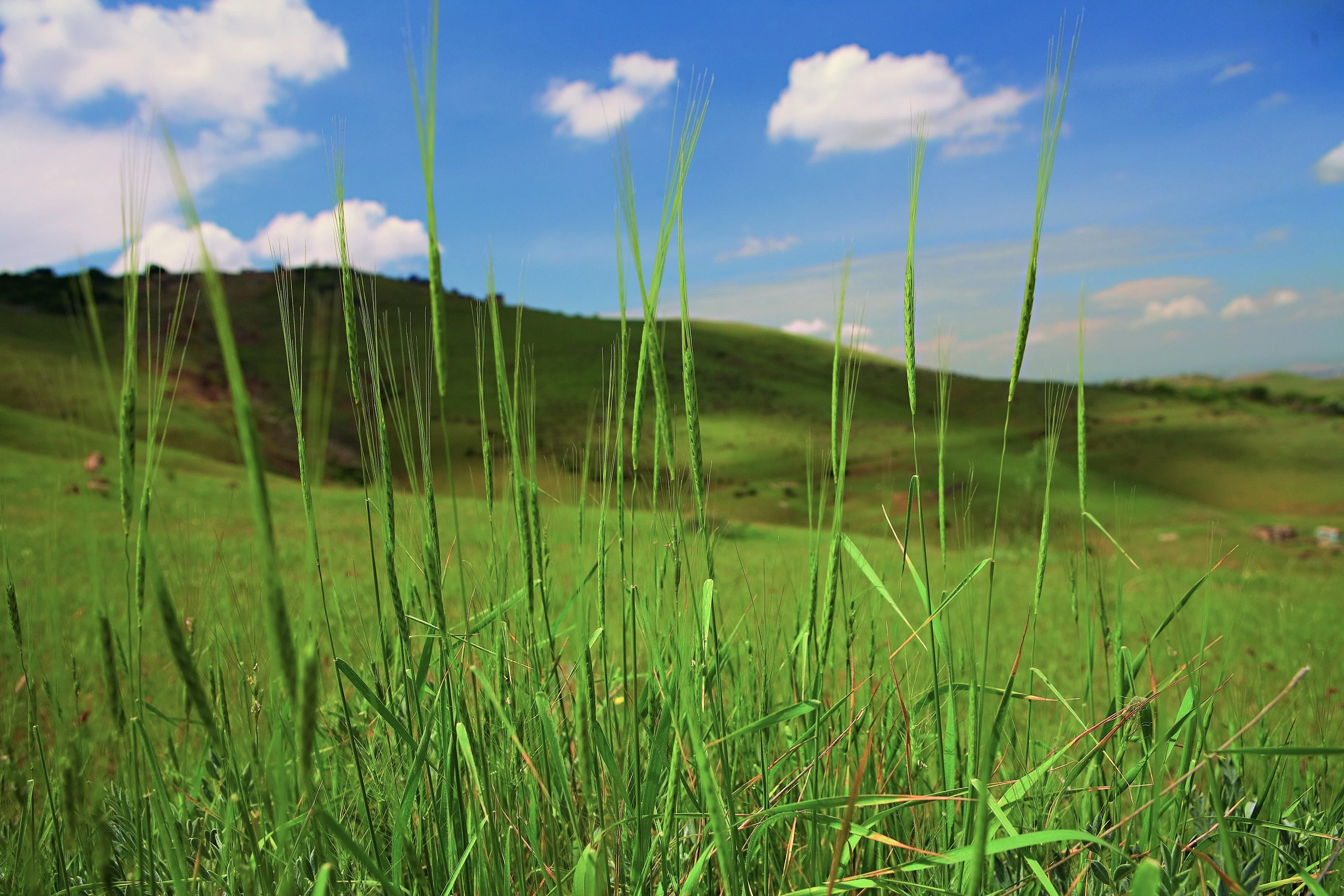
Close-up of wild grass stalks against a background of green rolling hills and a blue sky with white clouds.
Wild wheat species growing in the grasslands of Erebuni State Reserve.

Erebuni State Reserve history and protected-area timeline

Erebuni State Reserve was formally established in 1981 as a strict nature reserve under Armenian (then Soviet Armenian) nature protection administration, with the explicit purpose of conserving wild relatives of cultivated grasses, in particular wild species of wheat.

The reserve was tied administratively to the Erebuni District of Yerevan, where it occupies transitional semi-desert and mountain-steppe land southeast of the city center. For its first three decades, the reserve covered about 89 hectares.

In 2015, the reserve was expanded by 31 hectares through the addition of land in the nearby Voghjaberd area, bringing its total area to around 120 hectares. This expansion strengthened the protected buffer around the reserve's core wild wheat habitats and reinforced its role as a key site for the preservation of Armenia's native cereal genetic resources.

Throughout its history, Erebuni has been managed primarily as a scientific and conservation reserve rather than a public recreation site, and many of its protected plant species have been formally recognized in the Red Book of Armenia.

Erebuni State Reserve landscape and geographic character

Erebuni occupies a narrow strip of transitional terrain on the lower slopes that rise southeast of Yerevan. Its landscape sits at the meeting point between semi-desert lowlands and the mountain-steppe zones of the central Armenian highlands, creating a mosaic of dry, windswept slopes, shallow soils, and grassy ridges between roughly 1300 and 1450 meters above sea level.

The reserve's terrain is shaped by aridity and elevation rather than dramatic relief. Slopes are typically gentle to moderate, supporting mixed grass and shrub communities adapted to dry, continental conditions. The semi-desert character is reinforced by sparse vegetation cover, exposed mineral soils, and the presence of tough, drought-resistant plants.

As elevation increases toward the upper limit of the reserve, the landscape shifts gradually into mountain-steppe, where feather grasses and other bunchgrasses dominate. This thin transition band between two distinct ecological zones is what gives Erebuni its particular character and its importance for both plant diversity and the conservation of wild cereals.

Erebuni State Reserve ecosystems, habitats, and plant life

The reserve sits within a transitional ecological zone between true semi-desert and mountain-steppe, which gives it a rich and distinctive flora for its small size. Much of the area is dominated by feather-grass and wild cereal grasslands, with semi-desert shrubs such as thick-spiked sagebrush contributing to a sparse but specialized plant cover. Mountain chervil and various juniper species appear on the higher, slightly more mesic slopes.

The reserve's botanical significance lies overwhelmingly in its wild grass and wild wheat populations. Three of the four globally recognized wild wheat species grow in Erebuni, including Ararat wheat, Urartu wheat, and einkorn. The site also hosts a wide range of other wild grasses and relatives of cultivated cereals, as well as rare and endemic flowering plants. Seven plant species recorded in the reserve are listed in the Red Book of Armenia, and the site is considered a critical reservoir of plant genetic material for the wider region.

Erebuni State Reserve wildlife and species highlights

Erebuni supports a varied fauna for such a small reserve, thanks to its location at the interface of semi-desert and mountain-steppe habitats. Amphibians are well represented, with documented populations of species including the European green toad, the marsh frog, and the Syrian spadefoot toad.

Reptiles also make use of the warm, dry slopes, including various snake species, the Mediterranean turtle, and the Transcaucasian gypsum lizard. Birdlife includes species such as the grey partridge and other steppe-adapted birds, while mammals include foxes, wolves, martens, hares, and a range of rodent species that thrive in the grassland habitat.

While Erebuni is not primarily managed for large mammal conservation, its mosaic of habitats and proximity to wilder mountain areas allow it to play a supporting role for regional wildlife populations in central Armenia.

Erebuni State Reserve conservation status and protection priorities

Erebuni's conservation importance is heavily botanical and genetic rather than landscape-scale. The reserve was created to protect wild relatives of cultivated cereals, particularly wild wheats, and it remains one of the most important sites in the world for safeguarding the genetic diversity of these species. Its populations of wild Ararat, Urartu, and einkorn wheat, with rich intraspecific variation, make it a globally significant site for plant genetic resource conservation and for research into the origins of domesticated grain.

As a strict nature reserve under IUCN Category Ia, Erebuni is managed primarily for science and ecosystem preservation rather than for tourism or public access. The reserve's protected plant list includes seven species that are formally recognized in the Red Book of Armenia, and additional species such as Iris iberica subsp. elegantissima are also priorities for conservation.

The 2015 expansion of the reserve reinforced its conservation role by adding 31 hectares of adjacent land near Voghjaberd, extending protection around the core wild cereal habitats and improving long-term resilience for the site's fragile semi-desert and steppe plant communities.

Erebuni State Reserve cultural meaning and human context

Erebuni is closely tied to the cultural identity of Yerevan itself. The reserve takes its name from the Erebuni Fortress, the ancient Urartian foundation that gives the city of Yerevan its founding date, and the surrounding Erebuni District is named after the same historic site. This gives the reserve a symbolic connection to Armenia's deeper historical landscape, even though the protected area itself is valued for its natural rather than archaeological features.

The reserve also reflects a broader Armenian and Soviet-era tradition of creating small, strictly protected scientific reserves focused on specific natural values such as wild crop relatives, rather than large multi-use national parks.

Top sights and standout views in Erebuni State Reserve

One of the world's most important reserves for wild wheat conservation, harboring globally unique genetic diversity across three wild wheat species. A transitional semi-desert and mountain-steppe reserve where rare endemics and Red Book plant species coexist with wild cereal populations. A compact but scientifically rich strict nature reserve just outside Yerevan, offering a protected natural enclave near Armenia's capital.

Best time to visit Erebuni State Reserve

Erebuni is a working strict nature reserve and is not primarily oriented around casual visitation, so timing is best considered through the lens of seasonal ecological character rather than visitor convenience. Spring is the most biologically expressive season, when wild cereals, iris species, and other flowering plants are most visible and the semi-desert slopes briefly take on greener tones.

Late spring through early summer also generally offers the mildest combination of warmth and accessibility in this dry, continental climate. Late summer and autumn tend to be hotter and drier, with sparser vegetation, while winter can bring cold conditions and occasional snow at the reserve's elevations, transforming the landscape into a much more barren and windswept setting.
Monthly climate preview

Long-term monthly temperature and precipitation averages for Armenia

Erebuni State Reserve Climate Normals and Annual Temperature Patterns

Historical climate data from a representative elevation point reveals the measured annual rhythm of average temperatures and monthly precipitation values across Erebuni State Reserve. Exploring the complete twelve-month normals profile provides detailed context on long-term thermal ranges and precipitation patterns throughout the protected area.
Annual mean13 °C
0 °C27 °C
Jan
Feb
Mar
Apr13°
May18°
Jun23°
Jul27°
Aug27°
Sep22°
Oct15°
Nov
Dec
Warmest month
July

27.1 °C

Coolest month
January

-0.4 °C

Wettest month
May

1.7 mm/day

Driest month
February

0.5 mm/day

Park location guide

Geography guide, regional context, and park location map for Erebuni State Reserve

Erebuni State Reserve park geography, regions, and map view in Armenia

Understand where Erebuni State Reserve sits in Armenia through a broader geographic reading of the surrounding landscape, nearby location context, and its mapped position within the national park landscape.

How Erebuni State Reserve fits into Armenia

Armenia is a landlocked nation in the South Caucasus region of West Asia, located in the Armenian highlands. It shares borders with Turkey to the west, Georgia to the north, Azerbaijan to the east, and Iran and the Nakhchivan exclave to the south. Yerevan is the capital and largest city. Armenia was the first country to adopt Christianity as its official religion in AD 301 and maintains the Armenian Apostolic Church as its primary religious institution.

Wider geography shaping Erebuni State Reserve in Armenia

Armenia is situated in the South Caucasus region of West Asia, occupying the Armenian highlands. It is bordered by Turkey to the west, Georgia to the north, Azerbaijan to the east, and Iran and the Nakhchivan Autonomous Republic to the south. The country is landlocked, though it historically had access to the Caspian Sea.

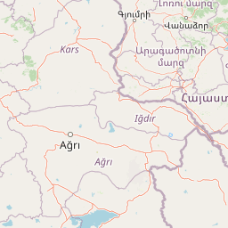
Map view of Erebuni State Reserve

Use this park location map to pinpoint Erebuni State Reserve in Armenia, understand its exact geographic position, and read its mapped placement within the surrounding landscape more clearly.

Pigeon | © OpenStreetMap contributors

Visualizing the semi-desert terrain, mountain-steppe habitats, and rare wild wheat ecosystems of Armenia

Erebuni State Reserve Landscape Photography and Protected Area Scenery

Photographic records reveal the distinct transitional terrain and delicate botanical habitats characterizing Erebuni State Reserve across its arid lower slopes. Visual documentation helps researchers and visitors examine the dry soils, native grasses, and protected ecosystems defining this upland natural enclave.

Close-up of wild grass stalks against a background of green rolling hills and a blue sky with white clouds.

Close-up of slender green stalks of wild wheat growing in a rolling grassy meadow under a partly cloudy blue sky.

Park atlas

Compare regional mountain-steppe habitats and adjacent conservation landscapes

Explore Protected Areas and Parks Near Erebuni State Reserve in Armenia

Browse other protected areas and national parks situated within the surrounding regional geography. Extending the search beyond Erebuni State Reserve reveals broader ecological patterns across the central highlands.
A horizontal watercolor painting depicting rolling green hills, distant mountains, and sparse vegetation.
Nature reserveArarat Province
About 7.5 km away#1 closest

Southeast

Khosrov Forest State Reserve: Mapping Armenia's Historic Nature Reserve and Mountain Geography

Explore ancient juniper forests and rugged canyon terrain in Ararat Province.

Khosrov Forest State Reserve is a critical protected landscape in Armenia defined by its remarkable elevational gradient. From semi-desert lowlands to high mountain meadows, the reserve encompasses unique Tertiary relict forests and river-cut gorges. This resource maps the park's boundaries and provides a clear geographic overview of its diverse ecosystems and cultural heritage within the Ararat Province.

Area
232.13 km²
Established
1958
IUCN
Ia
Relief
Mountain
A horizontal watercolor illustration depicting rolling, sandy desert dunes in the foreground and light purple, hazy mountain silhouettes in the background against a white sky.
Wildlife reserveArarat Province
About 31 km away#2 closest

South

Goravan Sands Sanctuary: Protected Sandy Semi-Desert Ecosystems in Ararat Province

A rare relict landscape of Armenia's Caucasus biodiversity

Goravan Sands Sanctuary preserves a striking mosaic of sandy plains, dry limestone ridges, and tertiary clay habitats within the Ararat Province. Known for hosting the only known Armenian population of the relict phog shrub, this reserve is a reference site for psammophilic flora and endemic invertebrate fauna. Explore the layered geography and arid biodiversity of this high-priority South Caucasus conservation landscape.

Area
0.96 km²
Established
1959
Relief
Upland
Climate
Arid
National parkGegharkunik Province
About 47 km away#3 closest

East

Sevan National Park: High-Altitude Lake and Protected Landscape in Gegharkunik

Explore map context, park boundaries, and regional geography.

Sevan National Park is a vital protected area located in Armenia's Gegharkunik Province, primarily safeguarding the remarkable high-altitude Lake Sevan. Established to protect this significant freshwater ecosystem, the park encompasses diverse surrounding landscapes including wetlands, forests, and steppes. Users exploring this canonical park detail page can delve into its geographic setting within the Armenian highlands, understand its importance as a protected landscape, and access structured data relevant to its unique natural environment. This MoriAtlas entry offers a focused lens on the park's conservation status and its contribution to regional geography.

Area
342 km²
Established
1978
IUCN
II
Relief
Highland
National parkTavush Province
About 58 km away#4 closest

Northeast

Dilijan National Park: Mapped Protected Landscape and Forested Terrain in Tavush Province

Explore ancient deciduous forests and medieval sites within this protected area.

Dilijan National Park offers a unique atlas perspective on Armenia's natural and cultural heritage. This protected landscape in Tavush Province is dominated by vast, ancient deciduous forests, including rare yew groves, making it a vital conservation area. Its mountainous terrain, carved by rivers and dotted with medieval monasteries like Haghartsin and Goshavank, provides a rich context for geographic discovery. Users can explore the park's mapped boundaries and understand its significance as a preserved woodland ecosystem within the Caucasus region through its detailed geographic information.

Area
240 km²
Established
2002
IUCN
II
Relief
Mixed relief
Nature reserveAzerbaijan
About 124 km away#5 closest

East

Gara-Gel State Reserve: Mapping the Protected Volcanic Landscapes of Azerbaijan

High-altitude nature reserve with glacial and volcanic crater geography.

Gara-Gel State Reserve represents a concentrated protected area built around Lake Ishigli-Gara-Gel. Situated at nearly 2,700 meters, this site showcases the convergence of volcanic geology and mountain botany. The landscape features meadows and steep slopes that define the character of this protected highland basin, offering significant insight into the transitional ecosystems found within the broader Karabakh plateau.

Area
2.4 km²
Established
1987
Relief
Mountain
Climate
Alpine
Watercolor illustration of rolling green fields, a lake, and distant hills under a sunset sky
National parkShirak Province
About 124 km away#6 closest

Northwest

Lake Arpi National Park: High-Altitude Wetland Protected Landscape in Shirak Province

Mapped boundaries of an important South Caucasus conservation area.

Lake Arpi National Park offers a unique window into high-altitude wetland ecosystems on the Shirak and Javakheti plateau, located at roughly 2000 meters above sea level. Established as a national park in 2009, it protects critical habitats, including the central Lake Arpi, and serves as a vital sanctuary for numerous bird species. This protected area is distinguished by its alpine meadows, significant bird populations, and its distinct geographic setting within Armenia's northwestern region, providing rich context for atlas-based exploration of protected lands.

Area
250 km²
Established
2009
IUCN
II
Relief
Mountain
Watercolor illustration of a lake surrounded by greenery with mountains in the background
National parkAzerbaijan
About 146 km away#7 closest

East

Göygöl National Park: Iconic Alpine Lakes and Protected Caucasus Forest Landscape

Explore Azerbaijan's most visited national park and its rich geographic context.

Göygöl National Park is a key protected area in Azerbaijan, renowned for the crystal-clear alpine Lake Göygöl and its surrounding dense forests within the Lesser Caucasus mountains. This national park showcases over 420 plant species, significant wildlife populations, and dramatic mountainous terrain, making it a prime destination for understanding regional landscape diversity and protected land value. Use MoriAtlas to explore its mapped boundaries and connect it to the broader geographic context of Azerbaijan.

Area
127.55 km²
Established
2008
IUCN
II
Relief
Mountain
Watercolor painting of green and pink mountain ranges under a light sky background
National parkSamtskhe–Javakheti
About 151 km away#8 closest

Northwest

Javakheti National Park: Protected Highland Landscape and Wetland Atlas

Explore the unique geography and mapped park boundaries of this Georgian protected area.

Delve into Javakheti National Park, a significant protected landscape located in Georgia's Samtskhe, Javakheti region. This page serves as an entry point for understanding the park's distinctive highland terrain, its remarkable chain of lakes and marshes, and its protected area status. Explore the geographic context of this national park, its role in wetland conservation, and its value for structured atlas-based discovery of natural landscapes.

Area
238.53 km²
Established
2011
IUCN
II
Relief
Mixed relief

Common questions about visiting, size, designation, and location context for Erebuni State Reserve

Erebuni State Reserve FAQs for park facts, access, geography, and protected area context

Find quick answers about Erebuni State Reserve, including protected-area facts, park geography, trail and visitor context, and how the park fits into its surrounding country and regional landscape.
MoriAtlas Explorer

Continue Your Protected Areas Search Across the Global Atlas

Deepen your exploration by continuing the structured search for national parks and protected areas worldwide. Utilize the comprehensive filtering capabilities to compare different conservation landscapes and refine your understanding of global park geography. Discover more about the distribution and characteristics of protected natural areas.

Global natural geography