Mori Atlas logo
National parkEl Palmar National Park

Discover the mapped park boundaries and regional landscape of this Argentinian national park.

El Palmar National Park: Protected Landscape Identity and Geographic Context in Entre Ríos Province

(Parque y Reserva Nacional El Palmar)

El Palmar National Park stands as a significant protected landscape within Argentina's Entre Ríos Province, a region nestled between the Paraná and Uruguay rivers. This page offers a detailed atlas-style exploration of the park's protected area identity, its mapped geographic extent, and its place within the broader natural terrain of the Mesopotamia region. Understand the unique character of this national park and its contribution to Argentina's network of protected lands through detailed mapping and geographic context.

Palm SavannaRamsar SiteGallery ForestNational ParkWetlandsTemperate Forest

El Palmar National Park

National park

Park overview

Structured park overview, official facts, and landscape profile for El Palmar National Park

El Palmar National Park park facts, protected area profile, and essential visitor context
Review the core facts for El Palmar National Park, including designation, size, terrain, visitor scale, habitats, and operating context in one park-focused overview.

About El Palmar National Park

El Palmar National Park occupies a distinctive place in Argentina's protected area system as a preservation anchor for the Espinal ecoregion's characteristic palm savanna ecosystem. The park lies in the department of Colón in eastern Entre Ríos Province, directly adjacent to the Uruguay River, with the national highway RN 14 forming part of its western boundary. The terrain consists of flat to gently rolling plains with highly variable soils that determine the distribution of different habitat types. The palm savanna, where yatay palms stand scattered through grassland, represents the park's signature landscape, but this gives way to xerophytic woodlands on drier sites, seasonally inundated wetlands and marshes (pajonales), and dense gallery forests along the river and stream margins. These gallery forests, or selvas en galería, contain a distinctly different flora more reminiscent of the Paranaense forest to the north, with abundant lianas, epiphytes, and moisture-loving tree species. The park is traversed by several streams including the Ubajay, Los Loros, Palmar, and Espino, all flowing east to join the Uruguay River. The climate is humid temperate without a dry season, with annual precipitation around 1,298 mm concentrated in spring and summer, and平均 temperatures around 18.9°C. El Palmar has been recognized internationally through its Ramsar designation and as an Important Bird Area, underscoring its significance for biodiversity conservation.

Quick facts and research context for El Palmar National Park

El Palmar National Park covers 8,213 hectares in Entre Ríos Province, Argentina, on the Uruguay River. The park was legally created in 1966 through Law 16802 and formally constituted in 1973. Its primary purpose is protecting the yatay palm (Butia yatay), a species native to the Espinal ecoregion. The park is part of the Ramsar wetland site Palmar Yatay since 2011 and is recognized as an Important Bird Area (AICA). The landscape features palm savanna, gallery forests along streams, xerophytic woodland, and wetlands. The park contains ruins of the Calera de Barquín, a historic limestone quarry operated by Jesuit missionaries from the 17th century.

Park context

Deeper park guide and search-rich context for El Palmar National Park

El Palmar National Park history, landscape, wildlife, and travel context
Explore El Palmar National Park through its history, landscape character, ecosystems, wildlife, conservation priorities, cultural context, and seasonal travel timing in a structured park guide built for atlas discovery and search intent.

Why El Palmar National Park stands out

El Palmar is best known for its remarkable yatay palm forests, which represent one of the most southerly natural palm groves on Earth. The park protects what remains of an ecosystem that once covered extensive areas of Entre Ríos, Santa Fe, Corrientes, and Chaco provinces before agricultural conversion devastated the palm populations. The distinctive landscape of scattered yatay palms across grassland creates an iconic savanna scene unique to this corner of Argentina. The park is also notable for its gallery forests along the Uruguay River and numerous streams, which support a rich diversity of wildlife in contrast to the surrounding agricultural plains. The presence of well-preserved historical ruins from the Jesuit-era Calera de Barquín adds cultural depth to the natural experience.

El Palmar National Park history and protected-area timeline

The history of El Palmar spans thousands of years of human occupation and centuries of colonial and post-colonial use before its protection. Archaeological evidence indicates the area supported settlements dating back around 1,000 years, associated with the yaros culture that later merged with charrua groups. Spanish military expeditions in the 1750s disrupted these indigenous communities. From 1650, Jesuit missionaries from the Reduction of Yapeyú established a limestone quarry (calera) at a site called Vuelta de San José, extracting organogenic limestone for shipment to Buenos Aires and Montevideo. After the Jesuits were expelled in 1768, the operation passed through various owners including Manuel Antonio Barquín, whose name the ruins still bear. In the early 19th century, a British agricultural company attempted to establish a wheat colony at the site, later followed by attempts to harvest yatay palm fruit. The land was eventually acquired by Justo José de Urquiza, a key figure in Argentine federalist history. By the mid-20th century, intensive agriculture and overgrazing had severely reduced the yatay palm forests, prompting botanical concerns from French naturalist Alcide d'Orbigny in 1827 and Belgian botanist Lucien Hauman in 1919, who proposed creating a reserve in 1923. Legislative attempts in 1945 and 1948 failed, but in 1960 the provincial government declared Butia yatay a protected species. The national park was finally established through Law 16802 in 1966, though formal constitution required additional legislative negotiations until 1973.

El Palmar National Park landscape and geographic character

The physical landscape of El Palmar presents a characteristic Mesopotamian savanna scene shaped by the interaction of flat to gently undulating terrain, seasonal waterlogging, and the distinctive yatay palm vegetation. The underlying geology includes sandstone outcrops that emerge at various points across the park, providing microhabitats for specialized species. The terrain's subtle topography creates a mosaic of environments: higher ground supports palm savanna and xerophytic woodland with species like ñandubay and espinillo, while lower areas become seasonally inundated marshes called pajonales. The most dramatic topographic variation occurs along the Uruguay River, where low riverbanks give way to bluffs reaching 15 meters in height in places. Gallery forests fringe the river and all streams, creating a distinct ecological corridor with dense vegetation, lianas, and epiphytes that contrasts sharply with the open savanna. The streams that cross the park, particularly the Palmar and Los Loros, carve shallow valleys that host wetlands and provide crucial habitat for water-loving species. The park's landscape is shaped by its location within the Espinal ecoregion, specifically the ñandubay district of the larger chaqueño phytogeographic domain, though elements of the pampeano and paranaense floras also appear.

El Palmar National Park ecosystems, habitats, and plant life

The ecological character of El Palmar is defined by its position within the Espinal ecoregion and the unique palm savanna ecosystem that is the park's defining feature. The yatay palm (Butia yatay) dominates the open savanna, forming a savanna-grassland matrix where palms stand amid native grasses and forbs, creating one of the most distinctive plant communities in southern South America. This palmar-pastizal ecosystem is intimately linked to the grassland, with the two forming a functional unit that supports countless animal species. Xerophytic woodlands occur on better-drained soils, featuring thorny species typical of the dry Chaco. The gallery forests along watercourses represent a different ecological community, containing elements of the Paranaense forest such as arrayán del norte and laurel, along with abundant epiphytes and climbing plants. Wetlands and marshes occupy the lower terrain, supporting aquatic vegetation and serving as critical habitat for amphibians, water birds, and semi-aquatic mammals. The park's biodiversity is substantial given its relatively modest size, with multiple threatened bird species, diverse mammals, and reptiles adapted to this transitional environment between the pampean grasslands and the subtropical forests to the north.

El Palmar National Park wildlife and species highlights

El Palmar supports a rich fauna that reflects the diverse habitats within the park, from the open palm savanna to the gallery forests and wetlands. The mammal community includes notable species such as the capybara, the world's largest rodent, which is commonly observed along streams and the Uruguay River. Crab-eating foxes inhabit the woodland and forest edges, while the more elusive pampas cat and Geoffroy's cat hunt in the savanna and forest understory. Vizcachas, large burrowing rodents, are abundant and their colonies are a visible feature of the landscape. The endangered yellow cardinal (Gubernatrix cristata) and several species of capuchin seedeaters represent the park's significant bird fauna, while the ñandú (Rhea americana) patrols the open grasslands. The湿地 support waterfowl including the muscovy duck, and the riverbanks provide habitat for the river otter and the coypu or coipo. Reptiles include the tegu lizard (Tupinambis teguixin) and various snakes. The park's bird checklist includes numerous species associated with the palm savanna and gallery forest habitats, making it a destination for birdwatchers interested in southern South American avifauna.

El Palmar National Park conservation status and protection priorities

El Palmar was created specifically to conserve the remaining yatay palm forests of Entre Ríos, representing one of the earliest and most significant conservation actions for this ecosystem type in Argentina. The park's establishment responded to documented declines of the yatay palm driven by agricultural conversion and overgrazing, which had eliminated most of the original palm forest that once covered thousands of square kilometers across multiple provinces. Today the park serves as a genetic reservoir and refuge for Butia yatay, a species that can live two to four centuries and whose long-term survival depends on protection of these remnant populations. The Ramsar designation in 2011 recognized the park's wetlands as internationally significant, particularly the riparian corridors and seasonal flooded areas that support unique biodiversity. The park is also designated as an Important Bird Area (AICA) due to the presence of globally or regionally threatened bird species. Management includes controlled burning to reduce wildfire risk, control of exotic species such as the invasive chinaberry tree (Melia azedarach), and management of exotic mammals including wild boar and axis deer that were introduced for hunting. A zoning system divides the park into zones of intensive use, extensive use, historical-cultural significance, recovery, and strict preservation (intangible).

El Palmar National Park cultural meaning and human context

The cultural dimension of El Palmar extends from pre-Columbian times through the colonial period to the present, with the park containing physical evidence of human occupation and use spanning centuries. Prior to European contact, the area was inhabited by indigenous groups of the yaros culture, later incorporated into charrua groups, with archaeological evidence of settlements around 1,000 years old. The most prominent historical feature is the Calera de Barquín, ruins of a limestone quarry and processing operation established by Jesuit missionaries from the Yapeyú mission around 1650. The Jesuits extracted limestone from this organogenic limestone deposit, shipping it via the Uruguay River to Buenos Aires and Montevideo. After the Jesuit expulsion in 1768, the quarry continued under various private owners, eventually including a British agricultural colony attempt in the 1820s and operations by Justo José de Urquiza in the mid-19th century. A battle during the Jordanist rebellion occurred at the site in 1873. The historical area is now preserved within the park, with ruins including a distillery, stone house, lookout, chapel, and cemetery. The park's administration is headquartered in a historic ranch house built in 1902 that belonged to Estela Sauviet, heir of Justo José de Urquiza, a former president of Argentina.

Top sights and standout views in El Palmar National Park

El Palmar National Park offers visitors a distinctive combination of iconic palm savanna scenery, wildlife viewing opportunities, and historical exploration within a well-managed protected area. The yatay palm groves, particularly beautiful at sunset when the palms are silhouetted against the horizon, represent the park's most characteristic visual feature and one of the southernmost palm forests on the planet. Well-maintained trails lead to viewpoints over the Los Loros and El Palmar streams, through the Yatay palm forest, and to the historic Calera de Barquín ruins. Two bird observatories established in 2008 provide dedicated birdwatching opportunities, while the gallery forests along the Uruguay River offer encounters with species difficult to see elsewhere in the region. The park's camping area provides direct access to the river, and canoe excursions allow exploration of the stream systems and even a nearby island. The combination of natural beauty, ecological significance, and historical depth makes El Palmar one of Argentina's most visited and beloved national parks.

Best time to visit El Palmar National Park

El Palmar can be visited year-round, though the optimal period for experiencing the park's character depends on visitor interests. The warm months from October through March coincide with the primary visitor season, when the grasslands are green and wildlife is active, though this is also the period of highest rainfall. Spring and early summer (October through December) bring flowering of many plant species and active bird behavior, making this an excellent time for wildlife observation and photography. Autumn and winter (May through August) offer a different character, with the grasslands turning golden and fewer visitors, though temperatures can be cool and occasional frosts occur between May and October. The park's camping facilities operate year-round. Visitors seeking to avoid crowds might consider weekdays or the winter months, while those interested in birdwatching should note that the two observatories are positioned to observe feeding and nesting activity which varies seasonally.
Park location guide

Geography guide, regional context, and park location map for El Palmar National Park

El Palmar National Park park geography, regions, and map view in Argentina
Understand where El Palmar National Park sits in Argentina through a broader geographic reading of the surrounding landscape, nearby location context, and its mapped position within the national park landscape.

How El Palmar National Park fits into Argentina

Argentina is a federal republic located in the southern cone of South America, bordering Chile, Bolivia, Paraguay, Brazil, Uruguay, and the Atlantic Ocean. With an area of 2,780,085 km², it is the second-largest country in South America and the eighth-largest globally. The capital and largest city is Buenos Aires, and the official language is Spanish. The country claims sovereignty over the Falkland Islands, South Georgia and the South Sandwich Islands, and a portion of Antarctica.

Wider geography shaping El Palmar National Park in Argentina

Argentina occupies the southern portion of South America, sharing the Southern Cone region with Chile to the west. The country borders Bolivia and Paraguay to the north, Brazil to the northeast, Uruguay and the South Atlantic Ocean to the east, and the Drake Passage to the south. The Andes mountain range runs along the western border, while the Pampas plains dominate the central region. Argentina also claims territories in Antarctica.

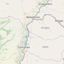
Map view of El Palmar National Park

Use this park location map to pinpoint El Palmar National Park in Argentina, understand its exact geographic position, and read its mapped placement within the surrounding landscape more clearly.

Pigeon | © OpenStreetMap contributors

Location context for El Palmar National Park

Entre Ríos Province
Park atlas

Uncover the Surrounding Protected Landscapes and Compare Regional Park Geography

Explore Other National Parks and Protected Areas Near El Palmar National Park
Explore additional national parks and protected areas in the region surrounding El Palmar National Park, tracing a wider network of conserved yatay palm forests, grasslands, and riverine landscapes. Compare diverse protected natural areas by their unique ecologies and geographic features across this corner of Argentina, moving beyond one specific park view.
National parkEntre Ríos Province

Predelta National Park: Mapped Boundaries and Protected Wetland Geography in Entre Ríos

Explore the unique river island ecosystems and dynamic delta landscape.

Predelta National Park stands as a critical protected landscape at the initial stages of the vast Paraná Delta, located in Argentina's Entre Ríos Province. This national park is defined by its intricate network of lagoons, natural levees, and forested islands, showcasing a transition zone where the river fragments into a complex wetland ecosystem. Understanding Predelta National Park involves exploring its mapped geography, its role in the Paraná River's delta formation, and its significance as a protected natural area vital for regional biodiversity and ecological processes.

Area
24.58 km²
Established
1992
IUCN
II
Relief
Lowland
National parkCorrientes Province

Iberá National Park: National Park Atlas Exploration in Corrientes Province

Mapped protected area context and regional geography.

Delve into the atlas view of Iberá National Park, a designated national park situated in Corrientes Province, Argentina. This detailed entry clarifies the park's protected landscape identity and its contribution to the regional geography of northeastern Argentina. Understand its mapped boundaries and explore its significance as a conservation area within the Mesopotamia region.

Area
1,835 km²
Established
2018
IUCN
II
Relief
Lowland
National parkCorrientes Province

Mburucuyá National Park: National Park in Corrientes Province, Argentina

Iconic yatay palm savannas and diverse wetland ecosystems.

As a key national park within Argentina's Corrientes Province, Mburucuyá National Park offers a unique atlas-scale view of ecological convergence. It preserves expansive yatay palm savannas, critical wetland habitats within the Iberá Wetlands, and lush subtropical forests. The park's boundaries define an area where the Humid Chaco, Espinal, and Selva Paranaense biomes meet, creating a landscape of exceptional biodiversity and geographic significance for regional conservation and mapped exploration.

Area
176.82 km²
Established
2001
IUCN
II
Relief
Lowland
National parkRocha Department

Santa Teresa National Park: Mapped Coastal Forest and Beach Protected Landscape

Explore Rocha Department's unique protected Atlantic coast geography.

Santa Teresa National Park, a designated national park in Uruguay's Rocha Department, offers a compelling example of a protected coastal environment. Its landscape is characterized by a distinctive blend of dense forests that reach down to the sandy shores of the Atlantic Ocean, a rare feature in the region's protected areas. This page provides detailed geographic context and map-based exploration for understanding this unique seaside national park and its place within Uruguay's conservation atlas.

IUCN
II
Relief
Lowland
Climate
Subtropical
Access
Easy access
National parkBuenos Aires Province

Campos del Tuyú National Park: National Park Protected Area and Landscape Context

Mapped boundaries and regional geography for this Buenos Aires Province natural reserve.

Campos del Tuyú National Park represents a protected landscape within Argentina's Buenos Aires Province, offering a focused point for atlas-driven exploration. This entry details the park's designation as a national park, providing insights into its mapped geographic scope and its contribution to the regional natural landscape. Understand the foundational elements of this protected area for comparative geography and a structured understanding of conservation lands.

Area
30.4 km²
Established
2009
IUCN
II
Relief
Lowland
National parkChaco Province

Chaco National Park: Protected Landscape and Regional Geography Atlas

Explore mapped boundaries within the Eastern Chaco's unique ecosystem.

Chaco National Park is an important protected area in Chaco Province, Argentina, dedicated to preserving the unique Eastern Chaco ecosystem. Covering 150 square kilometers, its landscape comprises warm lowland terrain with scrubland, savanna, swamp areas, and scattered lakes. This national park is recognized for its efforts to conserve the distinctive quebracho forests and supports a rich array of wildlife, making it a key site for understanding regional protected-area geography and landscape context.

Area
150 km²
Established
1954
IUCN
II
Relief
Lowland
National parkCórdoba Province

Quebrada del Condorito National Park: Mapped Protected Landscape and Biological Island Ecosystem

Argentina National Park in Córdoba Province

Quebrada del Condorito National Park is a federally protected area in Argentina's Córdoba Province, established to safeguard a significant portion of the Sierras Pampeanas mountain ecosystem. The park's rugged terrain, including deep gorges and high-altitude plateaus, creates a distinct biological island environment supporting a wealth of endemic species. Its geographic isolation and dramatic landscape make it a unique focus for protected-area discovery and understanding Argentina's natural geography.

Area
373.44 km²
Established
1996
IUCN
II
Relief
Mountain
National parkItapúa Department

San Rafael National Park: National Park Protected Landscape & Geographic Overview

Discover the mapped boundaries and regional setting in Itapúa.

San Rafael National Park is a significant protected area designated as a national park in Paraguay's Itapúa Department. This page serves as an atlas-centric entry point, offering a detailed view of its geographic scope, mapped park boundaries, and its role as a conservation landscape. Users can explore the park's terrain and its place within the regional geography for a structured understanding of its protected status.

Area
693.04 km²
Established
1992
IUCN
II
Relief
Upland

Common questions about visiting, size, designation, and location context for El Palmar National Park

El Palmar National Park FAQs for park facts, access, geography, and protected area context
Find quick answers about El Palmar National Park, including protected-area facts, park geography, trail and visitor context, and how the park fits into its surrounding country and regional landscape.
MoriAtlas Explorer

Continue Your Protected Areas Search Across the Global Atlas

Deepen your exploration by continuing the structured search for national parks and protected areas worldwide. Utilize the comprehensive filtering capabilities to compare different conservation landscapes and refine your understanding of global park geography. Discover more about the distribution and characteristics of protected natural areas.

Global natural geography