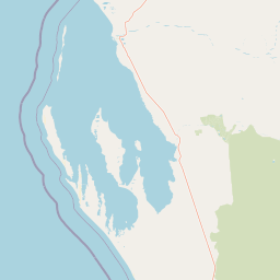
Why Faure Island stands out
Faure Island is best known as a seabird breeding stronghold and an island rewilding success story set within the Shark Bay World Heritage landscape. Together with the adjacent tiny Pelican Island, it has been recognised as an Important Bird Area because of its colonies of fairy terns and the presence of internationally significant numbers of red necked stints and pied oystercatchers on the East Asian Australasian Flyway. The island is equally valued as a conservation site where native mammals extirpated by historical grazing, including the boodie, Shark Bay mouse, banded hare wallaby, and western barred bandicoot, have been reintroduced into predator controlled habitat. Its location within the Shark Bay Marine Park and next to the Wooramel Seagrass Bank and the Faure Sill gives it additional importance as a land based counterpoint to one of the world's most distinctive marine ecosystems.
Faure Island history and protected-area timeline
The island's European name was given by the French explorer Nicolas Baudin in 1801, naming it after Pierre Faure, a geographer aboard the corvette Le Naturaliste during Baudin's expedition to the Australian coast. The name reflects the strong French exploration legacy in the Shark Bay region, which also includes nearby features such as the Peron Peninsula and Freycinet Island.
Pastoral use of Faure Island began in the late nineteenth century. Leases were granted to Charles Broadhurst in 1873 and to WD Moore and Company in 1883, and from 1905 the Hoult family of Denham ran sheep and goats on the island for most of the twentieth century. This long period of livestock grazing, combined with the presence of feral cats, led to the loss of much of the island's original native mammal fauna.
In 1999 the Hoults sold the lease to the Australian Wildlife Conservancy. One of the first actions of the new owners was to remove more than 3400 sheep from the island, ending the pastoral era and beginning the transformation of the property into a nature reserve, the Faure Island Sanctuary. Programs to control feral predators and to reintroduce locally extinct native mammals quickly followed, marking a clear shift from grazing enterprise to active conservation management.
Faure Island landscape and geographic character
Faure Island has a low and gently undulating terrain typical of the arid coastal zone of Shark Bay. Red and white sandy plains and dunes dominate much of the island, broken up by claypans in shallow depressions that briefly fill with water after rainfall. The highest point only reaches about 26 metres above sea level, so the landscape reads as broad, open, and exposed rather than rugged.
The shoreline is varied. In places the coast is marked by limestone outcrops and red sand cliffs similar in character to those of the nearby Peron Peninsula, while elsewhere the fringe softens into tidal flats and mangrove lined shallows. These transitions between dune, cliff, and mangrove are important for both wildlife movement and habitat diversity.
Despite the modest elevation, the combination of sand plains, claypans, cliff shores, and mangrove estuaries creates a layered landscape in which marine, littoral, and arid inland environments meet. The Faure Sill sandbank offshore, and the broader waters of Shark Bay surrounding the island, complement the terrestrial scenery with one of the most distinctive marine seascapes in Australia.
Faure Island ecosystems, habitats, and plant life
The natural environment of Faure Island is defined by the overlap between arid shrubland ecosystems and a highly productive marine setting. Vegetation is dominated by low shrublands of Acacia ramulosa, with mallee shrublands, spinifex grasslands, and stands of samphire and Atriplex shrubs on more saline substrates. Mangroves occupy the intertidal fringe and link the island's terrestrial ecosystems to the productive waters of Shark Bay.
These habitat types support a distinctive ecological community adapted to low rainfall, saline soils, and seasonal extremes. Acacia and mallee shrublands provide shelter and food for small marsupials and reptiles, while samphire flats and mangrove edges are important for shorebirds and seabirds. Claypans and seasonal wet areas create ephemeral resources for waterbirds and invertebrates.
The island's nature is inseparable from its marine context. The waters around Faure Island form part of the Shark Bay Marine Park and the Shark Bay World Heritage Site, encompassing seagrass meadows, the Wooramel Seagrass Bank, and the Faure Sill. This juxtaposition of arid terrestrial habitat and globally significant marine ecosystems gives the sanctuary a particularly rich ecological character.
Faure Island wildlife and species highlights
Faure Island is internationally recognised for its birdlife. Together with the much smaller Pelican Island and their associated mudflats, it forms a designated Important Bird Area of about 5821 hectares, valued for breeding seabirds and for migratory waders moving along the East Asian Australasian Flyway. The island supports breeding colonies of fairy terns, and congregations of red necked stints and pied oystercatchers that exceed one percent of their global populations.
In combination with the nearby Quoin Bluff and Freycinet Island Important Bird Area, the broader area around Faure Island also supports more than one percent of the global population of pied cormorants. The island's position on a major migratory pathway, its mix of mangrove, samphire, mudflat, and open sandy habitats, and the productivity of Shark Bay's waters combine to make it a key point for both resident and visiting bird species.
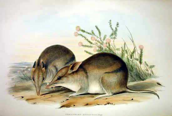
Mammal conservation is the other defining wildlife story at Faure Island. The original native mammal fauna was lost during more than a century of livestock grazing and the presence of feral cats. Sub fossil remains in the island's sediments revealed the former presence of small marsupials and rodents, providing a scientific basis for reintroduction programs. The boodie, Shark Bay mouse, banded hare wallaby, and western barred bandicoot have all been reintroduced, while an attempt to restore the greater stick nest rat was unsuccessful. Today the island is best known for growing populations of western barred bandicoots and other native mammals in a landscape that is being actively managed for their recovery.
Faure Island conservation status and protection priorities
Faure Island sits within one of the most strongly protected marine and coastal frameworks in Australia, embedded in the Shark Bay Marine Park and the Shark Bay World Heritage Site. Its land tenure as a pastoral lease combined with formal nature reserve status, and its ownership and management by the Australian Wildlife Conservancy, give it a unique conservation profile: a privately managed sanctuary operating within a public system of marine and world heritage protections.
The removal of more than 3400 sheep in 1999 was a turning point for the island's ecology, ending the grazing era and allowing the slow recovery of native vegetation. Subsequent investment in feral predator control created the conditions for the reintroduction of locally extinct native mammals, including the boodie, Shark Bay mouse, banded hare wallaby, and western barred bandicoot. Although the reintroduction of the greater stick nest rat has so far failed, the island has become a working example of island rewilding in an arid setting.
Faure Island also contributes to marine conservation at a landscape scale. Its proximity to the Wooramel Seagrass Bank and the Faure Sill makes the island a terrestrial anchor for protecting the conditions that drive Shark Bay's remarkable ecology, including the exceptional seagrass meadows and the stromatolites of Hamelin Pool. The sanctuary therefore matters both for the species it shelters directly and for the broader ecological processes of Shark Bay.
Faure Island cultural meaning and human context
The European cultural history of Faure Island is closely tied to early French scientific exploration along the Western Australian coast. Nicolas Baudin's 1801 naming of the island after his colleague Pierre Faure reflects the strong French influence on the toponymy of the Shark Bay region, evident also in names such as the Peron Peninsula and Freycinet Island.
The pastoral era from the 1870s to the late twentieth century, beginning with leases to Charles Broadhurst and WD Moore and Company and extending through more than ninety years of management by the Hoult family from Denham, forms another important layer of the island's human story. This long association with sheep and goat grazing shaped the landscape and the loss of native fauna, providing the context in which the 1999 transition to conservation management took place.
Top sights and standout views in Faure Island
One of Faure Island's strongest highlights is its status as part of a declared Important Bird Area, supporting fairy tern breeding colonies and internationally significant numbers of migratory waders along the East Asian Australasian Flyway. A second highlight is the active rewilding program that has restored populations of boodies, Shark Bay mice, banded hare wallabies, and western barred bandicoots, turning an overgrazed pastoral lease into a functioning arid zone sanctuary.
The island's setting within the Shark Bay Marine Park and the Shark Bay World Heritage Site adds a third layer of distinction, situating its terrestrial habitats among some of the most celebrated seagrass meadows and stromatolite formations on Earth. Combined, these qualities make Faure Island a compact but ecologically dense component of Shark Bay's wider natural significance.
Best time to visit Faure Island
Faure Island has a semi arid to arid climate in which seasons strongly shape the character of a visit. Winters are mild and bring the most reliable rainfall, often expressed through greener vegetation, more active bird behaviour, and the seasonal presence of migratory waders concentrating on the mudflats and shoreline. This makes the cooler months broadly the most rewarding period for birdwatching and general nature observation.
Summers are hot and dry, with limited rainfall and high evaporation, which can leave the landscape looking harsh and dusty, though tropical cyclones occasionally deliver sudden heavy rain that transforms claypans and shrublands over short periods. Any visit should recognise that wildlife activity on the island is strongly influenced by rainfall, tide, and season rather than by fixed schedules.