Mori Atlas logo
Protected landscapeFokstugu landskapsvernområde

Mapping the ecological connectivity and cultural heritage of this vital Norwegian alpine region.

Fokstugu landskapsvernområde: A Strategic Protected Mountain Landscape on the Dovrefjell Plateau

Fokstugu landskapsvernområde serves as a critical protected landscape within the Dovrefjell mountain region of Innlandet, Norway. Spanning open mountain terrain and protected geological formations, the area functions as an essential ecological bridge between larger national parks. This geography supports ancient wild reindeer migration corridors while preserving traditional cultural landscapes, including historic mountain summer farm settlements and pastoral hay meadows.

alpine landscapeprotected landscapewild reindeer corridormountain plateaucultural landscapesetter heritage

Fokstugu landskapsvernområde

Protected landscape

Park overview

Structured park overview, official facts, and landscape profile for Fokstugu Landscape Protection Area

Fokstugu Landscape Protection Area park facts, protected area profile, and essential visitor context

Review the core facts for Fokstugu Landscape Protection Area, including designation, size, terrain, visitor scale, habitats, and operating context in one park-focused overview.

About Fokstugu Landscape Protection Area

Fokstugu Landscape Protection Area is a defined stretch of high mountain landscape between two of Norway's largest national parks. Created in 2002, it sits on either side of the E6 highway as it climbs over the Dovrefjell massif, a high plateau region long considered one of the gateways to Scandinavian alpine wilderness. The area is administered under Norwegian landscape protection area rules, which place special emphasis on maintaining the character of the surrounding natural and cultural environment rather than on strict nature reserve conditions.

The geographical setting is fundamental to the area's importance. The protection area extends across parts of Dovre and Lesja municipalities in what is now Innlandet county, with the closest major settlement at Dombås. It effectively surrounds the Fokstumyra nature reserve, which is ecologically distinct as a wetland of its own, and acts as a bridge between two internationally recognised protected regions. To the south lies Dovre National Park; to the north lies Dovrefjell-Sunndalsfjella National Park. The neighbouring Vesle Hjerkinn Landscape Protection Area plays a similar bridging role further along the same mountain block, and together these zones help form an almost continuous protected belt from Sunndalsfjella in the northwest to Ringebufjellet in the southeast.

What makes Fokstugu particularly significant is the combination of biodiversity value, cultural landscape, and ecological connectivity. Part of one of the last wild reindeer populations in Northern Europe still moves through this region, and the boundaries of the protection area were drawn specifically to enable restoration of the traditional migratory route between southern and northern seasonal ranges. At the same time, the terrain contains distinctive geological features, cultural heritage sites linked to transhumance farming, and open vistas typical of the central Norwegian highlands. The result is a layered mountain landscape that functions simultaneously as a wildlife corridor, a cultural heritage area, and a scenic alpine environment.

Quick facts and research context for Fokstugu Landscape Protection Area

Fokstugu Landscape Protection Area was established in 2002 and lies within Dovre and Lesja municipalities in Innlandet county, Norway. It covers about 72.3 square kilometres of high-mountain terrain straddling the E6 road across the Dovrefjell massif. The protected area surrounds the smaller Fokstumyra nature reserve and adjoins both Dovre National Park to the south and Dovrefjell-Sunndalsfjella National Park to the north.

The area is administered by the Dovrefjell National Park Board, with public information provided through the Nasjonalparker national park centre network, including centres at Dombås, Folldal, Kvikne, and Sunndal. The site contributes to one of the largest connected protected mountain regions in Scandinavia and is a key element in safeguarding the last remaining population of wild reindeer in Northern Europe.

Protection and recognition

Documented terrestrial protection scope and administrative recognition history

Fokstugu landskapsvernområde Protection Status and Designation Records

Fokstugu landskapsvernområde maintains a documented terrestrial protection scope within the regional protected area network. Administrative records outline the official conservation status and administrative designation framework governing the terrain.

Protection details

Protection scope
Terrestrial
Transboundary protection
No
Park context

Deeper park guide and search-rich context for Fokstugu Landscape Protection Area

Fokstugu Landscape Protection Area history, landscape, wildlife, and travel context

Explore Fokstugu Landscape Protection Area through its history, landscape character, ecosystems, wildlife, conservation priorities, cultural context, and seasonal travel timing in a structured park guide built for atlas discovery and search intent.

Why Fokstugu Landscape Protection Area stands out

Fokstugu is best known as a connective wildlife corridor on the Dovrefjell plateau, with landscape protection status designed to allow the ancient seasonal migration of wild reindeer between their summer and winter ranges. It is also valued for its combination of cultural mountain landscape features, including old summer farm settlements, hay meadows, and visible traces of seasonal grazing culture that remain part of the Norwegian highland heritage. Equally important is its geological character, with formations and landscape features in the protection area recognised as worthy of preservation in their own right. Combined with its role in linking Dovre and Dovrefjell-Sunndalsfjella national parks, the area's identity rests as much on function as on scenery.
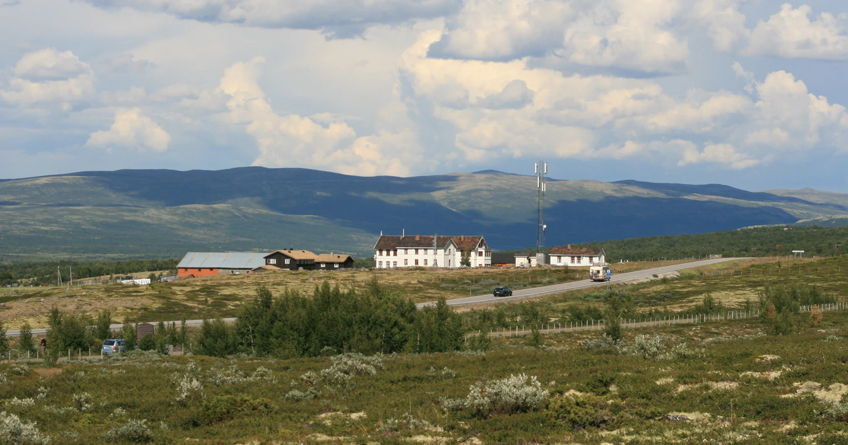
A wide view of the Fokstugu mountain lodge complex, characterized by several traditional buildings set within a rolling, shrub-covered moorland with mountains in the background.
The historic Fokstugu mountain lodge situated in the mountain landscape of Dovre, Norway.

Fokstugu Landscape Protection Area history and protected-area timeline

Fokstugu Landscape Protection Area was formally established in 2002 as part of a broader Norwegian strategy to strengthen ecological connectivity across the central Scandinavian mountains. Its creation followed growing awareness that the wild reindeer population of the Dovrefjell region needed continuous, functionally intact habitat if long-term survival of the herd was to be assured.

The protection area's boundaries were deliberately shaped to surround the existing Fokstumyra nature reserve and to fill the ecological gap between Dovre National Park to the south and Dovrefjell-Sunndalsfjella National Park to the north. This planning also extended to coordinating protection with the Vesle Hjerkinn Landscape Protection Area, so that the migrating reindeer could potentially traverse a much wider continuous protected landscape. The area's administrative framework was placed under the Dovrefjell National Park Board, and public information services were integrated into the Nasjonalparker national park centre network, with information points at Dombås, Folldal, Kvikne, and Sunndal.

In addition to the wildlife conservation rationale, the protection recognised the long history of human use of the plateau. Summer mountain farming, seasonal dairy production, and the associated cultural features of seter settlements and hay meadows had shaped the cultural landscape of the Fokstugu area over centuries. By designating the zone as a landscape protection area rather than a strict national park, the regime allowed traditional low-impact outdoor recreation and continued cultural land use to coexist with conservation goals, including the gradual restoration of reindeer movement between southern and northern ranges.

Fokstugu Landscape Protection Area landscape and geographic character

The landscape of Fokstugu is characteristic of the high Dovrefjell plateau in central Norway. Broad open mountain terrain dominates the area, with wide valleys, gentle alpine ridges, and elevated plains traversed by the E6 corridor. Although it does not form the highest peaks in the region, it occupies a strategic position on the mountain block, making it a true transitional landscape between the deeper alpine zones of the larger national parks on either side.

Geological features form a significant part of the area's character. The terrain displays noticeable variation in surface forms, soils, and exposed rock structures that have been identified as having conservation value in their own right. These features reflect the broader geological story of the Dovrefjell region, where ancient mountain foundations and glacial history combine to produce distinctive alpine landforms.

Embedded in this broader setting are cultural landscape elements such as seter settlements, pasture outlines, and traditional hay meadows. These softer, human-shaped features add a cultural texture to the otherwise open mountain scenery and illustrate how centuries of seasonal farming have shaped parts of the plateau. Together, the wild alpine expanses, the geological formations, and the cultural farming traces give Fokstugu a landscape identity that is both natural and historical.

Fokstugu Landscape Protection Area ecosystems, habitats, and plant life

Ecologically, Fokstugu falls within the alpine and sub-alpine zones of central Scandinavia. The dominant vegetation pattern is typical open mountain heath and grassland, with vegetation adapted to a short growing season and a harsh climate. The area functions primarily as connective habitat rather than as a self-contained wilderness block, which fundamentally shapes its ecological value.

The most meaningful ecological role of the area is to allow movement of wildlife across the mountain block. By maintaining habitat continuity between the national parks to the north and south, Fokstugu contributes to the broader ecological coherence of the Dorrefjell ecosystem. The surrounding Fokstumyra nature reserve adds a further dimension of ecological contrast, introducing wetland habitat patterns that differ strongly from the surrounding dry alpine terrain.

The objective of maintaining habitat quality for wide-ranging alpine species is central to how the area is managed. Protection status here is aimed less at isolating an ecosystem and more at preserving an ecologically functional mountain landscape in which traditional low-intensity land use can continue alongside the needs of migrating wildlife.

Fokstugu Landscape Protection Area wildlife and species highlights

The wildlife significance of Fokstugu centres overwhelmingly on wild reindeer. The mountain block on which the protection area sits supports part of one of the last remaining wild populations of reindeer in Northern Europe, a population of high international conservation importance. The boundaries of the protection area were drawn explicitly to keep this migratory route available, recognising that the long-term survival of the herd depends on access to traditional seasonal ranges.

Beyond reindeer, the area contributes to broader alpine wildlife patterns that characterise the Dovrefjell region. The mountain environment supports typical Scandinavian alpine fauna adapted to open terrain, harsh winters, and patchy vegetation. While the area is not framed as a species-rich core habitat in the way a strict nature reserve might be, its function as migratory and connective habitat gives it disproportionate value for the wider mountain ecosystem, including species that move seasonally across the plateau.

Fokstugu Landscape Protection Area conservation status and protection priorities

The conservation purpose of Fokstugu differs in emphasis from that of a strict national park or nature reserve. As a landscape protection area, it is intended to preserve the integrated character of an extensive mountain landscape, including both natural processes and cultural land use, while preventing fragmentation that would compromise ecological function.

At the heart of the conservation rationale is the preservation of the wild reindeer population and its traditional migratory routes. Norway's central mountain reindeer are among the last truly wild reindeer in Northern Europe, and maintaining landscape connectivity has been the primary driver of much of the region's modern conservation planning. Fokstugu's contribution to this system is therefore not only local but strategic, reinforcing the ecological integrity of the wider Dovrefjell-Sunndalsfjella-Dovre protected complex.

Additional conservation significance comes from the area's geological heritage, with specific formations identified as worthy of protection, and from its cultural landscape features. By embedding these values within a single designation, the protection area helps ensure that future management of the plateau must account for geology, ecology, and cultural heritage together rather than in isolation.

Fokstugu Landscape Protection Area cultural meaning and human context

The cultural identity of Fokstugu is rooted in the centuries-old tradition of mountain summer farming in central Norway. The area contains seter settlements and associated cultural features such as hay meadows, pasture boundaries, and traces of seasonal dwellings, reflecting a way of life in which livestock moved to upland pastures during the warmer months. These features are not incidental; they are recognised as part of the reason the landscape itself is considered worth protecting.

The use of the landscape protection area designation rather than a stricter reserve category reflects an explicit decision to allow traditional low-impact land use to continue. Walking, hiking, and other forms of simple outdoor recreation are encouraged as long as they remain light-touch, and the area is intended to support both ecological function and continuing human presence. This balance is part of a broader Norwegian approach to mountain management, in which cultural landscape values are seen as inseparable from the region's natural heritage.

Top sights and standout views in Fokstugu Landscape Protection Area

Fokstugu is notable for sitting at the intersection of three major conservation priorities: wild reindeer migration corridors, cultural mountain landscapes, and geological heritage. Its function as a bridge between two of Norway's largest mountain national parks gives it a strategic significance that exceeds its standalone size.

The combination of open alpine scenery, preserved seter culture, and protected geological formations makes the area distinctive within the wider Dovrefjell region. Its boundary around Fokstumyra also adds a wetland dimension, while its accessibility via the E6 corridor across Dovrefjell gives it a presence in the everyday experience of travellers through central Norway, even for those who only glimpse it in passing.

Best time to visit Fokstugu Landscape Protection Area

Fokstugu is best experienced during the snow-free months, when the alpine landscape opens up and the cultural features of the mountain summer farms become accessible. Late spring through early autumn typically offers the most rewarding conditions for hiking and for appreciating both the open scenery and the cultural traces of traditional summer farming.

The reindeer migratory cycle also shapes the character of a visit. Seasonal movement of animals between southern and northern ranges influences where wildlife may be encountered across the mountain block. Visitors seeking a quieter alpine experience may find shoulder seasons preferable, while summer offers the fullest access to the area's combined natural and cultural landscape.
Monthly climate preview

Long term monthly averages for temperature and precipitation at representative elevations

Fokstugu landskapsvernområde Climate Normals and Temperature Rhythms

Representative coordinates record long term temperature variations and monthly precipitation rates across the landscape throughout the year. Examining the full twelve month climatology profile provides deeper analytical insight into sustained regional normals.
Annual mean-2 °C
-10 °C10 °C
Jan-10°
Feb-10°
Mar-8°
Apr-4°
May
Jun
Jul10°
Aug
Sep
Oct-2°
Nov-7°
Dec-10°
Warmest month
July

10 °C

Coolest month
January

-10.5 °C

Wettest month
July

4.6 mm/day

Driest month
February

1.6 mm/day

Park location guide

Geography guide, regional context, and park location map for Fokstugu Landscape Protection Area

Fokstugu Landscape Protection Area park geography, regions, and map view in Norway

Understand where Fokstugu Landscape Protection Area sits in Norway through a broader geographic reading of the surrounding landscape, nearby location context, and its mapped position within the national park landscape.

How Fokstugu Landscape Protection Area fits into Norway

Norway, officially the Kingdom of Norway, is a Nordic country in Northern Europe located on the Scandinavian Peninsula. It encompasses mainland Norway, the Arctic islands of Svalbard and Jan Mayen, and maintains dependencies including Bouvet Island and Antarctic claims. The country has a population of about 5.6 million and is bordered by Sweden, Finland, and Russia. Norway is a unitary parliamentary constitutional monarchy with Oslo as its capital and largest city.

Wider geography shaping Fokstugu Landscape Protection Area in Norway

Norway occupies the western and northern portions of the Scandinavian Peninsula in Northern Europe. The country shares a long eastern border with Sweden, and borders Finland and Russia to the northeast. Norway has an extensive coastline facing the Skagerrak, North Sea, Norwegian Sea, and Barents Sea. The terrain is predominantly mountainous with numerous fjords along the coastline.

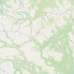
Map view of Fokstugu Landscape Protection Area

Use this park location map to pinpoint Fokstugu Landscape Protection Area in Norway, understand its exact geographic position, and read its mapped placement within the surrounding landscape more clearly.

Pigeon | © OpenStreetMap contributors

Location context for Fokstugu Landscape Protection Area

Innlandet

Visual exploration of Dovrefjell plateau terrain and protected highland habitats

Fokstugu landskapsvernområde Photos and Mountain Landscape Scenery

Visual records capture open mountain terrain, geological formations, and traditional highland pastures across the Dovrefjell plateau. Photographic references help observers study the protected landscape character and connectivity features of Fokstugu landskapsvernområde.

A wide view of the Fokstugu mountain lodge complex, characterized by several traditional buildings set within a rolling, shrub-covered moorland with mountains in the background.

Park atlas

Compare nearby mountain terrain, regional connectivity, and adjacent protected landscapes.

Parks Near Fokstugu Landskapsvernområde and Surrounding Protected Areas

Browsing other protected areas near Fokstugu landskapsvernområde reveals connected mountain terrain and adjacent alpine reserves across the region. Regional park comparison provides a deeper understanding of continuous conservation corridors and high plateau geography.
Watercolor painting showing a mountainous landscape with a waterfall, grassy fields, and wildflowers
National parkInnlandet
About 7.4 km away#1 closest

North

Dovrefjell, Sunndalsfjella National Park: Mapping Norway's Largest Alpine Protected Landscape

Explore its protected boundaries, mountain terrain, and unique ecological significance.

Dovrefjell, Sunndalsfjella National Park is a cornerstone of Norwegian protected areas, offering an expansive alpine wilderness with dramatic mountain scenery. This page details the park's geographic context, mapped landscape features, and its importance as a refuge for unique wildlife like wild reindeer and muskox. Users can investigate the park's protected boundaries and understand its role within the regional geography of Innlandet, contributing to a structured atlas of Scandinavia's natural heritage.

Area
1,693 km²
Established
2002
IUCN
II
Relief
Mountain
Watercolor painting of mountain peaks with green valleys and grassy foreground
National parkInnlandet
About 12 km away#2 closest

South

Rondane National Park: Norway's Premier Alpine Protected Landscape and Historic National Park

Mapped glacial terrain, iconic peaks, and wild reindeer sanctuary.

As Norway's first national park, Rondane offers a profound exploration of a protected alpine environment. Situated in Innlandet county, its 963 square kilometers showcase a landscape sculpted by glaciers, featuring a striking array of ten peaks exceeding 2,000 meters. This page details Rondane National Park's distinct mapped boundaries, dramatic mountain geography, and its ecological significance as a refuge for wild reindeer, making it a cornerstone of Scandinavian natural heritage.

Area
963 km²
Established
1962
IUCN
II
Relief
Mountain
National parkInnlandet
About 13 km away#3 closest

East

Dovre National Park: Mapped Alpine Terrain & Protected Reindeer Habitat in Innlandet

Norway's protected mountain plateau landscape and wildlife corridor.

Dovre National Park is a significant protected area in Innlandet, Norway, characterized by its expansive alpine plateau terrain and role as a vital ecological corridor for wild reindeer. This national park offers users an atlas-level view of its mapped natural boundaries, focusing on the unique subarctic mountain landscape and its conservation importance. Understand Dovre National Park's geographic identity and its contribution to a contiguous network of protected lands.

Area
289 km²
Established
2003
IUCN
II
Relief
Mountain
Watercolor illustration of a mountain range with green hills and a lake in the foreground
National parkNorway
About 55 km away#4 closest

Southwest

Jotunheimen National Park: Norway's Iconic Alpine Protected Landscape and Geographic Core

Explore mapped glacial terrain and alpine geography.

Jotunheimen National Park stands as a monument to Norway's alpine grandeur, protecting over 1,151 square kilometers of spectacular mountainous terrain. This protected area is defined by its dramatic glacial features, including sharp peaks exceeding 1,900 meters, U-shaped valleys, and pristine alpine lakes, making it a significant focus for geographic exploration and mapped landscape study. Delve into the core of Norway's mountain heartland, understanding the mapped boundaries and regional geological context that shape this iconic protected landscape.

Area
1,151 km²
Established
1980
IUCN
II
Relief
Mountain
National parkInnlandet
About 58 km away#5 closest

West

Reinheimen National Park: Norway's Vast Protected Wilderness Landscape and Alpine Geography

Map of protected boundaries and diverse mountain terrain.

Reinheimen National Park is a cornerstone of Norway's protected areas, encompassing a substantial portion of Western Norway's alpine wilderness. This national park protects a dynamic landscape characterized by dramatic western peaks and gentler eastern plateaus, providing critical habitat for wild reindeer and other wildlife. Its extensive mapped boundaries and varied natural terrain offer a rich subject for geographic discovery and atlas exploration, highlighting the ecological significance of well-preserved mountain ecosystems within Innlandet.

Area
1,969 km²
Established
2006
IUCN
II
Relief
Mountain
National parkNorway
About 79 km away#6 closest

Northeast

Forollhogna National Park: Norway's Gently Rolling Alpine Protected Landscape Atlas

Explore unique terrain and vital wild reindeer habitat in Central Norway.

MoriAtlas provides structured geographic context for Forollhogna National Park, Norway's nineteenth national park. This area is best known for its distinctively gentle, rolling alpine terrain, a contrast to other Norwegian mountain ranges, and as a critical habitat for wild reindeer. Discover the park's unique landscape character, its role as a protected area, and the ongoing cultural traditions tied to its mountain pastures, all visualized within a comprehensive atlas framework.

Area
1,062 km²
Established
2001
IUCN
II
Relief
Mountain
National parkVestland
About 101 km away#7 closest

West

Jostedalsbreen National Park: Europe's Premier Glacial Protected Landscape

Mapped terrain and protected area discovery in Vestland, Norway.

Jostedalsbreen National Park represents a unique geographic entity, safeguarding the largest glacier on the European mainland. This national park, situated in Norway's Vestland region, offers profound insights into glacial landscapes and mountain geography. Users can explore the vast ice mass that dominates the terrain, observe the U-shaped valleys carved by its movement, and understand the geological processes shaping this dynamic environment. The park's protected status highlights its importance for understanding glacial science and preserving a critical component of Norway's natural heritage.

Area
1,310 km²
Established
1991
IUCN
II
Relief
Mountain
National parkInnlandet
About 102 km away#8 closest

South

Langsua National Park: Protected Mountain Forests and Inland Wilderness in Innlandet, Norway

Discover mapped boundaries and regional geographic context.

Langsua National Park, a designation expanded in 2011, is a prominent protected area in Norway's Innlandet county. This national park encompasses 537.1 square kilometers of diverse mountainous terrain, characterized by extensive mountain forests and inland wilderness habitats. Its creation consolidates fragmented nature reserves into a significant contiguous protected landscape, offering valuable insight into Norway's conservation strategies and the geographic context of its eastern mountain regions.

Area
537.1 km²
Established
2011
IUCN
II
Relief
Mixed relief

Common questions about visiting, size, designation, and location context for Fokstugu Landscape Protection Area

Fokstugu Landscape Protection Area FAQs for park facts, access, geography, and protected area context

Find quick answers about Fokstugu Landscape Protection Area, including protected-area facts, park geography, trail and visitor context, and how the park fits into its surrounding country and regional landscape.
MoriAtlas Explorer

Continue Your Protected Areas Search Across the Global Atlas

Deepen your exploration by continuing the structured search for national parks and protected areas worldwide. Utilize the comprehensive filtering capabilities to compare different conservation landscapes and refine your understanding of global park geography. Discover more about the distribution and characteristics of protected natural areas.

Global natural geography