
Hills
Park geography
Technical overview of protected landscapes, mountain topography, and regional geography
Folgefonna National Park Geographic Profile: Boundaries, Elevation, and Natural Terrain
This geographic profile details the physical scope of Folgefonna National Park within the Vestland region of Norway. It presents structured data on the 545.2 square kilometer protected area, including peak elevations reaching 1662 meters and specific landforms such as Folgefonni, various mountain peaks, and alpine valleys.
Norway's third-largest glacier park on the Folgefonna peninsula
Folgefonna National Park
Folgefonna National Park is a 545-square-kilometre protected area in Vestland county, Norway, established in 2005. The park occupies the mountainous Folgefonna peninsula, spanning the municipalities of Kvinnherad, Etne, and Ullensvang. Its defining feature is Folgefonna, a massive ice cap comprising three connected glaciers—Nordre Folgefonna, Midtre Folgefonna, and Søndre Folgefonna—which together form the third-largest glacier in Norway. The park encompasses dramatic glacial landscapes, steep valleys, and a transition from valley farms below to barren alpine terrain above the tree line. Queen Sonja formally opened the park in May 2005, marking its establishment as one of Norway's newer national parks.
- Location
- Norway
- Park type
- National park
- Established
- 2005
- Area
- 545.2 km²
- Highest point
- 1,662 m
Location overview
Regional placement and land status within Vestland, Norway
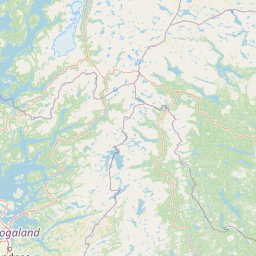
Geographic Location of Folgefonna National Park in Norway
Folgefonna National Park is positioned within the Vestland region of Norway. Administrative records confirm its status as a mainland protected area without transboundary or marine zones.
- Countries
- Norway
- Regions
- Vestland
- Primary location
- Vestland
- Geographic setting
- Inland
Boundary and coordinates
Mapping the 545.2 square kilometer footprint and coordinate span
Folgefonna National Park Boundary Map and Spatial Limits
Interactive spatial geometry traces the conservation perimeter of Folgefonna National Park on the map. Accompanying data outlines the total area of 545.2 square kilometers alongside geographic center and span coordinates.
- Boundary area
- 545.4 km²
- Boundary perimeter
- 192.1 km
- Northernmost point
- 60.2622° N
- Southernmost point
- 59.8537° N
- Easternmost point
- 6.5454° E
- Westernmost point
- 6.0455° E
- Geographic centre
- 60.0249° N, 6.3361° E
- North–south span
- 45.5 km
- East–west span
- 27.8 km
Elevation and terrain
Mountain terrain profiles and recorded natural features
Folgefonna National Park Elevation Summary and Terrain Geography
Recorded elevation facts establish a maximum height of 1662 meters across the mountain relief. Linked feature cards supply names, types, and spatial relationships for glaciers, hills, and rivers.
- Maximum elevation
- 1,662 m
- Highest point
- 1,662 m
Selected named natural features
Hills
Dyrskardheia
588 m
Hills
Øvste Hovden
650 m
Glaciers
Sauabreen
Hills
Selnut
1,216 m
Hills
Nordbakkenuten
Environmental setting
Temperate mountain relief, glacial ice fields, and forest cover distributions
Folgefonna National Park Environmental Classifications and Physical Setting Profile
Recorded landscape features, habitat types, and climate zones combine to frame the physical setting across the protected area. Linked classifications connect recorded environmental categories to related atlas destinations and terrain profiles.
- Relief
- Mountain
- Climate
- Temperate
- Water
- Minor water
- Forest cover
- Partial forest
Landscape features
Mountains · Glacier · Forest · Lakes
Habitat types
Temperate coniferous forest · Alpine meadow · Riverine habitat
Park atlas
Map the broader protected landscape and regional park geography across Vestland county, extending your exploration from Folgefonna National Park.
Explore Related National Parks and Protected Areas Surrounding Folgefonna National Park
Browse a curated selection of national parks and protected areas geographically related to Folgefonna National Park, encompassing diverse conservation landscapes within Norway's Vestland county. This focused collection aids in comparing various park geographies and understanding the distribution of protected alpine, glacial, and fjord environments across the region.
National parkVestland
8.5 km away#1 closest
East

Hardangervidda National Park: Vast Arctic Plateau and European Peneplain Discovery
Explore Norway's largest national park and its unique tundra ecosystem.
Delve into the geography of Hardangervidda National Park, Norway's largest national park, featuring the expansive Arctic plateau and Europe's largest peneplain. This protected landscape offers a unique mapped environment characterized by treeless moorland, numerous lakes, and important wildlife habitats, including significant wild reindeer populations. Understand its position within the Vestland region and its value as a key protected area for geographic exploration and landscape context.
- Area
- 3,422 km²
- Established
- 1981
- IUCN
- II
- Relief
- Highland
National parkNorway
About 74 km away#2 closest
Northeast
Hallingskarvet National Park: Norway's High Mountain Plateau and Protected Wilderness
Mapping glacial terrain, alpine environments, and wild reindeer habitat.
Hallingskarvet National Park offers a unique window into Norway's geological history and alpine ecology. This protected landscape encompasses the striking Hallingskarvet plateau and the Vargebreen glacier, along with deep valleys carved by ancient ice. Users can explore the park's mapped boundaries, understand its regional geographic setting in Scandinavia, and appreciate its conservation value as a habitat for wild reindeer. The park's terrain provides a concrete example of glacial shaping and high-altitude ecosystems within the Nordic context.
- Area
- 450 km²
- Established
- 2006
- IUCN
- II
- Relief
- Mountain
National parkVestland
125 km away#3 closest
North
Jostedalsbreen National Park: Europe's Premier Glacial Protected Landscape
Mapped terrain and protected area discovery in Vestland, Norway.
Jostedalsbreen National Park represents a unique geographic entity, safeguarding the largest glacier on the European mainland. This national park, situated in Norway's Vestland region, offers profound insights into glacial landscapes and mountain geography. Users can explore the vast ice mass that dominates the terrain, observe the U-shaped valleys carved by its movement, and understand the geological processes shaping this dynamic environment. The park's protected status highlights its importance for understanding glacial science and preserving a critical component of Norway's natural heritage.
- Area
- 1,310 km²
- Established
- 1991
- IUCN
- II
- Relief
- Mountain
National parkNorway
144 km away#4 closest
Northeast
Jotunheimen National Park: Norway's Iconic Alpine Protected Landscape and Geographic Core
Explore mapped glacial terrain and alpine geography.
Jotunheimen National Park stands as a monument to Norway's alpine grandeur, protecting over 1,151 square kilometers of spectacular mountainous terrain. This protected area is defined by its dramatic glacial features, including sharp peaks exceeding 1,900 meters, U-shaped valleys, and pristine alpine lakes, making it a significant focus for geographic exploration and mapped landscape study. Delve into the core of Norway's mountain heartland, understanding the mapped boundaries and regional geological context that shape this iconic protected landscape.
- Area
- 1,151 km²
- Established
- 1980
- IUCN
- II
- Relief
- Mountain
National parkInnlandet
About 165 km away#5 closest
North
Breheimen National Park: Protected Glacial Landscapes and Mountain Terrain in Innlandet
Norway's prominent national park featuring active glaciers and alpine geography.
Breheimen National Park represents a significant protected landscape within Norway's Innlandet region, dedicated to conserving its unique glacial formations and dramatic alpine terrain. The park's vast area encompasses active glaciers, soaring peaks, and a notable diversity of natural environments, from lush valleys to barren plateaus. MoriAtlas facilitates a detailed exploration of Breheimen National Park, highlighting its mapped protected boundaries and its integral role in the regional geography and protected areas atlas.
- Area
- 1,671 km²
- Established
- 2009
- IUCN
- II
- Relief
- Mountain
Nature reserveRingerike
About 187 km away#6 closest
East
Vikerfjell naturreservat: Geographic Atlas of Protected Forests in Ringerike, Norway
Mapped terrain of high-lying plateaus, ancient coniferous forests, and wetland mosaic.
Vikerfjell naturreservat serves as a vital protected area for old-growth coniferous forests and vulnerable lichen species. This atlas provides a detailed view of its mountain plateaus, forested slopes, and the expansive mire systems that characterize this key southern Norwegian conservation landscape within the Ringerike municipality.
- Area
- 80.335 km²
- Established
- 2016
- Relief
- Mountain
- Climate
- Boreal
National parkInnlandet
About 193 km away#7 closest
Northeast
Langsua National Park: Protected Mountain Forests and Inland Wilderness in Innlandet, Norway
Discover mapped boundaries and regional geographic context.
Langsua National Park, a designation expanded in 2011, is a prominent protected area in Norway's Innlandet county. This national park encompasses 537.1 square kilometers of diverse mountainous terrain, characterized by extensive mountain forests and inland wilderness habitats. Its creation consolidates fragmented nature reserves into a significant contiguous protected landscape, offering valuable insight into Norway's conservation strategies and the geographic context of its eastern mountain regions.
- Area
- 537.1 km²
- Established
- 2011
- IUCN
- II
- Relief
- Mixed relief
National parkTelemark
About 209 km away#8 closest
Southeast
Jomfruland National Park: Coastal Archipelago and Skagerrak Marine Atlas
Norway's unique marine-focused national park landscape.
Jomfruland National Park is a significant protected landscape in Telemark, Norway, renowned for its coastal island geography and a landscape predominantly composed of marine waters. Covering 117 square kilometers, this national park emphasizes the conservation of both terrestrial island habitats and the surrounding Skagerrak coastal ecosystem. Explore the park's mapped boundaries and discover its regional geographic context, offering a unique perspective on Norway's protected areas and maritime natural heritage through MoriAtlas.
- Area
- 117 km²
- Established
- 2016
- IUCN
- II
- Scope
- Mixed
MoriAtlas Explorer
Continue Exploring Folgefonna National Park's Glacier Geography and Mapped Terrain
Deepen your understanding of Folgefonna National Park by exploring its detailed geographic context and protected landscape features. MoriAtlas helps you navigate the park's significant mapped boundaries and its role within Vestland's broader regional geography. Continue your atlas discovery to appreciate the scale and character of this prominent Norwegian protected area.
Browse next
Global natural geography
Explore related park routes
Explore MoriAtlas Global ParksBrowse All MoriAtlas ParksGlobal Park Map DiscoveryMoriAtlas: Browse All CountriesBrowse All MoriAtlas ContinentsNational Park Environment AtlasGrand Canyon National Park AtlasYellowstone National Park AtlasYosemite National Park Atlas and GeographySerengeti National Park AtlasGalápagos National Park Protected LandscapeBanff National Park Geography and AtlasKruger National Park Atlas EntryUluṟu-Kata Tjuṯa National Park AtlasExplore Uluru-Kata Tjuta National Park GeographyPlitvice Lakes National Park AtlasFiordland National Park Protected LandscapeGreat Smoky Mountains National Park AtlasAfghanistan National Parks and Protected AreasAlbania National Parks and Protected AreasAlgeria National Parks and Protected AreasAmerican Samoa National Parks and Protected AreasAndorra National Parks and Protected AreasAngola National Parks and Protected AreasAntarctica National Parks and Protected AreasAntigua and Barbuda Park List