

Mori Atlas logo
National parkGyeongju National Park

Trace the mapped boundaries of this national park and understand its regional atlas placement.

Gyeongju National Park: Protected Landscape and Geographic Context in North Gyeongsang Province

Gyeongju National Park represents a significant protected landscape within the North Gyeongsang Province of South Korea. As a designated national park, its protected area status is crucial for understanding regional geography and natural landscape context. This page provides a foundational atlas view, detailing the park's geographic scope and mapped boundaries to support structured discovery for those interested in protected lands and their placement within broader cartographic and regional frameworks.

Cultural Heritage ParkSilla Dynasty Archaeological SitesUNESCO World Heritage SiteHistorical National ParkBuddhist Temple SitesKorean Ancient Capital

Gyeongju National Park

National park

Park overview

Structured park overview, official facts, and landscape profile for Gyeongju National Park

Gyeongju National Park park facts, protected area profile, and essential visitor context
Review the core facts for Gyeongju National Park, including designation, size, terrain, visitor scale, habitats, and operating context in one park-focused overview.

About Gyeongju National Park

Gyeongju National Park occupies a unique position within South Korea's protected area system as the nation's only park created specifically to preserve historical and archaeological heritage rather than natural ecosystems. The park surrounds and incorporates the ancient city of Gyeongju, which served as the capital of the Silla Kingdom for nearly a thousand years and stands as one of the world's longest continuously inhabited cities. The park's eight non-contiguous sections contain different clusters of cultural sites, creating a network of protected zones that collectively preserve the physical fabric of ancient Korean civilization. Visitors to the park can explore ancient temple complexes such as Bulguksa, founded in 528 CE and containing some of Korea's finest examples of Buddhist architectural heritage. The nearby Seokguram Grotto houses a remarkable ninth-century Buddha statue considered a masterpiece of East Asian Buddhist art. Throughout the park's mountainous sections, numerous rock-cut Buddha figures and carved inscriptions bear witness to the deep religious traditions that shaped Silla culture. The park's landscape itself is significant, featuring gentle forested mountains, traditional Korean garden ponds, and the natural settings that Silla architects integrated with their built structures. The management approach for this park differs from typical national parks, as the Korea National Park Service must balance visitor access to cultural sites with preservation requirements for ancient structures that represent irreplaceable elements of Korean heritage.

Quick facts and research context for Gyeongju National Park

Gyeongju National Park covers approximately 137 square kilometers of mountainous terrain surrounding the ancient Silla capital of Gyeongju. The park is administered by the Korea National Park Service and holds IUCN Category II protected area status. Its eight sections include Gumisan and Danseoksan to the west, Hwarang, Seoak, Sogeumgang, and Namsan in the central area, Tohamsan to the east, and Daebon along the coast of the Sea of Japan. The park protects hundreds of individual cultural heritage sites including ancient temples such as Bulguksa, numerous royal tombs from the Silla Kingdom, carved Buddhist images, and reconstructed pavilion structures. As the only historical national park in South Korea's twenty-two park system, it represents a distinctive approach to protected area management that prioritizes cultural landscape preservation alongside natural scenery.

Park context

Deeper park guide and search-rich context for Gyeongju National Park

Gyeongju National Park history, landscape, wildlife, and travel context
Explore Gyeongju National Park through its history, landscape character, ecosystems, wildlife, conservation priorities, cultural context, and seasonal travel timing in a structured park guide built for atlas discovery and search intent.

Why Gyeongju National Park stands out

Gyeongju National Park is best known for its extraordinary concentration of Silla dynasty archaeological sites, representing one of the most significant repositories of ancient Korean cultural heritage in existence. The park contains numerous UNESCO World Heritage-designated sites including the Bulguksa temple complex, the Seokguram Grotto with its masterful Buddhist sculpture, and the impressive royal tombs of the Gyeongju Historic Areas. The park is renowned for preserving the physical remains of the Silla Kingdom capital that flourished from roughly 57 BCE to 935 CE, including palace foundations, government building sites, fortress walls, and hundreds of carved stone Buddha figures. Anapji pond, with its reconstructed pavilion, has become an iconic symbol of the park and appears in virtually all representations of the site. The mountain sections contain ancient Buddhist carvings and shamanistic rock formations that reveal the deep spiritual history of the region.

Gyeongju National Park history and protected-area timeline

Gyeongju National Park was established on December 31, 1968, becoming South Korea's second national park to be designated after the creation of the national park system. The establishment reflected growing recognition that the extraordinary archaeological heritage of the Gyeongju region required formal protected status beyond simple cultural heritage preservation. The selection of Gyeongju as a national park represented a novel concept in Korean conservation, as it focused on protecting a cultural landscape rather than a wilderness area or natural ecosystem. Prior to national park designation, many of the Silla-era sites had suffered from neglect, looting, and encroaching development as Gyeongju modernized. The park's creation provided the Korea National Park Service with authority to manage large areas around individual heritage sites, creating coherent protected zones that encompass both the monuments and their natural settings. Over the decades since establishment, the park has been expanded and refined to include additional sites, with the eight-section structure developing through subsequent management decisions. The park's historical focus was formally recognized internationally when the Gyeongju Historic Areas were inscribed as a UNESCO World Heritage Site in 2000, bringing additional international attention to the park's significance and reinforcing the importance of integrated cultural-natural landscape management.

Gyeongju National Park landscape and geographic character

The landscape of Gyeongju National Park consists of a series of low mountains and forested hills that surround the Gyeongju urban area, creating a scenic backdrop that has shaped Korean aesthetic sensibilities for centuries. The park's terrain is characterized by granite peaks and ridges that rise gently from the surrounding plain, with most summits reaching elevations between 200 and 700 meters. The mountainous sections, particularly around Namsan, Tohamsan, and the western Gumisan and Danseoksan areas, contain dense forests of pine, oak, and deciduous trees that change dramatically with the seasons. Several streams and small rivers descend through the park's valleys, feeding traditional pond systems that were integral to Silla palace design. The coastal Daebon section provides access to the Sea of Japan shoreline, adding marine scenery to the park's diverse landscapes. The geological character of the region features prominent granite outcrops and boulder fields that Silla artisans incorporated into their Buddhist carvings, creating a harmonious integration of natural rock formations with sculpted images. The landscape is not dramatic in the sense of towering peaks or dramatic waterfalls, but rather possesses a subtle beauty characterized by rolling forested hills, peaceful valleys, and the sense of ancient presence that permeates the historic sites.

Gyeongju National Park ecosystems, habitats, and plant life

The natural environment of Gyeongju National Park, while secondary to its cultural mission, nevertheless provides meaningful habitat and ecosystem services within the managed landscape. The park's forests represent typical Korean temperate forest communities including mixed deciduous woodlands dominated by oak and maple species, with significant pine coverage on drier ridges and slopes. The forest understory contains diverse shrub layers and herbaceous plants, creating layered vegetation that supports various wildlife species. The park's multiple sections, connected by surrounding undeveloped land, create wildlife corridors that allow animal movement through the Gyeongju metropolitan area. The mountain sections, particularly the larger Namsan and Tohamsan areas, provide more extensive natural habitat than the heavily visited temple and tomb sites. Water features including streams, small reservoirs, and the coastal areas of the Daebon section add habitat diversity. The Korea National Park Service maintains the natural vegetation as part of the overall park management, conducting forest health monitoring and invasive species management. While the park is not primarily designated for biodiversity conservation, the natural landscapes contribute to visitor experience and support ecological functions within the broader regional environment.

Gyeongju National Park wildlife and species highlights

Wildlife in Gyeongju National Park consists of typical Korean forest-dwelling species, with the park's location in the southeastern part of the Korean Peninsula providing habitat for both southern and northern species ranges. Mammal species present in the park likely include common species such as raccoon dogs, Korean hares, and various squirrel species, with larger mammals like Korean elk and wild boars occasionally present in the more remote mountain sections. The diverse forest structure supports bird populations including various thrushes, woodpeckers, and corvids, with seasonal migrations bringing additional species through the area in spring and autumn. The park's streams and ponds provide habitat for water birds and support amphibian populations. While the park is not specifically known for exceptional wildlife viewing opportunities like some of South Korea's mountain parks, the natural areas do support ecological communities that visitors may encounter. The emphasis on cultural heritage means that wildlife information is less prominent in park materials compared to natural parks, but the forested sections do provide meaningful habitat within the regional landscape. The Korea National Park Service maintains the natural areas in conditions that support wildlife, and the park's multiple sections create habitat connectivity through the metropolitan region.

Gyeongju National Park conservation status and protection priorities

Gyeongju National Park represents a distinctive approach to conservation that prioritizes cultural landscape preservation within a national park framework. The park's conservation focus centers on protecting the physical integrity of Silla-era structures including temples, tombs, carved images, and other archaeological features from damage, deterioration, and inappropriate development. This requires ongoing maintenance, restoration work, and management of visitor access to prevent wear on ancient structures. The park's designation as a UNESCO World Heritage site in 2000 as part of the Gyeongju Historic Areas brought additional international conservation frameworks and resources to bear on site preservation. Conservation challenges include managing the large numbers of visitors who come to experience the cultural heritage while protecting sensitive ancient structures, balancing development pressures within the park boundaries, and addressing the effects of weather and time on outdoor cultural monuments. The Korea National Park Service employs specialized conservation expertise for historical structures, drawing on both traditional Korean building techniques and modern conservation science. The park's multiple-section structure creates conservation complexity, requiring coordinated management across different areas with varying levels of visitor use and environmental conditions.

Gyeongju National Park cultural meaning and human context

Gyeongju National Park sits at the heart of what was the Silla Kingdom's capital, one of the longest-lived dynastic capitals in world history, continuously inhabited for nearly a millennium. The region served as the political, religious, and cultural center of the Silla state from roughly 57 BCE until the kingdom's eventual absorption into the Goryeo dynasty in 935 CE. The park preserves the physical evidence of this remarkable civilization, including Buddhist temples that served as both religious centers and institutions of learning, royal tombs that housed the remains of Silla monarchs, and countless carved images that reflect the deep Buddhist faith that permeated Silla society. Gyeongju was known historically as 'the city of gold' due to the abundant golden artifacts buried in royal tombs, and the park contains numerous sites where such discoveries were made. The landscape itself carries deep spiritual significance, with mountains considered sacred and sites chosen according to traditional Korean geomancy and Buddhist cosmological principles. The cultural context extends to traditional Korean garden design, evident in ponds like Anapji that reflect classical Korean aesthetic ideals. Modern Gyeongju continues to draw upon its ancient heritage as a cultural tourism destination, with the national park serving as the primary framework for experiencing this extraordinary historical landscape.

Top sights and standout views in Gyeongju National Park

Gyeongju National Park offers an unparalleled journey through Korean civilization, with highlights including the Bulguksa temple complex, one of Korea's oldest and most significant Buddhist temples, with its characteristic stone archways and wooden hall structures. The Seokguram Grotto contains what many consider the finest Buddhist sculpture in Korean history, a monumental ninth-century Buddha seated within an artificial cave carved into the mountainside. The royal tomb area, particularly the large mound tombs of ancient Silla kings, provides tangible evidence of burial practices and royal power in ancient Korea. Namsan mountain contains hundreds of carved Buddhist images scattered throughout its forests, representing one of the densest concentrations of such carvings in East Asia. The Anapji pond area offers a peaceful recreation of Silla garden design, with its reconstructed pavilion and island setting. The park's eight distinct sections each contain different thematic groupings of sites, from the coastal Daebon area to the mountain-top carvings of the interior sections. The park's designation as South Korea's only historical national park makes it essential for understanding Korean cultural heritage and the development of Korean civilization from ancient through medieval periods.

Best time to visit Gyeongju National Park

The optimal seasons for visiting Gyeongju National Park are spring and autumn, when mild temperatures and colorful seasonal scenery enhance the experience of exploring the historical sites. Spring brings pleasant weather and the flowering of cherry blossoms and other trees, while autumn offers comfortable temperatures and the striking colors of changing deciduous foliage against ancient stone structures. Summer months can be hot and humid, though the forest sections provide some shade, while winter offers a quieter experience with fewer visitors though some facilities may have reduced services. The park's outdoor sites are generally accessible year-round, though winter conditions may make some mountain trails more challenging. The cultural heritage sites can be visited during any season, but the experience of walking through temple grounds or exploring tomb areas is notably enhanced by pleasant weather. Morning visits tend to be less crowded than afternoon periods, particularly at major sites like Bulguksa and Seokguram. The park's proximity to the Gyeongju city center means that accommodation and services are readily available regardless of when visitors choose to explore the park's various sections.

Park location guide

Geography guide, regional context, and park location map for Gyeongju National Park

Gyeongju National Park park geography, regions, and map view in South Korea
Understand where Gyeongju National Park sits in South Korea through a broader geographic reading of the surrounding landscape, nearby location context, and its mapped position within the national park landscape.

How Gyeongju National Park fits into South Korea

South Korea is a presidential republic on the Korean Peninsula in East Asia. It has a population of about 51 million and Seoul as its capital and largest city. The country is known for its rapid economic development, high technology industry, and cultural exports.

Wider geography shaping Gyeongju National Park in South Korea

South Korea occupies the southern half of the Korean Peninsula in East Asia. It borders North Korea along the Demilitarized Zone to the north, the Yellow Sea to the west, and the Sea of Japan to the east. The terrain is predominantly mountainous with coastal plains along the southern and eastern shores.

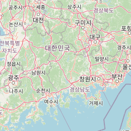
Map view of Gyeongju National Park

Use this park location map to pinpoint Gyeongju National Park in South Korea, understand its exact geographic position, and read its mapped placement within the surrounding landscape more clearly.

Pigeon | © OpenStreetMap contributors

Location context for Gyeongju National Park

North Gyeongsang Province
Park atlas

Trace the regional geography and compare other protected landscapes surrounding Gyeongju National Park

Discover National Parks and Protected Areas Near Gyeongju National Park
After exploring Gyeongju National Park's unique cultural heritage, continue your discovery by examining other national parks and protected areas in the surrounding South Korean region. Compare diverse protected landscapes, their geographic contexts, and conservation priorities to broaden your atlas knowledge.
National parkSouth Korea

Juwangsan National Park: Protected Mountain Landscape and Regional Geography in South Korea

Mapped terrain, park boundaries, and natural landscapes.

Juwangsan National Park is a protected natural area situated within South Korea's Taebaek mountain range, renowned for its steep valleys, waterfalls, and dense forests. This park offers a rich landscape context, showcasing dramatic ridgelines and providing a significant example of South Korea's protected mountain terrain. Discover its geographic placement, mapped protected boundaries, and the unique natural and cultural elements that define this national park.

Area
107.42 km²
Established
1976
IUCN
II
Relief
Mountain
National parkSouth Gyeongsang Province

Gayasan National Park: National Park Identity and Mapped Geographic Context in South Korea

Discover Protected Landscape and Regional Terrain

Gayasan National Park presents a distinct protected-area entity within South Gyeongsang Province, serving as a crucial point for atlas-driven geographic exploration. As a designated national park in South Korea, it offers insights into its specific mapped boundaries and the surrounding natural terrain. Understanding this park's role within the regional geography provides a foundational element for comprehending broader landscape patterns and protected land distribution across the country.

Area
167.6 km²
Established
1972
IUCN
II
Relief
Mountain
National parkJeollabuk-do

Deogyusan National Park: National Park Identity and Geographic Mapping

Explore its protected land boundaries and regional landscape context.

Examine Deogyusan National Park, a designated national park situated in the Jeollabuk-do region of South Korea. This entry provides critical geographic context, focusing on the park's mapped boundaries and its role as a protected landscape. Users can gain a structured understanding of its natural terrain and regional significance, contributing to a broader atlas of protected areas.

Area
231.65 km²
Established
1975
IUCN
V
Visitors
1M annual
National parkChungcheongbuk-do

Sobaeksan National Park: A Protected Landscape within Chungcheongbuk-do

Explore its park boundaries and regional geography.

Sobaeksan National Park represents a crucial protected area within the mountainous terrain of Chungcheongbuk-do, South Korea. As a designated national park, it offers a valuable point of reference for understanding regional geographic distribution and landscape context across the Korean Peninsula. This park's identity as a protected natural landscape contributes significantly to the atlas-based exploration of conservation areas and their environmental settings.

Area
322.38 km²
Established
1987
IUCN
II
Relief
Mountain
National parkSouth Korea

Songnisan National Park: Mapped Protected Landscape and Geographic Context in South Korea

Discover South Korea's Songnisan National Park and its protected terrain.

Delve into the protected landscape of Songnisan National Park, a key national park entity in South Korea. This atlas-focused view highlights its mapped geographic boundaries and natural terrain, providing essential context for understanding conservation areas. Explore Songnisan National Park as a distinct protected region contributing to the country's diverse geography and mapped natural heritage.

Area
274.541 km²
Established
1970
IUCN
II
Relief
Mountain
Watercolor illustration of green hills, a body of water, and mountain peaks under a soft sky
National parkGyeongsangbuk-do

Woraksan National Park: A Key National Park in Gyeongsangbuk-do's Regional Geography

Discover its mapped mountain terrain and protected landscape identity.

Woraksan National Park offers a detailed view of protected mountain landscapes within South Korea's Gyeongsangbuk-do region. The park is characterized by its prominent Mount Worak, steep ridgelines, and dense forested terrain, contributing significantly to the nation's network of protected areas. Users can explore the geographic context, mapped boundaries, and ecological significance of this vital national park, understanding its place in the broader regional atlas and natural landscape context.

Area
287.78 km²
Established
1984
IUCN
II
Relief
Mountain
National parkSouth Korea

Jirisan National Park: South Korea's Premier Protected Landscape and Map Resource

Explore the mapped terrain and protected area geography.

Jirisan National Park is a key protected area within South Korea, serving as a vital component of the nation's natural landscape. This atlas-focused content provides detailed geographic information, highlighting the park's mapped boundaries and its role within the regional context of the Korean Peninsula. Understand the distinct characteristics of this protected national park for comprehensive geographic discovery.

Area
471.75 km²
Established
1967
IUCN
II
Visitors
1.5M annual
National parkSouth Korea

Hallyeohaesang National Park: South Korea National Park Geographic Atlas Entry

Explore mapped protected area boundaries and natural terrain.

As a designated national park in South Korea, Hallyeohaesang National Park offers a distinct geographic profile crucial for atlas exploration. This entry focuses on its protected landscape features, mapped territorial extent, and regional context within the Republic of Korea. Understand the park's specific geographical markers and its significance as a mapped protected area.

Area
545.63 km²
Established
1968
IUCN
II
Access
Access unknown

Common questions about visiting, size, designation, and location context for Gyeongju National Park

Gyeongju National Park FAQs for park facts, access, geography, and protected area context
Find quick answers about Gyeongju National Park, including protected-area facts, park geography, trail and visitor context, and how the park fits into its surrounding country and regional landscape.
MoriAtlas Explorer

Continue Your Protected Areas Search Across the Global Atlas

Deepen your exploration by continuing the structured search for national parks and protected areas worldwide. Utilize the comprehensive filtering capabilities to compare different conservation landscapes and refine your understanding of global park geography. Discover more about the distribution and characteristics of protected natural areas.

Global natural geography