

Mori Atlas logo
National parkGyeryongsan National Park

Mapping the geographic boundaries and regional context of Gyeryongsan National Park.

Gyeryongsan National Park: South Korea's Protected Landscape in Chungcheongnam-do

Gyeryongsan National Park stands as a key protected area within the geographic landscape of Chungcheongnam-do, South Korea. This atlas-focused entry provides essential context for understanding its mapped boundaries and role as a national park. Explore the detailed geography and discover the natural terrain that defines this significant protected region.

Granite MountainsSouth Korean National ParksMountain HikingBiodiversity HotspotsHistoric TemplesEndangered Species

Gyeryongsan National Park

National park

Park overview

Structured park overview, official facts, and landscape profile for Gyeryongsan National Park

Gyeryongsan National Park park facts, protected area profile, and essential visitor context
Review the core facts for Gyeryongsan National Park, including designation, size, terrain, visitor scale, habitats, and operating context in one park-focused overview.

About Gyeryongsan National Park

Gyeryongsan National Park represents one of South Korea's most significant protected natural areas, established in 1968 as the second national park in the country. The park is situated in Chungcheongnam-do province, with its main entrance accessible from the nearby city of Daejeon, one of South Korea's major metropolitan areas. The centerpiece of the park is Gyeryongsan itself, a 845-meter mountain composed primarily of granite that creates a distinctive silhouette against the Korean landscape. The mountain's name, which translates as Rooster Dragon Mountain, references the shape of its twin peaks that resemble both a rooster's comb and the curved spine of a dragon. The park's terrain is characterized by steep valleys, rocky cliffs, and Dense Forest that covers much of the slopes. Visitors to the park can explore a network of hiking trails that lead to scenic viewpoints, rock formations, and cultural sites. The park's proximity to Daejeon makes it an important recreational resource for urban residents seeking natural escapes, while its biodiversity and geological features make it a destination of interest for researchers and nature enthusiasts.

Quick facts and research context for Gyeryongsan National Park

Gyeryongsan National Park is located in Chungcheongnam-do province, South Korea, near the city of Daejeon. The park was established on 31 December 1968 as the second national park in South Korea, following the designation of the first Korean national park in 1967. The protected area covers 64.71 square kilometers around the 845-meter Gyeryongsan mountain. The Korea National Park Service manages the park, which supports remarkable biodiversity including eleven endangered animal species such as otter, marten, common buzzard, and black woodpecker. The mountain's distinctive granite formations create a dramatic landscape of cliffs, rock formations, and forested slopes.

Park context

Deeper park guide and search-rich context for Gyeryongsan National Park

Gyeryongsan National Park history, landscape, wildlife, and travel context
Explore Gyeryongsan National Park through its history, landscape character, ecosystems, wildlife, conservation priorities, cultural context, and seasonal travel timing in a structured park guide built for atlas discovery and search intent.

Why Gyeryongsan National Park stands out

Gyeryongsan National Park is best known for its distinctive granite mountain landscape, characterized by sharp peaks, dramatic cliffs, and unusual rock formations that give the mountain its name meaning Rooster Dragon Mountain. The park is particularly famous for its Seoktap rock formation, a natural pillar that stands as an iconic landmark within the protected area. As South Korea's second national park, it holds historical significance in the nation's conservation movement. The park is also recognized for its rich biodiversity, particularly the presence of eleven endangered species including otter, marten, common buzzard, and black woodpecker. Gapsa Temple, a historic Buddhist temple nestled in the mountainside, adds cultural significance to the natural landscape.

Gyeryongsan National Park history and protected-area timeline

Gyeryongsan National Park was established on 31 December 1968, making it the second national park to be designated in South Korea following the creation of the first national park in 1967. This early establishment places the park among the pioneering protected areas in South Korea's modern conservation history, reflecting the country's commitment to preserving its natural heritage during a period of rapid economic development. The designation came at a time when South Korea was beginning to recognize the importance of environmental protection and the value of natural landscapes for both ecological and cultural reasons. The Korea National Park Service was established to manage the protected areas, and Gyeryongsan has been managed under this national system since its designation. The park's establishment also helped preserve the cultural heritage sites within its boundaries, including the historic Gapsa Temple, which predates the modern conservation framework.

Gyeryongsan National Park landscape and geographic character

The landscape of Gyeryongsan National Park is defined by its dramatic granite terrain. The mountain rises abruptly from the surrounding landscape, its steep slopes and rocky outcrops creating a rugged and visually striking environment. The granite formations produce distinctive features including the Seoktap, a towering rock pillar that has become one of the park's most recognizable landmarks. The mountain's twin peaks create a unique silhouette that inspired its Rooster Dragon name, with one peak resembling a rooster's comb and the other suggesting a dragon's curved spine. Deep valleys cut through the mountain, providing habitat for streams and adding to the topographic diversity. Forest coverage dominates the lower and mid elevations, while rock outcrops and cliff faces characterize the higher terrain. The combination of vertical granite cliffs, rolling forested slopes, and seasonal changes in vegetation creates a landscape of considerable scenic variety.

Gyeryongsan National Park ecosystems, habitats, and plant life

The ecological character of Gyeryongsan National Park reflects the biodiversity typical of South Korea's mountainous forest ecosystems. The park supports approximately 1,121 plant species, 1,867 insect species, and 645 animal species, creating a rich ecological community within its 65 square kilometer boundary. The forest types present in the park include both deciduous and mixed forest communities, with various tree species adapted to the mountainous environment. The park's streams and riparian areas support aquatic ecosystems and provide water sources for the diverse wildlife. The varied topography, ranging from valley floors to mountain ridges, creates multiple habitat zones that support different ecological communities. This diversity of habitats contributes to the park's significance as a biodiversity reservoir in a region where development has altered much of the natural landscape.

Gyeryongsan National Park wildlife and species highlights

The wildlife community in Gyeryongsan National Park includes 645 animal species representing a variety of taxonomic groups. Of particular conservation significance are the eleven endangered species that have been recorded within the park, including the otter, a semi-aquatic mammal that inhabits the park's streams and waterways. The marten, a small carnivorous mammal, occupies the forested areas of the park. Bird species represented in the park include the common buzzard and the black woodpecker, both of which are species of conservation concern. The presence of these endangered species highlights the park's importance as a refuge for wildlife in a region where natural habitats have been reduced by agricultural and urban development. The insect community is particularly diverse, with 1,867 species recorded, reflecting the variety of habitats and plant communities present within the protected area.

Gyeryongsan National Park conservation status and protection priorities

Gyeryongsan National Park holds significant conservation importance within South Korea's protected area network. As the country's second national park, established in 1968, it represents an early commitment to systematic nature conservation in South Korea. The park protects important biodiversity, including eleven endangered animal species that rely on the protected habitat for their survival. The protected status helps preserve the granite mountain landscape and its associated ecosystems against development pressures that have affected much of South Korea's natural terrain. The forest communities within the park function as watershed protection areas, helping to maintain water quality in the streams that flow from the mountain. The Korea National Park Service manages the park according to national conservation standards, implementing visitor management, habitat protection, and environmental monitoring programs. The presence of cultural heritage sites within the park, including Gapsa Temple, adds a cultural dimension to the conservation value, as these areas benefit from the protected status that limits development.

Gyeryongsan National Park cultural meaning and human context

Gyeryongsan National Park contains significant cultural heritage elements, most notably the historic Gapsa Temple, which is located within the park boundaries. This Buddhist temple represents centuries of religious and cultural tradition in Korea, with its architecture and setting reflecting the traditional relationship between Korean Buddhism and natural mountain landscapes. The mountain itself holds cultural significance in Korean tradition, with the distinctive peaks inspiring folklore and traditional beliefs that contributed to the naming of the landscape. The combination of natural and cultural elements within the park reflects the Korean concept of sacred mountains, where spiritual, aesthetic, and natural values intersect. Visitors to the park can experience both the natural landscape and the cultural heritage that has been preserved alongside the ecological values.

Top sights and standout views in Gyeryongsan National Park

Gyeryongsan National Park offers visitors distinctive experiences centered on its dramatic granite landscape and cultural heritage. The Seoktap rock formation stands as the park's most iconic natural landmark, a towering granite pillar that draws visitors seeking to experience the mountain's unique geology. Hiking trails provide access to various points of interest, including scenic viewpoints that offer panoramic views of the surrounding landscape and the distinctive twin peaks of Gyeryongsan. Gapsa Temple provides a cultural complement to the natural landscape, allowing visitors to experience traditional Korean Buddhist architecture in a mountain setting. The park's biodiversity, including the eleven endangered species, adds ecological interest for visitors with nature observation interests. The park's accessibility from Daejeon makes it a popular destination for both day visitors and those seeking longer hiking experiences.

Best time to visit Gyeryongsan National Park

Gyeryongsan National Park can be visited throughout the year, with each season offering different experiences of the landscape. Spring brings new vegetation and mild temperatures, making it a popular time for hiking as the forest canopy develops. Summer offers full forest coverage but higher temperatures and increased visitor numbers during vacation periods. Autumn provides particularly striking scenery as the deciduous trees change color, creating a colorful landscape that attracts photographers and visitors seeking fall foliage. Winter reveals the granite rock formations through bare trees, offering a different perspective on the mountain's geology while fewer visitors are present. The best time to visit depends on individual preferences, with spring and autumn generally offering comfortable temperatures and scenic variety, while winter provides a quieter experience with the stark beauty of the granite peaks visible through winter vegetation.

Park location guide

Geography guide, regional context, and park location map for Gyeryongsan National Park

Gyeryongsan National Park park geography, regions, and map view in South Korea
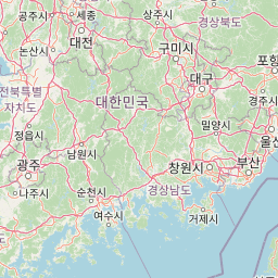
Understand where Gyeryongsan National Park sits in South Korea through a broader geographic reading of the surrounding landscape, nearby location context, and its mapped position within the national park landscape.

How Gyeryongsan National Park fits into South Korea

South Korea is a presidential republic on the Korean Peninsula in East Asia. It has a population of about 51 million and Seoul as its capital and largest city. The country is known for its rapid economic development, high technology industry, and cultural exports.

Wider geography shaping Gyeryongsan National Park in South Korea

South Korea occupies the southern half of the Korean Peninsula in East Asia. It borders North Korea along the Demilitarized Zone to the north, the Yellow Sea to the west, and the Sea of Japan to the east. The terrain is predominantly mountainous with coastal plains along the southern and eastern shores.

Map view of Gyeryongsan National Park

Use this park location map to pinpoint Gyeryongsan National Park in South Korea, understand its exact geographic position, and read its mapped placement within the surrounding landscape more clearly.

Pigeon | © OpenStreetMap contributors

Location context for Gyeryongsan National Park

Chungcheongnam-do
Park atlas

Explore adjacent protected landscapes and compare the geographic spread of national parks across South Korea.

Discover Other National Parks and Protected Areas near Gyeryongsan National Park
After exploring Gyeryongsan National Park, browse other protected areas, tracing their locations and unique landscape features within the surrounding region. Compare Gyeryongsan's distinct granite mountains and biodiversity with nearby national parks to understand broader conservation geography and discover new exploration destinations.
National parkSouth Korea

Songnisan National Park: Mapped Protected Landscape and Geographic Context in South Korea

Discover South Korea's Songnisan National Park and its protected terrain.

Delve into the protected landscape of Songnisan National Park, a key national park entity in South Korea. This atlas-focused view highlights its mapped geographic boundaries and natural terrain, providing essential context for understanding conservation areas. Explore Songnisan National Park as a distinct protected region contributing to the country's diverse geography and mapped natural heritage.

Area
274.541 km²
Established
1970
IUCN
II
Relief
Mountain
National parkJeollabuk-do

Deogyusan National Park: National Park Identity and Geographic Mapping

Explore its protected land boundaries and regional landscape context.

Examine Deogyusan National Park, a designated national park situated in the Jeollabuk-do region of South Korea. This entry provides critical geographic context, focusing on the park's mapped boundaries and its role as a protected landscape. Users can gain a structured understanding of its natural terrain and regional significance, contributing to a broader atlas of protected areas.

Area
231.65 km²
Established
1975
IUCN
V
Visitors
1M annual
National parkJeollabuk-do

Byeonsan-bando National Park: Protected Landscape and Geographic Context in Jeollabuk-do

Explore mapped terrain and regional park geography.

This detail page provides an in-depth look at Byeonsan-bando National Park, a protected area located in South Korea's Jeollabuk-do region. Users can discover the park's specific geographic identity, understand its mapped boundaries, and explore its role within the broader regional landscape. The content is structured for atlas exploration, offering detailed insights into the park's natural terrain and its significance as a national park.

Area
154.71 km²
Established
1988
IUCN
II
Relief
Mixed relief
National parkSouth Gyeongsang Province

Gayasan National Park: National Park Identity and Mapped Geographic Context in South Korea

Discover Protected Landscape and Regional Terrain

Gayasan National Park presents a distinct protected-area entity within South Gyeongsang Province, serving as a crucial point for atlas-driven geographic exploration. As a designated national park in South Korea, it offers insights into its specific mapped boundaries and the surrounding natural terrain. Understanding this park's role within the regional geography provides a foundational element for comprehending broader landscape patterns and protected land distribution across the country.

Area
167.6 km²
Established
1972
IUCN
II
Relief
Mountain
Watercolor illustration of green hills, a body of water, and mountain peaks under a soft sky
National parkGyeongsangbuk-do

Woraksan National Park: A Key National Park in Gyeongsangbuk-do's Regional Geography

Discover its mapped mountain terrain and protected landscape identity.

Woraksan National Park offers a detailed view of protected mountain landscapes within South Korea's Gyeongsangbuk-do region. The park is characterized by its prominent Mount Worak, steep ridgelines, and dense forested terrain, contributing significantly to the nation's network of protected areas. Users can explore the geographic context, mapped boundaries, and ecological significance of this vital national park, understanding its place in the broader regional atlas and natural landscape context.

Area
287.78 km²
Established
1984
IUCN
II
Relief
Mountain
National parkSouth Korea

Taean Seaside National Park: National Park Geography and Mapped Landscape Discovery

South Korea's protected coastal terrain.

Explore the precise geographic identity of Taean Seaside National Park, a key protected area within South Korea. This page offers an atlas-style perspective on its landscape context, mapped boundaries, and regional distribution across the Korean Peninsula. Understand its role as a national park and its contribution to the mapped natural terrain of East Asia.

Area
840 km²
Established
1978
IUCN
II
Relief
Lowland
National parkSouth Korea

Naejangsan National Park: South Korea's Mapped Protected Landscape and Geography

Discover the park's protected boundaries and regional context.

Investigate Naejangsan National Park, a protected area within South Korea, through its mapped geography and landscape context. This detailed atlas entry provides insight into the park's specific geographic identity and its role as a national park, offering a structured understanding of its protected natural features for focused exploration and research.

Area
81.45 km²
Established
1971
IUCN
II
Relief
Mountain
National parkSouth Korea

Jirisan National Park: South Korea's Premier Protected Landscape and Map Resource

Explore the mapped terrain and protected area geography.

Jirisan National Park is a key protected area within South Korea, serving as a vital component of the nation's natural landscape. This atlas-focused content provides detailed geographic information, highlighting the park's mapped boundaries and its role within the regional context of the Korean Peninsula. Understand the distinct characteristics of this protected national park for comprehensive geographic discovery.

Area
471.75 km²
Established
1967
IUCN
II
Visitors
1.5M annual

Common questions about visiting, size, designation, and location context for Gyeryongsan National Park

Gyeryongsan National Park FAQs for park facts, access, geography, and protected area context
Find quick answers about Gyeryongsan National Park, including protected-area facts, park geography, trail and visitor context, and how the park fits into its surrounding country and regional landscape.
MoriAtlas Explorer

Continue Your Protected Areas Search Across the Global Atlas

Deepen your exploration by continuing the structured search for national parks and protected areas worldwide. Utilize the comprehensive filtering capabilities to compare different conservation landscapes and refine your understanding of global park geography. Discover more about the distribution and characteristics of protected natural areas.

Global natural geography