Mori Atlas logo
Wildlife reserveHaiderpur Wetland

A vital Ramsar protected area and critical stopover on the Central Asian Flyway in Uttar Pradesh

Haiderpur Wetland Wildlife Reserve: Understanding the Geography of the Ganges Floodplain Landscapes

Haiderpur Wetland functions as a massive, human-made freshwater reservoir created by the Madhya Ganga Barrage, serving as a primary intersection for biodiversity in northern India. This wildlife reserve encompasses a complex mosaic of seasonally flooded marshlands, reed beds, and riverine channels that sustain a diverse array of species. The landscape remains central to understanding the ecological connectivity of the Upper Gangetic Plain, offering insights into how managed water systems support globally important migratory waterbird populations and endangered reptiles like the gharial.

wetlandRamsar sitemigratory birdsCentral Asian FlywayGanges floodplainHastinapur Wildlife Sanctuary

Haiderpur Wetland

Wildlife reserve

Park overview

Structured park overview, official facts, and landscape profile for Haiderpur Wetland

Haiderpur Wetland park facts, protected area profile, and essential visitor context

Review the core facts for Haiderpur Wetland, including designation, size, terrain, visitor scale, habitats, and operating context in one park-focused overview.

About Haiderpur Wetland

Haiderpur Wetland is a major freshwater wetland complex in western Uttar Pradesh, formed in 1984 when the Madhya Ganga Barrage on the Ganges transformed a stretch of floodplain into a sprawling mosaic of open water, marshes, grasslands, and wooded edges. Covering roughly 6,900 hectares, it forms the aquatic heart of the larger Hastinapur Wildlife Sanctuary, which extends across the Muzaffarnagar and Bijnor districts.

The wetland's location in the upper Gangetic plain gives it a special ecological role. Fed primarily by the Ganges and supplemented by the Solani River, it provides a constantly renewed habitat of channels, shallow pools, and exposed mudflats that shift with the seasons. This flood-driven dynamic creates the conditions that migratory birds depend on during the long flight between their breeding and wintering grounds.

What distinguishes Haiderpur is its position on the Central Asian Flyway, one of the major migratory routes connecting breeding grounds in central Asia, Siberia, and the Tibetan Plateau with wintering sites across South Asia. Each year the wetland hosts tens of thousands of waterbirds, including ducks, cranes, waders, and raptors, alongside resident species such as peafowl, kingfishers, and bulbuls.

Beyond birds, the wetland supports healthy populations of mammals such as nilgai, wild boar, jackal, leopard, and several deer species, together with a strong reptile community that includes turtles, monitor lizards, pythons, cobras, and the critically endangered gharial, which inhabits the adjoining Ganga and Solani channels. The combination of aquatic and terrestrial habitats within a single sanctuary boundary makes Haiderpur both a Ramsar site and an important refuge for broader North Indian biodiversity.

Quick facts and research context for Haiderpur Wetland

Haiderpur Wetland is located in Uttar Pradesh in northern India, spanning the Muzaffarnagar and Bijnor districts within the larger Hastinapur Wildlife Sanctuary. It was created in 1984 following the construction of the Madhya Ganga Barrage on the Ganges, with additional inflow from the Solani River tributary.

The site covers approximately 6,908 hectares and is maintained by the Uttar Pradesh Forest Department. It was formally designated as a Ramsar Wetland of International Importance on 13 April 2021, becoming the 47th such site in India and recognition number 2463.

Protection and recognition

Documented international conservation recognition and Ramsar wetland designations for Haiderpur Wetland

Haiderpur Wetland Protection Status and Ramsar Site Recognition

Haiderpur Wetland features documented international recognition through official Ramsar wetland designations and structured conservation listings. Official records capture baseline protection metrics and international wetland recognition parameters for the protected area.
Park context

Deeper park guide and search-rich context for Haiderpur Wetland

Haiderpur Wetland history, landscape, wildlife, and travel context

Explore Haiderpur Wetland through its history, landscape character, ecosystems, wildlife, conservation priorities, cultural context, and seasonal travel timing in a structured park guide built for atlas discovery and search intent.

Why Haiderpur Wetland stands out

Haiderpur is best known as one of India's most significant wetlands for migratory birds along the Central Asian Flyway. The wide mosaic of open water, marsh, and seasonally inundated floodplain supports several hundred bird species, including rare and threatened waterbirds and raptors. Equally important is its role as a stronghold for the critically endangered gharial in the Ganga river basin, along with a diverse community of mammals, reptiles, and amphibians that inhabit both the wetland and the broader sanctuary landscape.
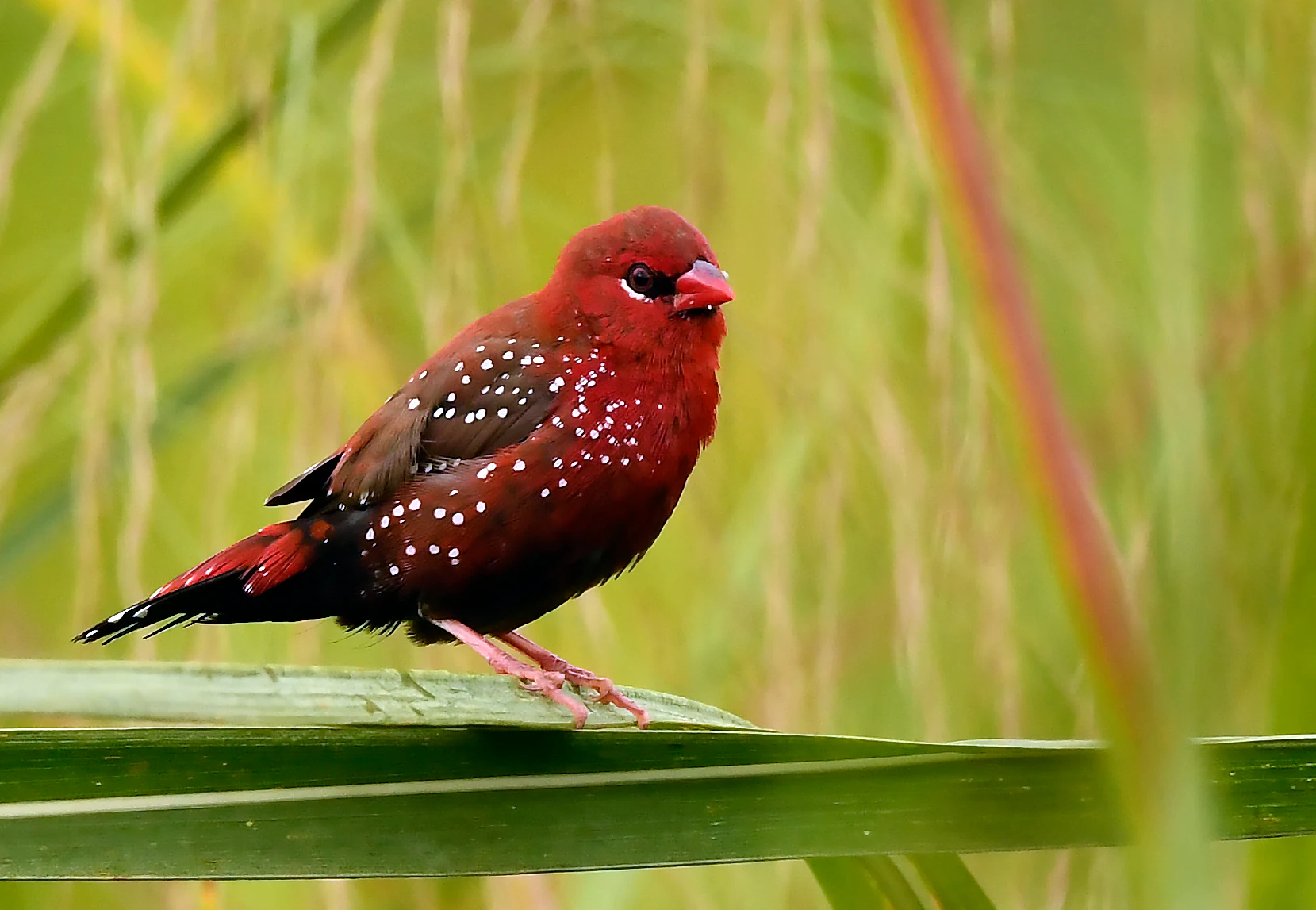
A small bird with dark red feathers and white spots perched on a green reed in a wetland environment.
A male Red Avadavat, a small migratory songbird, perched in the grasslands of Haiderpur Wetland.

Haiderpur Wetland history and protected-area timeline

Haiderpur Wetland did not exist as a formal ecological area until the mid-1980s. It was created in 1984 as a direct consequence of the construction of the Madhya Ganga Barrage on the Ganges, which raised water levels in the surrounding floodplain and produced one of the largest human-made wetlands in the region.

Over the following decades, the wetland gradually became recognised for its ecological importance, especially for migratory birds using the Central Asian Flyway. Conservation efforts by wildlife activists and local communities helped shape its identity as a refuge for waterbirds, gharials, and other native wildlife.

A milestone came in April 2021, when Haiderpur was formally designated as a Ramsar Wetland of International Importance, becoming the 47th Ramsar site in India under reference number 2463. This status brought the wetland into the global system of internationally significant wetlands and strengthened its protection profile under the Uttar Pradesh Forest Department.

Haiderpur Wetland landscape and geographic character

The landscape of Haiderpur is defined by the Ganges floodplain. The Madhya Ganga Barrage, built across the river, regulates the flow of water into a wide network of channels and pools that form the core of the wetland. The Solani River, a tributary of the Ganges, enters this system and adds to the seasonal variation in water levels.

Geographically, the area sits within the flat alluvial terrain of the upper Gangetic plain. Rather than hills or dramatic relief, the dominant features are open sheets of water, reed-fringed marshlands, exposed mudflats during the dry season, and elevated edges of grassland and woodland that transition into the surrounding agricultural landscape. These topographic changes, even if subtle, create the habitat mosaic that the wetland's wildlife depends on.

When water levels rise during the monsoon and post-monsoon period, large parts of the lower-lying sanctuary become temporarily flooded, expanding the effective wetland footprint. As waters recede in the colder months, exposed sediments and shallow pools attract feeding flocks of waterbirds, giving the landscape a very different seasonal character from the lush green of the wet season to the more open, congregated birdlife of winter.

Haiderpur Wetland ecosystems, habitats, and plant life

Ecologically, Haiderpur is best understood as a dynamic freshwater wetland embedded within a larger protected landscape. The combination of standing water, flowing channels, marshes, and adjacent terrestrial habitats gives it a layered structure that supports an unusually wide variety of species.

Aquatic and semi-aquatic habitats form the core of the wetland's ecological value. Submerged and emergent vegetation, reeds, and seasonal grasses provide cover for fish, amphibians, and invertebrates, which in turn sustain waterbirds, turtles, and larger reptiles. The fringes of the wetland grade into grasslands and light woodland that belong to the broader Hastinapur Wildlife Sanctuary, allowing species to move between aquatic and dry-land environments.

The seasonal pulse of the Ganges is the main driver of the wetland's ecological character. Monsoon inflows raise water levels and refresh the habitat, while the slower post-monsoon retreat exposes feeding grounds and resting sites for migratory birds. This natural rhythm makes Haiderpur a textbook example of a floodplain wetland whose biodiversity depends directly on the river's flow.

Haiderpur Wetland wildlife and species highlights

Haiderpur's wildlife profile is dominated by birds. The wetland hosts more than 320 recorded species, ranging from common residents such as kingfishers, mynas, bulbuls, sparrows, and Baya weavers to globally significant winter visitors and passage migrants. Waders, ducks, cranes, spot-billed ducks, falcons, hawks, and eagles feature prominently, along with nightingale, cuckoo, and various partridge and quail species in the surrounding habitat.

The mammal community is similarly diverse, as the wetland sits within a sanctuary rather than an isolated aquatic reserve. Nilgai, wild boar, jackal, fox, mongoose, and honey badger are regularly recorded, alongside smaller species such as rabbits, muskrats, and bats. Larger predators including leopard and wolf pass through the broader area, while primates add to the mammal richness.

Reptiles are a highlight of the wetland. Monitor lizards, Indian pythons, cobras, kraits, and vipers are present in meaningful numbers. Of particular conservation importance is the resident population of the critically endangered gharial, which inhabits the water and adjoining river channels. Several vulnerable amphibian species also depend on the wetland's seasonal pools, reinforcing its role as a refuge for moisture-dependent fauna in an otherwise heavily cultivated landscape.

Haiderpur Wetland conservation status and protection priorities

Conservation at Haiderpur takes place on multiple levels. The wetland is managed by the Uttar Pradesh Forest Department and lies within the legally protected framework of the Hastinapur Wildlife Sanctuary, which restricts destructive land use across its area.

Its most prominent international recognition is Ramsar status, granted in April 2021 under reference number 2463, making it India's 47th designated wetland of international importance. This designation places Haiderpur within the global system of wetlands recognised under the Ramsar Convention for their ecological, hydrological, and biodiversity values.

Beyond formal designations, the wetland has benefited from sustained advocacy by wildlife activists and local communities. Organisations such as the World Wide Fund for Nature have collaborated with the government on schemes aimed at habitat management, species protection, and community engagement. These efforts are particularly important for gharial conservation, the protection of migratory bird habitat, and the maintenance of the seasonal hydrological cycle on which the broader wetland ecosystem depends.

Haiderpur Wetland cultural meaning and human context

Haiderpur's cultural context is shaped by its position in the upper Gangetic plain, a region deeply tied to the Ganges as both a hydrological force and a cultural symbol. The wetland's very existence is a product of mid-twentieth-century river engineering, embedding the site within broader histories of irrigation, water management, and development in northern India.

The locality also lies near Hastinapur, a place long associated with the Mahabharata epic as the legendary capital of the Kauravas. While the wetland itself is a modern ecological feature, the surrounding landscape carries strong associations with traditional North Indian cultural geography, giving the region an identity that blends natural heritage and mythological resonance.

Top sights and standout views in Haiderpur Wetland

Haiderpur's strongest distinguishing qualities are its size as one of India's larger human-made wetlands, its Ramsar status, and its role as a major stopover on the Central Asian Flyway. The combination of open water, marsh, and surrounding sanctuary creates an unusually productive habitat in a heavily populated and farmed region.

The presence of the gharial, a critically endangered crocodilian, in the adjoining river channels elevates the wetland's conservation profile beyond waterbirds alone. Together with over 320 recorded bird species, diverse mammals, and a rich reptile and amphibian fauna, Haiderpur offers a compact but ecologically dense example of North Indian floodplain biodiversity.

Best time to visit Haiderpur Wetland

The most rewarding time to experience Haiderpur is during the cooler months, roughly from late autumn through winter, when migratory waterbirds arrive along the Central Asian Flyway. Falling water levels expose mudflats and shallow pools that concentrate flocks of ducks, cranes, waders, and raptors, making birdwatching particularly productive.

The monsoon and immediate post-monsoon period transforms the wetland into a much more expansive, lushly flooded landscape, which is visually striking and ecologically important but can make access and viewing more challenging. Spring offers a transitional phase, with retreating waters and an active resident bird community before the heat of summer sets in.
Monthly climate preview

Long-term representative point measurements tracking monthly temperature and precipitation variation

Haiderpur Wetland Climate Normals, Annual Temperature and Precipitation Rhythm

Representative coordinate records show average monthly temperatures ranging from 13.73 degrees Celsius to 34.71 degrees Celsius alongside distinct precipitation variations across the year. Reviewing the complete twelve-month profile provides deeper insight into long-term climate patterns measured at this location.
Annual mean25 °C
14 °C35 °C
Jan14°
Feb17°
Mar23°
Apr29°
May34°
Jun35°
Jul31°
Aug29°
Sep27°
Oct24°
Nov19°
Dec15°
Warmest month
June

34.7 °C

Coolest month
January

13.7 °C

Wettest month
July

10.1 mm/day

Driest month
November

0.2 mm/day

Park location guide

Geography guide, regional context, and park location map for Haiderpur Wetland

Haiderpur Wetland park geography, regions, and map view in India

Understand where Haiderpur Wetland sits in India through a broader geographic reading of the surrounding landscape, nearby location context, and its mapped position within the national park landscape.

How Haiderpur Wetland fits into India

India is a South Asian country bordered by the Indian Ocean, Arabian Sea, and Bay of Bengal. It shares land borders with Pakistan, China, Nepal, Bhutan, Bangladesh, and Myanmar. The country has a population of over 1.4 billion people and operates as a federal parliamentary republic with its capital in New Delhi.

Wider geography shaping Haiderpur Wetland in India

India occupies the Indian subcontinent in South Asia, bordered by the Arabian Sea to the southwest, the Bay of Bengal to the southeast, and the Indian Ocean to the south. It shares land borders with Pakistan to the west, China, Nepal, and Bhutan to the north, and Bangladesh and Myanmar to the east. The territory also includes the Andaman and Nicobar Islands in the Indian Ocean.

Map view of Haiderpur Wetland

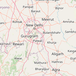
Use this park location map to pinpoint Haiderpur Wetland in India, understand its exact geographic position, and read its mapped placement within the surrounding landscape more clearly.

Pigeon | © OpenStreetMap contributors

Location context for Haiderpur Wetland

Uttar Pradesh
Recorded earthquake history

Explore the Historical Earthquake Record for Haiderpur Wetland

Review the documented seismic history associated with the geography of Haiderpur Wetland. Access a curated catalogue of past earthquake events with data on magnitude and distance from the park to better understand the regional seismic context recorded by local monitoring efforts.

Haiderpur Wetland Earthquake History

Catalogued events

3 events

Strongest magnitude

Magnitude 4.9

Most recent event

Nov 8, 2007

This history includes earthquakes recorded inside the park or within 50 km of its borders

Visualizing floodplain habitats and protected waterbird sanctuaries

Haiderpur Wetland Photos and Landscape Scenery

Explore high-resolution photography showcasing the open water channels, marshlands, and seasonal mudflats of Haiderpur Wetland. Visual documentation helps researchers and conservationists examine the protected terrain and diverse habitats supporting major migratory flyways.

A small bird with dark red feathers and white spots perched on a green reed in a wetland environment.

A group of Painted Storks, a white egret, and a dark-colored cormorant standing on the muddy banks of a shallow wetland.

Park atlas

Compare surrounding river floodplains and related wildlife sanctuaries across northern India.

Exploring Parks Near Haiderpur Wetland and Connected Regional Protected Areas

Browse other protected areas and wetland habitats situated within the upper Gangetic plain. Expanding the search helps connect regional conservation landscapes and riverine ecosystems.
National parkUttarakhand
60 km away#1 closest

East

Jim Corbett National Park: Uttarakhand National Park and Protected Landscape Atlas

Mapped Boundaries and Regional Geographic Context

Jim Corbett National Park offers a specific entry point for understanding protected landscapes and their geographic significance. As a designated national park within Uttarakhand, India, it provides a distinct case study for exploring mapped boundaries and regional natural terrain. This detailed view allows for a deep dive into the park's identity as a protected area, highlighting its placement within the larger atlas of India's natural heritage and its contribution to the Himalayan geographic narrative.

Area
1,288.31 km²
Established
1936
IUCN
II
Visitors
365K annual
National parkUttarakhand
About 68 km away#2 closest

North

Rajaji National Park: Uttarakhand National Park and Tiger Reserve Landscape

Sivalik Hills geography and protected area context

Rajaji National Park is a vital protected landscape situated in the Uttarakhand region of India, recognized as both a national park and a tiger reserve. Its territory spans across the Sivalik Hills, offering a diverse terrain characterized by deciduous forests and riparian ecosystems. The park's location along the Ganga river significantly influences its ecology, providing a unique geographic context for its protected status and wildlife significance.

Area
820.5 km²
Established
1983
IUCN
II
Relief
Highland
National parkHaryana
About 108 km away#3 closest

Northwest

Kalesar National Park: Exploring Haryana's Unique Sal Forest Protected Landscape

Discover mapped terrain and regional geography within the Shivalik foothills.

Kalesar National Park, located in the Shivalik foothills of Haryana, is a crucial protected area renowned for its natural sal forest, a rare ecological feature in the state. Spanning approximately 53 square kilometers, the park's diverse terrain offers insights into regional geography and conservation, serving as a vital habitat for leopards and a corridor for wild elephants. Its mapped boundaries encompass a unique landscape that contrasts sharply with surrounding agricultural lands, making it a significant point of study for protected-area enthusiasts.

Area
53 km²
Established
2003
IUCN
IV
Relief
Highland
Watercolor painting of a calm body of water surrounded by greenery and distant mountains under a light sky.
Wildlife reserveUttarakhand
109 km away#4 closest

North

Asan Conservation Reserve: Protected Wetland and Reservoir Geography in Uttarakhand

Mapping the landscape of North India's premier Ramsar site

Located in the Doon Valley of Uttarakhand, Asan Conservation Reserve creates a distinct natural refuge within a working hydrological system. This wildlife reserve features shallow reservoir basins and marshy shorelines, providing a key corridor for migratory bird species and serving as an anchor for regional conservation efforts.

Area
4 km²
Established
1967
Water
Water-dominated
Season
Year-round
National parkIndia
About 118 km away#5 closest

Northwest

Simbalbara National Park: National Park in India's Himalayan Foothills

Explore its dense sal forests and unique terrain.

Simbalbara National Park is a protected area recognized for its extensive sal forests and its role as a vital habitat for tigers and other large mammals in the Himalayan foothills of India. The park's landscape is defined by the Kiyarda Dun valley, featuring a mix of dense forest-covered slopes, open grassy glades, and a perennial stream. This protected area offers a representative sample of the sal-dominated forest ecosystems at lower Himalayan elevations, providing a distinct geographic and ecological context for exploration.

Area
27.88 km²
Established
2010
IUCN
II
Relief
Upland
Watercolor painting of a lake surrounded by palms, reeds, and soft hills in the background.
Wildlife reserveHimachal Pradesh
About 136 km away#6 closest

North

Renuka Sanctuary: Protected Wildlife Reserve and Ramsar Wetland Site in Himachal Pradesh

Ecological catchment and forest basin in the low Himalayan hills

Renuka Sanctuary is a dedicated wildlife reserve in Himachal Pradesh defined by the expansive Renuka Lake and its surrounding dry deciduous forest cover. This Ramsar wetland area protects the critical catchment zone of the state's largest natural lake, offering a unique intersection of conservation land and culturally significant natural terrain.

Area
4.028 km²
Water
Major water bodies
National parkHaryana
146 km away#7 closest

Southwest

Sultanpur National Park: Haryana's Designated Protected Landscape and Atlas Context

Mapped boundaries and regional geographic significance.

Delve into Sultanpur National Park, an important protected area within Haryana, India, viewed through an atlas and map-driven lens. This entry details the park's designation as a national park, offering insights into its specific geographic footprint and its relation to the surrounding regional terrain. Understand how Sultanpur National Park contributes to the protected landscape mosaic of North India, providing critical data for those exploring India's geography and conservation areas.

Area
1.43 km²
Established
1991
IUCN
II
Relief
Lowland
Wildlife reserveHaryana
167 km away#8 closest

Southwest

Bhindawas Wildlife Sanctuary: Protected Wetland Mapping and Regional Landscape Context

A key Ramsar site within the Sahibi River ecological corridor of Haryana

Examine the geographic footprint of Bhindawas Wildlife Sanctuary, a significant 412-hectare wetland in Haryana. This protected area supports dense migratory waterbird populations by maintaining a stable aquatic environment through an engineered network of canals and natural rainfall. The sanctuary stands as an essential component of the regional forest and wetland chain linking the Aravalli hills to the Yamuna floodplain.

Area
4.12 km²
Established
1986
IUCN
IV
Relief
Lowland

Common questions about visiting, size, designation, and location context for Haiderpur Wetland

Haiderpur Wetland FAQs for park facts, access, geography, and protected area context

Find quick answers about Haiderpur Wetland, including protected-area facts, park geography, trail and visitor context, and how the park fits into its surrounding country and regional landscape.
MoriAtlas Explorer

Continue Your Protected Areas Search Across the Global Atlas

Deepen your exploration by continuing the structured search for national parks and protected areas worldwide. Utilize the comprehensive filtering capabilities to compare different conservation landscapes and refine your understanding of global park geography. Discover more about the distribution and characteristics of protected natural areas.

Global natural geography