
Mori Atlas logo
National parkHainich National Park

Mapping the primary deciduous woodlands and ecological corridors of central Germany

Hainich National Park: Examining the Protected Ancient Beech Forest Geography in Thuringia, Germany

(Nationalpark Hainich)

Hainich National Park represents a significant protected area in the central German state of Thuringia, encompassing a vast expanse of ancient beech forest that serves as a cornerstone of the regional ecology. This protected landscape contains some of the last remaining primeval woodland in central Europe, characterized by rolling hills and diverse forest successional stages. Detailed mapping of the park reveals an intricate mosaic of old-growth stands and regenerated environments that define this essential wilderness corridor between the cities of Eisenach and Mühlhausen.

Ancient Beech ForestCentral Europe WildernessUNESCO World Heritage SiteGerman National ParkDeciduous ForestThuringia
Illustration showing a mountainous landscape with a river, waterfall, and forest.

Hainich National Park

National park

Park overview

Structured park overview, official facts, and landscape profile for Hainich National Park

Hainich National Park park facts, protected area profile, and essential visitor context

Review the core facts for Hainich National Park, including designation, size, terrain, visitor scale, habitats, and operating context in one park-focused overview.

About Hainich National Park

Hainich National Park represents a bold experiment in rewilding, aiming to restore a large section of central European forest to its primordial state. The park occupies terrain that was formerly used as a military training area, with approximately 50 square kilometers of deciduous forest that had been relatively undisturbed during the later decades of the 20th century. Unlike most German forests that are actively managed, Hainich allows natural processes to proceed without intervention, enabling the beech forest to develop according to ecological dynamics that have characterized European woodlands for millennia. The park forms part of a broader European network of old-growth beech forests recognized by UNESCO, connecting Hainich to similar protected areas across the Carpathians and other regions. Visitors can experience this wilderness through a network of trails, the prominent canopy walkway at Thiemsburg, and the Hainichblick observation tower that provides panoramic views across the regenerating forest landscape.

Quick facts and research context for Hainich National Park

Hainich National Park covers 75 square kilometers of former military training ground in Thuringia, Germany. It contains the nation's largest contiguous deciduous forest and was established in 1997 as the 13th German national park. In 2011, the park was inscribed as a UNESCO World Heritage Site as part of the Ancient and Primeval Beech Forests of the Carpathians and Other Regions of Europe. The park's core zone was expanded from 29% to 75% of its area in 2009, and over 4,875 hectares are certified as Wild-forest areas by the European Wilderness Society.

Protection and recognition

Documented terrestrial protection scope, management framework, and Natura 2000 recognition sources

Hainich National Park Protection Status and International Recognition

Terrestrial protection status, management scope, and official international designations define the conservation framework for Hainich National Park. Documented recognition sources include Natura 2000 records that outline the environmental administration governing this protected area.

International recognition

Protection details

Protection scope
Terrestrial
Transboundary protection
No
Park context

Deeper park guide and search-rich context for Hainich National Park

Hainich National Park history, landscape, wildlife, and travel context

Explore Hainich National Park through its history, landscape character, ecosystems, wildlife, conservation priorities, cultural context, and seasonal travel timing in a structured park guide built for atlas discovery and search intent.

Why Hainich National Park stands out

Hainich is best known for its exceptional ancient beech forests that have been allowed to develop naturally without human intervention, representing a rare example of primary forest in central Europe. The park is distinguished by its canopy walkway, a 530-meter elevated path that allows visitors to walk through the forest canopy near Thiemsburg, one of only two such structures in Germany when it was built. The presence of European wildcats, 15 bat species, and over 500 wood beetle species underscores the ecological significance of this large, unmanaged forest block. The park's designation as a UNESCO World Heritage site acknowledges its role as testimony to the ecological history of beech and forest dynamics in Europe since the Last Glacial Period.
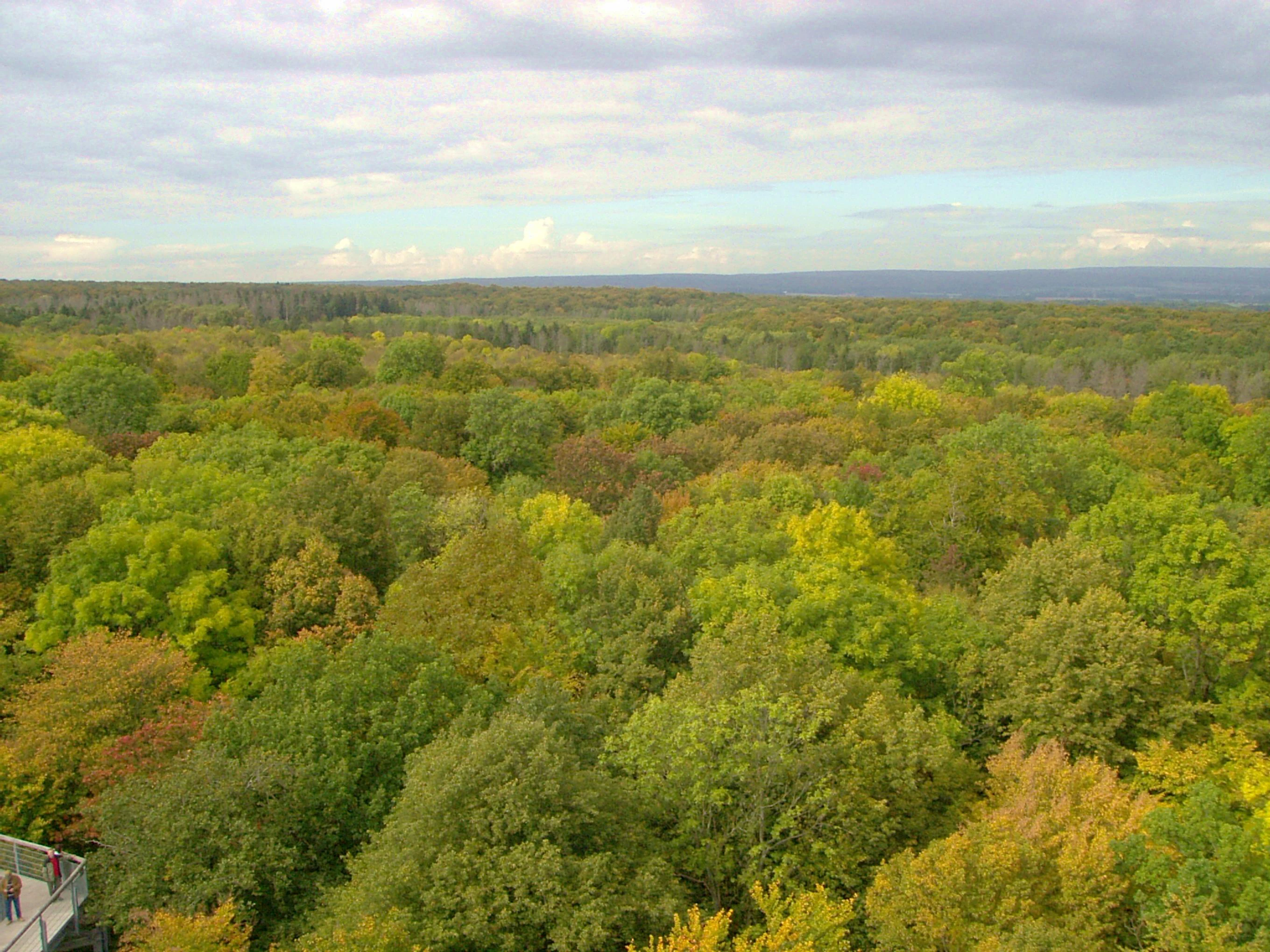
Aerial view of dense forest with green and yellow foliage under a partly cloudy sky, with a small section of a walkway visible on the left.
Colorful treetops of Hainich National Park viewed from the Krähennest canopy walkway.

Hainich National Park history and protected-area timeline

Hainich National Park was established on December 31, 1997, becoming the thirteenth national park in Germany and the first and only such protected area in Thuringia. The park was created on land that had served as a military training ground, where decades of military use had inadvertently created conditions favorable to forest preservation. Following German reunification in 1990, the opportunity arose to convert this former military territory into a national park with the goal of allowing natural forest dynamics to restore the landscape. A significant expansion of the core protection zone occurred in July 2009, when the strictly protected area was increased from 29% to 75% of the park's total area, reflecting a strengthened commitment to wilderness preservation. The park's global significance was recognized in 2011 when it was added to the UNESCO World Heritage Site of Ancient and Primeval Beech Forests of the Carpathians and Other Regions of Europe.

Hainich National Park landscape and geographic character

The park occupies a gently rolling landscape in western Thuringia, characterized by deciduous forest covering the hills and valleys between Eisenach, Mühlhausen, and Bad Langensalza. The terrain forms part of the larger Hainich upland, the largest contiguous deciduous forest area in Germany. The landscape includes areas that were cleared for military training in the early 1980s, which have since regenerated into young forest, creating a mosaic of mature old-growth woodland, middle-aged stands, and early successional areas. The southern portion of the park features a vast area where extensive clearing for military purposes created open ground that has since developed into a twenty-year-old young forest. The western section around the Harsberg offers higher ground with expansive views, while the eastern portion around Thiemsburg contains the canopy walkway that provides access to the forest canopy at elevations of 10 to 24 meters above ground.

Two red beetles on a green leaf
Red beech leaf beetles on a green leaf in Hainich National Park

Hainich National Park ecosystems, habitats, and plant life

The ecological character of Hainich is defined by its extensive beech-dominated forest communities, representing a continuum from ancient old-growth stands to areas of more recent natural regeneration. European beech forms the dominant tree species, creating the layered canopy structure typical of central European deciduous forests. The forest also contains significant populations of ash trees, hornbeams, limes, maples, and the rare elsbeere. The understory supports a remarkable diversity of spring-flowering plants including spring snowflake, corydalis, liverleaf, early dog-violet, buttercup anemone, and wild garlic. The park's fungal diversity is exceptional, with over 1,600 species recorded to date and an expected total exceeding 3,000 when including lichen-forming species. Approximately 300 of the fungi are endangered or threatened with extinction, with some found nowhere else in Thuringia or extremely rare throughout Germany.
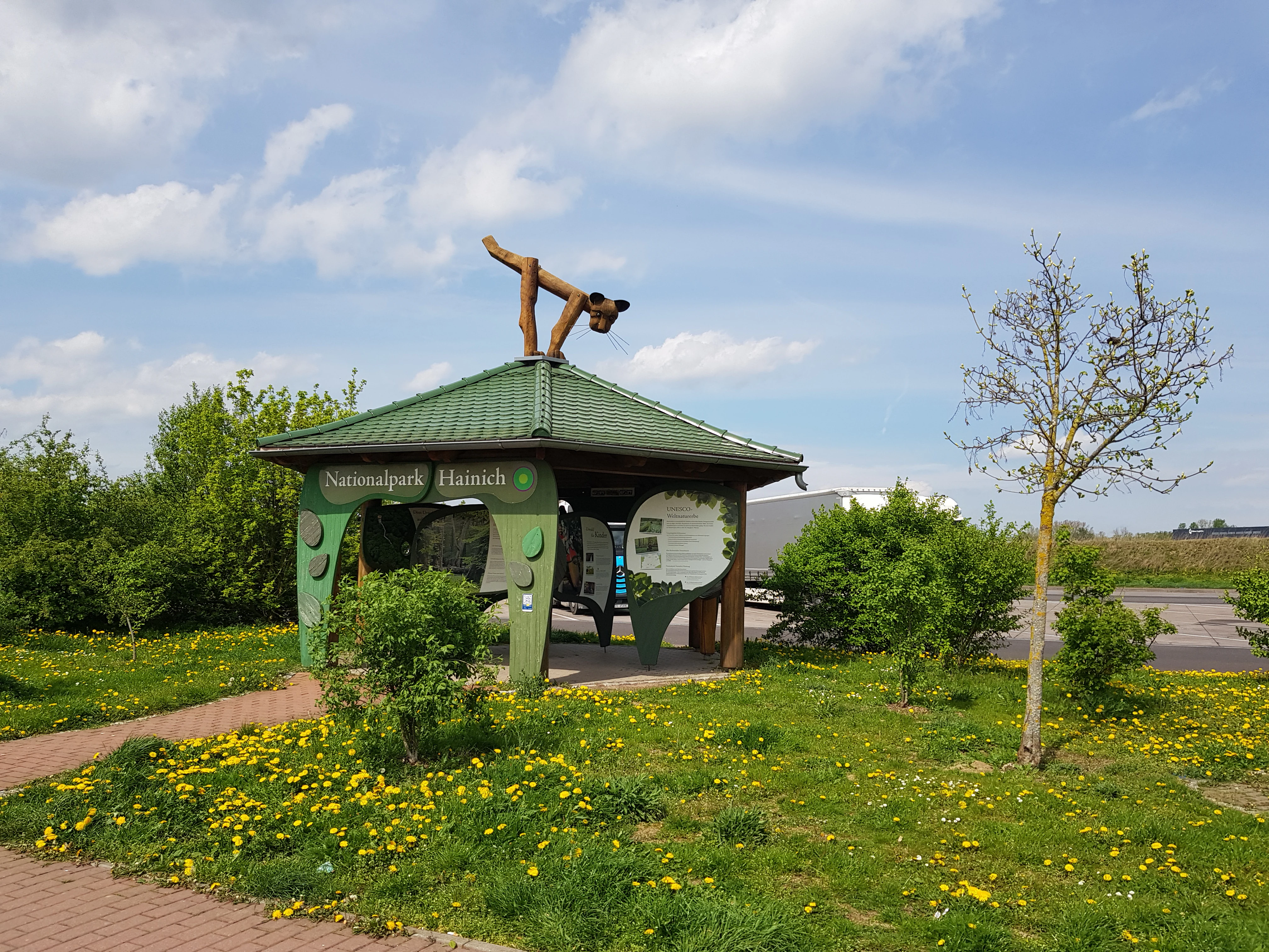
Green-roofed information pavilion for Hainich National Park with a wildcat sculpture on the roof, surrounded by grass with yellow flowers and trees
Information pavilion for Hainich National Park featuring a wildcat symbol on the roof

Hainich National Park wildlife and species highlights

Hainich supports a diverse fauna characteristic of mature deciduous forests in central Europe. The European wildcat, a shy and secretive predator, inhabits the park and serves as its symbol. Fifteen species of bats roost and hunt within the forest, utilizing the hollow trees and canopy spaces. Seven species of woodpeckers are present, including several species that require large deadwood substrates for nesting. The park is home to more than 500 species of wood beetles, representing a significant component of the invertebrate fauna that depends on decaying wood. These beetle communities play crucial roles in nutrient cycling and decomposition processes that sustain forest health. The invertebrate diversity extends to numerous insect species that form the base of the food web supporting the park's vertebrate fauna.
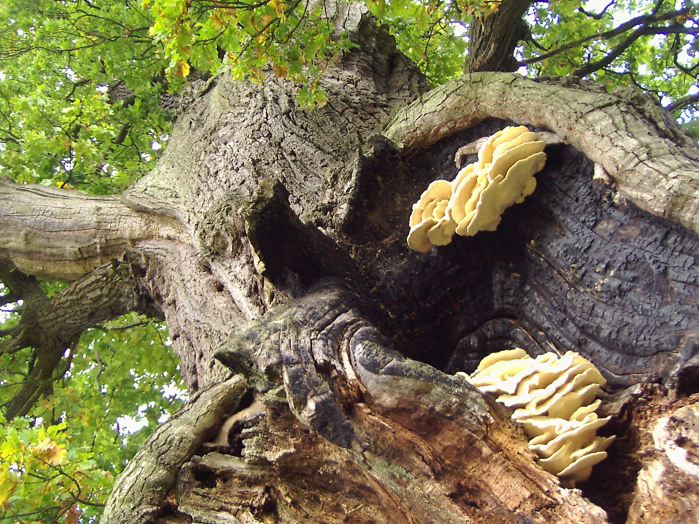
Close-up view of a large oak tree trunk with yellow fungi growing on its surface
Thick oak tree trunk with fungi in Hainich National Park

Hainich National Park conservation status and protection priorities

Hainich National Park embodies a conservation philosophy focused on allowing natural processes to restore ecosystem function without human management. The park represents Germany's contribution to a transnational network of old-growth beech forests recognized as World Heritage, acknowledging its global significance for preserving representative examples of Europe's forest ecosystems. The 2009 expansion of the core zone to 75% of the park's area marked a substantial commitment to wilderness protection, exceeding typical standards for German national parks. Nearly 4,875 hectares within the core zone have achieved certification as Wild-forest areas by the European Wilderness Society, recognizing their unmanaged, natural character. The protection of rare and endangered fungi, some found only in Hainich within Thuringia, creates special conservation responsibilities. The park serves as a living laboratory for understanding forest dynamics, with the University of Göttingen conducting ongoing geobotanical canopy research.

Hainich National Park cultural meaning and human context

While primarily focused on natural landscape preservation, Hainich contains elements of human heritage within its boundaries. The northern portion of the park features the Hünenburg area with the Hünenteich, where a Germanic cultural path was established in 2009. This trail features reconstructions of religious sites and sanctuaries discovered through excavations at the nearby Opfermoor Niederdorla, a sacrificial site that provides insight into Iron Age and Roman period religious practices in the region. The park encompasses areas that were part of the former Eisenach district, with several small villages and rural settlements along its edges. The landscape has been shaped by centuries of human use, transitioning from agricultural and forestry purposes to military training before becoming a protected wilderness.
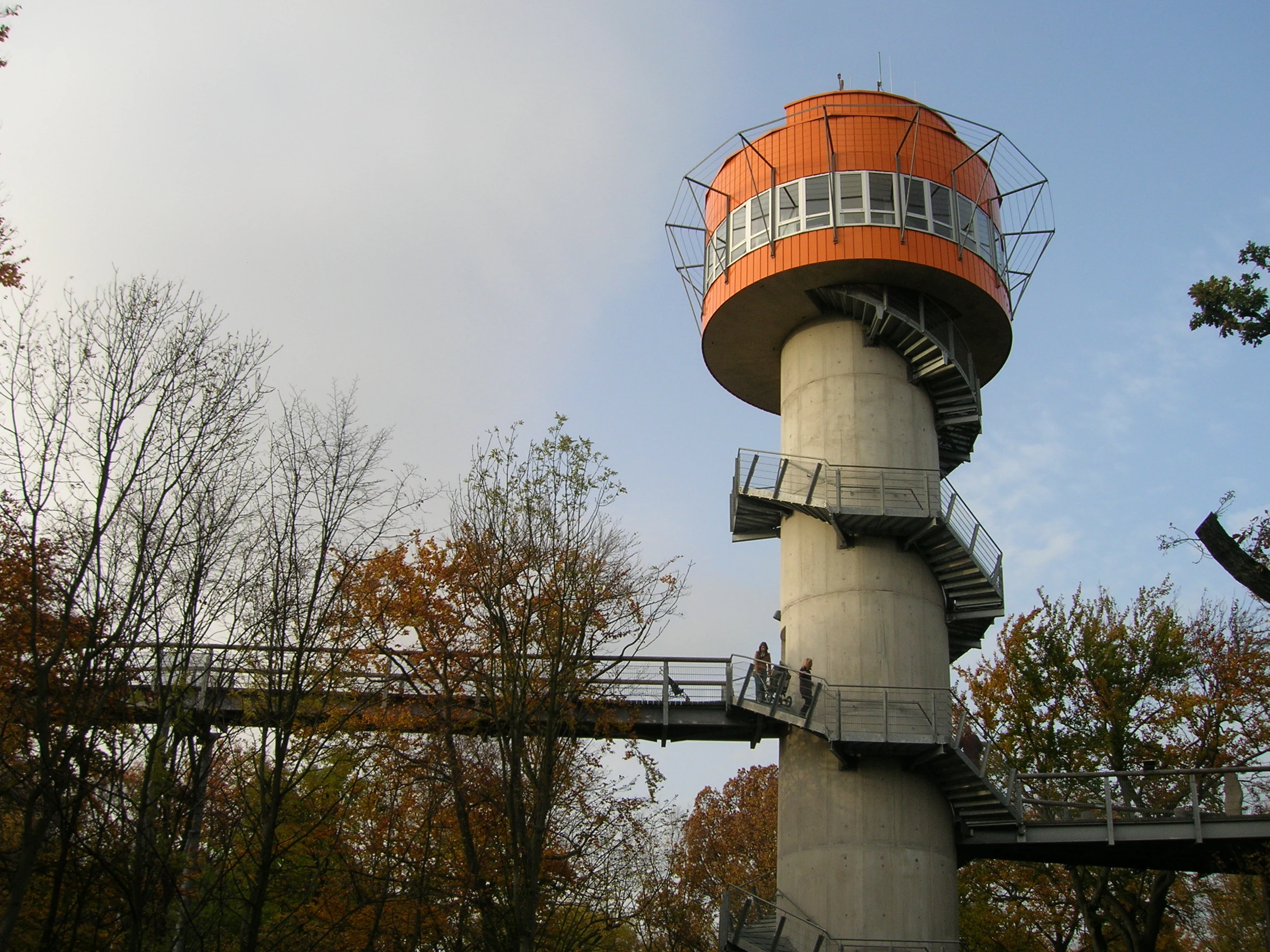
Observation tower with spiral staircase and connecting walkway surrounded by trees with autumn foliage
Viewing tower on the treetop path in Hainich National Park

Top sights and standout views in Hainich National Park

The canopy walkway at Thiemsburg remains the park's signature visitor experience, offering unprecedented access to the forest canopy at heights of 10 to 24 meters, with the path extending 530 meters through the tree crowns. The Hainichblick observation tower, opened in June 2011, provides sweeping views across the regenerating southern forest area from the Generalshügel. The Urwald-Life-Camp at Harsberg offers educational programs for school groups and youth, while the Germanen Kultpfad provides a historical perspective on the region's ancient religious heritage. The visitor center in Bad Langensalza serves as the main gateway to the park, providing interpretation and orientation for visitors. The network of marked trails, including themed routes, allows visitors to explore the diverse forest environments and learn about the park's ecological restoration goals.
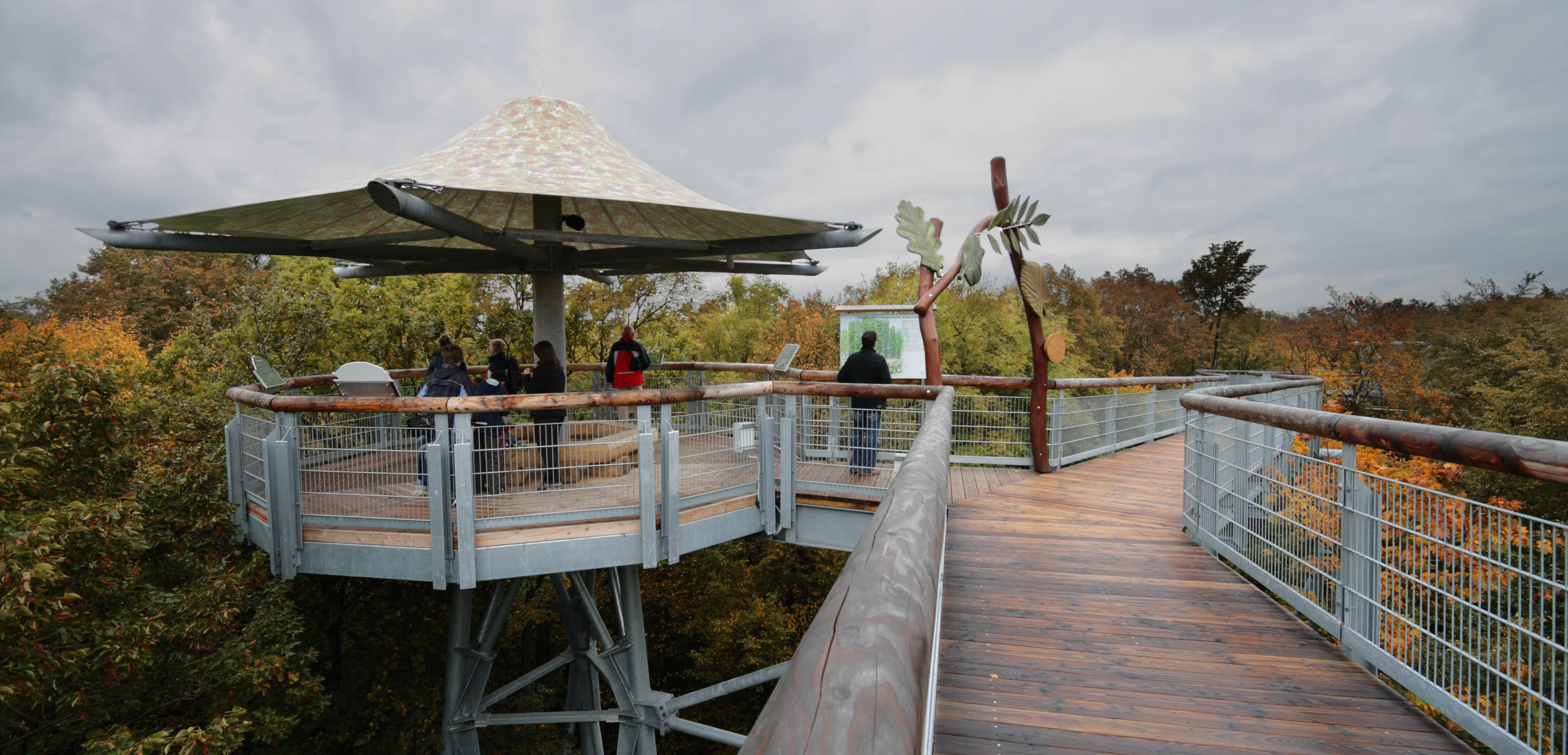
Wooden observation platform with a roof structure, part of a treetop walkway, surrounded by forest with several people visible on the platform
Information platform on the treetop walk in Hainich National Park

Best time to visit Hainich National Park

The park can be enjoyed throughout the year, though each season offers distinct experiences. Spring brings spectacular displays of wildflowers including spring snowflake, liverleaf, and buttercup anemone carpeting the forest floor, particularly impressive in April and May when the beech canopy has not yet fully leafed out. Summer offers full canopy cover and the opportunity to experience the canopy walkway with maximum leaf development, though trails can be warm. Autumn provides colorful foliage as the beech leaves turn golden and the forest floor becomes carpeted with fallen leaves. Winter offers a different perspective on the forest structure, with fewer visitors and the stark beauty of bare trees and the possibility of snow-covered trails. The visitor center in Bad Langensalza is open year-round, while trail conditions vary seasonally.


Monthly climate preview

Measured monthly temperature ranges and precipitation patterns across representative coordinates

Hainich National Park Climate Normals and Long Term Weather by Month

Long term climate data for Hainich National Park reveals a measured annual cycle of monthly temperature variations and consistent precipitation amounts. Reviewing these representative point measurements establishes a solid baseline for understanding the broader environmental conditions found throughout the region.
Annual mean8 °C
-1 °C18 °C
Jan-1°
Feb
Mar
Apr
May12°
Jun16°
Jul18°
Aug18°
Sep14°
Oct
Nov
Dec
Warmest month
July

18.4 °C

Coolest month
January

-1.3 °C

Wettest month
July

2.6 mm/day

Driest month
April

1.4 mm/day

Park location guide

Geography guide, regional context, and park location map for Hainich National Park

Hainich National Park park geography, regions, and map view in Germany

Understand where Hainich National Park sits in Germany through a broader geographic reading of the surrounding landscape, nearby location context, and its mapped position within the national park landscape.

How Hainich National Park fits into Germany

Germany is a federal republic in Western and Central Europe with a population of over 83 million across sixteen constituent states. It is Europe's largest economy by nominal GDP and a major global exporter and importer. The capital is Berlin, and the country borders Denmark, Poland, Czech Republic, Austria, Switzerland, France, Luxembourg, Belgium, and the Netherlands.

Wider geography shaping Hainich National Park in Germany

Germany is located in Western and Central Europe, spanning 357,022 km². It borders Denmark to the north, Poland and the Czech Republic to the east, Austria and Switzerland to the south, and France, Luxembourg, Belgium, and the Netherlands to the west. The country has coastlines on the Baltic Sea and North Sea to the north, with the Alps located in the southern region.

Map view of Hainich National Park

Use this park location map to pinpoint Hainich National Park in Germany, understand its exact geographic position, and read its mapped placement within the surrounding landscape more clearly.

Pigeon | © OpenStreetMap contributors

Location context for Hainich National Park

Thuringia
Natural feature types

Explore the Diverse Natural Landscape Features of Hainich National Park

Investigate the complex geography of Hainich National Park by browsing its mapped natural features and protected landforms. MoriAtlas provides a structured path to understand the diverse terrain and ancient forest dynamics within this central German wilderness.
Recorded earthquake history

Explore Historical Earthquake Records Associated with Hainich National Park

Access a structured collection of historical seismic data recorded near Hainich National Park. This MoriAtlas resource provides context on regional earthquake activity, enabling the observation of historical events in relation to the park geography without implying future hazard or risk.

Hainich National Park Earthquake History

Catalogued events

4 events

Strongest magnitude

Magnitude 3.6

Most recent event

Oct 25, 2006

This history includes earthquakes recorded inside the park or within 50 km of its borders

Visual reference collection showcasing ancient beech forest terrain and habitat character

Hainich National Park Photos and Protected Landscape Scenery

Protected area photography captures the dense deciduous canopy, rolling upland terrain, and regenerating woodland mosaic unique to this central German wilderness. Detailed visual records help researchers and travelers examine forest structures, habitat zones, and natural scenery across the region.

Aerial view of dense forest with green and yellow foliage under a partly cloudy sky, with a small section of a walkway visible on the left.

Low-angle view of a tall beech tree trunk with green foliage and sunlight filtering through the canopy

Two red beetles on a green leaf

Green-roofed information pavilion for Hainich National Park with a wildcat sculpture on the roof, surrounded by grass with yellow flowers and trees

Close-up view of a large oak tree trunk with yellow fungi growing on its surface

Yellow wooden sign featuring black owl logo and 'Nationalpark Hainich' text, set against grassy field with tree in background

Observation tower with spiral staircase and connecting walkway surrounded by trees with autumn foliage

Wooden observation platform with a roof structure, part of a treetop walkway, surrounded by forest with several people visible on the platform

Aerial view of an elevated walkway winding through a dense green forest with a viewing platform visible along the path

Red and black striped insect on white wildflowers with green foliage background

Dirt trail junction in a forested area with a wooden shelter structure, surrounded by green trees and grass under a partly cloudy sky

Aerial view of a metal treetop walkway extending through a dense green forest

Wooden signpost with 'Hainich' text, metal gate, gravel path, and forest background

Tree trunk with multiple bracket fungi attached to bark, surrounded by forest vegetation.

A close-up of a beetle with black and yellow stripes on white flowers

Elevated wooden walkway with metal railings surrounded by dense green forest canopy

Park atlas

Compare regional forest reserves and adjacent central European wilderness landscapes

Explore Parks Near Hainich National Park and Surrounding Protected Areas

Browse nearby national parks and protected landscapes to continue comparing central European woodland ecosystems. Regional park data reveals surrounding terrain connections across the wider Thuringian upland zone.
A watercolor painting of a rolling, forested landscape with soft green and pink tones, featuring gentle hills and vegetation.
National parkThuringia
Park boundaries overlap#1 closest

Southeast

Nationalpark Hainich: Exploring the Geography of Thuringia's Beech Forest Wilderness

Mapped protected landscapes in the German heartland

Nationalpark Hainich protects one of the most important remaining deciduous woodlands in Central Europe. This detailed atlas entry covers the park's rolling terrain, the transition of its former training grounds into wild forest, and the geographic context of its position within the broader Thuringian landscape.

Area
75 km²
Established
1997
Relief
Upland
Climate
Temperate
Nature reserveThuringia
2.1 km away#2 closest

West

Werra bis Treffurt mit Zuflüssen: Protected River and Floodplain Network in Thuringia

Mapping an extensive 191 kilometer Natura 2000 river corridor.

The Werra bis Treffurt mit Zuflüssen protected area serves as a vital ecological corridor in Thuringia. This site encompasses a complex mosaic of fast-flowing highland brooks, expansive floodplain meadows, inland salt sites, and rare dissolution lakes. Its geography bridges high-altitude source regions with lower river valleys, creating a distinctive landscape transect that supports essential freshwater habitats and rare aquatic species across the state.

Area
22.6 km²
Established
2008
IUCN
IV
Relief
Mixed relief
Nature reserveThuringia
4.6 km away#3 closest

Northwest

Werrahänge von Frankenroda bis Falken: A Deep Dive into Thuringian Protected Landscapes

Mapping limestone river canyons and unique forest habitats in Wartburgkreis.

This protected area captures a distinct geomorphological intersection of river-cut canyons and plateau ridges in Thuringia. The site preserves an intense mosaic of juniper heath, dry grasslands, and ancient beech forests, functioning as a vital link for species conservation. Examine the mapped boundaries, karst features, and the sculptural topography formed by the Werra river as it winds through the Muschelkalk rim of the Thuringian Basin.

Area
5.69 km²
Established
1999
IUCN
IV
Relief
Upland
A horizontal watercolor illustration showing a landscape with rolling, misty purple hills in the background and a line of stylized green and pink trees in the foreground, with a meandering river winding through the scene.
Nature reserveThuringia
5.1 km away#4 closest

Southwest

Creuzburger Werratal-Hänge Nature Reserve: Geography and Protected Landscape Analysis

Muschelkalk cliffs and calcareous dry grasslands in Thuringia

Located in western Thuringia, the Creuzburger Werratal-Hänge nature reserve features an intricate mosaic of cliff faces, ravine forests, and nutrient-poor dry grasslands. This protected area stands out for its high density of orchid species and mosses, all sculpted by the erosional force of the river Werra through the regional limestone bedrock.

Area
1.47 km²
Established
2000
IUCN
IV
Relief
Mountain
A wide watercolor painting depicting a landscape with green and purple trees and pale hills in the background.
Nature reserveGermany
About 5.3 km away#5 closest

West

Probsteizella Nature Reserve: A Geographical Overview of Limestone Cliffs and Forested Valleys in Germany

Mapping the Muschelkalk sequences and woodland habitats of the Werra valley.

Probsteizella is a distinctive nature reserve in Germany that showcases the dramatic geomorphology of the Werra valley. The site features the Falkener Klippen, an exposed limestone cliff face showing a full stratigraphic sequence, and the historic Bauernkanzel outcrop. This area supports a rich diversity of beech-woodland communities, providing a focused example of central German river valley protected terrain.

Area
0.269 km²
Established
1961
Relief
Upland
Climate
Temperate
Watercolor illustration of a lush river valley with gently rolling hills and trees under a soft, light sky.
Nature reserveWartburgkreis
About 7.7 km away#6 closest

Southwest

Klosterholz und Nordmannssteine: Geography and Protected Area Landscape Context

Essential nature reserve mapping in the Wartburgkreis district

Klosterholz und Nordmannssteine is a significant nature reserve situated along the Werra river. This protected area features a striking vertical profile defined by exposed shell-limestone cliffs, diverse ravine forests, and remnants of industrial activity. It serves as a key site for calcareous flora and avian conservation within the broader ecological network of the Eichsfeld-Hainich-Werratal nature park region.

Area
1.395 km²
Established
1961
IUCN
IV
A horizontal watercolor painting depicting a soft-toned, layered landscape of rolling hills and forests in shades of green and pale yellow.
Nature reserveThuringia
8.4 km away#7 closest

Northwest

Adolfsburg, Bornberg, Sülzenberg: A Protected Muschelkalk Landscape in Thuringia

Geographic map and protected-area atlas context

This nature reserve stands as a prominent geological feature in the Werrabergland region, where steep Muschelkalk hills and plateaus meet the Werra valley. The site protects a rare assembly of habitats including juniper heathland, scree slopes, and old-growth orchards, offering a dense case study for regional botanical diversity and limestone-terrain mapping in central Germany.

A soft watercolor painting of a river landscape with rolling green hills and gentle slopes.
Nature reserveWartburgkreis
About 8.6 km away#8 closest

West

Lienig Nature Reserve: Protected Karst Forest Landscapes in the Wartburgkreis Region

A study of steep forested slopes and limestone gullies

Lienig acts as a crucial protected sanctuary for deciduous forest communities situated on the steep, north-facing slopes of the Werra valley. The terrain presents a complex geological profile defined by shell limestone bedrock, small-scale karst features, and deeply incised erosion ravines that support a rare assembly of spring geophytes and old-growth forest characteristics.

Area
0.225 km²
Established
1961
IUCN
IV
Relief
Upland

Common questions about visiting, size, designation, and location context for Hainich National Park

Hainich National Park FAQs for park facts, access, geography, and protected area context

Find quick answers about Hainich National Park, including protected-area facts, park geography, trail and visitor context, and how the park fits into its surrounding country and regional landscape.
MoriAtlas Explorer

Continue Your Protected Areas Search Across the Global Atlas

Deepen your exploration by continuing the structured search for national parks and protected areas worldwide. Utilize the comprehensive filtering capabilities to compare different conservation landscapes and refine your understanding of global park geography. Discover more about the distribution and characteristics of protected natural areas.

Global natural geography