

Mori Atlas logo
National parkHelena National Park

Mapping the geographic boundaries and regional context of Helena National Park.

Helena National Park: Western Australia's Protected National Park Landscape

Helena National Park stands as a key protected area within the vast geographic expanse of Western Australia. This page provides detailed atlas-style insights into its specific national park designation, mapped boundaries, and its role within the state's diverse natural landscapes. Understand the park's geographic identity and its place in the regional context of Western Australia for structured map-based discovery.

Jarrah ForestPerth HillsBibbulmun TrackWestern AustraliaNational ParkProtected Area

Helena National Park

National park

Park overview

Structured park overview, official facts, and landscape profile for Helena National Park

Helena National Park park facts, protected area profile, and essential visitor context
Review the core facts for Helena National Park, including designation, size, terrain, visitor scale, habitats, and operating context in one park-focused overview.

About Helena National Park

Helena National Park represents an important conservation achievement for Western Australia, protecting substantial remnants of the jarrah forest that once covered extensive areas of the state's southwest. The park sits within the Perth Hills, a region of gently undulating terrain and forested ridges that lies between the Swan Coastal Plain and the Wheatbelt. Despite proximity to Perth's growing urban fringe, the park retains significant natural values, including diverse understory vegetation, winter-wet swamps, and lateritic soils typical of the Jarrah Forest bioregion. The reserve provides habitat for numerous native species in an area where native vegetation has been extensively cleared for agriculture, horticulture, and rural residential development. Visitors to Helena National Park can access the park via the Bibbulmun Track, which passes through the reserve and connects to broader trail networks in the Perth Hills. The park offers opportunities for bushwalking, birdwatching, and nature photography, with the quieter sections of the trail providing immersive forest experiences away from busier recreation areas.

Quick facts and research context for Helena National Park

Helena National Park covers 12,255 hectares (30,280 acres) in Western Australia's Perth Hills region, located across the City of Kalamunda and the Shires of Beverley, York, and Mundaring. The park was established on 30 November 2004 as Class A reserve No. 47882, one of nine national parks proclaimed in Western Australia that day. It lies within the Jarrah Forest bioregion and is administered by the state's Department of Biodiversity, Conservation and Attractions. The park is positioned along the Bibbulmun Track, one of Australia's premier long-distance hiking routes.

Park context

Deeper park guide and search-rich context for Helena National Park

Helena National Park history, landscape, wildlife, and travel context
Explore Helena National Park through its history, landscape character, ecosystems, wildlife, conservation priorities, cultural context, and seasonal travel timing in a structured park guide built for atlas discovery and search intent.

Why Helena National Park stands out

Helena National Park is best known for its protection of jarrah forest ecosystems in the Perth Hills, a region that has seen substantial residential and agricultural development in recent decades. The park encompasses Mount Dale, a prominent local peak that offers scenic views over the surrounding forest and farmland. Its location on the Bibbulmun Track makes it a well-visited destination for hikers completing all or sections of this renowned 1,000-kilometre trail. The reserve also represents one of the more accessible national parks for Perth residents seeking nearby nature experiences.

Helena National Park history and protected-area timeline

Helena National Park was created on 30 November 2004 when the Western Australian government proclaimed it as Class A reserve No. 47882. This designation came as part of a significant expansion of the state's national park network, with nine new national parks established across Western Australia on that date. The park's establishment reflected growing recognition of the conservation importance of remnant jarrah forest in the Perth Hills region, where development pressure had increasingly encroached on natural areas. Prior to national park declaration, the land had been managed for various purposes including timber production and grazing. The formal protection of the area marked a commitment to preserving its natural and cultural values for future generations, with the Whadjuk people acknowledged as the Traditional Owners of the land.

Helena National Park landscape and geographic character

The physical landscape of Helena National Park is characteristic of the Jarrah Forest bioregion, featuring gently undulating lateritic uplands with valleys and winter-wet depressions. The park encompasses forested ridges, open woodland areas, and sections of denser forest in the deeper valleys. Mount Dale rises as a notable landmark within the park, providing topographic variation and elevated viewpoints over the surrounding landscape. The underlying geology consists of ancient Archean granites and metamorphic rocks of the Yilgarn Craton, overlain by laterite and sandy soils that support the jarrah-dominated forest. The park's position in the Perth Hills places it at elevations that experience slightly cooler temperatures than the coastal plain, with subtle differences in vegetation communities across aspects and slope positions.

Helena National Park ecosystems, habitats, and plant life

As a representative example of the Jarrah Forest bioregion, Helena National Park protects ecosystems characterized by jarrah trees as the dominant canopy species, with understory layers including various wattles, grass trees, and diverse heath species. The forest structure varies across the park, with more open woodland on the ridges transitioning to denser forest in the valleys where moisture is more abundant. The park's numerous winter-wet swamps and drainage lines support distinct wetland vegetation communities and provide important habitat for water-dependent species. The jarrah forest of southwest Western Australia is recognized as one of the world's Mediterranean-type ecosystems, renowned for its high degree of endemism and remarkable diversity of plants and animals adapted to the seasonal climate and nutrient-poor soils.

Helena National Park wildlife and species highlights

The jarrah forest of Helena National Park supports a diversity of native wildlife, though detailed species inventories are not prominently featured in available source material. The forest provides habitat for various bird species including honeyeaters, parrots, and woodland birds, while mammals such as western grey kangaroos, bandicoots, and possums inhabit the woodland and forest layers. Reptiles are present in the understory and ground-layer habitats, and the park's wetlands support amphibians and waterbirds during the winter months. The connectivity provided by the protected area, even within a fragmented landscape context, supports ecological processes and provides refuge for species in an area where extensive clearing has reduced available habitat.

Helena National Park conservation status and protection priorities

Helena National Park contributes significantly to the conservation of jarrah forest ecosystems in the Perth region, an area that has experienced substantial vegetation loss due to urban expansion, agricultural development, and mineral extraction. The Class A reserve status provides the highest level of protection available under Western Australian legislation, ensuring the park's values are maintained against future development pressures. The park forms part of a network of protected areas in the Perth Hills that collectively support biodiversity conservation in the southwest Australian biodiversity hotspot. Protecting representative examples of the Jarrah Forest bioregion is particularly important given the region's Mediterranean climate and the pressure placed on native ecosystems by a growing population centre.

Helena National Park cultural meaning and human context

The land on which Helena National Park is situated is the traditional territory of the Whadjuk people, the Traditional Owners of the Perth region. The Whadjuk are part of the Noongar Aboriginal people, whose connections to the lands and waters of the Swan Coastal Plain and adjacent ranges extend over many thousands of years. While the specific cultural heritage values of the park area are not extensively documented in available sources, the broader Perth Hills region contains numerous sites of Aboriginal significance, and the Whadjuk people's association with the landscape predates the colonial period by millennia. Acknowledging the Traditional Owners is an important aspect of the park's identity and management context.

Top sights and standout views in Helena National Park

Helena National Park's standout features include its representative jarrah forest landscapes, the prominent Mount Dale with its panoramic views, and its location along the Bibbulmun Track making it accessible to hikers. The park provides a relatively accessible nature experience for Perth residents, being within approximately an hour's drive of the city centre. The combination of forest scenery, walking opportunities, and conservation significance makes the park a meaningful destination within the regional network of protected areas. Its establishment in 2004 represents a relatively recent addition to Western Australia's national park system, reflecting continued investment in nature conservation.

Best time to visit Helena National Park

The park can be visited throughout the year, though the cooler months from April to October generally offer more comfortable conditions for bushwalking and outdoor activities. During Western Australia's winter, the forest landscape is often at its most vibrant, with wildflowers beginning to appear in late winter and spring, and the forest generally greener than during the hot summer months. Summer temperatures in the Perth Hills can be high, and visitors should be prepared for warm to hot conditions if exploring the park during December through February. The Bibbulmun Track is maintained year-round, though some sections may be closed or have access restrictions following heavy rain due to track conditions or fire risk during the dry season.
Park location guide

Geography guide, regional context, and park location map for Helena National Park

Helena National Park park geography, regions, and map view in Australia
Understand where Helena National Park sits in Australia through a broader geographic reading of the surrounding landscape, nearby location context, and its mapped position within the national park landscape.

How Helena National Park fits into Australia

Australia is a constitutional monarchy and federal parliamentary democracy comprising six states and ten territories. With a population of nearly 28 million, it is one of the world's most urbanised countries, with most people concentrated on the eastern seaboard. The country has a high Human Development Index and is known for its cultural diversity, ancient Aboriginal heritage, and unique wildlife.

Wider geography shaping Helena National Park in Australia

Australia occupies the entire Australian continent, the island of Tasmania, and numerous smaller islands. It is the world's flattest and driest inhabited continent, featuring vast deserts in the interior (the Outback), tropical rainforests along the eastern coast, and a coastline bordering the Indian and Pacific Oceans.

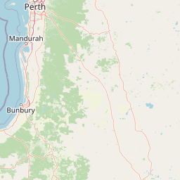
Map view of Helena National Park

Use this park location map to pinpoint Helena National Park in Australia, understand its exact geographic position, and read its mapped placement within the surrounding landscape more clearly.

Pigeon | © OpenStreetMap contributors

Location context for Helena National Park

City of KalamundaPerth metropolitan regionWestern AustraliaWheatbelt
Park atlas

Browse mapped protected landscapes and compare regional park geography across Western Australia.

Explore National Parks and Protected Areas Surrounding Helena National Park in Western Australia
After exploring Helena National Park, discover a curated list of nearby national parks and significant protected areas within Western Australia's Perth Hills and Jarrah Forest bioregion. Compare varied protected landscapes, trace shared regional geography, and identify distinct conservation areas across this unique part of Australia's southwest.
National parkPerth metropolitan region

Midgegooroo National Park: Jarrah Forest Protected Landscape and Regional Geography

Explore its mapped boundaries and terrain near Perth.

Midgegooroo National Park offers a distinct protected landscape characterized by its expansive jarrah forest terrain within the Perth metropolitan region. This national park provides valuable context for understanding regional geography, mapped natural features, and the distribution of protected lands. Explore the park's unique topography and conservation boundaries, vital for comprehensive atlas-based geographic discovery.

Area
24.92 km²
Established
2004
IUCN
II
Relief
Upland
National parkWheatbelt

Wandoo National Park National Park: Explore Protected Landscape and Geographic Boundaries

Discover Wheatbelt's mapped protected area.

Wandoo National Park is a designated national park situated in Australia's Wheatbelt region, offering a focal point for understanding protected landscapes. This page provides detailed geographic context for the park, highlighting its mapped boundaries and its significance within the broader regional geography. Users can explore the park's protected area status and its contribution to the mapped natural landscape of Western Australia, serving as a key entry point for atlas-based discovery.

Area
463.68 km²
Established
2004
IUCN
II
Climate
Temperate
National parkWestern Australia

Beelu National Park: Exploring Western Australia's Protected Jarrah-Marri Forest Landscape

Mapped Geographic Context & Natural Terrain Discovery

Beelu National Park, situated in Western Australia's Darling Range, offers an immersive experience within old-growth jarrah-marri forests. This protected area provides a vital glimpse into the region's natural landscapes, characterized by rolling hills and the Helena River valley. Users can explore the park's geographic setting, its mapped boundaries, and the unique ecological context it preserves. It stands as a significant natural reserve contributing to the understanding of Western Australia's conservation efforts and diverse terrain.

Area
46.17 km²
Established
1995
IUCN
II
Relief
Highland
National parkWestern Australia

Korung National Park: Protected Landscape and Map Context in Western Australia

Discover its unique dual bioregion geography.

Korung National Park is a protected national park in Western Australia, noted for its position along the Darling Scarp overlooking the Swan Coastal Plain. This reserve provides accessible natural experiences and showcases the ecological transition between two major southwest Australian bioregions. Its mapped landscapes offer a clear example of regional protected area planning and its importance for biodiversity conservation in the Perth metropolitan area.

Area
63.54 km²
Established
2004
IUCN
II
Relief
Mixed relief
Watercolor illustration of a landscape with rolling hills, trees, and fields
National parkWestern Australia

Kalamunda National Park: Explore Darling Scarp Woodland & Western Australia's Natural Terrain

A protected national park with distinct mapped landscape features.

Kalamunda National Park is an essential protected area located on the western slopes of the Darling Scarp, offering a clear representation of southwestern Australia's characteristic eucalypt woodland ecosystems. Its geography is defined by the escarpment's terrain, supporting tall marri, jarrah, and wandoo forests with a diverse understorey. As a national park, it provides critical habitat and contributes to the regional landscape context within Western Australia, making it a valuable point for atlas-driven discovery of protected natural areas.

Area
3.75 km²
Established
1964
IUCN
II
Relief
Mixed relief
National parkWestern Australia

Gooseberry Hill National Park: A Protected Landscape in Western Australia's Geography

Explore mapped boundaries and regional park context.

Gooseberry Hill National Park is a significant protected area designated as a national park within the diverse geography of Western Australia. This entry provides detailed insights into its specific location, mapped boundaries, and role as a conservation landscape. Understand how Gooseberry Hill National Park contributes to the broader atlas of protected lands in Western Australia, offering a foundational view for geographic exploration and landscape context.

Area
0.33 km²
Established
1970
IUCN
II
Relief
Highland
National parkWestern Australia

Greenmount National Park: Western Australia National Park Landscape and Geography Atlas

Explore its protected boundaries and regional landscape context.

Greenmount National Park represents a distinct protected landscape within the diverse geography of Western Australia. As a National Park, its mapped boundaries are integral to understanding its regional context and offering users a point of detailed geographic discovery. This entry provides essential data on its protected status and geographic setting, supporting exploration of Australia's significant natural areas through an atlas-driven lens.

Area
2.02 km²
Established
1970
IUCN
II
Relief
Upland
National parkWestern Australia

John Forrest National Park: National Park Atlas and Western Australia Protected Landscape

Mapped boundaries and regional geographic context.

Delve into the atlas-level details of John Forrest National Park, a protected area situated in Western Australia. This park's designation as a national park provides a focal point for understanding its specific geographic features and mapped extent. Users can explore its place within the broader regional geography of Western Australia, gaining structured insight into the protected landscape.

Area
26.78 km²
Established
1900
IUCN
II
Relief
Upland

Common questions about visiting, size, designation, and location context for Helena National Park

Helena National Park FAQs for park facts, access, geography, and protected area context
Find quick answers about Helena National Park, including protected-area facts, park geography, trail and visitor context, and how the park fits into its surrounding country and regional landscape.
MoriAtlas Explorer

Continue Your Protected Areas Search Across the Global Atlas

Deepen your exploration by continuing the structured search for national parks and protected areas worldwide. Utilize the comprehensive filtering capabilities to compare different conservation landscapes and refine your understanding of global park geography. Discover more about the distribution and characteristics of protected natural areas.

Global natural geography