Mori Atlas logo
National parkHornopirén National Park

Discover the geographic boundaries and protected landscape of this national park in Los Lagos Region.

Hornopirén National Park: Mapped Protected Area and Regional Landscape Identity

Hornopirén National Park represents a key protected area within the Los Lagos Region of southern Chile. This atlas-focused entry provides essential geographic context, detailing the park's mapped boundaries and its role as a national park preserving natural landscapes. Understanding Hornopirén National Park means exploring its unique position within the region's broader terrain and cataloging its protected-area significance for geographic discovery.

Temperate RainforestVolcanic LandscapeAncient ForestsGlacial LakesAndes MountainsPatagonia

Hornopirén National Park

National park

Park overview

Structured park overview, official facts, and landscape profile for Hornopirén National Park

Hornopirén National Park park facts, protected area profile, and essential visitor context
Review the core facts for Hornopirén National Park, including designation, size, terrain, visitor scale, habitats, and operating context in one park-focused overview.

About Hornopirén National Park

Hornopirén National Park represents one of the most significant protected areas in Chile's southern Andes, preserving a remarkable combination of volcanic geology, ancient forests, and glacial landscapes. The park's location in the Palena Province places it within a remote section of Patagonia that remains largely untouched by development. The Carretera Austral, Chile's famous southern highway, passes close to the park, providing access to this wilderness area while maintaining its ecological integrity. The park's boundary with Pumalín Park to the north creates a larger protected corridor that supports ecological connectivity across the region. Visitors to Hornopirén experience a landscape defined by dramatic elevation changes, from the volcanic summits down through forest-covered slopes to the lake-strewn valleys below. The combination of active volcanic activity, ancient forest preservation, and relatively low visitation makes this park distinctive among Chile's national park system.

Quick facts and research context for Hornopirén National Park

Located in the southern Chilean Andes, Hornopirén National Park was established in 1988 and is administered by CONAF. The park encompasses 482 km² of mountainous terrain with elevations ranging from the volcano peaks down to valley lakes. Key geographical features include the Yate volcano at 2,187 meters and the Hornopirén volcano at 1,572 meters, along with three main glacial lakes: Pinto Concha, Cabrera, and Inexplorado. The park contains 30 km² of glaciers and receives extremely high annual rainfall exceeding 2,500 mm. The alerce forests represent about 35% of the park's vegetation cover and are among the most significant remaining stands of this ancient conifer species.

Park context

Deeper park guide and search-rich context for Hornopirén National Park

Hornopirén National Park history, landscape, wildlife, and travel context
Explore Hornopirén National Park through its history, landscape character, ecosystems, wildlife, conservation priorities, cultural context, and seasonal travel timing in a structured park guide built for atlas discovery and search intent.

Why Hornopirén National Park stands out

Hornopirén National Park is best known for its exceptional ancient alerce forests, which contain Fitzroya trees among the oldest living organisms on Earth. The park's dramatic volcanic landscape features two prominent stratovolcanoes, Yate and Hornopirén, set within a landscape of glacial valleys and crystalline lakes. The turquoise-colored lakes, particularly Pinto Concha, are striking visual features created by glacial rock flour. The park also protects significant populations of threatened species including the Chilean huemul and cougar, making it an important conservation area for Patagonian biodiversity.

Hornopirén National Park history and protected-area timeline

Hornopirén National Park was established in 1988 as part of Chile's expansion of its protected area network in the southern regions. The creation of the park reflected growing recognition of the international significance of the temperate rainforests of southern Chile and the need to preserve the ancient alerce ecosystems. The park was designated under the Chilean national park system and placed under the administration of the Corporación Nacional Forestal (CONAF). Prior to its protection, the region had experienced limited human activity due to its remote location and difficult terrain, which contributed to the preservation of its natural state. The establishment of the park also coincided with broader conservation efforts in Chilean Patagonia, including the creation of adjacent protected areas that now form a contiguous conservation landscape.

Hornopirén National Park landscape and geographic character

The landscape of Hornopirén National Park is defined by its location within the Andes mountain chain, featuring rugged terrain shaped by glacial processes and volcanic activity. The park contains prominent volcanic peaks including Yate volcano at 2,187 meters above sea level and Hornopirén volcano at 1,572 meters, both of which are active stratovolcanoes that contribute to the dramatic skyline. Extensive glaciation has carved deep valleys and created a landscape of steep ridges and U-shaped valleys. The park encompasses approximately 30 square kilometers of glaciers, remnants of the ice ages that shaped much of the southern Andes. Three primary lakes dot the landscape: Pinto Concha at 4.75 km², Cabrera at 1.55 km², and Inexplorado at 1.5 km², each displaying characteristic blue and green hues derived from rock flour suspended in their waters. The Blanco River drainage system, including the paternoster lake chain feeding into Inexplorado Lake, forms a significant hydrological feature, while the Negro River represents another major watercourse traversing the park.

Hornopirén National Park ecosystems, habitats, and plant life

The natural environment of Hornopirén National Park is characterized by the presence of the globally significant Austral or Valdivian temperate rain forest ecosystem. The most notable feature is the extensive alerce (Fitzroya cupressoides) forest, which represents one of the largest remaining stands of this ancient conifer species. These millennial alerce forests cover approximately 97.41 square kilometers, comprising roughly 35 percent of the park's vegetation cover and occurring in nearly pure stands in some areas. The alerce is recognized as the second oldest tree species on Earth, with individuals living over 5,000 years. The forest ecosystem surrounding the alerce contains a complex structure of other native species adapted to the cool, wet conditions of the southern Andes. The high rainfall, averaging 2,500 mm annually and exceeding 4,000 mm in some years, supports this lush forest environment.

Hornopirén National Park wildlife and species highlights

Hornopirén National Park supports approximately 25 mammal species, representing a mix of native Chilean fauna and introduced species. The park is home to several notable native mammals including the Chilean huemul (Hippocamelus bisulcus), a threatened deer species that is a symbol of Chilean Patagonia and receives special conservation attention. The kodkod (Leopardus guigna), South America's smallest cat, inhabits the forest understory, while the cougar (Puma concolor) occupies the role of apex predator. Other native species include the lesser grison, chilla fox (South American gray fox), and the pudú, one of the world's smallest deer species. Introduced species such as American mink and coypu also occur in the park. Of particular conservation significance, the park supports 18 threatened species, highlighting its importance as a biodiversity refuge in the southern Andes.

Hornopirén National Park conservation status and protection priorities

Hornopirén National Park plays a critical role in the conservation of Chile's temperate forest biome and its unique biodiversity. The protection of the ancient alerce forests is particularly significant given that Fitzroya represents one of the world's oldest and rarest tree species, and Chile has lost substantial portions of its old-growth forests to logging and development. The park's designation as an IUCN Category II protected area reflects its primary mandate of preserving natural ecosystems while allowing for sustainable visitation. The presence of 18 threatened species within the park, including the endangered Chilean huemul, underscores its ecological importance. The park's location adjacent to Pumalín Park creates a larger conservation complex that supports ecological corridors and protects continuous habitat across a significant landscape. The extreme rainfall and difficult access have historically limited human impact, preserving much of the area in a relatively pristine state.

Hornopirén National Park cultural meaning and human context

Hornopirén National Park is situated in the Los Lagos Region, an area historically associated with Chilote and Patagonian indigenous communities. The park takes its name from the nearby town of Hornopirén and the Hornopirén volcano, with the name deriving from Mapudungun origins reflecting the region's linguistic heritage. The landscape has been traditionally used by local communities for subsistence activities including fishing and limited agriculture. The establishment of the Carretera Austral has increased regional accessibility while introducing new pressures and opportunities for the region. The nearest population center, the town of Hornopirén, serves as the gateway for park visitors and the administrative location for CONAF operations. The area remains sparsely populated, with much of the surrounding land in private hands, and the park represents one of the few formally protected wilderness areas in this part of Chilean Patagonia.

Top sights and standout views in Hornopirén National Park

The defining highlights of Hornopirén National Park include the ancient alerce forests with their millennia-old Fitzroya trees, the dramatic volcanic peaks of Yate and Hornopirén, and the striking glacial lakes with their distinctive turquoise coloring. The park offers a remote wilderness experience with limited infrastructure, requiring visitors to traverse gravel roads and, in some areas, hike on foot to access the backcountry. The closure of the park during winter months (July to November) due to heavy snowfall creates a distinct seasonal visitation window. The free entrance and lack of developed visitor services contribute to a backcountry experience quite different from more heavily visited Chilean national parks. The proximity to the Carretera Austral makes this park accessible to those traveling the iconic Patagonian highway while offering a more rugged alternative to more developed destinations.

Best time to visit Hornopirén National Park

The optimal time to visit Hornopirén National Park runs from December through June, as the park closes to the public between July and November due to heavy snow and ice accumulation exceeding one meter in the recreation area. The summer months of December through February offer the most reliable access and mildest conditions, though even during this period rainfall remains high and temperatures stay cool, ranging between 9 and 12 degrees Celsius. Visitors should be prepared for the challenging weather conditions that characterize this section of the Andes, where annual rainfall frequently exceeds 2,500 mm and can surpass 4,000 mm in wet years. The winter closure period reflects the severity of conditions in this high-rainfall, high-elevation Patagonian environment and visitors planning trips should verify current access conditions before traveling to this remote area.
Park location guide

Geography guide, regional context, and park location map for Hornopirén National Park

Hornopirén National Park park geography, regions, and map view in Chile
Understand where Hornopirén National Park sits in Chile through a broader geographic reading of the surrounding landscape, nearby location context, and its mapped position within the national park landscape.

How Hornopirén National Park fits into Chile

Chile is a presidential republic in western South America, extending as a narrow strip along the western edge of the continent between the Andes Mountains and the Pacific Ocean. It is the southernmost country in the world and the closest to Antarctica. The country is bordered by Peru, Bolivia, and Argentina, and administers several Pacific islands including Easter Island. Chile is a major copper producer and has a population of approximately 19.6 million.

Wider geography shaping Hornopirén National Park in Chile

Chile occupies a narrow strip of land along the western edge of South America, extending approximately 4,300 km north to south but only about 350 km east to west at its widest point. The country is sandwiched between the Andes Mountains to the east and the Pacific Ocean to the west. It shares borders with Peru to the north, Bolivia to the northeast, and Argentina to the east. Southern Chile borders the Drake Passage. Chile also administers several Pacific islands including Juan Fernández Islands, Isla Salas y Gómez, Desventuradas Islands, and Easter Island, plus the Chilean Antarctic Territory.

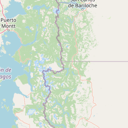
Map view of Hornopirén National Park

Use this park location map to pinpoint Hornopirén National Park in Chile, understand its exact geographic position, and read its mapped placement within the surrounding landscape more clearly.

Pigeon | © OpenStreetMap contributors

Location context for Hornopirén National Park

Los Lagos RegionPalena Province
Park atlas

Explore adjacent protected areas, trace the Andes mountain chain, and compare conservation landscapes across Chile's Los Lagos Region.

Discover Other National Parks Near Hornopirén National Park and Its Patagonian Wilderness
After exploring Hornopirén National Park's ancient alerce forests and volcanic peaks, browse a curated selection of nearby national parks and protected areas that share its dramatic Patagonian landscape. Use this geographic context to compare diverse Andean terrain, discover connected protected-area systems, and understand the regional spread of Chile's unique conservation efforts.
National parkLos Lagos Region

Alerce Andino National Park: Protected Landscape Within Los Lagos Region Geography

Explore the national park's mapped boundaries and regional context.

Delve into the protected landscape of Alerce Andino National Park, a distinct national park entity situated in Chile's Los Lagos Region. This focus provides a clear understanding of its geographic setting, highlighting its importance within regional conservation efforts and offering a detailed view of its mapped terrain. Understand the park's place in the southern Chile geography through this detailed exploration.

Area
393 km²
Established
1982
IUCN
II
Visitors
12.2K annual
Watercolor illustration showing a lake surrounded by forested hills and mountains
National parkChubut Province

Lago Puelo National Park: A Unique Protected Landscape at the Intersection of Biomes

Explore its glacial terrain and Andean-Patagonian geographic context.

Lago Puelo National Park, located in Argentina's Chubut Province, stands out as a significant protected area due to its remarkable ecological diversity. This park is distinguished by its rare transition zone where the Patagonian forest converges with the Andean steppe, incorporating flora typically found in the Valdivian temperate rainforest. The mountainous landscape, carved by glaciers, features the striking turquoise waters of Puelo Lake and surrounding river systems. Understanding Lago Puelo National Park's geography provides insight into the complex natural systems of Patagonia and its unique protected biomes.

Area
276.74 km²
Established
1971
IUCN
II
Relief
Mountain
National parkLos Lagos Region

Vicente Pérez Rosales National Park: Protected Landscape & Regional Geography Atlas

Mapped park boundaries and natural terrain in Los Lagos Region.

Delve into the protected area identity of Vicente Pérez Rosales National Park, a significant national park situated in Chile's Los Lagos Region. This detailed exploration focuses on understanding the park's geographic setting, its mapped landscape features, and its contribution to the regional atlas of protected territories. Discover the natural terrain and boundary context that define this unique Chilean landscape.

Area
2,530 km²
Established
1926
IUCN
II
Visitors
332.3K annual
Watercolor painting depicting mountains, a lake, and grassy shoreline
National parkArgentina

Los Alerces National Park: Ancient Alerce Forests and Glacial Terrain in Argentina

Discover the park's protected landscape and regional geography.

Los Alerces National Park in Argentina is a globally significant protected area, celebrated for its ancient alerce forests, some of the longest-living trees on Earth. This national park showcases a dramatic landscape shaped by glaciers, featuring a series of interconnected lakes and rugged Andean terrain. Explore the unique ecosystem and mapped geography of this UNESCO World Heritage site to understand its profound natural and conservation value.

Area
2,599 km²
Established
1937
IUCN
II
Relief
Mountain
National parkRío Negro Province

Nahuel Huapi National Park: Protected Area Landscape and Geographic Context in Río Negro

Explore mapped natural terrain and park boundaries within Patagonia.

Nahuel Huapi National Park is a crucial protected area offering a deep dive into the Patagonian landscape. Situated in Argentina's Río Negro Province, this national park provides a detailed view of mapped natural terrain and its environmental context. Users can explore the park's geographic identity and protected boundaries, making it an essential stop for understanding the regional geography and conservation significance of this part of South America.

Area
7,050 km²
Established
1934
IUCN
II
Relief
Mountain
National parkNeuquén Province

Los Arrayanes National Park: Neuquén Province's Protected Arrayán Forest Atlas

Explore the ancient arrayán forest and mapped terrain.

Los Arrayanes National Park, nestled in Neuquén Province, is celebrated for its exceptional arrayán forest, one of the world's most concentrated stands of Luma apiculata. This protected area showcases a unique landscape where ancient, gnarled trees with striking cinnamon bark thrive on the Quetrihué Peninsula, overlooking Nahuel Huapi Lake. Its protected status ensures the preservation of this botanical marvel, offering a distinct geographical and ecological profile within the Patagonian region.

Area
17.53 km²
Established
1971
IUCN
II
Relief
Upland
Watercolor illustration of a mountain range with a lake and forested hills in soft green, pink, and beige tones
National parkLos Lagos Region

Puyehue National Park: Mapped Boundaries and Volcanic Landscape in Los Lagos Region

Explore Chile's dramatic Andean protected area.

Puyehue National Park is a key protected area in the Los Lagos Region of Chile, recognized for its distinctive volcanic landscapes and geothermal features. This detail page offers an atlas-centric view, highlighting the park's mapped boundaries, the terrain shaped by volcanoes like Puyehue, and its ancient temperate rainforest ecosystems. Understand its geographic context within the Andes and its significance as a protected national park.

Area
1,070 km²
Established
1941
IUCN
II
Visitors
133K annual
National parkLos Lagos Region

Chiloé National Park: National Park Discovery and Mapped Boundaries in Los Lagos Region

Explore its unique protected landscape and regional geography.

Chiloé National Park represents a significant protected natural area within the Los Lagos Region of Chile. This detailed page offers an atlas-centric view, focusing on the park's mapped boundaries, its place in the regional geography, and the overall protected landscape character. Gain structured insight into this important component of southern Chile's conservation lands, ideal for geographic exploration and atlas context.

Area
430.57 km²
Established
1983
IUCN
II
Visitors
33.6K annual

Common questions about visiting, size, designation, and location context for Hornopirén National Park

Hornopirén National Park FAQs for park facts, access, geography, and protected area context
Find quick answers about Hornopirén National Park, including protected-area facts, park geography, trail and visitor context, and how the park fits into its surrounding country and regional landscape.
MoriAtlas Explorer

Continue Your Protected Areas Search Across the Global Atlas

Deepen your exploration by continuing the structured search for national parks and protected areas worldwide. Utilize the comprehensive filtering capabilities to compare different conservation landscapes and refine your understanding of global park geography. Discover more about the distribution and characteristics of protected natural areas.

Global natural geography