
Ponds
Park geography
Detailed spatial analysis covering boundary dimensions, local terrain, and landscape features
Comprehensive Geographic Profile of İğneada Floodplain Forests National Park in Turkey
This geographic profile provides an in-depth look at the spatial characteristics of İğneada Floodplain Forests National Park in Kırklareli Province. Discover precise boundary measurements, local lowland terrain, and the diverse aquatic and forest ecosystems contained within these protected lands.

Rare coastal floodplain ecosystem with wetlands, dunes and ancient forests on Turkey's Black Sea border
İğneada Floodplain Forests National Park
İğneada Floodplain Forests National Park is a distinctive protected area in the European part of Turkey, located in Kırklareli Province along the Turkish-Bulgarian border near the Black Sea coast. Established in November 2007, the park protects one of Turkey's rare and ecologically significant floodplain ecosystems, where streams descending from the Strandzha mountain range have deposited alluvium over centuries, creating a complex landscape of marshes, swamps, lakes, and coastal sand dunes. The park encompasses approximately 3,155 hectares and represents a rare example of a Mediterranean-influenced wetland system in northwestern Turkey. Its location at the crossroads of European and Asian ecological zones gives the park exceptional biodiversity value, with habitats ranging from freshwater lakes and lagoons to ancient deciduous forests and vulnerable coastal dune systems.
- Location
- Turkey
- Park type
- National park
- Established
- 2007
- Area
- 31.6 km²
Location overview
Regional and coastal positioning within Turkey's Kırklareli Province
Geographic Location of İğneada Floodplain Forests National Park
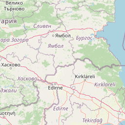
Located in Turkey, İğneada Floodplain Forests National Park is situated within the Kırklareli Province. As a coastal protected area, the park operates under national jurisdiction with no transboundary borders.
- Countries
- Turkey
- Regions
- Kırklareli Province
- Primary location
- Kırklareli Province
- Geographic setting
- Coastal
Boundary and coordinates
Charting the spatial coordinates and 31.55 square kilometer total area
Geographic Boundary Map of İğneada Floodplain Forests National Park
Interactive boundary geometry outlines the spatial limits of the protected reserve. Accompanying dataset metrics detail the calculated 31.55 square kilometer area, central coordinates, and regional geographic span.
- Boundary area
- 34.5 km²
- Boundary perimeter
- 62.2 km
- Northernmost point
- 41.9148° N
- Southernmost point
- 41.7707° N
- Easternmost point
- 28.0185° E
- Westernmost point
- 27.9184° E
- Geographic centre
- 41.842° N, 27.9656° E
- North–south span
- 16 km
- East–west span
- 8.3 km
Terrain and natural features
Explore recorded lowland terrain classifications and mapped natural features
İğneada Floodplain Forests National Park Terrain and Named Features
Stored regional classifications identify lowland terrain profiles alongside recorded streams, lakes, ponds, and peaks. Mapped feature cards supply specific names, types, and spatial relationships across the landscape.
Selected named natural features
Peaks
Yayvan Tepe
Streams
Palabıyık Deresi
Natural springs
Kurt Pınarı
Streams
Bezirgan Dere
Streams
Dere
Environmental setting
Temperate lowland forest, wetland, and coastal water systems
İğneada Floodplain Forests National Park Environmental Classifications
Recorded landscape features and habitat types frame the physical setting through broad interpretive categories. Stored classifications connect recorded terrain data directly to relevant atlas destinations.
- Relief
- Lowland
- Climate
- Temperate
- Water
- Major water bodies
- Forest cover
- Mostly forested
- Seasonality
- Seasonal
Landscape features
Forest · Wetland · Lakes · Dunes · Beach · Coast
Habitat types
Temperate broadleaf forest · Wetland · Riverine habitat · Lacustrine habitat · Coastal habitat · Dune habitat
Park atlas
Compare İğneada's unique floodplain ecosystem with other protected areas across Kırklareli Province and the wider Black Sea region.
Continue Park Discovery: Find Other Protected Areas Near İğneada Floodplain Forests National Park
Explore other protected areas, including national parks and reserves, near İğneada Floodplain Forests National Park across Turkey's Kırklareli Province and adjacent Black Sea regions. Compare varied conservation landscapes, tracing the geographic spread of distinct wetlands, coastal dunes, and diverse forested ecosystems within this ecologically significant territory.
National parkEastern Macedonia and Thrace
About 162 km away#1 closest
Southwest

Dadia-Lefkimi-Soufli Forest National Park: Protected Landscape Atlas and Raptor Habitat
Mapped terrain and protected area context in Eastern Macedonia and Thrace.
This canonical entry for Dadia-Lefkimi-Soufli Forest National Park provides a structured atlas view of its protected landscape. Understand the park's geographic setting within Eastern Macedonia and Thrace, its mapped boundaries, and its significance as a critical sanctuary for raptors across Europe. Explore the diverse natural terrain that defines this protected area and its ecological importance.
- Area
- 428 km²
- Established
- 2006
- IUCN
- VI
- Visitors
- 50K annual
National parkBalıkesir Province
168 km away#2 closest
South

Kuşcenneti National Park: Mapping Turkey's Premier Bird Sanctuary and Wetland Ecosystem
Explore the protected boundaries and avian geography of this key national park.
Kuşcenneti National Park stands as Turkey's foundational protected area for bird conservation, celebrated for its critical role as an avian migration crossroads and nesting ground. Situated in Balıkesir Province, this national park encompasses a diverse wetland ecosystem including shallow lakes, flooded willow forests, and extensive marshlands. MoriAtlas provides a detailed geographic context for Kuşcenneti National Park, highlighting its mapped protected area, unique landscape features, and profound significance for regional avian biodiversity.
- Area
- 240.47 km²
- Established
- 1959
- IUCN
- II
- Visitors
- 2.5M annual
National parkTurkey
About 187 km away#3 closest
Southwest
Lake Gala National Park: A Key Protected Wetland Landscape in Turkey's Maritsa Delta
Discover its bird habitats and mapped geographic context.
Lake Gala National Park is a nationally significant protected area, designated in 2005 to conserve the unique wetland ecosystem of the Maritsa Delta. Encompassing the shallow lakes Pamuklu and Küçük Gala, this park spans approximately 6,090 hectares of diverse wetland and forest habitats. It is internationally recognized as a Ramsar site and serves as a critical sanctuary for over 160 bird species, making it a premier birdwatching destination in Turkey and an important locus for understanding protected landscapes within a regional geographic framework.
- Area
- 60.9 km²
- Established
- 2005
- IUCN
- II
- Relief
- Lowland

National parkTurkey
About 211 km away#4 closest
Southeast
Uludağ National Park: Turkey's Oldest National Park's Alpine Landscape and Geography
Mapped protected area in Turkey's Marmara region.
Delve into the protected landscape of Uludağ National Park, Turkey's first national park, renowned for its distinctive alpine environment and dramatic mountain terrain. This page offers a detailed atlas view of the park's geography, mapped boundaries, and unique ecosystems, providing essential context for understanding this significant protected area within Turkey's natural heritage.
- Established
- 1961
- IUCN
- II
- Relief
- Mountain
- Climate
- Temperate
National parkLovech Province
243 km away#5 closest
West

Central Balkan National Park: Bulgaria's Majestic National Park and Protected Landscape
Explore mapped alpine terrain and ancient forests in Lovech Province.
Central Balkan National Park is a significant protected area in Bulgaria, renowned for its stunning mountain geography and exceptionally well-preserved ancient beech forests. Located within Lovech Province, the park's landscape is defined by dramatic peaks, including Botev Peak, deep canyons, and alpine meadows, offering a rich context for geographical exploration and understanding its protected status. Its ecosystem health and ecological value are underscored by multiple nature reserves and its recognition as part of a UNESCO World Heritage Site.
- Area
- 716.69 km²
- Established
- 1991
- IUCN
- II
- Relief
- Mountain

Protected areaTurkey
About 250 km away#6 closest
Southwest
Ancient Troya National Park: A Mapped Protected Landscape with Deep Historical Significance
Explore the terrain and protected boundaries of this key Turkish heritage site.
Ancient Troya National Park offers a unique window into history, preserving the layers of the ancient city of Troy within its protected boundaries. Situated in Turkey, this park encompasses a significant archaeological site on a commanding hilltop, overlooking rolling Mediterranean terrain and coastal plains. Its landscape, characterized by fortified walls, gates, and the remnants of ancient structures, provides a rich context for understanding its mythological and historical importance. MoriAtlas provides detailed mapping and geographic context for this vital protected area, enhancing its atlas exploration value.
- Established
- 1996
- IUCN
- II
- Relief
- Lowland
- Climate
- Mediterranean

National parkTurkey
About 251 km away#7 closest
South
Kazdağı National Park: Explore Turkey's Protected Mountainous Terrain and Forest Ecosystem
Mapped geography and protected landscape context within Turkey's Aegean region.
Kazdağı National Park is a significant protected area in Turkey, renowned for its dramatic mountain landscape encompassing Mount Ida. This park safeguards a critical subalpine forest ecosystem, characterized by diverse tree species that transition into rocky summits and alpine meadows. Understanding Kazdağı National Park's mapped boundaries provides essential insight into the regional geography, watershed protection, and the unique natural terrain found in western Turkey's Mediterranean mountain ranges, offering a solid foundation for geographic discovery.
- IUCN
- II
- Scope
- Terrestrial
National parkEastern Macedonia and Thrace
About 252 km away#8 closest
West
Parc national de Macédoine-Orientale-et-Thrace: Wetland Atlas and Geographic Boundaries
Coastal lagoons and river delta protected landscapes
Gain insight into the ecological and geographic structure of Parc national de Macédoine-Orientale-et-Thrace. This protected area encompasses a complex mosaic of river deltas, shifting saline lagoons, and remnant riparian forests that anchor the natural landscape of Eastern Macedonia and Thrace.
- Area
- 929.47 km²
- Established
- 2008
- IUCN
- V
- Relief
- Lowland
MoriAtlas Explorer
Continue Atlas Exploration of İğneada Floodplain Forests National Park's Landscape
Delve deeper into the geographic intricacies and protected area context of İğneada Floodplain Forests National Park. Understanding this unique floodplain ecosystem, its mapped boundaries, and its position within Kırklareli Province provides valuable insight for structured landscape discovery. MoriAtlas facilitates this exploration by offering detailed geographic data and regional context, allowing for a comprehensive view of Turkey's natural protected zones and their mapped terrain.
Browse next
Global natural geography
Explore related park routes
Explore MoriAtlas Global ParksBrowse All MoriAtlas ParksGlobal Park Map DiscoveryMoriAtlas: Browse All CountriesBrowse All MoriAtlas ContinentsNational Park Environment AtlasGrand Canyon National Park AtlasYellowstone National Park AtlasYosemite National Park Atlas and GeographySerengeti National Park AtlasGalápagos National Park Protected LandscapeBanff National Park Geography and AtlasKruger National Park Atlas EntryUluṟu-Kata Tjuṯa National Park AtlasExplore Uluru-Kata Tjuta National Park GeographyPlitvice Lakes National Park AtlasFiordland National Park Protected LandscapeGreat Smoky Mountains National Park AtlasAfghanistan National Parks and Protected AreasAlbania National Parks and Protected AreasAlgeria National Parks and Protected AreasAmerican Samoa National Parks and Protected AreasAndorra National Parks and Protected AreasAngola National Parks and Protected AreasAntarctica National Parks and Protected AreasAntigua and Barbuda Park List