
Mori Atlas logo
Protected areaÎle Plate

A low lying volcanic and limestone sanctuary defining the northern Mauritian lagoon

Île Plate: Mapping the Geography and Protected Landscapes of this Mauritian Island

Île Plate functions as a protected area located within the Rivière du Rempart District, representing a distinct geographic formation in the Indian Ocean. This island is characterized by its tabletop profile, luminous white limestone beaches, and dark volcanic rock formations. Beyond its physical terrain, the site preserves 19th century quarantine infrastructure and serves as a vital habitat for endemic flora and the critically endangered Bojer's skink.

uninhabited islandIndian OceanMauritiusprotected areaseabird nestingnative flora
A minimalist, flat vector illustration showing a colorful island scene with a waterfall, forest, and surrounding water.

Île Plate

Protected area

Park overview

Structured park overview, official facts, and landscape profile for Île Plate

Île Plate park facts, protected area profile, and essential visitor context

Review the core facts for Île Plate, including designation, size, terrain, visitor scale, habitats, and operating context in one park-focused overview.

About Île Plate

Île Plate, also known as Flat Island, is a small island in the Indian Ocean positioned off the northern coast of Mauritius. Although small, covering only about 2.5 square kilometres, it plays an outsized role in Mauritius's network of protected areas because it is uninhabited, ecologically rich, and carries a well-preserved 19th-century quarantine landscape. Together with the neighbouring Îlot Gabriel and the Pigeon Rock outcrop, it forms a trio of national protected areas in the waters just north of the main island.

The island's physical character is unusually flat, apart from a bluff near its interior, and most of its coastline consists of low rock and a striking white limestone beach that contrasts with darker reddish and black rock outcrops. The 19th-century French naturalist Jean-Baptiste Bory de Saint-Vincent, who approached it during the Baudin expedition to Australia in March 1801, described exactly this contrast and suggested that the darker rocks were the remains of an ancient volcanic crater. While modern interpretations focus more on limestone and basalt formations, the image of a vivid white shoreline framed by dark rock remains central to the island's identity.

Beyond its physical setting, Île Plate has been shaped by a mixture of conservation attention and human use. The island served as a quarantine station from the mid-19th century through the 1930s, when it processed waves of indentured labourers and other immigrants during outbreaks of cholera, smallpox, and malaria. The stone and wooden buildings erected between 1856 and 1870, along with two hospitals, kitchens, barracks, a cemetery with basalt cairns, and an old distillation plant for water, are still partly visible beneath the vegetation. Today, the island balances this layered cultural heritage with modern biodiversity goals, including seabird protection, vegetation surveys by the University of Mauritius, and active management of invasive mammals that have threatened native wildlife such as Bojer's skink.

Quick facts and research context for Île Plate

Île Plate is a small, largely uninhabited island located in the Indian Ocean roughly 11 kilometres north of Cap Malheureux, the northernmost point of Mauritius. It covers a total area of about 2.5 square kilometres, is roughly circular in outline, and sits within the Rivière du Rempart District of Mauritius. Two associated islets, Îlot Gabriel and Pigeon Rock, lie close to its shore and, together with Île Plate, form part of Mauritius's system of national protected areas.

The island is very low-lying apart from a single bluff, and its profile is dominated by a striking white limestone beach combined with reddish and dark-coloured rocks that early European visitors interpreted as evidence of ancient volcanic activity. A lighthouse built in 1855 still operates on its southwestern side, and a small army base is the only ongoing human installation on an otherwise uninhabited landmass.

Protection and recognition

Analysis of management scope, designation history, and recognition sources

Île Plate Protection Status and Documented Conservation Frameworks

Examine the documented protection status and mixed conservation framework assigned to Île Plate. Review official management parameters and associated data records compiled within the protected area inventory.

Protection details

Protection scope
Mixed
Park context

Deeper park guide and search-rich context for Île Plate

Île Plate history, landscape, wildlife, and travel context

Explore Île Plate through its history, landscape character, ecosystems, wildlife, conservation priorities, cultural context, and seasonal travel timing in a structured park guide built for atlas discovery and search intent.

Why Île Plate stands out

Île Plate is best known as a low-lying, ecologically significant island directly north of Mauritius, recognised for its protected-area status, its remaining 19th-century quarantine infrastructure, and its biodiversity, including seabird colonies, indigenous plants, and a surviving population of the critically endangered Bojer's skink. It is also closely associated with the nearby Pigeon Rock dive site known internationally as The Shark Pit. The island's appeal blends natural and cultural dimensions. Its white limestone beach, dark volcanic rocks, bluff, interior wetlands, and surrounding islets create a distinctive Mascarene landscape, while its stone buildings, hospitals, and cemetery preserve a tangible record of Mauritius's immigration and public health history. Visitors value it both as a wildlife-rich uninhabited island and as a heritage site shaped by the indentured labour experience.
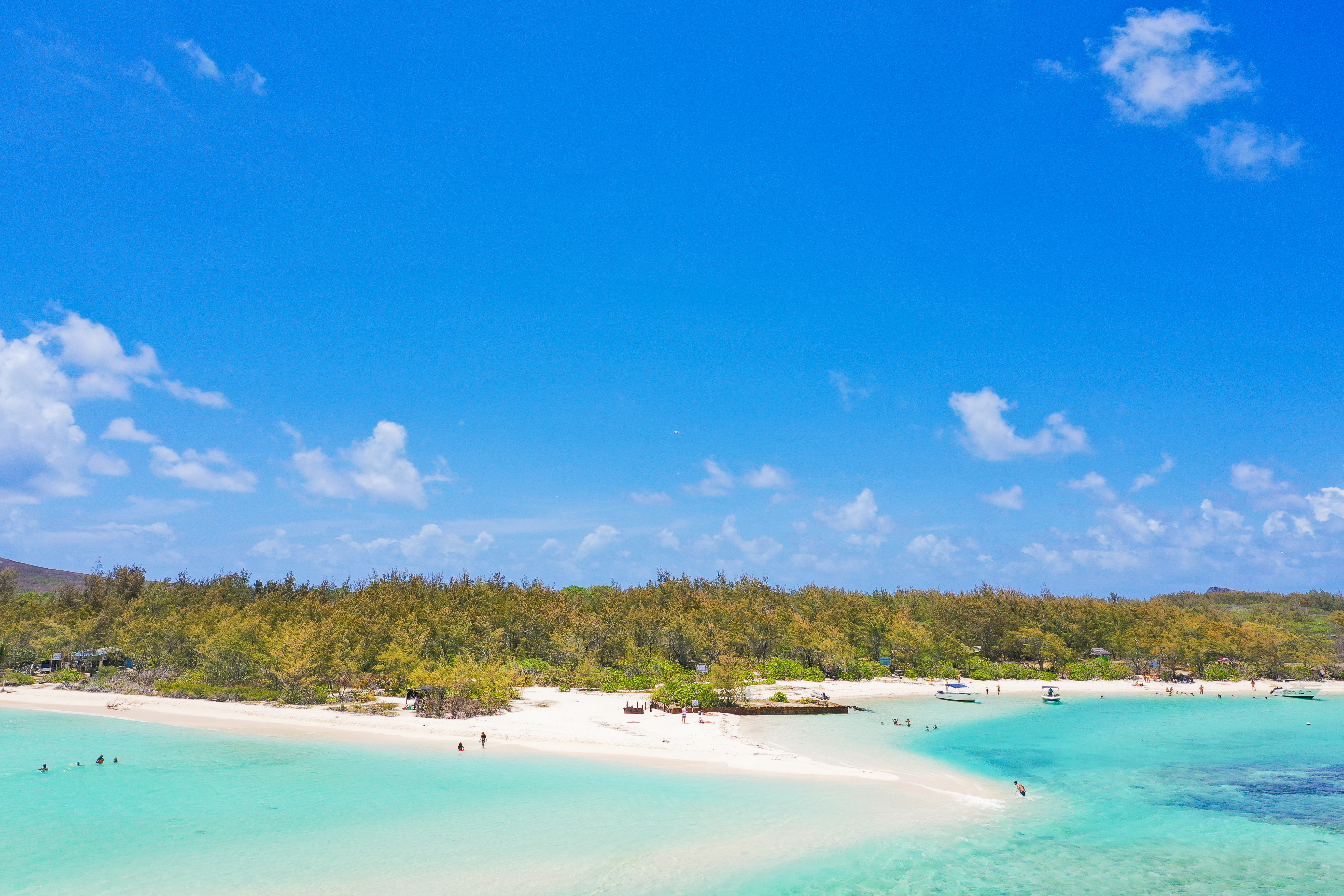
A wide aerial view showing a white sandy beach curving into shallow, bright turquoise ocean water on Ile Plate, with low-lying green vegetation and a clear blue sky in the background.
A scenic view of the white sandy beach and turquoise waters at Ile Plate.

Île Plate history and protected-area timeline

Île Plate has a layered human history that begins with exploration and ends with heritage protection. On 15 March 1801, during the Baudin expedition to Australia, the French corvette Naturaliste approached the island. The expedition's naturalist, Jean-Baptiste Bory de Saint-Vincent, recorded the island's defining visual feature: a dazzling white limestone beach in contrast with reddish and black rocks, reportedly explained to him by an engineer officer named Lilet as the remains of an ancient volcanic crater.

In 1855, one of the few still-operating lighthouses in Mauritius was built on the southwest coast of the island, anchoring the island's presence in the country's maritime infrastructure. Soon after, starting in the mid-19th century, Île Plate was repurposed as a quarantine station, initially for cholera and later for smallpox and malaria outbreaks. The station was reserved primarily for incoming immigrants, especially indentured labourers arriving in Mauritius. Between 1856 and 1870, an extensive set of buildings was constructed, including stone and wooden accommodation for medical, police, and immigration officials; barracks for quarantined migrants; kitchens; stores; toilets; privies; two hospitals; and a distillation plant for water supply. The island continued to function as a quarantine facility until the 1930s, after which the infrastructure was gradually abandoned and reclaimed by vegetation.

The cemetery on the southern side of the island marks the human cost of this period, with graves still recognisable by their basalt structures and cairns. Since 2014, Stanford University's Project MACH (Mauritian Archaeology and Cultural Heritage) has worked alongside the Aapravasi Ghat Trust Fund and National Parks and Conservation Services of Mauritius to assess the site. Four archaeological campaigns have included intensive surveys and test-pits around the provisioning store, one of the hospitals, and one of the immigrant camps, alongside plans for geophysical surveys, environmental sampling, and drone-based mapping, all feeding into a wider restoration and conservation plan.

Île Plate landscape and geographic character

Île Plate's landscape is unusual for the Mascarene region because it is exceptionally low-lying and flat, almost tabletop in profile apart from a single bluff near the interior. The island spans about 2.5 square kilometres and is roughly equal in length and width, only about 1.9 kilometres across, giving it the compact, rounded silhouette that has earned it its name. Its outermost feature is a luminous white limestone beach, long noted by passing mariners, which is the dominant visual element when approaching the island from the sea.

Behind the beach, the geology shifts. The rest of the shoreline and interior exposure consists of reddish and dark-coloured rocks that early observers interpreted as the debris of an ancient volcanic crater. Modern understanding emphasises basalt and weathered volcanic formations, while the bluff provides the island's only significant elevation, reaching just a few dozen metres at its highest point. Inland, the terrain softens into vegetated lowlands and pockets of wetland that help shape the island's ecological character.

The surrounding seascape is just as important as the island itself. Two small islets, Îlot Gabriel and Pigeon Rock, lie very close to the shore and effectively extend the island's visual presence; Pigeon Rock is part of the broader Islets National Park, and together the three sites function as a single protected landscape system. Views across the water from Île Plate to these islets, and from the islets back toward Île Plate, define much of the experience of moving through this part of the northern Mauritian lagoon.

Île Plate ecosystems, habitats, and plant life

Île Plate's ecological identity combines low-lying Mascarene island vegetation, pockets of wetland, and persistent exposure to invasive species. A vascular plant census carried out in 2007/2008 by the University of Mauritius recorded 121 species on the island, a substantial share of which are non-native. Despite this, the island still supports a notable set of indigenous plants, including the Latania loddigesii palm, the Pandanus vandermeeschii screwpine, and Psiadia arguta, alongside reintroduced species such as Dracaena concinna and Aloe tormentorii, which were brought over from neighbouring Coin de Mire to reinforce the native flora.

The interior vegetation is unusually rich for such a small, flat island, and its combination with seasonal wetlands creates habitat diversity rarely seen this far out to sea in the Mascarenes. The mix of dry coastal limestone scrub, denser interior thickets, and damp low-lying pockets supports both resident wildlife and seasonal visitors. Vegetation cover also softens the island's quarantine-era ruins, gradually integrating the abandoned buildings back into the natural landscape.

The island's ecology is, however, constantly under pressure from invasive species. Black rats, which once plagued the island, were eradicated from Gabriel and Flat Islands in 1995 and 1998 respectively, marking a successful intervention that allowed native flora and fauna to recover. The continued presence of exotic plants, exotic geckos, and the fossorial snake Indotyphlops braminus keeps management active, while introduced shrews have had severe impacts on native reptiles, especially Bojer's skink. As global sea levels rise, the island's low topography also raises concerns about the future of its freshwater pockets and vegetation zones.

Île Plate wildlife and species highlights

Île Plate's wildlife is shaped by its isolation and its position as a stepping-stone between the Mauritian mainland, Coin de Mire, and the smaller islets of Îlot Gabriel and Pigeon Rock. With no native terrestrial mammals other than bats, the island's mammal fauna consists of three bat species: the Mauritian flying fox (Pteropus niger), the Mauritius tomb bat (Taphozous mauritianus), and the Natal free-tailed bat (Mormopterus acetabulosus).

The island is particularly important for its birdlife. Three seabird species actively nest on Île Plate: the Wedge-tailed shearwater (Ardenna pacifica), the Red-tailed Tropicbird (Phaethon rubricauda), and the White-tailed Tropicbird (Phaethon lepturus). The richer interior vegetation, combined with the presence of small wetlands, also supports the striated heron (Butorides striata), while occasional visitors such as the Whimbrel (Numenius phaeopus), Grey Plover (Pluvialis squatarola), and Ruddy Turnstone (Arenaria interpres) turn the island into a broader shorebird site. Introduced species, including the Common Myna, Red-whiskered Bulbul, and House Sparrow, are also present and reflect long-term interactions with human activity.

The most important wildlife story is the survival of Bojer's skink (Gongylomorphus bojerii). Once one of the most common lizards on Mauritius, this reptile was decimated on Flat Island after the arrival of the Asian house shrew (Suncus murinus), and it is now considered critically endangered. The island still hosts, alongside Bojer's skink, the Snake-eyed skink (Cryptoblepharus boutonii), the Ornate day gecko (Phelsuma ornata), and the Lesser night gecko (Nactus coindemirensis), while introduced Hemidactylus frenatus, Gehyra mutilata, and the Brahminy blind snake represent the ongoing challenge of managing invasive reptiles on small islands.

Île Plate conservation status and protection priorities

Île Plate and its associated islets today form part of Mauritius's system of national protected areas, with Pigeon Rock explicitly named as part of the Islets National Park. Recognition of this status reflects the island's importance for native flora, seabird nesting, and reptile conservation, as well as its role as a refuge for species that have been lost from mainland Mauritius. The black rat eradication campaigns of 1995 on Îlot Gabriel and 1998 on Île Plate are the most concrete conservation successes so far, with the removal of these invasive predators giving native plants, reptiles, and ground-nesting birds a chance to recover.

Active management continues through surveys and reintroductions. The 2007/2008 University of Mauritius census provides a baseline for tracking vegetation change, while the deliberate introduction of Dracaena concinna and Aloe tormentorii from Coin de Mire expands the base of indigenous plant species. The ongoing scientific and archaeological attention to the island, including Stanford's Project MACH, has also strengthened its broader conservation profile by recognising both its ecological and cultural heritage values.

Long-term conservation concerns remain acute because of the island's low elevation and exposure to climate change. With sea levels historically rising, the island is regarded as vulnerable to submersion, which would jeopardise its freshwater pockets, vegetation, and nesting habitat. Conservation planning therefore increasingly links biodiversity protection with climate vulnerability, heritage preservation, and invasive species management, making Île Plate a small but strategically significant site in Mauritius's wider protected-area network.

Île Plate cultural meaning and human context

Beyond its natural values, Île Plate carries a tangible and internationally recognised cultural heritage. As a former quarantine station from the mid-19th century into the 1930s, the island became a point of arrival for many of the indentured labourers who shaped modern Mauritius. Quarantine regimes for cholera, smallpox, and malaria forced thousands of immigrants into prolonged isolation, and the infrastructure built to manage them, comprising living quarters, hospitals, kitchens, stores, barracks, and a cemetery with basalt cairns, remains partly intact across the island.

The site's significance has been formally recognised through collaboration between Stanford University's Project MACH, the Aapravasi Ghat Trust Fund (which manages the UNESCO-listed Aapravasi Ghat in Port Louis), and the National Parks and Conservation Services of Mauritius. Together, these partners frame the island not only as an ecological reserve but also as part of the broader story of indentured migration and human struggle in the Indian Ocean world. The 1855 lighthouse further embeds the island in the regional maritime heritage.

The cemetery on the southern side of the island, with its basalt grave structures and cairns, anchors this human history in the landscape. Although overgrown by vegetation, these features remind visitors that Île Plate's quiet, uninhabited present sits on top of a layered history of public health crises, migration, labour, and, more recently, conservation and archaeology. Visiting the island is, in this sense, an engagement with both natural and human stories.

Top sights and standout views in Île Plate

In a compact setting of just 2.5 square kilometres, Île Plate concentrates several layers of value: it is a national protected area with a vivid white limestone beach and dark volcanic rocks, a habitat for seabirds and the critically endangered Bojer's skink, and an archaeological site holding 19th-century quarantine infrastructure from the era of indentured immigration. Its overlooked identity is that of a small island that simultaneously supports active conservation work and preserves a tangible link to one of the most significant periods in Mauritian history.

The surrounding waters amplify its appeal, with Îlot Gabriel often visible from shore and Pigeon Rock offering internationally recognised diving in the Shark Pit. The 1855 lighthouse, the overgrown stone and wooden buildings, and the basalt-marked cemetery create a heritage circuit that operates alongside the island's ecological role. Together, these highlights make Île Plate an unusually layered site in Mauritius's protected-area network.

Best time to visit Île Plate

Île Plate sits in a tropical maritime climate typical of the northern Mauritian lagoon, with warm conditions year-round. The dry winter season, generally running from roughly May through October, tends to bring calmer seas, drier weather, and clearer visibility for snorkelling and diving around Pigeon Rock and the surrounding reef; this window is often considered the most comfortable for boat transfers from the mainland and for exploring the island's trails, ruins, and coastline.

The hotter, wetter summer months bring higher humidity, occasional tropical rain, and stronger swells, but the island's ecological character shifts subtly with rainfall, as interior wetlands fill and vegetation becomes more lush. Seabird nesting activity and seasonal shorebird visitation occur throughout much of the year, so specific wildlife goals may shape timing, but for general exploration the cooler, drier season offers the most reliable conditions for accessing this otherwise uninhabited island.
Monthly climate preview

Long-term representative measurements and monthly weather patterns for Île Plate

Île Plate Climate Normals: Annual Temperature and Precipitation Rhythms

Historical data records monthly temperature averages from 22.47 to 27.33 degrees Celsius alongside recorded precipitation rates for Île Plate. Examining the complete twelve-month climatology profile reveals detailed shifts in temperature and rainfall distribution across the coordinate.
Annual mean25 °C
22 °C27 °C
Jan27°
Feb27°
Mar27°
Apr26°
May25°
Jun24°
Jul23°
Aug22°
Sep23°
Oct24°
Nov25°
Dec26°
Warmest month
February

27.3 °C

Coolest month
August

22.5 °C

Wettest month
February

4.1 mm/day

Driest month
September

0.8 mm/day

Park location guide

Geography guide, regional context, and park location map for Île Plate

Île Plate park geography, regions, and map view in Mauritius

Understand where Île Plate sits in Mauritius through a broader geographic reading of the surrounding landscape, nearby location context, and its mapped position within the national park landscape.

How Île Plate fits into Mauritius

Mauritius is an island nation in the Indian Ocean and part of the Mascarene Islands. The country gained independence from Britain in 1968 and became a republic in 1992. It is characterized by a diverse population of primarily Indian and Creole descent, with English and French as official languages and Mauritian Creole as the dominant spoken language.

Wider geography shaping Île Plate in Mauritius

Mauritius is located in the Indian Ocean approximately 2,000 km east of Africa and east of Madagascar. The main island is volcanic in origin, and the country also includes the islands of Rodrigues, Agaléga, and St. Brandon (Cargados Carajos shoals). The territory is part of the Mascarene Islands, with nearby Réunion being a French overseas department.

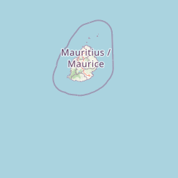
Map view of Île Plate

Use this park location map to pinpoint Île Plate in Mauritius, understand its exact geographic position, and read its mapped placement within the surrounding landscape more clearly.

Pigeon | © OpenStreetMap contributors

Location context for Île Plate

Rivière du Rempart District

Visual reference guide for coastal terrain, volcanic rock formations, and island habitats

Île Plate Landscape Photos and Protected Area Scenery Exploration

Photographic collections reveal the distinctive low-lying topography, limestone beaches, and dark basalt formations that define the natural environment of Île Plate. Visual documentation helps researchers examine protected island habitats, coastal scenery, and historical structures across the surrounding marine landscape.

A wide aerial view showing a white sandy beach curving into shallow, bright turquoise ocean water on Ile Plate, with low-lying green vegetation and a clear blue sky in the background.

Two skinks with brown and black striped patterns resting on a pebbled sandy surface.

Park atlas

Compare nearby island habitats and connected coastal reserves across the northern Mauritian lagoon.

Parks Near Île Plate and Protected Areas Across the Surrounding Regional Landscape

Browsing parks near Île Plate reveals surrounding marine reserves, islet sanctuaries, and coastal protected landscapes sharing similar Indian Ocean ecology. Comparing these neighboring protected areas expands regional geographic context and highlights connected conservation networks.
A horizontal watercolor painting showing a calm bay with green islands in the distance and a single white bird in flight against a pale sky.
Nature reserveMauritius
About 13 km away#1 closest

East

Round Island Nature Reserve: Protected Volcanic Landscape and Geography of Mauritius

Rugged volcanic terrain and endemic restoration site

Located north of the main Mauritian landmass, Round Island functions as a significant protected nature reserve. This volcanic islet is characterized by dramatic sea cliffs, steep slopes, and recovering palm forest habitats that support a high density of endemic reptiles and birds within its small geographic footprint.

Area
1.69 km²
Established
1957
Relief
Upland
Access
Highly restricted
Watercolor illustration of a forest scene with trees, ferns, and distant mountains
National parkMauritius
About 30 km away#2 closest

South

Bras d'Eau National Park: Mauritius National Park Protected Landscape Discovery

Explore coastal terrain, endemic species habitats, and wetland geography.

Bras d'Eau National Park, situated on Mauritius, offers an in-depth look at a protected coastal lowland landscape vital for conservation. This national park showcases remnant forest patches critical for endemic flora and fauna, complemented by a unique system of four mares, including the mangrove-rich Mare sarcelle. Its mapped geography provides context for island ecosystems and serves as a key location for understanding Mauritius's protected natural areas.

Area
4.97 km²
Established
2011
Relief
Lowland
Climate
Tropical
A minimalist watercolor painting showing green rolling hills and distant terrain on a white background.
Nature reserveMoka District
About 38 km away#3 closest

Southwest

Le Pouce Nature Reserve: Volcanic Geography and Protected Upland Habitat in Mauritius

A rugged basalt peak in the Moka District mountain range.

Le Pouce Nature Reserve guards a critical 0.69 square kilometer patch of upland forest on the slopes of the third highest mountain in Mauritius. This protected area is recognized for its dramatic volcanic terrain and as the rare surviving home for the critically endangered Le Pouce Mountain Screwpine, providing an essential window into the island's unique ecological and geological history within the Moka Range.

Area
0.69 km²
Established
1951
Relief
Mountain
Climate
Tropical
Nature reserveMauritius
About 53 km away#4 closest

South

Monvert Nature Park: Exploring Protected Indigenous Landscapes in Mauritius

Regenerated highland forest and endemic flora reserve

Located in the central highlands of Mauritius near Curepipe, Monvert Nature Park protects a significant portion of recovering indigenous woodland. The park functions as a major botanical conservation site, featuring an arboretum with over 150 endemic species and a network of nature trails that traverse its unique highland terrain. This reserve offers a grounded look at the island's botanical diversity and ongoing forest restoration efforts.

Relief
Upland
Climate
Subtropical
Access
Easy access
Scope
Terrestrial
Nature reserveGrand Port District
About 54 km away#5 closest

South

Vallée de Ferney Nature Reserve: Protected Mountain Landscapes in the Grand Port District

Indigenous rainforest, volcanic terrain, and conservation refuge

Located in the Bambou mountains of southeastern Mauritius, Vallée de Ferney is a 200-hectare nature reserve known for its protected indigenous rainforest and ongoing rewilding projects. As a key conservation site in the Grand Port District, the reserve offers a look at rare endemic species and the unique moisture-loving vegetation of the island's eastern volcanic series. Explore the mapped boundaries and natural terrain of this significant protected landscape.

Area
2 km²
Established
2006
Relief
Mountain
Climate
Tropical
Watercolor painting showing mountains in the distance, a body of water, and green vegetation in the foreground
National parkMauritius
About 55 km away#6 closest

Southwest

Black River Gorges National Park: Key Protected Landscape and National Park in Mauritius

Explore mapped boundaries and endemic wildlife conservation in the southwest highlands.

Black River Gorges National Park is the largest protected area on Mauritius, critically preserving native rainforest and unique endemic species. This national park encompasses approximately 67.54 square kilometers, showcasing varied ecosystems from humid upland forests to marshy heathlands within its rugged highland terrain. The park's geography, characterized by deep gorges and steep slopes, provides essential habitats and plays a crucial role in the island's conservation efforts, making it a significant site for understanding Mauritius's natural heritage.

Area
67.54 km²
Established
1994
Relief
Upland
Climate
Tropical
A horizontal watercolor painting showing green coastal vegetation, a small waterway, and distant hills under a soft sky.
National parkMauritius
About 58 km away#7 closest

South

Île aux Fouquets National Park: Coral Islet Geography and Lighthouse Heritage in Mauritius

Protected maritime landscape and offshore reef terrain

This compact coral island represents a critical piece of the national park system in Mauritius. Known for its distinct limestone geology and nineteenth-century lighthouse ruins, it provides a unique window into the maritime history and offshore reef ecosystems of the Indian Ocean, contrasting with the volcanic landforms of the mainland.

Area
0.025 km²
Established
2004
Relief
Lowland
Access
Remote access
Nature reserveMauritius
About 60 km away#8 closest

South

Ile aux Aigrettes: Exploring the Protected Coral Coastal Landscape of Mauritius

A critical nature reserve and rewilding site in the Grand Port bay

Ile aux Aigrettes represents a unique geographic outpost off the south-east coast of Mauritius, defined by its flat coral limestone terrain. As a protected nature reserve, it offers insights into the recovery of rare dry coastal forest ecosystems and the ongoing scientific efforts to maintain endemic biodiversity on a small maritime scale.

Area
0.27 km²
Established
1965
Relief
Lowland
Access
Easy access

Common questions about visiting, size, designation, and location context for Île Plate

Île Plate FAQs for park facts, access, geography, and protected area context

Find quick answers about Île Plate, including protected-area facts, park geography, trail and visitor context, and how the park fits into its surrounding country and regional landscape.
MoriAtlas Explorer

Continue Your Protected Areas Search Across the Global Atlas

Deepen your exploration by continuing the structured search for national parks and protected areas worldwide. Utilize the comprehensive filtering capabilities to compare different conservation landscapes and refine your understanding of global park geography. Discover more about the distribution and characteristics of protected natural areas.

Global natural geography