
Viewpoints
Park geography
Detailed survey of regional terrain, coastal features, and environmental classifications
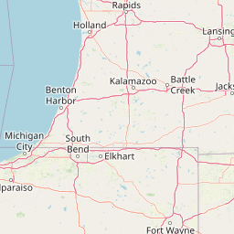
Comprehensive Geographic Profile and Mapped Boundaries of Indiana Dunes National Park
Examine the physical geography and structured boundary data of Indiana Dunes National Park in the United States. This profile outlines the park's total area of 62.12 square kilometers, its extensive coastal perimeter, and specific inland landforms ranging from dunes to wetlands and forest systems.
Related tags
National ParksLake Michigan ShorelineDune EcosystemsWetland ComplexesBirdwatching
A remarkable dune ecosystem on the southern shore of Lake Michigan
Indiana Dunes National Park
Indiana Dunes National Park protects a extraordinary stretch of Lake Michigan shoreline in northwestern Indiana, representing one of the most ecologically diverse areas in the United States National Park System. The park covers approximately 15,349 acres along 15 miles of the southern shore of Lake Michigan, spanning Porter County, Lake County, and LaPorte County. This landscape was shaped by glacial activity over thousands of years, with the Valparaiso Moraine playing a key role in creating the varied terrain of dune ridges, wetlands, prairies, and forest communities. The park is renowned for its exceptional biodiversity, supporting over 1,400 vascular plant species, which ranks it eighth among all national park units. Originally established as Indiana Dunes National Lakeshore in 1966, the designation was elevated to national park status in 2019, making it the 61st national park and the first in Indiana. The park's unique position at the southern tip of Lake Michigan creates a meeting ground for northern and southern plant and animal species, making it a critical area for ecological study and conservation.
- Location
- United States of America
- Park type
- National park
- Established
- 1966
- Area
- 62.1 km²
Location overview
Coastal park designation across three Indiana counties
National Park Geography: Indiana Dunes in the United States
Indiana Dunes National Park is located within Porter, LaPorte, and Lake counties in Indiana, United States of America. Verified administrative records outline its coastal classification and regional county boundaries.
- Countries
- United States of America
- Regions
- Indiana, Lake County, LaPorte County, Porter County
- Primary location
- United States of America
- Geographic setting
- Coastal
Boundary and coordinates
Spatial limits and geographic dimensions covering sixty-two square kilometers
Mapped Boundaries and Spatial Extent of Indiana Dunes National Park
Interactive geometry displays the spatial limits and geographic footprint of Indiana Dunes National Park. Detailed panels supply calculated land area, coordinate limits, and central points to clarify the total physical scale.
- Boundary area
- 52.7 km²
- Boundary perimeter
- 189.4 km
- Northernmost point
- 41.7169° N
- Southernmost point
- 41.5167° N
- Easternmost point
- 86.8366° W
- Westernmost point
- 87.3354° W
- Geographic centre
- 41.6395° N, 87.0896° W
- North–south span
- 22.2 km
- East–west span
- 41.6 km
Terrain and natural features
Stored upland relief classes and recorded natural features across the park
Indiana Dunes National Park Terrain and Named Natural Features
Upland terrain classifications define the regional relief across Indiana Dunes National Park. Recorded natural feature cards detail individual peaks, wetlands, and beaches located within the protected boundary.
Selected named natural features
Wetlands
North Blag Slough
Peaks
Mount Allinson
Peaks
Mount McCray
Peaks
Mount Chicago
Wetlands
Great Marsh
Environmental setting
Temperate climate zones, dominant water systems, and partial forest cover records
Indiana Dunes National Park Environmental Classifications and Physical Settings
Recorded landscape features and habitat types frame the physical setting through broad interpretive categories across the terrain. Stored classifications connect directly to relevant atlas destinations for systematic park geography analysis.
- Relief
- Upland
- Climate
- Temperate
- Water
- Water-dominated
- Forest cover
- Partial forest
- Seasonality
- Seasonal
Landscape features
Beach · Bog · Coast · Dunes · Forest · Grassland · Lakes · Marsh · Rivers · Wetland · Woodland
Habitat types
Coastal habitat · Dune habitat · Grassland · Lacustrine habitat · Peatland · Riverine habitat · Savanna · Temperate broadleaf forest · Wetland
Park atlas
Trace the geography of national parks and protected areas across the Great Lakes region and broader Midwest.
Explore Parks Near Indiana Dunes National Park and Discover Surrounding Protected Landscapes
After exploring the unique dune ecosystems and wetlands of Indiana Dunes National Park, browse other national parks and protected areas across the region. Compare the varied protected landscapes, tracing how glacial and lacustrine processes shaped diverse conservation efforts around the Great Lakes.
Protected landscapeWill County
59 km away#1 closest
West

Midewin National Tallgrass Prairie: A Protected Landscape Map in Will County Illinois
Federal tallgrass prairie restoration and ecological geography
Located in Will County, Midewin National Tallgrass Prairie is a cornerstone of American grassland conservation. This protected landscape combines diverse dolomite prairies, woodland corridors, and open grasslands, offering a deep look into the recovery of rare Midwestern ecosystems. The site functions as a living laboratory for research into native biodiversity and large-grazer ecological impact.
- Area
- 73.76 km²
- Established
- 1996
- Relief
- Lowland
- Climate
- Temperate
Marine protected areaWisconsin
About 260 km away#2 closest
North
Wisconsin Shipwreck Coast National Marine Sanctuary: Mapping Underwater Protected Cultural Landscapes
Underwater maritime archaeology and Lake Michigan basin geography.
Spanning 82 miles along the Wisconsin coastline, the Wisconsin Shipwreck Coast National Marine Sanctuary protects a unique underwater archaeological landscape. Cold, fresh water ensures the remarkable preservation of dozens of historic schooners and steamships, providing a deep look into the maritime economy of the upper Midwest. The sanctuary area offers insights into glacial lakebed terrain, bathymetric mapping, and the complex underwater geography of Lake Michigan.
- Area
- 2,490 km²
- Established
- 2021
- Relief
- Lowland
- Climate
- Temperate
Protected landscapeIndiana
277 km away#3 closest
South
Hoosier National Forest: Geographic Overview of Indiana Protected Wilderness and Woodlands
Mapping the karst terrain and forest corridors of southern Indiana.
Hoosier National Forest defines the landscape of southern Indiana with its rolling unglaciated hills and ridge systems. Discover the mapped geography of this protected area, including its rare prairie-like barrens, sandstone cliff formations, and the designated Charles C. Deam Wilderness. This overview focuses on the spatial extent and diverse topographic features that distinguish this forest from the surrounding Midwest plains.
- Area
- 826.78 km²
- Established
- 1961
- Relief
- Upland
- Climate
- Temperate

National parkMichigan
334 km away#4 closest
North
Sleeping Bear Dunes National Lakeshore: Atlas, Maps, and Protected Landscape Geography
Great Lakes freshwater coast and glacial dune systems
Sleeping Bear Dunes National Lakeshore showcases the unique intersection of glacial geology and freshwater ecology. This protected area features massive dunes resting on ancient glacial deposits, backed by beech and maple forests. The geographic scope includes the vast shoreline of Lake Michigan, inland waters such as Glen Lake, and the distinct maritime history found across the remote North and South Manitou Islands.
- Area
- 288.13 km²
- Established
- 1970
- IUCN
- III
- Visitors
- 1.5M annual
National parkOntario
346 km away#5 closest
East

Point Pelee National Park: Ontario's National Park Atlas and Protected Landscape Explorer
Mapped geography and protected area context within Ontario.
Point Pelee National Park is a designated national park in Ontario, Canada, offering a unique focus for geographic discovery. This entry details its protected landscape and mapped boundaries, essential for understanding its place within regional park atlases. Explore the core geographic identity of Point Pelee National Park and its significance as a protected natural area.
- Area
- 15 km²
- Established
- 1918
- IUCN
- II
- Visitors
- 491.1K annual
Nature reserveOhio
About 362 km away#6 closest
East
Old Woman Creek National Estuarine Research Reserve: Protected Lake Erie Estuary
Northern Ohio coastal wetland and research landscape.
Old Woman Creek National Estuarine Research Reserve represents a vital freshwater estuary on the Lake Erie shore. This reserve protects a unique combination of marsh, swamp forest, and barrier beach, providing significant insight into the natural function of Great Lakes coastal systems in northern Ohio.
- Area
- 2.32 km²
- Established
- 1980
- Relief
- Lowland
- Climate
- Temperate

Protected landscapeMichigan
About 396 km away#7 closest
Northeast
Huron, Manistee National Forests: Geography, Protected Land, and Michigan Landscape Atlas
Exploration of glacial terrain, river basins, and coastal wilderness.
The Huron, Manistee National Forests stand as a significant protected landscape in northern Michigan, featuring a vast network of inland rivers and lakes. This atlas entry provides geographic context on its glacial geology, the rare dune ecosystems along Lake Michigan, and the distribution of pine-dominated forest habitats across the two administrative units.
- Area
- 3,960 km²
- IUCN
- VI
- Relief
- Lowland
- Climate
- Temperate
National parkMissouri
404 km away#8 closest
Southwest
Gateway Arch National Park: National Park Geographic Atlas and Map Boundaries
Explore protected landscape context and regional setting.
Gateway Arch National Park represents a unique protected landscape within Missouri, contributing to the broader national park atlas. This entry focuses on its specific geographic identity and mapped boundaries, offering structured data for understanding its role. Discover the factual landscape context and regional importance of Gateway Arch National Park for informed geographic exploration.
- Area
- 0.78 km²
- Established
- 2018
- IUCN
- II
- Visitors
- 1.2M annual
MoriAtlas Explorer
Continue exploring the geography and mapped landscape of Indiana Dunes National Park
Delve deeper into the specific geographic features and protected landscape of Indiana Dunes National Park. Understanding its place within the United States of America's atlas of conservation areas offers valuable regional context and supports a comprehensive view of protected lands across North America.
Browse next
Global natural geography
Explore related park routes
Explore MoriAtlas Global ParksBrowse All MoriAtlas ParksGlobal Park Map DiscoveryMoriAtlas: Browse All CountriesBrowse All MoriAtlas ContinentsNational Park Environment AtlasGrand Canyon National Park AtlasYellowstone National Park AtlasYosemite National Park Atlas and GeographySerengeti National Park AtlasGalápagos National Park Protected LandscapeBanff National Park Geography and AtlasKruger National Park Atlas EntryUluṟu-Kata Tjuṯa National Park AtlasExplore Uluru-Kata Tjuta National Park GeographyPlitvice Lakes National Park AtlasFiordland National Park Protected LandscapeGreat Smoky Mountains National Park AtlasAfghanistan National Parks and Protected AreasAlbania National Parks and Protected AreasAlgeria National Parks and Protected AreasAmerican Samoa National Parks and Protected AreasAndorra National Parks and Protected AreasAngola National Parks and Protected AreasAntarctica National Parks and Protected AreasAntigua and Barbuda Park List