Mori Atlas logo
National parkIndre Wijdefjorden National Park

Discover the mapped protected boundaries and unique glacial fjord terrain of this vital Arctic ecosystem.

Indre Wijdefjorden National Park: Europe's High Arctic Steppe Protected Landscape in Svalbard

(Indre Wijdefjorden nasjonalpark)

Indre Wijdefjorden National Park safeguards a rare High Arctic steppe ecosystem, the only one of its kind in Europe, located within the dramatic fjord landscape of northern Spitsbergen, Norway. This protected area, spanning land and marine zones, offers a unique opportunity to explore a geography defined by extremely low precipitation and mineral-rich earth, fostering endemic plant species found nowhere else. The park's distinct terrain, from its narrow fjord mouth to its deep interior basin, presents a compelling case for Arctic conservation and landscape atlas discovery.

Arctic wildernessHigh Arctic steppeFjord landscapeEndemic speciesGlacial environmentProtected area

Indre Wijdefjorden National Park

National park

Park overview

Structured park overview, official facts, and landscape profile for Indre Wijdefjorden National Park

Indre Wijdefjorden National Park park facts, protected area profile, and essential visitor context
Review the core facts for Indre Wijdefjorden National Park, including designation, size, terrain, visitor scale, habitats, and operating context in one park-focused overview.

About Indre Wijdefjorden National Park

Indre Wijdefjorden National Park protects a remote and ecologically significant corner of the Svalbard archipelago. The park encompasses the inner sections of Wijdefjorden, a fjord so named for its wide mouth that narrows dramatically as it extends inland. This 108-kilometre fjord is the longest in Svalbard, and the protected area within it represents the archipelago's smallest national park despite its substantial area of over 1,100 square kilometres. The park's significance stems primarily from its unique vegetation, which has evolved in response to extraordinarily low precipitation and mineral-rich soils. Unlike the glacial and tundra landscapes that dominate most of Svalbard, the slopes flanking Wijdefjorden support a grassland steppe more typical of continental Arctic regions. This ecological distinction has drawn scientific attention, as the area represents an ecological refugium that has retained plant communities absent from the rest of the archipelago. The park also includes significant cultural heritage from the trapping era, with historical cabins at Krosspynten, Purpurdalen, and Austfjordnes representing early 20th-century human presence in this otherwise sparsely visited wilderness.

Quick facts and research context for Indre Wijdefjorden National Park

Indre Wijdefjorden National Park lies on the northern coast of Spitsbergen between Andrée Land to the west, Dickson Land to the south, and Ny-Friesland to the east. The fjord splits internally into Austfjorden (32 kilometres long) to the east and the shorter Vestfjorden to the west, with the glacier Mittag-Lefflerbreen at the innermost section. The park experiences an Arctic climate with July averages of 4 to 6°C and January temperatures between -12 and -16°C, though the North Atlantic Current moderates conditions compared to similar latitudes on continental landmasses. Permafrost extends up to 100 metres deep. The marine environment features a shallow 50-metre section at Elvetangen that restricts water circulation, creating a cold basin reaching 250 metres depth in the inner fjord. Of all the larger fjords on Svalbard, Wijdefjorden remains the least affected by human activity.

Park context

Deeper park guide and search-rich context for Indre Wijdefjorden National Park

Indre Wijdefjorden National Park history, landscape, wildlife, and travel context
Explore Indre Wijdefjorden National Park through its history, landscape character, ecosystems, wildlife, conservation priorities, cultural context, and seasonal travel timing in a structured park guide built for atlas discovery and search intent.

Why Indre Wijdefjorden National Park stands out

Indre Wijdefjorden is renowned for harboring Europe's only High Arctic steppe ecosystem, a rare landscape characterized by grasses growing on extremely dry, basic earth with salt deposits. This unique vegetation is not preserved anywhere else in Svalbard and represents one of only two such areas in the Northern Hemisphere, with the other located in the Canadian Arctic Archipelago. The park contains several endemic plant species found nowhere else in Europe, including Stepperøykvein (featured in the park's logo), Puccinellia svalbardensis, Gentianella tenella, and Kobresia simpliciuscula. The fjord's exceptional ecological significance, combined with its status as Svalbard's least human-impacted large fjord, makes it a flagship for Arctic conservation.

Indre Wijdefjorden National Park history and protected-area timeline

Human activity in the Wijdefjorden area began with Russian trappers followed by Norwegian hunters in the early 1900s. A trapping cabin was erected at Krosspynten in 1910, with another constructed at Purpurdalen two years later. Trappers found the area offered few polar bears but abundant Arctic foxes, with the ability to supplement their catch with common eider. Records from 1928 indicate a single season yielded approximately 50 Arctic foxes. In 1932, the area's distinctive vegetation received formal protection, a designation that was later incorporated into the national park framework upon its establishment. Trapping activity declined but resumed in the 1980s, with the Governor of Svalbard maintaining a cabin at Austfjordnes available for seasonal rental. Prior to the national park's establishment, a conflict emerged with the mining industry when Svalbard Minerals discovered baryte deposits within the proposed park boundaries. Despite this, the national park was established on 9 September 2005 as part of a multi-year initiative to increase Svalbard's protected area coverage from 55% to 65%, joining Nordenskiöld Land, Sassen-Bünsow Land, and Nordre Isfjorden national parks created in the preceding years.

Indre Wijdefjorden National Park landscape and geographic character

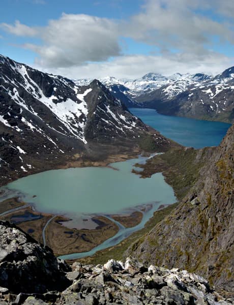
The landscape of Indre Wijdefjorden National Park is defined by steep mountainous terrain flanking a long, narrow fjord that penetrates deep into northern Spitsbergen. The fjord's distinctive shape—wide at its mouth but constricted at Elvetangen where depths drop to just 50 metres—creates unique hydrological conditions in the inner sections. Beyond this shallow threshold, the fjord deepens into a cold-water basin reaching 250 metres before terminating at the glacier Mittag-Lefflerbreen. The western and eastern sides of the fjord present different geological characters: the west features Devonian period deposits while the east is characterized by older bedrock, resulting in distinct vegetation patterns on each side. Mountain ridges rise sharply from the water's edge, creating a dramatic backdrop of rock and ice. The inner fjord receives among the lowest precipitation recorded anywhere in the Svalbard archipelago, a climatic condition essential to maintaining the High Arctic steppe ecosystem that defines the park's ecological character.

Indre Wijdefjorden National Park ecosystems, habitats, and plant life

The nature of Indre Wijdefjorden is distinguished by its High Arctic steppe vegetation, a unique ecosystem within the European Arctic that exists in only one other location in the Northern Hemisphere. This grassland community thrives on extremely dry conditions, basic soils containing salt deposits, and extensive areas of exposed mineral earth. The vegetation is dominated by grasses that have adapted to the harsh conditions, creating a landscape that contrasts sharply with the moss-dominated tundra found throughout most of Svalbard. The park contains plant species of exceptional conservation significance, including Stepperøykvein, for which Svalbard represents the only known European location, along with Puccinellia svalbardensis, Gentianella tenella, and Kobresia simpliciuscula. This flora, combined with the vegetation found on Svalbard's nesting cliffs, represents the most exclusive plant communities in the entire archipelago. The extreme light conditions shape all biological activity: the polar night brings months of dormancy while the midnight sun of summer accelerates natural processes. Climate models indicate the area's unique ecosystem may be particularly vulnerable to warming, as increased precipitation could fundamentally alter the dry conditions upon which the steppe depends.

Indre Wijdefjorden National Park wildlife and species highlights

Wildlife in Indre Wijdefjorden National Park includes several Arctic species characteristic of Svalbard's ecosystems. Polar bears occasionally traverse the area, though they are more commonly associated with the sea ice. The park supports populations of Svalbard reindeer, a distinct subspecies adapted to the Arctic environment, as well as Arctic foxes that historically were the target of trapping activities. Bird life includes pink-footed goose, which uses the area as breeding grounds, and Svalbard ptarmigan, the archipelago's only resident bird species. The marine environment, transitioning from the fjord mouth through the cold basin to the glacial front at Mittag-Lefflerbreen, supports its own ecological communities. The extreme seasonality shapes wildlife behavior, with activity ceasing during the polar night and accelerating dramatically during the summer months of continuous daylight.

Indre Wijdefjorden National Park conservation status and protection priorities

Indre Wijdefjorden holds exceptional conservation significance as Europe's only High Arctic steppe and one of two such ecosystems in the Northern Hemisphere. The park's vegetation represents a conservation priority of international importance, hosting species found nowhere else in Europe. The area's designation in 2005 as a national park was part of Norway's systematic expansion of protected areas across Svalbard. The park operates under the strictest regulations in the archipelago, with a complete prohibition on building construction, road laying, earthwork, drilling, blasting, and extraction of petroleum, gas, and minerals. Management follows the Svalbard Environmental Protection Act, with day-to-day operations delegated to the Governor of Svalbard and the Norwegian Directorate for Nature Management. The entire Svalbard archipelago, including this national park, appears on Norway's tentative list for UNESCO World Heritage recognition, reflecting its outstanding universal value as a managed wilderness area.

Indre Wijdefjorden National Park cultural meaning and human context

The cultural context of Indre Wijdefjorden centers on the trapping heritage that shaped human presence in this remote Arctic landscape. Russian trappers were the first to use the area, followed by Norwegian hunters who established cabins at Krosspynten in 1910 and Purpurdalen in 1912. These structures remain visible reminders of the seasonal hunting activities that characterized human interaction with this harsh environment. The area's long history of trapping, while minimal compared to other Svalbard fjords, nonetheless left a cultural imprint reflected in the continued presence of historic cabins. The Governor of Svalbard maintains a cabin at Austfjordnes that remains available for seasonal rental, connecting contemporary visitors to this historical use pattern. The broader Svalbard context includes the archipelago's unique political status under the Svalbard Treaty, which grants certain rights to signatory nations while requiring Norway to maintain environmental protection—a framework that shapes all conservation and management decisions within the national park.

Top sights and standout views in Indre Wijdefjorden National Park

Indre Wijdefjorden National Park protects one of the Arctic's most ecologically significant landscapes, representing Europe's sole High Arctic steppe ecosystem. The park's endemic plant species, including Stepperøykvein found nowhere else in Europe, underscore its global conservation importance. As Svalbard's longest fjord and the least human-impacted of the archipelago's major fjords, it embodies wilderness values that have earned consideration for UNESCO World Heritage status. The dramatic transition from the wide fjord mouth through a shallow constriction to the deep cold basin at the glacier terminus creates a unique marine environment. The strict protection regime, which prohibits all construction and resource extraction, positions this as a model for Arctic wilderness conservation.

Best time to visit Indre Wijdefjorden National Park

Access to Indre Wijdefjorden is possible primarily during the summer months when the fjord is ice-free and can be reached by boat from the north. The period of midnight sun from late May to late July offers continuous daylight for exploration, though the short summer season limits visitation windows. Winter access from Longyearbyen by snowmobile or ski is possible but requires significant preparation and carries inherent Arctic wilderness risks. The extreme light conditions fundamentally shape the visiting experience: summer brings the opportunity for around-the-clock activity under the midnight sun, while the polar night renders the interior essentially inaccessible for much of the year. The brief summer season, while offering the most practical access, coincides with the peak of biological activity when the unique vegetation is most visible.

Park location guide

Geography guide, regional context, and park location map for Indre Wijdefjorden National Park

Indre Wijdefjorden National Park park geography, regions, and map view in Norway
Understand where Indre Wijdefjorden National Park sits in Norway through a broader geographic reading of the surrounding landscape, nearby location context, and its mapped position within the national park landscape.

How Indre Wijdefjorden National Park fits into Norway

Norway, officially the Kingdom of Norway, is a Nordic country in Northern Europe located on the Scandinavian Peninsula. It encompasses mainland Norway, the Arctic islands of Svalbard and Jan Mayen, and maintains dependencies including Bouvet Island and Antarctic claims. The country has a population of about 5.6 million and is bordered by Sweden, Finland, and Russia. Norway is a unitary parliamentary constitutional monarchy with Oslo as its capital and largest city.

Wider geography shaping Indre Wijdefjorden National Park in Norway

Norway occupies the western and northern portions of the Scandinavian Peninsula in Northern Europe. The country shares a long eastern border with Sweden, and borders Finland and Russia to the northeast. Norway has an extensive coastline facing the Skagerrak, North Sea, Norwegian Sea, and Barents Sea. The terrain is predominantly mountainous with numerous fjords along the coastline.

Map view of Indre Wijdefjorden National Park

Use this park location map to pinpoint Indre Wijdefjorden National Park in Norway, understand its exact geographic position, and read its mapped placement within the surrounding landscape more clearly.

Pigeon | © OpenStreetMap contributors

Location context for Indre Wijdefjorden National Park

Svalbard
Park atlas

Compare Adjacent Protected Landscapes and Trace the Regional Spread of Svalbard's Unique Arctic Wilderness.

Explore More Arctic National Parks and Protected Areas Near Indre Wijdefjorden National Park
Browse other national parks and protected areas across northern Spitsbergen and the Svalbard archipelago, tracing the unique High Arctic steppe, fjord landscapes, and glacial environments that define this polar region. Discover how these neighboring conservation areas connect to Indre Wijdefjorden National Park, providing a comprehensive atlas view of regional protected geography for in-depth comparison.
National parkSvalbard

Sassen, Bünsow Land National Park: A Mapped Arctic Glacial Landscape in Svalbard

Explore protected boundaries and polar terrain.

Sassen, Bünsow Land National Park, located in the heart of Spitsbergen, Norway, showcases a quintessential Arctic wilderness defined by its expansive glacial features and deeply incised valleys. This protected area, part of the Svalbard archipelago, offers rich geographic context through its mapped terrain, highlighting glacial processes that have shaped the landscape. Discover the unique polar environment and the significance of this national park within the broader Norwegian Arctic atlas.

Area
1,230 km²
Established
2003
IUCN
II
Relief
Mountain
Watercolor illustration of a fjord with mountains, trees, and water bodies
National parkSpitsbergen

Nordre Isfjorden National Park: Arctic Coastal Protected Landscape

Discover Spitsbergen's mapped fjord geography and wildlife.

Nordre Isfjorden National Park on Spitsbergen offers a compelling view into a pristine Arctic environment. This protected national park encompasses dramatic coastal cliffs, tundra terrain, and the biologically rich waters of Isfjorden. It is renowned for supporting immense seabird colonies that rely on the nutrient-dense fjord, making it a significant site for understanding high Arctic ecosystems and marine protected areas.

Area
2,954 km²
Established
2003
IUCN
II
Relief
Lowland
National parkSvalbard

Nordvest-Spitsbergen National Park: Protected Arctic Landscape and Geographic Atlas

Explore unique hot springs, glacial terrain, and polar expedition history.

Nordvest-Spitsbergen National Park, a protected national park in Norway's Svalbard archipelago, showcases dramatic Arctic geography. This page details its mapped landscapes, from volcanic terrains and glacial valleys to its famed northernmost hot springs. Discover the park's protected area status, its role in regional geography, and its historical significance for polar exploration, providing a rich context for atlas-based exploration.

Area
9,914 km²
Established
1973
IUCN
II
Relief
Mixed relief
National parkSvalbard

Forlandet National Park: High Arctic Protected Landscape and Global Wildlife Limits

Explore mapped geography and protected ecosystem boundaries in Svalbard.

Forlandet National Park stands as a crucial element in the Arctic atlas, safeguarding the island of Prins Karls Forland and its surrounding marine territories. As the world's most northerly national park, it showcases a unique High Arctic landscape defined by stark coastal cliffs and vital waters supporting specialized wildlife. This protected area is recognized for harboring the most extreme northern populations of seals and common guillemots, making it a significant site for understanding polar ecosystems and conservation efforts within the Svalbard region.

Area
4,647 km²
Established
1973
IUCN
II
Relief
Lowland
National park

Sør-Spitsbergen National Park: Mapping Norway's Pristine Arctic Protected Landscape

Explore glacial terrain, tundra ecosystems, and significant seabird colonies.

Delve into Sør-Spitsbergen National Park, a cornerstone of Arctic protected areas within Norway's Svalbard archipelago. This extensive national park showcases raw glacial terrain, expansive ice caps, and sparse tundra valleys, offering a unique geographic context. It is globally recognized for its vast seabird colonies, particularly the dense nesting sites of thick-billed guillemots, and Ramsar-protected wetlands. Understanding Sør-Spitsbergen National Park through its mapped boundaries and landscape features provides critical insight into Arctic conservation and natural processes.

Area
8,504 km²
Established
1973
IUCN
II
Relief
Mixed relief
National parkFinnmark

Seiland National Park: Arctic Island Landscape and Northernmost Scandinavian Glaciers

Mapped boundaries of protected terrain in Finnmark

Seiland National Park offers a distinct glimpse into Arctic island geography, renowned for protecting Scandinavia's northernmost glaciers. This protected area in Finnmark features a dramatic landscape shaped by glaciated mountains, deep coastal fjords, and alpine terrain, making it a key destination for understanding Nordic natural environments. MoriAtlas facilitates exploration of its mapped boundaries and the unique combination of glacial and marine ecosystems present.

Area
316 km²
Established
2006
IUCN
II
Relief
Mountain
National park

Stabbursdalen National Park: Protected Arctic Landscape and Northernmost Pine Forest Atlas

Explore Finnmark's unique geography and protected terrain.

Stabbursdalen National Park preserves a remarkable ecological boundary, featuring the planet's northernmost Scots pine woodland within a dramatic Arctic landscape. This protected area offers a deep dive into rugged mountain terrain, river valley formations, and vital wetland habitats. As a key component of Norway's protected lands, it provides essential context for understanding regional geography and the limits of forest ecosystems on the mapped landscape.

Area
747 km²
Established
1970
IUCN
II
Relief
Mixed relief
National parkFinnmark

Varangerhalvøya National Park: Explore Finnmark's Unique Subarctic Protected Landscape

Mapped tundra, wetlands, and Arctic fox conservation.

Varangerhalvøya National Park offers a compelling atlas exploration of Norway's northeasternmost protected landscapes. This national park in Finnmark is distinguished by its subarctic terrain, featuring expansive tundra, diverse wetlands, and a unique ecological position where multiple biomes converge. It is a critical habitat for the Arctic fox and a vital Important Bird Area, providing deep insights into protected area geography and landscape context for those studying regional conservation and natural formations.

Area
1,804.1 km²
Established
2006
IUCN
II
Relief
Lowland

Common questions about visiting, size, designation, and location context for Indre Wijdefjorden National Park

Indre Wijdefjorden National Park FAQs for park facts, access, geography, and protected area context
Find quick answers about Indre Wijdefjorden National Park, including protected-area facts, park geography, trail and visitor context, and how the park fits into its surrounding country and regional landscape.
MoriAtlas Explorer

Continue Your Protected Areas Search Across the Global Atlas

Deepen your exploration by continuing the structured search for national parks and protected areas worldwide. Utilize the comprehensive filtering capabilities to compare different conservation landscapes and refine your understanding of global park geography. Discover more about the distribution and characteristics of protected natural areas.

Global natural geography