
Lakes
Park geography
Technical analysis of territorial extent, mountain terrain, and coastal landscapes
Geographic Profile and Mapped Boundaries of Isla Magdalena National Park in the Aysén Region
Isla Magdalena National Park spans 1576 square kilometers within the Aysén del General Carlos Ibáñez del Campo Region. This geography profile details the physical distribution of the protected area, covering mountain terrain, volcanic features like Volcán Mentolat, coastal islands, and surrounding strait systems.
Related tags
PatagoniaMagellanic ForestVolcanic LandscapeIsland WildernessRemote Protected Area
Remote Patagonian island park protecting vast Magellanic forest wilderness and volcanic peaks
Isla Magdalena National Park
Isla Magdalena National Park is a sprawling protected wilderness area encompassing the entirety of Magdalena Island in the remote Aysén Region of Chilean Patagonia. Established originally as a forest reserve in 1967 and redesignated as a national park in 1983, the park covers approximately 1,576 square kilometers of rugged Patagonian terrain. The island lies within the temperate rainforests of southern Chile, characterized by dense Magellanic forests, dramatic mountain peaks including Mentolat Volcano, and a network of smaller islands scattered across its coastal waters. Puerto Gaviota in the southern portion of the park is noted as a particularly noteworthy location within this remote protected area. The park remains largely undeveloped, with no road infrastructure on the island itself, requiring visitors to arrive by sea from the nearest port communities of Puerto Cisnes or Puerto Puyuhuapi.
- Location
- Chile
- Park type
- National park
- Established
- 1983
- Area
- 1,576 km²
- Highest point
- 1,660 m
Location overview
Coastal and marine protected territory in the Aysén Region
Geographic Setting of Isla Magdalena National Park in Chile
Isla Magdalena National Park lies within the Aysén del General Carlos Ibáñez del Campo Region of Chile. The protected zone encompasses coastal, island, and marine territory without crossing international borders.
- Countries
- Chile
- Regions
- Aysén del General Carlos Ibáñez del Campo Region
- Primary location
- Aysén del General Carlos Ibáñez del Campo Region
- Geographic setting
- Coastal · Island · Marine
Boundary and coordinates
Mapping the spatial footprint and total area across 1576 square kilometres
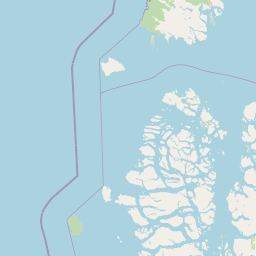
Isla Magdalena National Park Boundary Map and Spatial Extent
The interactive geographic boundary outline provides crucial spatial context for Isla Magdalena National Park. Accompanying datasets detail the 1576 square kilometre area alongside derived center coordinates, spans, and regional limits.
- Boundary area
- 2,555.7 km²
- Boundary perimeter
- 683.5 km
- Northernmost point
- 44.2907° S
- Southernmost point
- 44.9477° S
- Easternmost point
- 72.6887° W
- Westernmost point
- 73.4731° W
- Geographic centre
- 44.6059° S, 73.1226° W
- North–south span
- 73 km
- East–west span
- 62.3 km
Elevation and terrain
Mountain relief range and recorded natural features
Isla Magdalena National Park Terrain and Elevation Summary
Recorded elevation records place the highest point at 1660 meters within the mountain terrain classification. Linked natural feature cards detail names, types, and spatial relationships across the protected area.
- Highest point
- 1,660 m
Selected named natural features
Straits
Canal Puyuhuapi
Straits
Canal Frodden
Islands
Isla Enrique
Islands
Isla Larga
Islands
Islote Inés
Environmental setting
Temperate climate zones, mountain relief, and major water features across coastal islands
Isla Magdalena National Park Environmental and Landscape Classifications
Recorded landscape features and forest cover provide complementary ways to read the physical setting of Isla Magdalena National Park. Mapped classifications connect stored categories to relevant protected area destinations within the regional atlas.
- Relief
- Mountain
- Climate
- Temperate
- Water
- Major water bodies
- Forest cover
- Mostly forested
Landscape features
Islands · Volcano · Mountains · Coast
Park atlas
Trace the wider protected landscapes of Chilean Patagonia, comparing national parks and regional protected areas surrounding Isla Magdalena National Park.
Discover Other Patagonian National Parks and Protected Areas Near Isla Magdalena National Park
After exploring Isla Magdalena National Park, browse other national parks and protected areas across Chilean Patagonia's vast and diverse landscapes, including coastal islands, volcanic terrain, and extensive Magellanic forests. Comparing these protected areas offers invaluable geographic context, revealing how varied conservation efforts map across the remote Aysén Region and its unique wilderness character.
National parkAysén Region
1.8 km away#1 closest
North

Melimoyu National Park: A Key Protected National Park within Chile's Aysén Region
Explore Melimoyu National Park's mapped boundaries and regional geography.
Melimoyu National Park stands as a distinct protected natural area, offering a focused lens for geographic discovery. As a national park situated in the Aysén Region, its mapped boundaries and regional landscape context are crucial for understanding its atlas significance. This entry provides specific details about the park's protected status and its contribution to the mapped terrain of southern Chile, enabling detailed exploration for atlas enthusiasts.
- Area
- 1,055 km²
- Established
- 2018
- IUCN
- II
- Relief
- Mixed relief
National parkAysén del General Carlos Ibáñez del Campo Region
6.3 km away#2 closest
Northeast
Queulat National Park: Patagonian Andes Glacier and Rainforest Discovery
Mapped protected area in Aysén del General Carlos Ibáñez del Campo Region.
Queulat National Park is a vast protected wilderness in southern Chile, renowned for its dramatic glacial alpine terrain and lush temperate rainforests. The park's geography is defined by steep glacial valleys, ice fields, and the iconic Queulat Hanging Glacier cascading from sheer cliffs. Discover the mapped boundaries of this significant Patagonian national park, offering unparalleled insight into its unique ecosystems and dramatic landscapes shaped by ice and forest.
- Area
- 1,541 km²
- Established
- 1983
- IUCN
- II
- Relief
- Mountain
National parkChile
42 km away#3 closest
North
Corcovado National Park, Chile: Protected Volcanic Landscapes and Glacial Wilderness Atlas
Detailed geography of Chile's remote coastal wilderness and marine estuaries
Corcovado National Park stands as a significant protected area in southern Chile, encompassing dramatic volcanic peaks and an extensive collection of glacial lakes. Its mapped boundaries reveal a remote wilderness where pristine temperate rainforests transition into the brackish estuaries of the Gulf of Corcovado, supporting vital marine ecosystems and critical blue whale populations.
- Area
- 2,096 km²
- Established
- 2005
- IUCN
- II
- Relief
- Mixed relief
National parkAysén del General Carlos Ibáñez del Campo Region
111 km away#4 closest
Southeast
Cerro Castillo National Park: Dramatic Granite Peaks and Patagonian Protected Landscape
Mapped geography and huemul conservation in Chile's Aysén Region.
Cerro Castillo National Park is a premier protected area in southern Chile, celebrated for its iconic Cerro Castillo granite mountain that dominates the landscape. This national park, spanning over 1,700 square kilometers in the Aysén del General Carlos Ibáñez del Campo Region, showcases a dynamic Patagonian terrain shaped by glaciers and rivers. Its significance extends to being a vital corridor for endangered huemul, offering critical habitat within a broader regional conservation strategy and the famous Route of Parks.
- Area
- 1,795.5 km²
- Established
- 1970
- IUCN
- II
- Relief
- Mountain
National parkChile
About 129 km away#5 closest
West
Isla Guamblin National Park: A Protected Landscape Within Chile's Geography
Explore the mapped terrain and boundaries of this national park.
Isla Guamblin National Park provides essential context for understanding protected lands in Chile. This detail page offers a focused view on its geographic features and mapped natural landscape, crucial for atlas-based exploration and regional conservation studies. Discover the specific identity of this national park and its contribution to the mapped protected areas of South America.
- Area
- 106.25 km²
- Established
- 1967
- Relief
- Lowland
- Climate
- Temperate
National parkAysén del General Carlos Ibáñez del Campo Region
152 km away#6 closest
South
Laguna San Rafael National Park: Explore its Mapped Boundaries and Patagonian Landscape
A National Park within Aysén del General Carlos Ibáñez del Campo Region.
Laguna San Rafael National Park stands as a key protected area within the vast geography of the Aysén del General Carlos Ibáñez del Campo Region. This entry provides an atlas-focused perspective, detailing the park's geographic significance, mapped natural landscapes, and its role as a vital conservation territory. Understand how this national park fits into the broader context of Patagonia's unique terrain and protected areas.
- Area
- 17,420 km²
- Established
- 1959
- IUCN
- II
- Relief
- Mountain
National parkArgentina
158 km away#7 closest
Northeast

Los Alerces National Park: Ancient Alerce Forests and Glacial Terrain in Argentina
Discover the park's protected landscape and regional geography.
Los Alerces National Park in Argentina is a globally significant protected area, celebrated for its ancient alerce forests, some of the longest-living trees on Earth. This national park showcases a dramatic landscape shaped by glaciers, featuring a series of interconnected lakes and rugged Andean terrain. Explore the unique ecosystem and mapped geography of this UNESCO World Heritage site to understand its profound natural and conservation value.
- Area
- 2,599 km²
- Established
- 1937
- IUCN
- II
- Relief
- Mountain
National parkAysén Region
194 km away#8 closest
South
Patagonia National Park, Chile: Exploring Protected Landscape and Regional Geography
Mapped boundaries and natural terrain in Aysén Region.
Patagonia National Park, situated within the Aysén Region of Chile, serves as a significant protected area offering rich opportunities for atlas-based geographic exploration. This national park's specific landscape identity and mapped boundaries provide a clear focal point for understanding regional conservation and natural terrain. Discover the geographic context of this protected land and its place within the broader landscape of southern Chile through structured data and map exploration.
- Area
- 3,045.28 km²
- Established
- 2018
- IUCN
- II
- Relief
- Mountain
MoriAtlas Explorer
Continue exploring Isla Magdalena National Park's geographic and protected landscape identity
To deepen your understanding of Isla Magdalena National Park, focus on its precise geographic location and protected landscape features. Examining the park's mapped boundaries within the Aysén region offers critical context for atlas-based discovery and appreciating its role as a national park entity.
Browse next
Global natural geography
Explore related park routes
Explore MoriAtlas Global ParksBrowse All MoriAtlas ParksGlobal Park Map DiscoveryMoriAtlas: Browse All CountriesBrowse All MoriAtlas ContinentsNational Park Environment AtlasGrand Canyon National Park AtlasYellowstone National Park AtlasYosemite National Park Atlas and GeographySerengeti National Park AtlasGalápagos National Park Protected LandscapeBanff National Park Geography and AtlasKruger National Park Atlas EntryUluṟu-Kata Tjuṯa National Park AtlasExplore Uluru-Kata Tjuta National Park GeographyPlitvice Lakes National Park AtlasFiordland National Park Protected LandscapeGreat Smoky Mountains National Park AtlasAfghanistan National Parks and Protected AreasAlbania National Parks and Protected AreasAlgeria National Parks and Protected AreasAmerican Samoa National Parks and Protected AreasAndorra National Parks and Protected AreasAngola National Parks and Protected AreasAntarctica National Parks and Protected AreasAntigua and Barbuda Park List