
Rivers
Park geography
Structured data on mapped boundaries, mountain terrain, and regional natural features
Geographic Profile of José Armando Bermúdez National Park in the Dominican Republic
Examine the detailed geographic characteristics of José Armando Bermúdez National Park, covering a total recorded area of 766 square kilometers. This profile details the mountain-dominated terrain, including named peaks such as Loma La Rucilla, and the extensive network of river systems within the park boundaries, set against a subtropical climate and temperate forest habitat.
Related tags
national parkmountain forestpine ecosystemendemic speciestropical highlands
High-altitude pine forests in tropical Hispaniola
José Armando Bermúdez National Park
José Armando Bermúdez National Park is a protected mountain area in the Dominican Republic covering approximately 766 square kilometers across the provinces of San Juan, Santiago, and La Vega. The park occupies the northern slopes and central portions of the Cordillera Central, the highest mountain range in the Caribbean. Established in February 1956 alongside José del Carmen Ramírez National Park, it represents one of the oldest protected areas in the country. What makes this park particularly distinctive is its cool, sometimes cold climate despite the Dominican Republic's tropical setting. Temperatures can drop to -9°C in higher elevations and typically range between freezing and 15°C throughout much of the year, creating an unusual alpine environment within the tropics.
- Location
- Dominican Republic
- Park type
- National park
- Established
- 1956
- Area
- 766 km²
Location overview
National territory status and placement in the Dominican Republic
Geographic Setting of José Armando Bermúdez National Park in the Dominican Republic
José Armando Bermúdez National Park is located entirely within the sovereign territory of the Dominican Republic. As a solely terrestrial protected area, the reserve features no marine, coastal, or transboundary zones.
- Countries
- Dominican Republic
- Primary location
- Dominican Republic
- Geographic setting
- Inland
Boundary and coordinates
Mapping the 766 square kilometer protected area and coordinate limits
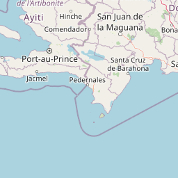
José Armando Bermúdez National Park Boundary Map and Spatial Limits
Visualizing the mapped outline reveals how the protected terrain is positioned geographically. Related geographic data provides key figures for the total 766 square kilometer area, perimeter, and center coordinates.
- Boundary area
- 802.2 km²
- Boundary perimeter
- 230 km
- Northernmost point
- 19.302° N
- Southernmost point
- 19.0059° N
- Easternmost point
- 70.8001° W
- Westernmost point
- 71.4408° W
- Geographic centre
- 19.163° N, 71.0966° W
- North–south span
- 32.8 km
- East–west span
- 67.4 km
Terrain and natural features
Explore recorded mountain terrain classifications and internal natural features
José Armando Bermúdez National Park Terrain and Named Natural Features
Mountain park terrain classifications define the regional landscape of José Armando Bermúdez National Park. Linked feature cards supply names, types, and spatial relationships for recorded natural features within the protected boundary.
Selected named natural features
Rivers
Río Maguá
Peaks
Pico Yaque
2,770 m
Rivers
Arroyo Guácara
Rivers
Río Yaque del Norte
Rivers
Arroyo Guacarita
Environmental setting
Temperate Coniferous Forest Cover, Subtropical Climate Zones, and Mountain Relief
José Armando Bermúdez National Park Environmental Settings and Mapped Terrain Classifications
Recorded mountain relief, temperate coniferous forest cover, and subtropical climate zones provide complementary ways to read the physical setting of José Armando Bermúdez National Park. Stored classifications connect recorded categories to relevant atlas destinations across the protected landscape.
- Relief
- Mountain
- Climate
- Subtropical
- Water
- Minor water
- Forest cover
- Mostly forested
- Seasonality
- Year-round
Landscape features
Mountains
Habitat types
Temperate coniferous forest
Park atlas
Compare diverse protected landscapes and mountain ecosystems across the Dominican Republic's Cordillera Central.
Explore Nearby National Parks and Protected Areas Surrounding José Armando Bermúdez
Explore additional national parks and protected areas within the Cordillera Central, tracing mountain forests and cool-climate ecosystems adjacent to José Armando Bermúdez National Park. Compare these protected landscapes to understand the regional spread of conservation efforts and the varied terrain of the Dominican Republic.
National parkDominican Republic
13 km away#1 closest
Southeast

Valle Nuevo National Park: Nearctic Highland Ecosystem and Glacial Landscapes
Mapped protected area in the Dominican Republic's Cordillera Central.
Valle Nuevo National Park in the Dominican Republic offers a rare glimpse into a Nearctic ecosystem within the Caribbean. Spanning 910 square kilometers in the Cordillera Central, it features dramatic mountain peaks like Loma Alto de la Bandera and distinctive glacial landforms. The park protects extensive Hispaniolan pine forests and cloud forest habitats, supporting remarkable endemic biodiversity and serving as a critical watershed for the region.
- Area
- 910 km²
- Established
- 1996
- IUCN
- II
- Relief
- Mountain
National parkDominican Republic
About 33 km away#2 closest
East
Pueblo Viejo National Park: Dominican Republic Colonial Ruins and Gold Mining Heritage
Explore early Caribbean colonization and its archaeological landscape.
Pueblo Viejo National Park stands as a crucial archaeological site in the Dominican Republic, preserving the remnants of Concepción de la Vega, a significant colonial settlement established during the era of Christopher Columbus. This national park offers a unique window into the beginnings of European presence and the first major gold extraction operations in the Americas. Examine the mapped foundations of its fortress and town structures, understanding the colonial urban planning and the historical geography of early Caribbean heritage.
- IUCN
- II
- Access
- Easy access
- Scope
- Terrestrial
- Water
- No major water
National parkMonte Cristi Province
60 km away#3 closest
Northwest
Monte Cristi National Park: Dominican Republic National Park Geography and Atlas
Explore mapped boundaries and regional landscape context.
Monte Cristi National Park serves as a vital component of the Dominican Republic's protected lands, located within the Monte Cristi Province. This entry provides essential geographic context and visualizes the park's mapped boundaries, contributing to a comprehensive understanding of its landscape. Delve into the atlas perspective of this national park, examining its terrain and regional significance for structured geographic exploration.
- Area
- 550 km²
- Established
- 1983
- IUCN
- II
- Relief
- Upland
National parkIndependencia Province
About 78 km away#4 closest
South
La Gran Sabana National Park: National Park Identity and Geographic Mapping
Exploring protected landscapes and regional context.
This detail entry focuses on La Gran Sabana National Park, delineating its identity as a protected national park within Independencia Province. It provides essential context for understanding the park's mapped boundaries, its specific geographic setting, and its role within the natural landscape. Users can explore its atlas-relevant features and understand its place in the broader geography of the Dominican Republic.
- Area
- 219.58 km²
- Established
- 2009
- IUCN
- II
- Relief
- Lowland
National parkHaiti
About 83 km away#5 closest
Northwest

Three Bays Protected Area National Park: Haiti's Extensive Marine and Coastal Protected Landscape
Mapped coral reefs, mangrove forests, and unique regional geography.
The Three Bays Protected Area in Haiti is a key national park established to conserve its vital marine and coastal environments. Covering over 75,000 hectares, it is the country's largest protected marine complex, encompassing extensive and healthy coral reefs, critical seagrass beds, and sprawling mangrove forests. This protected landscape provides essential ecosystem services and coastal protection, showcasing a significant portion of Haiti's natural heritage and regional geographic context along its northeastern shoreline.
- Area
- 754.06 km²
- Established
- 2014
- IUCN
- IV
- Relief
- Lowland
National parkDominican Republic
86 km away#6 closest
East
Los Haitises National Park: Dominican Republic Protected Landscape & Park Geography
Mapped terrain and protected area boundaries in the Dominican Republic.
Los Haitises National Park is a vital protected national park in the Dominican Republic, offering unique insights into the region's geography and natural landscapes. This page delves into its mapped boundaries, regional context, and the importance of its protected status for understanding Dominican Republic's conservation areas. Gain a structured view of this important natural landscape and its place within a broader geographic atlas.
- Area
- 826 km²
- Established
- 1976
- IUCN
- II
- Relief
- Upland
National parkNord
About 91 km away#7 closest
West
Parc national historique - Citadelle, Sans Souci, Ramiers: A Caribbean Historic Landscape
Protected mountain terrain and historic fortifications in northern Haiti
This national park protects an expansive mountain massif characterized by the massive Citadelle La Ferrière and the ruins of Sans-Souci Palace. Beyond its architectural significance, the park safeguards essential karst cave networks, natural springs, and forested river corridors that shape the rugged topography of northern Haiti.
- Area
- 252.86 km²
- Established
- 1968
- Relief
- Mountain
- Scope
- Terrestrial
National parkHaiti
About 91 km away#8 closest
West
National History Park National Park: Haiti's Protected Landscape and Geographic Atlas
Discover the park's mapped terrain and protected land geography.
The National History Park serves as a critical protected area within Haiti, offering detailed insights into its unique landscape and geographic setting. As a designated national park, it provides valuable data for atlas-based exploration of protected territories. Users can investigate the park's mapped boundaries, its regional context within Haiti, and the characteristics of its natural terrain, enriching their understanding of conservation landscapes.
- Area
- 25.28 km²
- Established
- 1968
- IUCN
- IV
- Relief
- Mountain
MoriAtlas Explorer
Continue Exploring José Armando Bermúdez National Park's Protected Landscape and Geography
Deepen your understanding of José Armando Bermúdez National Park's place in the Dominican Republic's atlas. Examine its specific geographic features and the extent of its protected boundaries. This entry provides a foundation for further exploration of its natural landscape and its significance as a national park.
Browse next
Global natural geography
Explore related park routes
Explore MoriAtlas Global ParksBrowse All MoriAtlas ParksGlobal Park Map DiscoveryMoriAtlas: Browse All CountriesBrowse All MoriAtlas ContinentsNational Park Environment AtlasGrand Canyon National Park AtlasYellowstone National Park AtlasYosemite National Park Atlas and GeographySerengeti National Park AtlasGalápagos National Park Protected LandscapeBanff National Park Geography and AtlasKruger National Park Atlas EntryUluṟu-Kata Tjuṯa National Park AtlasExplore Uluru-Kata Tjuta National Park GeographyPlitvice Lakes National Park AtlasFiordland National Park Protected LandscapeGreat Smoky Mountains National Park AtlasAfghanistan National Parks and Protected AreasAlbania National Parks and Protected AreasAlgeria National Parks and Protected AreasAmerican Samoa National Parks and Protected AreasAndorra National Parks and Protected AreasAngola National Parks and Protected AreasAntarctica National Parks and Protected AreasAntigua and Barbuda Park List