

Mori Atlas logo
National parkKaeng Krachan National Park

Discover the mapped protected landscape and regional geography of this Thai national park.

Kaeng Krachan National Park: A National Park in Phetchaburi Province, Thailand

(Utthayan Haeng Chat Kaeng Krachan)

Kaeng Krachan National Park serves as a key protected area within Thailand's Phetchaburi Province. This entry provides detailed atlas-style context, focusing on the park's geographic identity and mapped boundaries. Explore its natural terrain and understand its place within the broader regional geography for comprehensive discovery.

Tropical RainforestUNESCO World Heritage SiteTenasserim MountainsASEAN Heritage ParkMountain PeaksBirdwatching

Kaeng Krachan National Park

National park

Park overview

Structured park overview, official facts, and landscape profile for Kaeng Krachan National Park

Kaeng Krachan National Park park facts, protected area profile, and essential visitor context
Review the core facts for Kaeng Krachan National Park, including designation, size, terrain, visitor scale, habitats, and operating context in one park-focused overview.

About Kaeng Krachan National Park

Kaeng Krachan National Park represents one of the most important conservation areas in Thailand and mainland Southeast Asia. As the country's largest national park, it encompasses a vast continuum of tropical forest ecosystems that support remarkable biodiversity while serving as a critical watershed for the Pranburi and Phetchaburi river systems. The park's location along the Myanmar border connects it to the larger Tenasserim forest corridor, enabling wildlife movement across international boundaries and maintaining ecological processes that depend on large, contiguous habitats. The designation as a UNESCO World Heritage Site in 2021 recognizes the park's global significance, though the inscription came despite concerns raised by the Office of the United Nations High Commissioner for Human Rights regarding indigenous communities living within the park boundaries. The park's rainforests contain tropical and subtropical broadleaf tree species and palms, creating a complex vertical structure that supports diverse ecological communities from the valley floors to the montane ridges. Visitor facilities center on the reservoir area, where the dam creates a lake that has become a focal point for recreation while also serving as an important aquatic habitat.

Quick facts and research context for Kaeng Krachan National Park

Kaeng Krachan spans parts of Nong Ya Plong, Kaeng Krachan, and Tha Yang Districts in Phetchaburi Province, plus Hua Hin District in Prachuap Khiri Khan Province. The park protects the eastern flank of the Tenasserim Range, with two prominent peaks reaching 1,513 meters and 1,207 meters respectively. The Kaeng Krachan Dam, completed in 1966, forms a large reservoir at the eastern boundary. The park was declared a reserve in 1964, originally covering 2,478 square kilometers before expansion in 1984 added an additional 437 square kilometers. It is part of the Kaeng Krachan Forest Complex and has been recognized as an ASEAN Heritage Park.

Park context

Deeper park guide and search-rich context for Kaeng Krachan National Park

Kaeng Krachan National Park history, landscape, wildlife, and travel context
Explore Kaeng Krachan National Park through its history, landscape character, ecosystems, wildlife, conservation priorities, cultural context, and seasonal travel timing in a structured park guide built for atlas discovery and search intent.

Why Kaeng Krachan National Park stands out

Kaeng Krachan is best known for being Thailand's largest national park and a UNESCO World Heritage Site that protects one of Southeast Asia's most significant remaining tracts of tropical rainforest. The park is renowned for its exceptional biodiversity, including 91 mammal species and 461 bird species, along with the dramatic mountain scenery of the Tenasserim Range and the scenic Kaeng Krachan Reservoir. Its proximity to the popular beach destination of Hua Hin makes it the most accessible large wilderness area in Thailand for both local and international visitors seeking to experience pristine forest ecosystems.

Kaeng Krachan National Park history and protected-area timeline

Kaeng Krachan National Park has a conservation history dating back to 1964 when the area was first declared a reserve. On 12 June 1981, it was officially designated as Thailand's 28th national park, originally covering approximately 2,478 square kilometers. In December 1984, the park boundaries were expanded to include additional territory between Phetchaburi and Prachuap Khiri Khan Provinces, adding roughly 437 square kilometers to the protected area. The park has been part of Thailand's ASEAN Heritage Parks program and was included on the list of ASEAN Heritage Parks in recognition of its regional ecological significance. The Thai government first nominated the Kaeng Krachan Forest Complex for World Heritage designation in 2011, with subsequent unsuccessful bids in subsequent years. UNESCO's World Heritage Committee rejected Thailand's third bid in 2019, citing outdated boundary information and insufficient local community participation. After addressing these concerns, Thailand submitted a fourth application, and on 26 July 2021, the park was inscribed as a UNESCO World Heritage Site following a 12-9 vote by the World Heritage Committee. The park has faced ongoing challenges including elephant poaching and the presence of private plantations within its boundaries, with electric fences around some properties causing fatal incidents involving wildlife.

Kaeng Krachan National Park landscape and geographic character

The landscape of Kaeng Krachan National Park is dominated by the steep eastern slopes of the Tenasserim Mountain Range, a major mountain system running parallel to the Thai-Myanmar border. The terrain rises dramatically from the lowland plains to mountain peaks exceeding 1,500 meters, with the highest point at 1,513 meters located in the joint area shared by Thailand and Myanmar. The second highest peak, Kao Panern Toong, reaches 1,207 meters. The topography creates numerous valleys and ridges that channel the park's drainage systems, with the Pranburi River and Phetchaburi River both originating within the park boundaries. The Phetchaburi River has been dammed at the eastern edge of the park, creating the Kaeng Krachan Reservoir, a 46.5 square kilometer lake that forms a prominent landscape feature. The combination of mountainous terrain, river valleys, and the reservoir creates a diverse scenery ranging from dense forest-covered slopes to open water environments. The park's location in the Tenasserim Range places it within a geological zone characterized by ancient rock formations and complex terrain that has shaped the region's distinctive ecology.

Kaeng Krachan National Park ecosystems, habitats, and plant life

The nature of Kaeng Krachan is defined by its extensive tropical rainforest ecosystems that blanket the Tenasserim slopes. These forests contain remarkable biodiversity, including both tropical and subtropical broadleaf tree species along with diverse palm communities. The vertical structure of the forest creates distinct habitat layers that support varied ecological communities from ground-dwelling species to canopy-dwelling organisms. The park's position in the Tenasserim region places it within one of the biologically richest zones of mainland Southeast Asia, and its contiguity with Myanmar's Tanintharyi Nature Reserve allows for the maintenance of ecological processes that require large landscape-level conservation. The forest types transition with elevation, from lowland evergreen forests through montane forest zones, each supporting characteristic species assemblages. The river systems and reservoir provide aquatic habitats that complement the terrestrial forest environments, creating a mosaic of ecosystem types within the park's boundaries.

Kaeng Krachan National Park wildlife and species highlights

Kaeng Krachan National Park supports exceptional wildlife diversity, with 91 mammal species and 461 bird species recorded within its boundaries. The mammal population includes significant species such as the Indian elephant, though the park has struggled with poaching pressures targeting these animals. Primate species include the dusky leaf monkey, while the carnivore community features species like the yellow-throated marten. The avifauna is particularly diverse, with species such as the streaked spiderhunter, flavescent bulbul, and ruddy kingfisher among the many birds documented in the park. The combination of forest types, elevation gradients, and the reservoir habitat creates varied foraging and breeding conditions that support this rich bird community. Wildlife surveys continue to document new species in the park, reflecting the ongoing scientific interest in its biodiversity value.

Kaeng Krachan National Park conservation status and protection priorities

Kaeng Krachan's conservation significance is recognized at multiple levels, from national designation as a national park to regional recognition as an ASEAN Heritage Park and global status as a UNESCO World Heritage Site. The park protects one of the largest remaining tracts of intact forest in mainland Southeast Asia, serving as a critical refuge for species that require large, interconnected habitats. The transboundary connection to Myanmar's Tanintharyi Nature Reserve creates a conservation complex that enables wildlife movement across international boundaries. However, the park faces significant conservation challenges including poaching of elephants and other wildlife, the presence of private plantations within the protected area, and ongoing debates about infrastructure development. The 2021 World Heritage inscription came amid controversy related to indigenous communities living within the park, highlighting the complex relationship between strict conservation designations and human rights considerations. Management efforts must balance habitat protection with addressing these competing pressures.

Kaeng Krachan National Park cultural meaning and human context

The area within and surrounding Kaeng Krachan National Park is home to indigenous communities whose traditional lands overlap with the protected area. These communities have historical connections to the forest landscape that predate formal park establishment, and their relationship with the land involves traditional land use practices, resource gathering, and cultural ties to the territory. The presence of these communities became a point of contention during the UNESCO World Heritage inscription process, with the Office of the United Nations High Commissioner for Human Rights raising concerns about potential human rights violations affecting indigenous peoples in the area. The park also exists within a regional context where the Thai-Myanmar border region has been historically significant for trade, migration, and cultural exchange between the two countries.

Top sights and standout views in Kaeng Krachan National Park

The standout features of Kaeng Krachan National Park include its status as Thailand's largest national park, the dramatic mountain scenery of the Tenasserim Range with peaks exceeding 1,500 meters, the scenic Kaeng Krachan Reservoir created by the dam on the Phetchaburi River, and the exceptional biodiversity contained within its vast rainforest habitats. The park offers visitors access to relatively pristine wilderness within reasonable distance of the popular Hua Hin tourist destination, providing opportunities for jungle trekking, wildlife observation, birdwatching, and scenic appreciation of one of Southeast Asia's great forest landscapes. The UNESCO World Heritage designation in 2021 elevated the park's international recognition, while its ASEAN Heritage Park status reflects its regional conservation importance.

Best time to visit Kaeng Krachan National Park

The optimal time to visit Kaeng Krachan National Park is during the cool dry season from November through February, when temperatures are more comfortable for outdoor activities and the forest scenery remains lush following the monsoon rains. The period from March to May brings hotter conditions and represents the dry season, when wildlife may be more easily spotted near water sources but the physical demands of trekking increase. The monsoon season from June through October brings heavy rainfall that can make some trails difficult and create access challenges, though the forest is at its most verdant during this period. Visitors should be aware that the park's popularity increases during holiday periods and weekends, particularly when conditions are favorable for travel from nearby Hua Hin.

Park location guide

Geography guide, regional context, and park location map for Kaeng Krachan National Park

Kaeng Krachan National Park park geography, regions, and map view in Thailand
Understand where Kaeng Krachan National Park sits in Thailand through a broader geographic reading of the surrounding landscape, nearby location context, and its mapped position within the national park landscape.

How Kaeng Krachan National Park fits into Thailand

Thailand is a Southeast Asian nation formerly called Siam, located in mainland Southeast Asia. It operates as a unitary parliamentary constitutional monarchy under King Vajiralongkorn. The country borders Myanmar, Laos, Cambodia, and Malaysia, with maritime boundaries involving Vietnam, Indonesia, and India. Thailand has a population of nearly 66 million and covers approximately 513,120 km². Historically, the Sukhothai Kingdom marks the beginning of Thai history, followed by the powerful Ayutthaya Kingdom.

Wider geography shaping Kaeng Krachan National Park in Thailand

Thailand occupies mainland Southeast Asia with borders to Myanmar (west/northwest), Laos (east/northeast), Cambodia (southeast), and Malaysia (south). The country has coastline along the Gulf of Thailand to the southeast and the Andaman Sea to the southwest. The territory covers approximately 513,120 km².

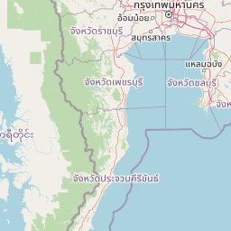
Map view of Kaeng Krachan National Park

Use this park location map to pinpoint Kaeng Krachan National Park in Thailand, understand its exact geographic position, and read its mapped placement within the surrounding landscape more clearly.

Pigeon | © OpenStreetMap contributors

Location context for Kaeng Krachan National Park

Phetchaburi ProvincePrachuap Khiri Khan Province
Park atlas

Compare national parks and trace the regional geography of protected landscapes across the Tenasserim Mountain Range.

Browse National Parks and Protected Areas Surrounding Kaeng Krachan National Park
After exploring Kaeng Krachan National Park, browse other national parks and protected areas that share its regional geography or ecological context. This wider view allows for direct comparison of conservation landscapes, tracing the unique protected terrain across the Tenasserim Mountain Range and adjacent regions.
National parkRatchaburi Province

Chaloem Phrakiat Thai Prachan National Park: Protected Landscape Identity and Geographic Atlas Context

Mapped park boundaries and regional natural terrain discovery.

Chaloem Phrakiat Thai Prachan National Park serves as a key national park entity for structured geographic discovery. This page focuses on its protected landscape, mapped boundaries, and integration within the natural geography of Ratchaburi Province. Explore the park's specific atlas contribution and its place within regional conservation land patterns, providing a factual foundation for landscape context.

Area
328.05 km²
Established
2012
IUCN
II
Climate
Tropical
National parkPrachuap Khiri Khan Province

Khao Sam Roi Yot National Park: A National Park within Prachuap Khiri Khan Province's Geography

Explore the mapped protected landscape and regional context.

Investigate Khao Sam Roi Yot National Park as a distinct protected area and national park entity within the geographic framework of Prachuap Khiri Khan Province. This dedicated page offers insights into its mapped boundaries, regional landscape character, and its contribution to the atlas of protected lands in western Thailand. Understand the park's environmental geography and its specific place within the broader national conservation efforts.

Area
98 km²
Established
1966
IUCN
II
Visitors
164.7K annual
National parkPrachuap Khiri Khan Province

Namtok Huai Yang National Park: Protected Mountain Terrain and Waterfall Atlas

Discover Prachuap Khiri Khan Province's significant natural landscape.

Namtok Huai Yang National Park is a key protected area in Thailand's Prachuap Khiri Khan Province, renowned for its distinctive montane geography shaped by the Tenasserim Hills. This national park offers a detailed view of forest ecosystems, watershed importance, and cascading waterfalls, all presented within a structured atlas framework. Users can explore the park's mapped boundaries and terrain characteristics, gaining a concrete understanding of its geographic significance and natural protected landscape.

Area
161 km²
Established
1991
IUCN
II
Visitors
26.9K annual
National parkPrachuap Khiri Khan Province

Hat Wanakon National Park: Mapped Protected Area within Prachuap Khiri Khan's Geography

Explore protected national park boundaries and regional landscape context.

Hat Wanakon National Park serves as a significant protected landscape entity within the Prachuap Khiri Khan Province region of Thailand. This national park's mapped boundaries offer insight into its territorial extent and its role within the country's network of conservation areas. Exploring this park provides a concrete example of protected land within the varied geography of the Kra Isthmus, enriching your atlas-based understanding of Thailand's natural reserves.

Area
38 km²
Established
1992
IUCN
II
Visitors
43.3K annual
National parkPrachuap Khiri Khan Province

Ao Siam National Park: Protected Landscape and Regional Geography within Thailand

Discover the mapped boundaries and natural terrain of this Thai national park.

Ao Siam National Park is a designated national park in Thailand, located within the Prachuap Khiri Khan Province. This protected landscape offers valuable insights into the regional geography of the Kra Isthmus. Users can explore its mapped boundaries and understand its significance as a natural area within the atlas of Thai protected lands. The park's setting provides a concrete example of protected territory contributing to the region's overall geographic context.

Area
31.94 km²
IUCN
II
Relief
Lowland
Climate
Subtropical
Watercolor illustration of a serene landscape featuring a body of water, distant hills, and green vegetation
National parkKanchanaburi Province

Sai Yok National Park: Protected Landscape Boundaries and Regional Geographic Context

Explore the mapped terrain and park geography within Kanchanaburi.

Sai Yok National Park serves as a vital protected area within Kanchanaburi Province, offering a clear focus for geographic exploration and atlas-based understanding. This entry details the park's specific mapped boundaries and its role within the broader regional landscape context, providing essential data for comprehending its natural geography and conservation significance.

Area
500 km²
Established
1980
IUCN
II
Visitors
67.7K annual
Watercolor painting showing green hills, purple mountains, and a calm water body with sparse vegetation
National parkRayong Province

Khao Laem Ya, Mu Ko Samet National Park: Marine National Park and Protected Island Geography

Coastal terrain and archipelago mapped within Rayong Province.

Delve into Khao Laem Ya, Mu Ko Samet National Park, a significant marine protected area located in Rayong Province, Thailand. This atlas entry highlights the park's archipelago of islands, including Ko Samet, its mainland coastal features like Khao Laem Ya, and the surrounding Gulf of Thailand waters. Understand the park's role in coastal conservation, its mapped marine environments, and its unique blend of terrestrial and aquatic protected landscapes for geographic discovery.

Area
131 km²
Established
1981
IUCN
II
Visitors
1.6M annual
National parkKanchanaburi Province

Khuean Srinagarindra National Park: A Protected Landscape in Kanchanaburi Province's Geography

Explore the mapped terrain and natural context of this national park.

Khuean Srinagarindra National Park stands as a distinct protected landscape within Kanchanaburi Province. This page provides a gateway to understanding its geographic identity, mapped boundaries, and natural terrain characteristics. As a national park, it offers rich opportunities for those seeking to explore the regional geography and protected areas of Thailand through a structured, atlas-focused lens.

Area
1,532 km²
Established
1981
IUCN
II
Visitors
71K annual

Common questions about visiting, size, designation, and location context for Kaeng Krachan National Park

Kaeng Krachan National Park FAQs for park facts, access, geography, and protected area context
Find quick answers about Kaeng Krachan National Park, including protected-area facts, park geography, trail and visitor context, and how the park fits into its surrounding country and regional landscape.
MoriAtlas Explorer

Continue Your Protected Areas Search Across the Global Atlas

Deepen your exploration by continuing the structured search for national parks and protected areas worldwide. Utilize the comprehensive filtering capabilities to compare different conservation landscapes and refine your understanding of global park geography. Discover more about the distribution and characteristics of protected natural areas.

Global natural geography
Kaeng Krachan National Park: Thailand National Park Atlas & Map