
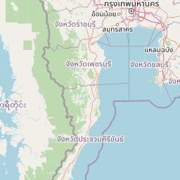
Rivers
Park geography
A comprehensive analysis of terrain elevation, river systems, and forest landscapes
Geographic Profile and Mapped Boundaries of Kaeng Krachan National Park, Thailand
This geographic dataset provides an overview of Kaeng Krachan National Park across Phetchaburi and Prachuap Khiri Khan provinces. It features detailed records of riverine systems, mountain relief reaching 1513 meters in elevation, and the distribution of forest and lacustrine habitats within the 2915 square kilometer boundary.
Related tags
Tropical RainforestUNESCO World Heritage SiteTenasserim MountainsASEAN Heritage ParkMountain Peaks
Thailand's largest national park with World Heritage status protecting vast Tenasserim Range rainforests
Kaeng Krachan National Park
Kaeng Krachan National Park is the largest national park in Thailand, encompassing approximately 2,915 square kilometers of pristine wilderness along the border with Myanmar. Located in Phetchaburi and Prachuap Khiri Khan Provinces, the park occupies the eastern slopes of the Tenasserim Mountain Range, a biodiversity-rich corridor that forms part of a transboundary forest complex connected to Myanmar's Tanintharyi Nature Reserve. The park was established on 12 June 1981 as Thailand's 28th national park and was designated a UNESCO World Heritage Site in July 2021, recognizing its exceptional ecological significance as one of the largest intact forest complexes in mainland Southeast Asia. The landscape features rugged mountain terrain rising to 1,513 meters, with the Pranburi and Phetchaburi rivers originating within its boundaries, the latter dammed to create a 46.5 square kilometer reservoir that has become a signature feature of the park.
- Location
- Thailand
- Park type
- National park
- Established
- 1981
- Area
- 2,915 km²
- Highest point
- 1,513 m
Location overview
Provincial distributions and transboundary borders of the park
Geographic Location and Borders of Kaeng Krachan National Park
Kaeng Krachan National Park sits within Thailand and American Samoa, crossing Phetchaburi and Prachuap Khiri Khan provinces. National records classify the protected wilderness as a transboundary park.
- Countries
- Thailand
- Regions
- Phetchaburi Province, Prachuap Khiri Khan Province
- Primary location
- Phetchaburi Province
- Geographic setting
- Transboundary
Boundary and coordinates
Analyzing the 2,915 square kilometer spatial span and dimensions
Mapping the Spatial Boundaries of Kaeng Krachan National Park
Interactive boundary geometry provides critical spatial context for the protected wilderness. Accompanying metrics define the estimated total area, geographic center, and coordinate span limits.
- Boundary area
- 3,039.9 km²
- Boundary perimeter
- 502.5 km
- Northernmost point
- 13.244° N
- Southernmost point
- 12.4562° N
- Easternmost point
- 99.6895° E
- Westernmost point
- 99.0994° E
- Geographic centre
- 12.8908° N, 99.4061° E
- North–south span
- 87.1 km
- East–west span
- 64.1 km
Elevation and terrain
Mountain relief mapping and recorded natural features
Kaeng Krachan National Park Terrain and Elevation Range
Recorded elevation data shows a high point reaching 1513 meters across the mountain terrain. Accompanying feature cards outline specific rivers, waterfalls, and viewpoints located within the protected area.
- Maximum elevation
- 1,513 m
- Highest point
- 1,513 m
Selected named natural features
Viewpoints
ทะเลหมอกเขาพะเนินทุ่ง
730 m
Streams
แม่น้ำปราณบุรี
Reservoirs
อ่างเก็บน้ำแก่งกระจาน
Streams
ห้วยสะตือ
Waterfalls
น้ำตกป่าละอู
Environmental setting
Tropical forest zones, mountain relief, and major water features across the protected landscape
Kaeng Krachan National Park Environmental Settings and Mapped Habitat Classifications
Recorded landscape features, tropical climate zones, and dominant forest covers frame the physical setting of Kaeng Krachan National Park. Stored environmental categories connect directly to related atlas destinations for structured geographic discovery.
- Relief
- Mountain
- Climate
- Tropical
- Water
- Major water bodies
- Forest cover
- Dense forest cover
Landscape features
Forest · Mountains · Lakes · Rivers
Habitat types
Tropical forest · Montane forest · Lacustrine habitat · Riverine habitat
Park atlas
Compare national parks and trace the regional geography of protected landscapes across the Tenasserim Mountain Range.
Browse National Parks and Protected Areas Surrounding Kaeng Krachan National Park
After exploring Kaeng Krachan National Park, browse other national parks and protected areas that share its regional geography or ecological context. This wider view allows for direct comparison of conservation landscapes, tracing the unique protected terrain across the Tenasserim Mountain Range and adjacent regions.
National parkPrachuap Khiri Khan Province
6.2 km away#1 closest
South

Kui Buri National Park: Protected Mountain Forest and Wildlife Corridor in Thailand
Explore mapped boundaries within Prachuap Khiri Khan Province's natural terrain.
Kui Buri National Park is a vital protected area located in the Tenasserim Hills of Prachuap Khiri Khan Province, Thailand. This national park spans nearly 1,000 square kilometers of mountainous terrain, characterized by extensive dry and moist evergreen forests that create a critical corridor for large mammals, including elephants and tigers. Its designation as a UNESCO World Heritage Site underscores its ecological importance and its role in preserving the region's natural landscapes. Detailed map exploration reveals the park's geographic extent and its contribution to conservation efforts.
- Area
- 969 km²
- Established
- 1999
- IUCN
- II
- Visitors
- 20.7K annual
National parkRatchaburi Province
About 20 km away#2 closest
North
Chaloem Phrakiat Thai Prachan National Park: Protected Landscape Identity and Geographic Atlas Context
Mapped park boundaries and regional natural terrain discovery.
Chaloem Phrakiat Thai Prachan National Park serves as a key national park entity for structured geographic discovery. This page focuses on its protected landscape, mapped boundaries, and integration within the natural geography of Ratchaburi Province. Explore the park's specific atlas contribution and its place within regional conservation land patterns, providing a factual foundation for landscape context.
- Area
- 328.05 km²
- Established
- 2012
- IUCN
- II
- Climate
- Tropical
National parkPrachuap Khiri Khan Province
About 47 km away#3 closest
Southeast
Khao Sam Roi Yot National Park: A National Park within Prachuap Khiri Khan Province's Geography
Explore the mapped protected landscape and regional context.
Investigate Khao Sam Roi Yot National Park as a distinct protected area and national park entity within the geographic framework of Prachuap Khiri Khan Province. This dedicated page offers insights into its mapped boundaries, regional landscape character, and its contribution to the atlas of protected lands in western Thailand. Understand the park's environmental geography and its specific place within the broader national conservation efforts.
- Area
- 98 km²
- Established
- 1966
- IUCN
- II
- Visitors
- 164.7K annual
National parkPrachuap Khiri Khan Province
87 km away#4 closest
South
Hat Wanakon National Park: Mapped Protected Area within Prachuap Khiri Khan's Geography
Explore protected national park boundaries and regional landscape context.
Hat Wanakon National Park serves as a significant protected landscape entity within the Prachuap Khiri Khan Province region of Thailand. This national park's mapped boundaries offer insight into its territorial extent and its role within the country's network of conservation areas. Exploring this park provides a concrete example of protected land within the varied geography of the Kra Isthmus, enriching your atlas-based understanding of Thailand's natural reserves.
- Area
- 38 km²
- Established
- 1992
- IUCN
- II
- Visitors
- 43.3K annual
National parkPrachuap Khiri Khan Province
About 93 km away#5 closest
South
Namtok Huai Yang National Park: Protected Mountain Terrain and Waterfall Atlas
Discover Prachuap Khiri Khan Province's significant natural landscape.
Namtok Huai Yang National Park is a key protected area in Thailand's Prachuap Khiri Khan Province, renowned for its distinctive montane geography shaped by the Tenasserim Hills. This national park offers a detailed view of forest ecosystems, watershed importance, and cascading waterfalls, all presented within a structured atlas framework. Users can explore the park's mapped boundaries and terrain characteristics, gaining a concrete understanding of its geographic significance and natural protected landscape.
- Area
- 161 km²
- Established
- 1991
- IUCN
- II
- Visitors
- 26.9K annual
National parkKanchanaburi Province
108 km away#6 closest
North
Erawan National Park: National Park Protected Landscape and Geographic Atlas Context
Explore the mapped terrain and protected natural features.
Erawan National Park stands as a protected national park entity within the geography of Kanchanaburi Province, Thailand. This page provides detailed geographic information, focusing on its mapped boundaries and the natural landscape it encompasses. It serves as a vital atlas resource for understanding the park's protected area status and its specific contribution to the region's natural geography, offering insights for landscape exploration.
- Area
- 550 km²
- Established
- 1975
- IUCN
- II
- Visitors
- 519.2K annual

National parkKanchanaburi Province
About 138 km away#7 closest
Northwest
Sai Yok National Park: Protected Landscape Boundaries and Regional Geographic Context
Explore the mapped terrain and park geography within Kanchanaburi.
Sai Yok National Park serves as a vital protected area within Kanchanaburi Province, offering a clear focus for geographic exploration and atlas-based understanding. This entry details the park's specific mapped boundaries and its role within the broader regional landscape context, providing essential data for comprehending its natural geography and conservation significance.
- Area
- 500 km²
- Established
- 1980
- IUCN
- II
- Visitors
- 67.7K annual
National parkPrachuap Khiri Khan Province
About 138 km away#8 closest
South
Ao Siam National Park: Protected Landscape and Regional Geography within Thailand
Discover the mapped boundaries and natural terrain of this Thai national park.
Ao Siam National Park is a designated national park in Thailand, located within the Prachuap Khiri Khan Province. This protected landscape offers valuable insights into the regional geography of the Kra Isthmus. Users can explore its mapped boundaries and understand its significance as a natural area within the atlas of Thai protected lands. The park's setting provides a concrete example of protected territory contributing to the region's overall geographic context.
- Area
- 31.94 km²
- IUCN
- II
- Relief
- Lowland
- Climate
- Subtropical
MoriAtlas Explorer
Continue exploring the geography of Kaeng Krachan National Park and Phetchaburi Province
Deepen your understanding of Kaeng Krachan National Park by examining its precise geographic setting and protected landscape characteristics. This atlas-focused approach reveals the mapped terrain and regional context, allowing for structured discovery of Thailand's natural areas. Continue to browse the mapped protected areas and their unique geographic attributes.
Browse next
Global natural geography
Explore related park routes
Explore MoriAtlas Global ParksBrowse All MoriAtlas ParksGlobal Park Map DiscoveryMoriAtlas: Browse All CountriesBrowse All MoriAtlas ContinentsNational Park Environment AtlasGrand Canyon National Park AtlasYellowstone National Park AtlasYosemite National Park Atlas and GeographySerengeti National Park AtlasGalápagos National Park Protected LandscapeBanff National Park Geography and AtlasKruger National Park Atlas EntryUluṟu-Kata Tjuṯa National Park AtlasExplore Uluru-Kata Tjuta National Park GeographyPlitvice Lakes National Park AtlasFiordland National Park Protected LandscapeGreat Smoky Mountains National Park AtlasAfghanistan National Parks and Protected AreasAlbania National Parks and Protected AreasAlgeria National Parks and Protected AreasAmerican Samoa National Parks and Protected AreasAndorra National Parks and Protected AreasAngola National Parks and Protected AreasAntarctica National Parks and Protected AreasAntigua and Barbuda Park List