

Mori Atlas logo
National parkKaeng Tana National Park

Explore the mapped geography and protected landscape boundaries of Kaeng Tana National Park.

Kaeng Tana National Park: National Park in Ubon Ratchathani Province, Thailand

Kaeng Tana National Park represents a significant protected natural area within Ubon Ratchathani Province, Thailand. This page serves as an atlas entry point for understanding the park's geographic identity, its mapped boundaries, and its place within the regional landscape. Discover the protected land's natural terrain context, helping to orient your exploration of Thailand's national parks and conservation areas through a geographic lens.

riverine protected areadeciduous forestisland ecosystemsrapids and waterfallsarchaeological sitenortheastern Thailand

Kaeng Tana National Park

National park

Park overview

Structured park overview, official facts, and landscape profile for Kaeng Tana National Park

Kaeng Tana National Park park facts, protected area profile, and essential visitor context
Review the core facts for Kaeng Tana National Park, including designation, size, terrain, visitor scale, habitats, and operating context in one park-focused overview.

About Kaeng Tana National Park

Kaeng Tana National Park occupies a significant position in northeastern Thailand's protected area network, spanning portions of Khong Chiam and Sirindhorn Districts in Ubon Ratchathani Province. The park's landscape is characterized by a series of plateaux and gently undulating hills, with the terrain rising from approximately 200 meters at the valley floors to 543 meters at Ban Tad, the highest peak within the park boundaries. Two major river systems define the northern edge of the protected area: the Mun River, which flows through the heart of the park, and the Mekong River, which forms part of the international boundary with Laos. The park derives its name from the prominent rapids that have historically presented dangers to local water travelers, with local tradition holding that the original name "Kaeng Mana" (meaning rapids of death) reflected the hazardous conditions and tragic accidents that occurred in the swift-flowing channels. The park was officially established in 1981 and has since become an important conservation area for the region's deciduous forest ecosystems and riverine biodiversity. Visitors are drawn to the park's natural attractions, which include the iconic rapids, the island of Don Tana, and several waterfalls accessible from the park headquarters.

Quick facts and research context for Kaeng Tana National Park

Kaeng Tana National Park covers 80 square kilometres in Ubon Ratchathani Province, northeastern Thailand. The terrain consists of highland plateaux and hills with an average elevation of 200 meters, rising to 543 meters at Ban Tad peak. The Mun River flows through the park, which also borders the Mekong River to the north. The park was established in 1981 and receives approximately 31,170 visitors annually. The protected area features the distinctive Kaeng Tana rapids and Don Tana island in the middle of the Mun River.

Park context

Deeper park guide and search-rich context for Kaeng Tana National Park

Kaeng Tana National Park history, landscape, wildlife, and travel context
Explore Kaeng Tana National Park through its history, landscape character, ecosystems, wildlife, conservation priorities, cultural context, and seasonal travel timing in a structured park guide built for atlas discovery and search intent.

Why Kaeng Tana National Park stands out

Kaeng Tana National Park is best known for its dramatic riverine landscape featuring the largest rapids on the Mun River and the prominent Don Tana island. The rapids contain a massive sandstone boulder that divides the river into two streams, a striking geological feature visible to visitors. The park also preserves significant archaeological remains, including a stone inscription and Lingam base from the 7th-8th century now housed in the Ubon Ratchathani National Museum. The combination of river scenery, riparian forest habitats, and cultural heritage makes this park distinctive among Thailand's northeastern protected areas.

Kaeng Tana National Park history and protected-area timeline

Kaeng Tana National Park was officially established on 13 July 1981, making it one of the later additions to Thailand's national park system during the expansion of protected areas in the latter half of the twentieth century. The establishment of the park reflected growing recognition of the ecological and scenic value of Thailand's northeastern river landscapes. Prior to formal protection, the area around the Kaeng Tana rapids and Don Tana had long served as a navigation point and fishing ground for local communities. Archaeological discoveries within the park boundaries, particularly the stone inscription and Lingam base from the 7th-8th century found at Tham Phra cave, indicate that the area held cultural and spiritual significance for earlier civilizations. The Thai name "Tana" is believed to derive from "Mana" in local usage, reflecting the historical perception of the rapids as dangerous. The park's management falls under the jurisdiction of Thailand's National Park, Wildlife and Plant Conservation Department, which administers protected areas throughout the kingdom.

Kaeng Tana National Park landscape and geographic character

The terrain of Kaeng Tana National Park consists primarily of highland and plateau landscapes with undulating hills. The elevation ranges from approximately 200 meters in the valley areas to 543 meters at Ban Tad peak, the highest point within the park. The Mun River bisects the protected area, creating the distinctive Kaeng Tana rapids, which represent the largest rapid system on the river. At the center of the rapids, a massive sandstone boulder splits the river into two distinct channels. The Don Tana island rises in the middle of the river, measuring approximately 450 meters in width and 700 meters in length. The park's terrain also includes cliff formations along the Mun River, particularly along the Namtok Rak Sai Nature Trail, where visitors can observe various geological features. The landscape supports a mosaic of forest types, with deciduous forest dominating the upland areas and dry evergreen forest concentrated along stream corridors and in the Don Tana area.

Kaeng Tana National Park ecosystems, habitats, and plant life

Kaeng Tana National Park protects important forest ecosystems typical of northeastern Thailand'sxeric landscape. The predominant forest type is deciduous dipterocarp forest, characterized by species such as Shorea obtusa, Shorea siamensis, and Dipterocarpus obtusifollus, which dominate the drier upland areas. This forest type covers approximately 84 percent of the park's total area. Dry evergreen forest occurs in more restricted locations, particularly along major streams and around the Don Tana area, where moisture conditions support species like Eugenia cumini, Pterocarpus macrocarpus, and Xylia kerrii. The park also contains areas of grassland and bamboo growth. The river systems support distinctive riparian habitats, with the confluence of the Mun and Mekong Rivers creating productive aquatic environments. The park sits within Thailand's monsoon climate zone, experiencing three distinct seasons: a warm season from February to May, a cool dry season from October to January, and a rainy season from June to September. Average temperatures range from 18-22 degrees Celsius in the cool season to 30-35 degrees during the warm period.

Kaeng Tana National Park wildlife and species highlights

The wildlife community of Kaeng Tana National Park reflects the diverse habitats provided by its forest and riverine environments. Mammal species present in the park include wild pigs, barking deer, various civet species, macaques, and gibbons. The eastern portions of the park, particularly around the Ban Tad mountain range, support populations of larger mammals including deer, wild boars, and small carnivores. The avian fauna is notably diverse, with surveys documenting 48 bird species within the park boundaries. Notable bird species include the red-backed hawk, great barbet, brown hawk-owl, swallows, warblers, flycatchers, and sunbirds. The river systems are exceptionally rich in fish biodiversity, with 139 fish species recorded across 23 families. The fish community includes representatives of the carp family (68 species), catfish families, and specialized species such as the Mekong pangasiid and other locally endemic forms. Reptiles including monitors, geckoes, pythons, and cobras are also present in the park.

Kaeng Tana National Park conservation status and protection priorities

Kaeng Tana National Park represents an important protected area for the conservation of northeastern Thailand's deciduous forest ecosystems and riverine biodiversity. As an IUCN Category II protected area, the park is managed primarily for ecosystem conservation while allowing for sustainable recreation and environmental education. The park protects significant populations of fish species in the Mun and Mekong River systems, which are vital for maintaining genetic diversity and supporting local fishing communities. The riparian forests along the river corridors serve as important corridors for wildlife movement and provide habitat for species dependent on water resources. The archaeological resources, including the 7th-8th century stone inscription, add cultural heritage value to the park's conservation mandate. Management focuses on balancing visitor access with habitat protection, particularly around the sensitive rapids and island ecosystems.

Kaeng Tana National Park cultural meaning and human context

The area surrounding Kaeng Tana National Park holds significance in local tradition and historical memory. The name "Tana" derives from "Mana," reflecting the historical perception of the rapids as dangerous waters where travelers and fishermen frequently met with accidents. The park area has been associated with traditional riverine activities including fishing and navigation along the Mun River, which has served as a transportation corridor between Thailand and Laos. Archaeological discoveries at Tham Phra cave, including a stone inscription and Lingam base from the 7th-8th century, indicate that the area held religious and spiritual significance for earlier Khmer-influenced civilizations. These artifacts are now preserved in the Ubon Ratchathani National Museum. The local communities in Khong Chiam and Sirindhorn Districts maintain connections to the landscape through traditional land use practices and ongoing cultural associations with the river.

Top sights and standout views in Kaeng Tana National Park

Kaeng Tana National Park offers several distinctive attractions that set it apart among Thailand's protected areas. The Kaeng Tana rapids represent the largest rapid system on the Mun River, with a massive sandstone boulder dividing the flow into two channels and creating a dramatic natural feature. Don Tana island in the middle of the river provides a unique island landscape within a major river system. The Namtok Rak Sai Nature Trail follows the cliff line along the Mun River for one kilometer, passing through lush vegetation including lichens, mosses, and ferns. The Tham Phra archaeological site contains evidence of ancient religious use dating to the 7th-8th century. Namtok Tat Ton waterfall provides another natural attraction accessible from Highway 2173. The park's location at the confluence of the Mun and Mekong Rivers positions it at an important ecological and geographical junction.

Best time to visit Kaeng Tana National Park

The optimal time to visit Kaeng Tana National Park is during the late rainy season, from approximately September to November, when weather conditions are most comfortable for outdoor exploration. During this period, temperatures range from 25 to 30 degrees Celsius, and the rainfall creates lush vegetation throughout the park. The landscapes are refreshed by seasonal rains, and many plant species come into flower, enhancing the scenic appeal of trails and viewpoints. The cool season from October through January offers pleasant temperatures between 18 and 22 degrees Celsius, though conditions are drier. The warm season from February to May can bring temperatures up to 35 degrees, which may limit outdoor activities. The rainy season from June to September brings frequent downpours but also ensures the waterfalls are flowing at their fullest.

Park location guide

Geography guide, regional context, and park location map for Kaeng Tana National Park

Kaeng Tana National Park park geography, regions, and map view in Thailand
Understand where Kaeng Tana National Park sits in Thailand through a broader geographic reading of the surrounding landscape, nearby location context, and its mapped position within the national park landscape.

How Kaeng Tana National Park fits into Thailand

Thailand is a Southeast Asian nation formerly called Siam, located in mainland Southeast Asia. It operates as a unitary parliamentary constitutional monarchy under King Vajiralongkorn. The country borders Myanmar, Laos, Cambodia, and Malaysia, with maritime boundaries involving Vietnam, Indonesia, and India. Thailand has a population of nearly 66 million and covers approximately 513,120 km². Historically, the Sukhothai Kingdom marks the beginning of Thai history, followed by the powerful Ayutthaya Kingdom.

Wider geography shaping Kaeng Tana National Park in Thailand

Thailand occupies mainland Southeast Asia with borders to Myanmar (west/northwest), Laos (east/northeast), Cambodia (southeast), and Malaysia (south). The country has coastline along the Gulf of Thailand to the southeast and the Andaman Sea to the southwest. The territory covers approximately 513,120 km².

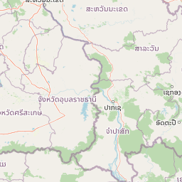
Map view of Kaeng Tana National Park

Use this park location map to pinpoint Kaeng Tana National Park in Thailand, understand its exact geographic position, and read its mapped placement within the surrounding landscape more clearly.

Pigeon | © OpenStreetMap contributors

Location context for Kaeng Tana National Park

Ubon Ratchathani Province
Park atlas

Browse adjacent protected landscapes and trace the regional spread of riverine and forest ecosystems beyond Kaeng Tana.

Explore National Parks and Protected Areas near Kaeng Tana National Park, Thailand
Explore other national parks and protected areas situated geographically close to Kaeng Tana National Park, tracing their mapped locations across northeastern Thailand. This extended atlas view allows for deeper comparison of diverse riverine protected landscapes and adjacent forest ecosystems within their regional context.
National parkUbon Ratchathani Province

Pha Taem National Park: Mapped Protected Landscape in Ubon Ratchathani

National park exploration and geographic context

Pha Taem National Park serves as a distinct protected area within Ubon Ratchathani Province, offering a focused lens for geographic discovery. Understand its specific location, mapped boundaries, and the surrounding natural landscape context that defines this national park. This entry supports detailed atlas exploration of Thailand's protected territories.

Area
340 km²
Established
1991
IUCN
II
Visitors
180.2K annual
National parkSisaket Province

Khao Phra Wihan National Park: Protected Landscape and Archaeological Atlas Gateway

Explore dramatic red sandstone cliffs and historic Khmer ruins.

Khao Phra Wihan National Park in Sisaket Province, Thailand, is a protected landscape distinguished by its dramatic Pha Mo I Daeng red sandstone cliff and its role as a gateway to significant Khmer archaeological sites. This national park offers a deep dive into the region's unique geography, featuring rugged terrain, distinctive forest ecosystems, and prehistoric rock art. As a key entry point for understanding the Preah Vihear Temple's context, the park provides rich material for atlas-based exploration of border landscapes and historical terrain.

Area
130 km²
Established
1998
IUCN
II
Visitors
202.6K annual
National parkAmnat Charoen Province

Phu Sa Dok Bua National Park: National Park with Mapped Protected Boundaries

Explore protected landscapes in Amnat Charoen Province, Thailand.

Discover Phu Sa Dok Bua National Park, a designated national park situated within the geographic context of Amnat Charoen Province. This profile focuses on the park's protected area identity and its mapped boundaries, offering essential geographic information for atlas-based exploration and understanding its role within Thailand's conservation landscape.

Area
231 km²
Established
1992
IUCN
II
Visitors
1.8K annual
National parkMukdahan Province

Phu Pha Thoep National Park: Mukdahan Province Protected National Park Geography

Explore its mapped protected landscape and regional context.

Phu Pha Thoep National Park is a designated national park in Thailand's Mukdahan Province, offering a distinct focus for geographic exploration. This resource provides detailed insights into its protected landscape, outlining mapped park boundaries and its integration within the regional geography. Understand the park's specific natural terrain and its value for structured atlas-style discovery, moving beyond simple location data to grasp its protected area significance.

Area
48 km²
IUCN
II
Visitors
47.6K annual
Relief
Upland
National parkRatanakiri province

Virachey National Park: Cambodia's Vast Highland Protected Landscape in Ratanakiri

Explore its remote montane forest ecosystems and diverse terrain.

Virachey National Park, Cambodia's largest national park, offers a profound glimpse into one of mainland Southeast Asia's last great wildernesses. Spanning remote highland terrain in Ratanakiri province, it features dramatic elevation changes from 400 to 1,500 meters, supporting diverse ecosystems including dense lowland forests, unique montane cloud forests, and upland savannahs. Its recognition as an ASEAN Heritage Park underscores its critical regional conservation value, making it a significant destination for understanding protected landscapes and their geographic context.

Area
3,380.57 km²
Established
1993
IUCN
II
Relief
Mountain
National parkRatanakiri province

Veun Sai, Siem Pang National Park: Northeastern Cambodia's Protected Lowland Forest Landscape

Mapped Boundaries and Primate Conservation Habitat

Veun Sai, Siem Pang National Park in Cambodia's Ratanakiri province is a vital protected area featuring expansive lowland evergreen and semi-evergreen forests. Its designation as a national park underscores its role in safeguarding critical habitat for diverse primate populations, notably the endangered Northern buffed-cheeked gibbon. The park's geography, characterized by gentle terrain and extensive forest cover, makes it a significant component of the region's biodiversity corridor and a key site for understanding Cambodia's natural landscapes.

Area
574.69 km²
Established
2016
IUCN
II
Relief
Lowland
National parkSiem Reap Province

Phnom Kulen National Park: Protected Highland Landscape and Khmer Empire Origins in Siem Reap

Explore ancient Khmer sites and natural terrain within this Cambodian national park.

Phnom Kulen National Park offers a unique glimpse into Cambodia's geographic and historical richness. As a protected national park in Siem Reap Province, it preserves a distinct highland landscape characterized by sandstone formations, evergreen forests, and sacred sites. Discover the mapped boundaries of this important conservation area, trace the historical significance of the Khmer Empire's origins, and explore the natural terrain that defines this culturally significant region.

Area
373.76 km²
Established
1993
IUCN
II
Relief
Mountain
National parkSakon Nakhon Province

Phu Pha Yon National Park: Protected Landscape and Regional Geography in Sakon Nakhon Province

Explore the mapped boundaries and natural terrain of this Thai national park.

Phu Pha Yon National Park, situated in Sakon Nakhon Province, is a protected national park offering a focused point for geographic exploration. This park entity serves as a component of Thailand's broader protected area network, with its mapped boundaries and natural landscape providing essential context for regional geography studies. Understanding Phu Pha Yon National Park through its geographic setting and protected status enhances atlas-based discovery and appreciation of its place within the Khorat Plateau.

Area
829 km²
Established
1988
IUCN
II
Visitors
5K annual

Common questions about visiting, size, designation, and location context for Kaeng Tana National Park

Kaeng Tana National Park FAQs for park facts, access, geography, and protected area context
Find quick answers about Kaeng Tana National Park, including protected-area facts, park geography, trail and visitor context, and how the park fits into its surrounding country and regional landscape.
MoriAtlas Explorer

Continue Your Protected Areas Search Across the Global Atlas

Deepen your exploration by continuing the structured search for national parks and protected areas worldwide. Utilize the comprehensive filtering capabilities to compare different conservation landscapes and refine your understanding of global park geography. Discover more about the distribution and characteristics of protected natural areas.

Global natural geography
