Mori Atlas logo
National parkPáirc Náisiúnta na Mara

Explore the mapped boundaries and regional setting of this protected area in Southwest Ireland.

Páirc Náisiúnta na Mara National Park: Protected Landscape and Geographic Context in County Kerry

Páirc Náisiúnta na Mara National Park serves as a key protected landscape within County Kerry, Ireland. As part of the Southwest Ireland atlas, this designation highlights its significance for regional geography and mapped natural areas. Users can explore the park's distinct protected-area identity and its place within the broader terrain of the Iveragh Peninsula, contributing to a structured understanding of Ireland's natural heritage.

Marine protected areaAtlantic coastNational parkIsland ecosystemsSeabird coloniesMountain landscapes
Stylized illustration of a green mountain with rocky slopes, a winding trail, blue ocean, and partly cloudy sky

Páirc Náisiúnta na Mara

National park

Park overview

Structured park overview, official facts, and landscape profile for Kerry Seas National Park

Kerry Seas National Park park facts, protected area profile, and essential visitor context
Review the core facts for Kerry Seas National Park, including designation, size, terrain, visitor scale, habitats, and operating context in one park-focused overview.

About Kerry Seas National Park

Kerry Seas National Park represents a transformative approach to conservation in Ireland, establishing the country's first primarily marine-focused national park and its largest protected area overall. The park's territory spans the two great peninsulas of County Kerry, the Dingle Peninsula to the north and the Iveragh Peninsula to the south, extending westward into the Atlantic to encompass offshore islands and their surrounding waters. This coastal and marine focus addresses a significant gap in Ireland's protected areas network, which has historically emphasized terrestrial environments over marine ecosystems.

The park's establishment in April 2024 brought together numerous existing protected elements under unified national park management. These include special areas of conservation, nature reserves, and heritage sites that previously operated under separate designations. The integration of Skellig Michael, a global cultural landmark, within the park framework elevates its international significance beyond typical national park designations. The marine component encompasses approximately 70,000 acres when combined with terrestrial areas, creating a comprehensive conservation zone that addresses both above-water and below-water ecosystems.

The park's landscape character is defined by the dramatic intersection of Atlantic coastline with mountainous terrain. The Dingle Peninsula presents a landscape of steep cliffs, isolated beaches, and the distinctive sandstone formations of Mount Brandon, while the Iveragh Peninsula features the famous Ring of Kerry scenic route alongside offshore islands that support significant seabird populations. This combination of terrestrial mountain scenery with marine environments and island ecosystems creates a diverse protected area that spans multiple habitat types.

Quick facts and research context for Kerry Seas National Park

Kerry Seas National Park occupies the westernmost coastline of Ireland in County Kerry, stretching across the Dingle and Iveragh Peninsulas into the Atlantic. As Ireland's largest national park at roughly 70,000 acres, it combines extensive marine waters with coastal and terrestrial landscapes. The park incorporates diverse protected elements including the Blasket Islands, Mount Brandon nature reserve, the Conor Pass road corridor, Inch dunes, and the Skellig Islands. Its marine designation emphasizes protection of Atlantic ecosystems, seabird colonies, and coastal habitats. The park's establishment in 2024 represents a significant expansion of Ireland's national park system, adding its first primarily marine-based protected area.

Park context

Deeper park guide and search-rich context for Kerry Seas National Park

Kerry Seas National Park history, landscape, wildlife, and travel context
Explore Kerry Seas National Park through its history, landscape character, ecosystems, wildlife, conservation priorities, cultural context, and seasonal travel timing in a structured park guide built for atlas discovery and search intent.

Why Kerry Seas National Park stands out

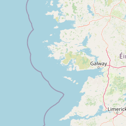
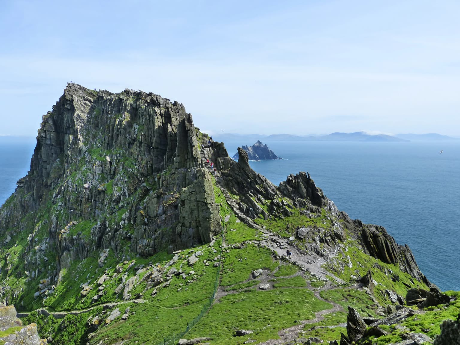
Kerry Seas National Park is best known for its extraordinary concentration of protected landscapes and cultural sites along Ireland's wild Atlantic coast. The Skellig Islands, particularly Skellig Michael with its sixth-century monastic settlement, represent one of Ireland's most significant archaeological treasures and a UNESCO World Heritage Site. The park protects the Blasket Islands, a chain of offshore islands that are vital seabird nesting colonies and notable for their ecological isolation. The Conor Pass road through the An Abha Mhór river valley offers one of Ireland's most spectacular mountain road journeys, while Mount Brandon provides the highest peak in the range. The combination of World Heritage significance, exceptional coastal scenery, marine biodiversity, and the park's status as Ireland's largest protected area defines its distinctive character.

Rugged rocky island with green vegetation and a narrow path leading to the summit, with ocean and distant islands in the background
Skellig Michael, a rugged rocky island with lush green slopes and a narrow path leading to the summit, overlooking the ocean

Kerry Seas National Park history and protected-area timeline

Kerry Seas National Park was formally announced by the Irish government in April 2024, representing the most significant expansion of Ireland's national park system in recent decades. The establishment of this park marked a deliberate shift toward marine conservation within Ireland's protected area framework, addressing the underrepresentation of marine environments in the country's national park network. Prior to this announcement, the areas now incorporated within the park existed under various protection designations, including special areas of conservation under European Union nature directives, nature reserves, and UNESCO World Heritage status for Skellig Michael.

The creation of Kerry Seas National Park consolidated these existing protections while adding the national park designation that provides enhanced management framework and public access provisions. The decision to establish the park reflected growing recognition of the ecological importance of Ireland's Atlantic coastal waters and the need for integrated management of marine and terrestrial environments. The park's announcement was accompanied by commitments to develop management plans that balance conservation objectives with sustainable public enjoyment of the area's natural and cultural resources. As a recently established park, its operational history is limited to the months following its formal designation.

Kerry Seas National Park landscape and geographic character

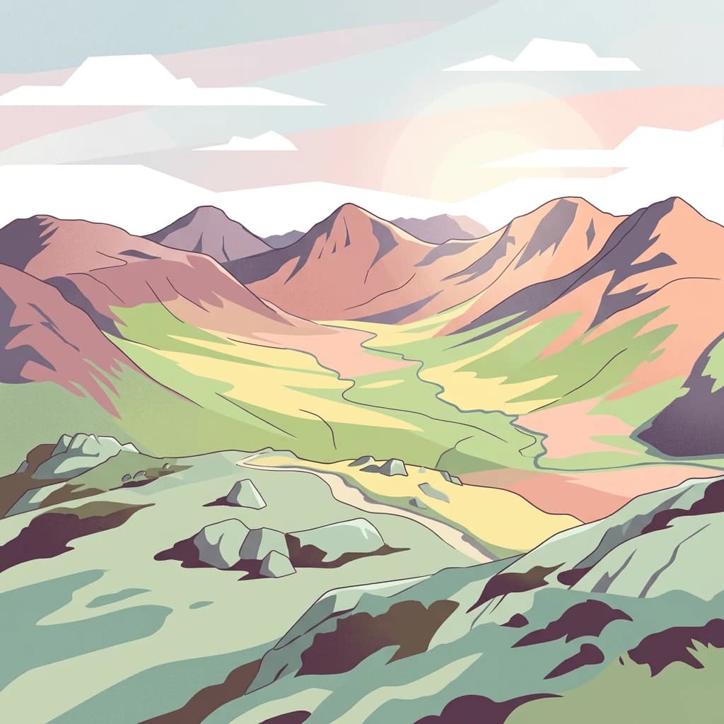
The landscape of Kerry Seas National Park encompasses an extraordinary diversity of terrain shaped by the relentless interaction of Atlantic weather systems with County Kerry's mountainous coastline. The Dingle Peninsula presents a landscape dominated by the Brandon range, with Mount Brandon rising to over 900 meters as the highest peak in the area. The Conor Pass road traverses the An Abha Mhór river valley, climbing through terrain that exemplifies the dramatic mountain-to-sea transitions characteristic of this coast. Rocky cliffs, isolated coves, and dune systems along the peninsula's western edge characterize the coastal margins.

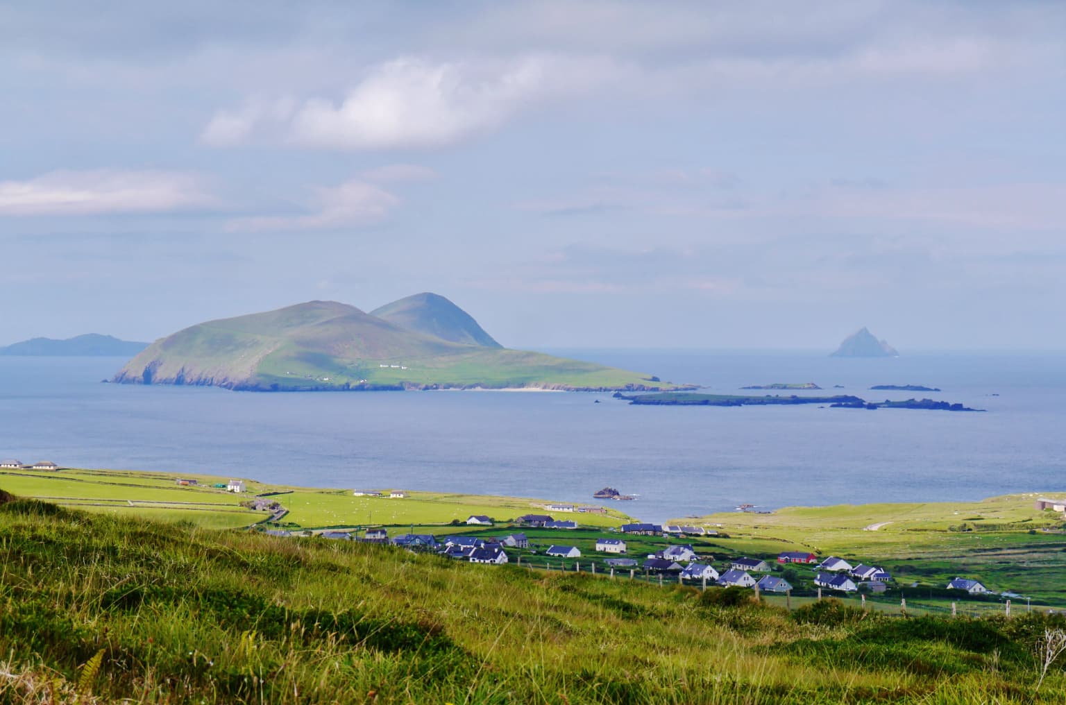
The Iveragh Peninsula's landscape is equally dramatic, featuring the famous Ring of Kerry scenic drive that passes through terrain of mountains, lakes, and coastal viewpoints. Offshore, the Skellig Islands rise dramatically from the Atlantic, their jagged rock stacks supporting nesting seabirds and the ancient monastic structures of Skellig Michael. The Blasket Islands, visible from the Dingle Peninsula's western edge, represent remnant landforms that mark the edge of continental Europe into the Atlantic. The park also includes low-lying dune areas at Inch and the cliff-dominated sections of Kerry Head, creating a landscape that ranges from mountain peaks to wave-battered islands and sheltered sand dunes.

Coastal landscape with green fields, scattered buildings, a large island in the sea, and smaller islands in the distance under a partly cloudy sky
Scenic coastal view of the Dingle Peninsula with rolling green fields, small settlements, and distant islands under a partly cloudy sky

Kerry Seas National Park ecosystems, habitats, and plant life

The nature of Kerry Seas National Park reflects the ecological richness of Ireland's Atlantic boundary, where marine and terrestrial ecosystems intersect in complex patterns. The park's marine component encompasses coastal waters, tidal zones, and the waters surrounding offshore islands, supporting communities of fish, marine mammals, and invertebrate species adapted to North Atlantic conditions. The Blasket Islands and Skellig Islands serve as critical seabird nesting sites, with populations of gulls, puffins, gannets, and other species that depend on these isolated offshore habitats for breeding success.

Terrestrial habitats within the park range from mountain heath and grassland on the slopes of Mount Brandon to dune systems and coastal grasslands. The variety of habitats reflects the park's extent across multiple ecological zones, from exposed coastal cliffs to sheltered river valleys. The existing designations of special area of conservation applied to parts of the park indicate the presence of habitats and species of European conservation importance, though the specific ecological characteristics require detailed field survey for complete documentation. As a newly established park, comprehensive ecological assessment of all components continues as management plans develop.

Kerry Seas National Park wildlife and species highlights

Wildlife in Kerry Seas National Park is concentrated in the offshore islands and coastal waters that form the park's marine core. The Skellig Islands and Blasket Islands support some of Ireland's most important seabird colonies, with species including Atlantic puffins, northern gannets, and various gull species nesting on the cliff faces and grass-covered slopes. These islands provide critical breeding habitat in an area where the North Atlantic's rich waters support abundant food sources for seabirds during the summer months.

Marine wildlife in the park's waters includes species common to the Celtic Sea and Atlantic approaches to Ireland's coast. The coastal cliffs provide nesting opportunities for seabirds, while the surrounding waters support fish species that form the base of the marine food web. The park's terrestrial wildlife includes species typical of Ireland's western coastal mountains and grasslands, though detailed species inventories for the newly established park remain in development. The combination of island seabird colonies, marine waters, and coastal habitats creates a wildlife profile that emphasizes seabirds and marine species as the most notable fauna within the protected area.

Kerry Seas National Park conservation status and protection priorities

The establishment of Kerry Seas National Park represents a significant advance in Ireland's conservation framework, particularly for marine environments that have been underrepresented in the country's protected area network. The park's designation brings coordinated management to a constellation of previously separate protected areas, creating an integrated conservation approach that addresses both terrestrial and marine ecosystems. The inclusion of special areas of conservation within the park framework provides connection between European Union nature protection directives and national park management.

The marine focus of this park addresses a recognized gap in Irish conservation, as previous national parks emphasized terrestrial environments. By incorporating approximately 70,000 acres of combined land and sea, the park creates a conservation zone that can address ecosystem-level management rather than protecting individual habitats in isolation. The presence of Skellig Michael within the park also demonstrates how cultural heritage can be integrated with natural conservation, creating a model for landscape-scale protection that encompasses both ecological and historical values.

Kerry Seas National Park cultural meaning and human context

The cultural context of Kerry Seas National Park is profoundly shaped by the presence of Skellig Michael, a small island whose monastic settlement dates to the sixth century and represents one of the earliest examples of Christian monastic organization in Ireland. The beehive cells, oratories, and other structures built by monks on this isolated Atlantic island have survived for over fourteen centuries, earning UNESCO World Heritage status as one of Ireland's most significant archaeological landscapes. The monastic tradition on Skellig Michael reflected the early medieval preference for remote, coastal locations as sites of spiritual retreat from the secular world.

Beyond Skellig Michael, the park's cultural landscape includes the Blasket Islands, whose small communities maintained Irish language and traditional culture into the twentieth century before voluntary evacuation in the 1950s. The tetrapod trackway on Valentia Island represents some of the earliest evidence of vertebrate land colonization, providing scientific and cultural significance. The broader landscape of County Kerry contains rich traditions of Irish language, music, and storytelling that continue in the surrounding communities, creating a cultural context where the park's protected landscapes exist within an ongoing living culture rather than as isolated heritage sites divorced from contemporary community life.

Top sights and standout views in Kerry Seas National Park

Kerry Seas National Park brings together an unparalleled concentration of Ireland's natural and cultural landmarks within a single protected area framework. The Skellig Islands and Skellig Michael represent the park's most internationally recognized feature, combining World Heritage status with exceptional coastal scenery and seabird colonies. The Blasket Islands offer remote island wilderness with rich ecological and cultural significance. The Conor Pass road through the An Abha Mhór valley provides one of Ireland's most celebrated scenic drives, while Mount Brandon offers mountain walking in terrain of geological and cultural importance. The park's establishment as Ireland's first primarily marine national park marks a new chapter in Irish conservation, expanding protection into theAtlantic waters that define the country's western edge. The combination of island ecosystems, mountain landscapes, coastal terrain, and ancient cultural sites makes this park distinctive among Ireland's protected areas.

Best time to visit Kerry Seas National Park

The best time to visit Kerry Seas National Park depends on the specific experiences sought, though the summer months of June through August offer the most reliable conditions for outdoor exploration and wildlife viewing. Seabird colonies on the offshore islands are most active during the breeding season, with puffins and other species visible from boat excursions that operate from the mainland during summer. The longer daylight hours allow extended exploration of the park's extensive trail networks and scenic routes. However, this is also the busiest period, particularly around popular locations like the Ring of Kerry and areas associated with Skellig Michael access.

The shoulder seasons of spring and autumn offer advantages for visitors seeking fewer crowds while maintaining reasonable weather conditions. The park's landscapes take on different characters across seasons, with spring bringing wildflower displays in coastal grasslands and autumn offering atmospheric conditions as Atlantic storms begin to sweep across the coast. Winter visits provide the opportunity to experience the park's wild character in more challenging conditions, though some facilities and boat services may have reduced operations. The park's marine component and coastal locations mean that weather conditions can change rapidly throughout the year, and visitors should be prepared for the variable conditions characteristic of Ireland's Atlantic coast.

Park location guide

Geography guide, regional context, and park location map for Kerry Seas National Park

Kerry Seas National Park park geography, regions, and map view in Ireland
Understand where Kerry Seas National Park sits in Ireland through a broader geographic reading of the surrounding landscape, nearby location context, and its mapped position within the national park landscape.

How Kerry Seas National Park fits into Ireland

Ireland is an island in the North Atlantic, geologically part of the British Isles. Politically, the island is split between the Republic of Ireland (a sovereign state and EU member) and Northern Ireland (part of the UK). The island has a population of approximately 7.2 million people and is known for its lush landscape, Celtic heritage, and literary culture.

Wider geography shaping Kerry Seas National Park in Ireland

Ireland is an island in the North Atlantic Ocean, separated from Great Britain to the east by the North Channel, Irish Sea, and St George's Channel. The island forms part of the British Isles archipelago. The terrain consists of low-lying mountains surrounding a central plain, with the highest point being Carrauntoohil at 1,041 metres. The coastline stretches approximately 7,527 kilometres with numerous inlets and bays.

Map view of Kerry Seas National Park

Use this park location map to pinpoint Kerry Seas National Park in Ireland, understand its exact geographic position, and read its mapped placement within the surrounding landscape more clearly.

Pigeon | © OpenStreetMap contributors

Location context for Kerry Seas National Park

County Kerry

Witness the dramatic coastal terrain, island ecosystems, and mountain environments shaping Páirc Náisiúnta na Mara's unique protected landscapes.

Páirc Náisiúnta na Mara: Explore the Diverse Landscapes and Scenery of Ireland's Atlantic National Park
Discover the extraordinary landscapes of Páirc Náisiúnta na Mara through its visual gallery, showcasing Ireland's dramatic Atlantic coastline, mountain terrain, and remote island ecosystems. These images provide essential insight into the park's protected areas, highlighting its unique habitats, geological features, and the interplay of land and sea.

Rugged rocky island with green vegetation and a narrow path leading to the summit, with ocean and distant islands in the background

Green hills, two lakes, and mountains under cloudy sky in Conor Pass, County Kerry

Coastal landscape with green fields, scattered buildings, a large island in the sea, and smaller islands in the distance under a partly cloudy sky

Park atlas

Trace the regional spread of protected landscapes across County Kerry's dramatic Atlantic coast.

Discover Nearby National Parks and Protected Areas Beyond Páirc Náisiúnta na Mara
Browse national parks and protected areas surrounding Páirc Náisiúnta na Mara, exploring Ireland's diverse Atlantic coast, island ecosystems, and mountain terrains. Compare adjacent conservation landscapes, tracing how protected zones extend across County Kerry's dramatic peninsulas and into the significant marine environment.
Stylized illustration of mountainous landscape with colorful terrain, valley, and winding path under a partly cloudy sky
National parkCounty Galway

Connemara National Park: A Mapped Protected Landscape in County Galway

Explore national park geography and protected terrain details.

Delve into Connemara National Park, a distinct national park located in the western region of County Galway, Ireland. This entry serves as a gateway to understanding its protected landscape, mapped boundaries, and its role within the broader geographic context of Connacht. Explore how this protected area contributes to the diverse natural terrain of Ireland, viewed through an atlas-driven discovery lens.

Area
20 km²
Established
1980
IUCN
II
Relief
Mountain
National parkCounty Mayo

Wild Nephin National Park: Ireland's Protected Landscape in County Mayo

National Park with regional geographic context.

Explore Wild Nephin National Park, a significant protected area situated in County Mayo, Ireland. This entry focuses on the park's mapped boundaries and its unique natural terrain, offering a clear geographic perspective. Understand how this national park contributes to the diverse landscapes of western Ireland and serves as a key point for atlas-based discovery of protected lands.

Area
150 km²
Established
1998
IUCN
II
Climate
Temperate
National parkCounty Clare

Burren National Park: National Park in County Clare, Ireland

Explore protected landscape and mapped geography.

Burren National Park is a designated national park located in County Clare, Ireland. This MoriAtlas page provides detailed insights into its protected landscape character, its unique karst terrain, and its specific geographic boundaries. Understand how this protected area fits within the broader context of County Clare's Atlantic coast geography, enabling structured atlas-style exploration of its natural significance.

Area
15 km²
Established
1991
IUCN
II
Relief
Mountain
National park

Killarney National Park: A Protected Landscape for Geographic Exploration

Explore mapped boundaries and regional atlas context.

Killarney National Park is a significant protected area in Ireland, recognized as a national park for its unique natural attributes. MoriAtlas provides detailed mapping and geographic data to explore this protected landscape. Users can engage with the park's specific terrain, understand its mapped perimeters, and gain insights into its regional geographic significance, enhancing their overall atlas exploration experience.

Area
102.89 km²
Established
1932
IUCN
II
Relief
Mountain
National parkCounty Donegal

Glenveagh National Park: A Protected Landscape in the Heart of County Donegal

Mapped geography and natural terrain for Ireland's national park.

Delve into the geographic specifics of Glenveagh National Park, a protected area situated in County Donegal. This section provides detailed information on its mapped boundaries and regional landscape context. Understand how this national park fits within the natural geography of Ulster, offering a structured atlas view for detailed exploration of its unique terrain and protected status.

Area
169.58 km²
Established
1986
IUCN
II
Relief
Mixed relief
Watercolor illustration of a landscape with mountains, a lake, and trees
National parkCounty Wicklow

Wicklow Mountains National Park: Protected Landscape and Geographic Atlas Mapping

Explore County Wicklow's mapped natural terrain and park boundaries.

Understand the geographic scope and protected landscape identity of Wicklow Mountains National Park. This page offers detailed information on its mapped boundaries and its context within County Wicklow, providing a foundation for atlas-based discovery of Ireland's natural areas. Explore how this national park contributes to the region's mapped geography and conservation landscapes.

Area
205 km²
Established
1991
IUCN
II
Relief
Mountain
National parkPembrokeshire

Pembrokeshire Coast National Park: Mapped Coastal Boundaries and Protected Landscape Atlas

Explore unique seaside terrain and regional geography.

Delve into the Pembrokeshire Coast National Park, a premier protected landscape recognized for its extraordinary coastal formations and diverse natural terrain. This atlas entry details the park's distinct mapped boundaries, from its iconic limestone cliffs and sea stacks to its sheltered estuaries and inland Preseli Hills. Understand how this significant national park contributes to the protected area map of Pembrokeshire and offers unparalleled opportunities for geographic discovery along the Welsh coast.

Area
629 km²
Established
1952
IUCN
V
Relief
Mixed relief
National parkWales

Snowdonia National Park: Protected Landscape and Map Exploration in North Wales

Mountain terrain, glacial lakes, and regional geography.

Snowdonia National Park offers a profound exploration of mountainous protected landscapes in North Wales. This page details the park's mapped boundaries, revealing a terrain shaped by glaciation, featuring dramatic peaks like Snowdon, steep valleys, and pristine glacial lakes. Understand its geographic identity within the United Kingdom and how its protected status contributes to the regional landscape context, providing a unique focus for atlas-based discovery.

Area
2,142 km²
Established
1951
Relief
Mountain
Climate
Temperate

Common questions about visiting, size, designation, and location context for Kerry Seas National Park

Kerry Seas National Park FAQs for park facts, access, geography, and protected area context
Find quick answers about Kerry Seas National Park, including protected-area facts, park geography, trail and visitor context, and how the park fits into its surrounding country and regional landscape.
MoriAtlas Explorer

Continue Your Protected Areas Search Across the Global Atlas

Deepen your exploration by continuing the structured search for national parks and protected areas worldwide. Utilize the comprehensive filtering capabilities to compare different conservation landscapes and refine your understanding of global park geography. Discover more about the distribution and characteristics of protected natural areas.

Global natural geography