

Mori Atlas logo
National parkKhao Sok National Park

Discover the natural terrain and park boundaries within Thailand's Surat Thani Province.

Khao Sok National Park: Mapped Protected Landscape and Regional Geography

Khao Sok National Park stands as a significant protected area, offering a deep dive into the natural landscapes of Thailand's Surat Thani Province. This canonical MoriAtlas entry provides detailed geographic context, focusing on the park's mapped boundaries and its role within the region's diverse terrain. Users can explore the specific geography that defines this national park, understanding its placement within the broader atlas of protected lands.

tropical rainforestkarst landscapelake sceneryancient forestlimestone cliffsbiodiversity hotspot

Khao Sok National Park

National park

Park overview

Structured park overview, official facts, and landscape profile for Khao Sok National Park

Khao Sok National Park park facts, protected area profile, and essential visitor context
Review the core facts for Khao Sok National Park, including designation, size, terrain, visitor scale, habitats, and operating context in one park-focused overview.

About Khao Sok National Park

Khao Sok National Park stands as a testament to Thailand's commitment to preserving its natural heritage, protecting a landscape of extraordinary geological and ecological significance in the heart of the Malay Peninsula. The park's terrain is dominated by a limestone mountain range running north to south, with peaks rising 300 to 600 metres above sea level and reaching a maximum elevation of 950 metres. These ancient rocks, formed from a vast coral reef that once stretched from China to Borneo over 300 million years ago, have been sculpted by extreme monsoon rainfall into the dramatic karst formations that now define the park's visual identity. The region's exceptional wetness, with annual rainfall approaching 3,500 millimetres, has created ideal conditions for a lush tropical rainforest that has persisted for over 160 million years. The creation of Cheow Lan Lake in 1982 added a new dimension to the park, its turquoise waters and submerged limestone cliffs creating one of Thailand's most photographed landscapes. The park is managed by Thailand's Department of National Park, Wildlife and Plant Conservation and receives approximately 419,000 visitors annually, drawn by the opportunity to explore one of Southeast Asia's most biodiverse and visually stunning protected areas.

Quick facts and research context for Khao Sok National Park

Khao Sok National Park covers 739 km² in Surat Thani Province, Thailand, protecting the largest tract of virgin forest in southern Thailand. The park encompasses Cheow Lan Lake, a 165 km² reservoir formed by the 94-metre Ratchaprapha Dam completed in 1982. The terrain features limestone karst mountains reaching 950 metres in elevation, subjected to annual rainfall exceeding 3,500 millimetres. The park contains over five percent of the world's species, including mammals such as the Malayan tapir, Asian elephant, and gaur, as well as the critically significant Rafflesia kerrii flower. The region has a geological history spanning over 160 million years.

Park context

Deeper park guide and search-rich context for Khao Sok National Park

Khao Sok National Park history, landscape, wildlife, and travel context
Explore Khao Sok National Park through its history, landscape character, ecosystems, wildlife, conservation priorities, cultural context, and seasonal travel timing in a structured park guide built for atlas discovery and search intent.

Why Khao Sok National Park stands out

Khao Sok is best known for its ancient tropical rainforest ecosystem that predates the Amazon, its dramatic limestone karst scenery surrounding Cheow Lan Lake, and the rare Rafflesia kerrii flower that blooms seasonally within the park. The combination of virgin rainforest, towering karst cliffs reflected in emerald waters, and exceptional biodiversity makes this park one of Thailand's most ecologically significant protected areas. The discovery of the world's only known amphibious centipede (Scolopendra cataracta) in 2001 further underscores the park's scientific importance.

Khao Sok National Park history and protected-area timeline

The human history of the Khao Sok region extends back to the 1800s, with the first documented accounts of inhabitants appearing during the reign of King Rama II. The area gained notoriety during the Burmese-Siamese War of 1809-1812 when Burmese forces invaded the western portion of the region, forcing local inhabitants to flee inland. Those who returned found the area exceptionally beautiful and fertile, and word of its abundance spread, attracting further settlement. The region suffered a devastating epidemic in 1944 that killed many inhabitants and caused survivors to relocate to nearby Takua Pa. Infrastructure development came in 1961 with the construction of Route 401 connecting Phun Pin to Takua Pa. During the politically turbulent 1970s, Thai student activists and communist insurgents established strongholds in the caves of Khao Sok, using the dense rainforest as shelter from government forces for seven years. Khao Sok officially became a national park on December 22, 1980, with the Thai government and the Electricity Generating Authority of Thailand recognizing the area as southern Thailand's largest watershed. Within two years, the Ratchaprapha Dam was completed, flooding the Klong Saeng River valley to create Cheow Lan Lake. While the dam provides essential electricity for southern Thailand and created a major tourism destination, the flooding displaced numerous animal species and caused the loss of approximately 52 fish species that could not survive in the new reservoir's stagnant conditions.

Khao Sok National Park landscape and geographic character

The landscape of Khao Sok National Park is defined by its dramatic limestone karst formations, the result of tens of millions of years of erosion from heavy monsoon rainfall. The northern-to-southern limestone mountain range rises abruptly from the forest floor, with peaks reaching 950 metres in elevation. The sandstone and mudstone substrate that underlies much of the park rises 300 to 600 metres above sea level, while the higher limestone formations have been dissolving for millennia to create the distinctive towers, cliffs, and cave systems that characterize the region. The creation of Cheow Lan Lake within the park boundaries added a significant aquatic dimension to the landscape, with its 165 square kilometre surface surrounded by vertical limestone cliffs and dotted with islands and emerging rock formations. Dozens of waterfalls cascade through the park, fed by the extreme rainfall that makes this one of Thailand's wettest regions. The combination of towering karst peaks, deep valleys, swift rivers, and the expansive lake creates a visually spectacular terrain that differs markedly from the typical tropical forest landscapes found elsewhere in mainland Southeast Asia.

Khao Sok National Park ecosystems, habitats, and plant life

The nature of Khao Sok is defined by an ancient tropical rainforest ecosystem of exceptional age and diversity. Geological evidence suggests the area is over 160 million years old, with the landscape shaped by tectonic movements, climate changes, and erosion over immense timescales. The park preserves the largest area of virgin forest in southern Thailand, and the biodiversity here rivals that of much better-known tropical forests. The vegetation is characterized by bamboo forests, which with over 1,500 species represent the oldest grass in the world, dating back nearly 60 million years. Bamboo plays a critical ecological role in holding soil tenaciously on hillsides and riverbanks, preventing erosion. Liana vines twine through the canopy, while massive buttress roots anchor emergent trees above the forest floor. The park contains numerous wild fruit species including jackfruit, mangosteen, durian, rambutan, jujube, pomelo, and wild bananas, providing food sources for diverse wildlife. Khao Sok is perhaps most famous for the Rafflesia kerrii, a massive parasitic flower that blooms seasonally and draws visitors from across Thailand and beyond.

Khao Sok National Park wildlife and species highlights

Khao Sok National Park is estimated to contain over five percent of the world's species, making it one of the most biodiverse protected areas in mainland Southeast Asia. The mammal population includes the Malayan tapir, Asian elephant, sambar deer, gaur, banteng, serow, wild boar, pig-tailed macaque, langur, white-handed gibbons, squirrel, muntjak, mouse deer, and barking deer. Predators historically present include tigers, though recent camera trap surveys have not confirmed their continued existence in the park. The discovery of Scolopendra cataracta in 2001 near a stream bank within the park was a scientific breakthrough, as this centipede represents the world's first known amphibious species in its order, capable of hunting both in water and on land. Khao Sok also represents the last natural habitat in Thailand for the Asian arowana, an endangered living fossil fish that inhabits the waters near the Ratchaprapha Dam. The birdlife and invertebrate diversity add further to the park's ecological significance.

Khao Sok National Park conservation status and protection priorities

Khao Sok National Park represents a critical conservation area in Thailand, protecting the largest remaining tract of virgin forest in the country's south. The park's age and isolation have allowed it to maintain biodiversity levels that exceed many more famous tropical forests, with over five percent of the world's species occurring within its boundaries. The establishment of the protected area in 1980 was driven recognition that Khao Sok holds the largest watershed in southern Thailand, making it essential for regional water security. However, the conservation value of the park has been significantly affected by the construction of the Ratchaprapha Dam, which flooded a large portion of the original ecosystem and caused the loss of at least 52 fish species that could not adapt to the new lake conditions. The park continues to face pressures from development, tourism impact, and the broader forest complex that surrounds it. The presence of the Asian arowana as the last remaining natural population in Thailand adds particular urgency to ongoing conservation efforts.

Khao Sok National Park cultural meaning and human context

The Khao Sok region has supported human communities since at least the early 1800s, with archaeological evidence suggesting human presence in the broader region extending back to the Ice Age when the first migrants arrived from Borneo around 37,000 BCE. The area became more densely populated in the 19th century following the Burmese-Siamese War, when settlers discovered the region's beauty and agricultural potential. A deadly epidemic in 1944 caused significant population loss and eventual abandonment of the area. In the more recent past, the park's remote and rugged nature made it a refuge for Thai student activists and communist insurgents during the political upheavals of the 1970s, who established caves as strongholds for seven years before the area was designated for protection. The local communities that surround the park today maintain connections to the landscape through tourism services, guiding visitors through the rainforest and onto Cheow Lan Lake.

Top sights and standout views in Khao Sok National Park

The highlights of Khao Sok include the spectacular scenery of Cheow Lan Lake with its towering limestone cliffs and emerald waters, trekking through ancient rainforest where giant trees and buttress roots dominate the forest floor, spotting the massive Rafflesia kerrii flowers when in season, and exploring the network of caves including Diamond Cave, Khang Cow Cave, and Nam Talu Cave. The kayak and bamboo rafting experiences along the Sok River offer tranquil ways to experience the forest, while the chance to observe wildlife including Malayan tapirs, elephants, and gibbons makes the park a destination for nature enthusiasts. The discovery of the world's only amphibious centipede adds a unique scientific dimension to any visit.

Best time to visit Khao Sok National Park

Khao Sok can be visited year-round given its tropical climate, though the wet season from late April through December brings the most dramatic scenery as the rainforest is at its lushest and waterfalls flow strongly. The temperature remains warm throughout the year, ranging from 22 to 36 degrees Celsius with high humidity. The dry season months from January through early April offer more comfortable conditions for extended trekking, though some trails may be easier to navigate. The period around November and December often provides a good balance between reduced rainfall and remaining green vegetation. The Rafflesia kerrii typically blooms during the wet season, making this the ideal time for visitors specifically hoping to see this famous flower. Cheow Lan Lake tours operate throughout the year, though water levels and scenery vary with the seasons.

Park location guide

Geography guide, regional context, and park location map for Khao Sok National Park

Khao Sok National Park park geography, regions, and map view in Thailand
Understand where Khao Sok National Park sits in Thailand through a broader geographic reading of the surrounding landscape, nearby location context, and its mapped position within the national park landscape.

How Khao Sok National Park fits into Thailand

Thailand is a Southeast Asian nation formerly called Siam, located in mainland Southeast Asia. It operates as a unitary parliamentary constitutional monarchy under King Vajiralongkorn. The country borders Myanmar, Laos, Cambodia, and Malaysia, with maritime boundaries involving Vietnam, Indonesia, and India. Thailand has a population of nearly 66 million and covers approximately 513,120 km². Historically, the Sukhothai Kingdom marks the beginning of Thai history, followed by the powerful Ayutthaya Kingdom.

Wider geography shaping Khao Sok National Park in Thailand

Thailand occupies mainland Southeast Asia with borders to Myanmar (west/northwest), Laos (east/northeast), Cambodia (southeast), and Malaysia (south). The country has coastline along the Gulf of Thailand to the southeast and the Andaman Sea to the southwest. The territory covers approximately 513,120 km².

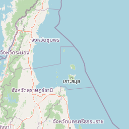
Map view of Khao Sok National Park

Use this park location map to pinpoint Khao Sok National Park in Thailand, understand its exact geographic position, and read its mapped placement within the surrounding landscape more clearly.

Pigeon | © OpenStreetMap contributors

Location context for Khao Sok National Park

Surat Thani Province
Park atlas

Trace surrounding regional geography and diverse protected landscapes connected to Khao Sok National Park's ancient rainforests.

Compare Protected Areas: National Parks and Landscapes Near Khao Sok National Park
After viewing Khao Sok National Park, explore other national parks and protected areas throughout the surrounding regional geography of southern Thailand. Compare diverse conservation landscapes, map varied terrain features, and trace how these interconnected protected areas contribute to Southeast Asia's natural heritage.
National parkPhang Nga Province

Khao Lak, Lam Ru National Park: Protected National Park Landscape and Geography

Explore its mapped boundaries and regional context in Phang Nga Province.

This entry focuses on Khao Lak, Lam Ru National Park, a designated national park offering a distinct protected landscape within Phang Nga Province, Thailand. It provides structured data and map context crucial for understanding its geographic scope and regional significance. Explore the park's mapped boundaries, its role as a protected area, and its contribution to the broader landscape of southern Thailand, fostering a deeper appreciation for its natural geography and atlas-derived insights.

Area
125 km²
Established
1991
IUCN
II
Visitors
72.2K annual
National parkSurat Thani Province

Kaeng Krung National Park: Exploring Protected Area Boundaries and Regional Geography

A National Park within Surat Thani Province's diverse landscapes.

Kaeng Krung National Park is a distinct protected area situated in Surat Thani Province, Thailand. This page provides essential context for understanding the park's geographic significance, its mapped boundaries, and its contribution to the regional protected landscape atlas. Explore the fundamental geographic characteristics that define this important natural reserve and its surrounding terrain.

Area
541 km²
Established
1991
IUCN
II
Visitors
909 annual
National parkPhang Nga Province

Khao Lampi, Hat Thai Mueang National Park: Mountain Rainforest and Andaman Coast Atlas

Explore the mapped geography and protected boundaries.

Delve into Khao Lampi, Hat Thai Mueang National Park, a key protected area within Phang Nga Province, Thailand. This unique national park showcases a striking dichotomy: the lush, waterfall-adorned slopes of the Khao Lampi mountains contrast with the pristine Andaman Sea coastline of Hat Thai Mueang beach, a critical site for sea turtle nesting. The park's mapped landscape encompasses dense tropical rainforest, significant mangrove ecosystems, and important natural terrain, offering a comprehensive view of diverse protected environments for atlas exploration.

Area
72 km²
Established
1986
IUCN
II
Visitors
50.5K annual
National parkThailand

Ao Phang Nga National Park: A Protected National Park in Thailand's Geographic Atlas

Explore the mapped landscape and protected area identity.

Ao Phang Nga National Park offers a distinct protected landscape within Thailand, serving as a key entry in the national park atlas. This page focuses on delineating its geographic boundaries and understanding its specific characteristics as a national park. Users can discover the mapped context and regional setting, providing valuable insights into Thailand's protected natural areas and their conservation significance.

Area
400 km²
Established
1981
IUCN
II
Visitors
999K annual
National parkRanong

Laem Son National Park: A Protected National Park in Ranong's Geographic Landscape

Explore the mapped natural terrain and protected area boundaries.

Laem Son National Park is a key protected area within Thailand's Ranong province, offering valuable insights into regional geography and landscape preservation. This entry focuses on its status as a national park, providing a structured view of its protected boundaries and environmental context. Understand its unique position within the mapped geography, vital for any comprehensive atlas exploration of protected lands in the region.

Area
315 km²
Established
1983
IUCN
II
Visitors
21.9K annual
National parkKrabi Province

Khao Phanom Bencha National Park: Protected Mountainous Rainforest and Waterfall Landscapes

Explore Krabi Province's unique protected area and its dramatic geographic features.

Khao Phanom Bencha National Park represents a core protected landscape within Krabi Province, Thailand. Dominated by the imposing Khao Phanom Bencha mountain range, its terrain includes steep, forested slopes and intricate valley systems that give rise to impressive waterfalls. This national park is an essential component of the region's protected natural areas, offering a detailed look at its unique ecosystem and geographic character through mapped landscape context and atlas exploration.

Area
50 km²
Established
1981
IUCN
II
Visitors
17.3K annual
National parkPhuket Province

Sirinat National Park: Phuket Province Protected Coastal Landscape and Marine Atlas

Mapped boundaries, beach forests, and sea turtle nesting sites.

Sirinat National Park offers a unique opportunity to explore a protected coastal geography on Phuket Island. This national park preserves critical beach forest ecosystems, extensive shorelines like Hat Mai Khao, vital sea turtle nesting grounds, and surrounding marine environments including coral reefs and mangrove habitats. Its designation as a protected area provides essential context for understanding the natural landscape and its ecological significance within Thailand's regional geography.

Area
90 km²
Established
1981
IUCN
II
Visitors
51.2K annual
National parkKrabi Province

Hat Noppharat Thara, Mu Ko Phi Phi National Park: Protected Landscape and Geographic Identity

Explore mapped terrain and protected natural areas in Krabi Province.

Hat Noppharat Thara, Mu Ko Phi Phi National Park stands as a distinct protected natural landscape, offering a unique geographic perspective within Krabi Province. This page delves into its role as a national park, highlighting its mapped boundaries and contribution to the regional atlas. Users can explore the park's specific natural terrain and understand its significance as a conservation area, providing a foundation for broader geographic discovery.

Area
388 km²
Established
1983
IUCN
II
Visitors
1.1M annual

Common questions about visiting, size, designation, and location context for Khao Sok National Park

Khao Sok National Park FAQs for park facts, access, geography, and protected area context
Find quick answers about Khao Sok National Park, including protected-area facts, park geography, trail and visitor context, and how the park fits into its surrounding country and regional landscape.
MoriAtlas Explorer

Continue Your Protected Areas Search Across the Global Atlas

Deepen your exploration by continuing the structured search for national parks and protected areas worldwide. Utilize the comprehensive filtering capabilities to compare different conservation landscapes and refine your understanding of global park geography. Discover more about the distribution and characteristics of protected natural areas.

Global natural geography