

Mori Atlas logo
National parkKheri Murat National Park

Discover the mapped boundaries and regional geography of this Punjab national park.

Kheri Murat National Park: Pakistan's Protected Scrub Forest Landscape on the Kala Chitta Range

Kheri Murat National Park stands as a vital protected area on the eastern edge of the Kala Chitta Range in Pakistan's Punjab region. This national park encompasses rolling scrub-forest hills characteristic of the Subtropical thorn scrub forest ecosystem, offering a unique glimpse into semi-arid wilderness. As a designated national park, it plays a crucial role in preserving regional landscapes and supporting diverse bird populations within a habitat distinct from the surrounding cultivated plains, making it a significant point of reference for geographic and conservation exploration.

National ParkScrub ForestPunjabKala Chitta RangeWildlife ConservationBirdwatching

Kheri Murat National Park

National park

Park overview

Structured park overview, official facts, and landscape profile for Kheri Murat National Park

Kheri Murat National Park park facts, protected area profile, and essential visitor context

Review the core facts for Kheri Murat National Park, including designation, size, terrain, visitor scale, habitats, and operating context in one park-focused overview.

About Kheri Murat National Park

Kheri Murat National Park protects a significant tract of scrub-forest habitat in central Punjab, an region where natural vegetation has been largely replaced by agricultural cultivation. The park occupies rolling hills on the edge of the Kala Chitta Range, a series of low mountains that rise from the surrounding plains and create a distinct ecological zone. The declaration of this area as a national park in 2020 marked an important addition to Pakistan's protected area network, particularly in Punjab Province where national parks remain relatively limited compared to other provinces.

The park is administered by the Punjab Wildlife and Parks Department, which maintains visitor facilities including marked nature trails and guided tour options. The protected area connects to Pakistan's broader environmental initiatives, notably the Protected Areas Initiative and the 10 Billion Tree Tsunami programme launched in 2020. These programmes aim to expand and improve the country's network of protected areas while addressing deforestation and habitat degradation through reforestation and conservation measures.

Quick facts and research context for Kheri Murat National Park

Kheri Murat National Park covers approximately 8,740 acres of Reserve Forest land in Attock District, Punjab, at the edge of the Kala Chitta Range. The area is classified as IUCN Category II (national park) and is managed by the Punjab Wildlife and Parks Department. The park was officially declared in 2020 as part of Pakistan's Protected Areas Initiative, with formal gazette notifications following in 2023. The landscape consists of subtropical thorn scrub forest on undulating hills, supporting Punjab urial populations and diverse avifauna.

Protection and recognition

Documented terrestrial protection scope and official environmental database records.

Kheri Murat National Park Protection Status and Conservation Designation

Researchers and conservation explorers can review the official terrestrial protection status and documented designation records for Kheri Murat National Park. Verified records compile available data on global management registries and boundary scopes to provide clear geographic context for regional planning.

Protection details

Protection scope
Terrestrial
Transboundary protection
No
Park context

Deeper park guide and search-rich context for Kheri Murat National Park

Kheri Murat National Park history, landscape, wildlife, and travel context

Explore Kheri Murat National Park through its history, landscape character, ecosystems, wildlife, conservation priorities, cultural context, and seasonal travel timing in a structured park guide built for atlas discovery and search intent.

Why Kheri Murat National Park stands out

Kheri Murat National Park is best known for its subtropical thorn scrub forest ecosystem on the Kala Chitta Range, representing a rare protected wilderness area in Punjab's intensively cultivated plains. The park provides habitat for the Punjab urial (Ovis vignei punjabiensis), a subspecies of the urial sheep that inhabits the mountainous regions of northern Pakistan. The area also serves as a bird conservation site, supporting both resident and migratory species in its scrub-forest habitat. Its proximity to the M-1 motorway and Fateh Jang makes it one of the more accessible natural areas in the Attock region.

Kheri Murat National Park history and protected-area timeline

Kheri Murat National Park was officially declared on 30 September 2020 as part of Pakistan's expanded Protected Areas Initiative. The declaration followed a period of consideration for the Kheri Murat Reserve Forest, which had already been designated as a protected forest area managed by the Attock Forest Division. A follow-up notification was issued in 2023, further solidifying the legal status of the protected area.

The park's establishment coincided with Pakistan's broader environmental policy push in 2020, which included the Green Stimulus programme and the 10 Billion Tree Tsunami reforestation initiative. These programmes aimed to address environmental challenges including deforestation, climate change, and biodiversity loss while creating economic opportunities in conservation and ecosystem restoration. The selection of Kheri Murat for national park status reflected the area's ecological value as a remaining patch of natural scrub-forest in a heavily agricultural region.

Kheri Murat National Park landscape and geographic character

The landscape of Kheri Murat National Park consists of rolling scrub-forest hills on the eastern margin of the Kala Chitta Range in Attock District. The terrain is characterized by undulating ridges and valleys covered with subtropical thorn forest vegetation. This semi-arid environment receives limited annual rainfall and experiences hot summer temperatures, creating conditions favor drought-adapted plant species.

The Kala Chitta Range itself comprises a series of low, rocky hills that rise from the Punjab plains, creating a distinctive topographical feature in an otherwise flat agricultural landscape. The forest cover within the park consists of thorn scrub vegetation typical of the Salt Range and Attock uplands, with scattered trees and dense shrub layers covering the hillsides. This terrain provides both ecological habitat and visual distinction from the surrounding cultivated plains.

Kheri Murat National Park ecosystems, habitats, and plant life

Kheri Murat National Park lies within the Subtropical thorn scrub forest biome characteristic of the Salt Range and Attock uplands of Punjab. The vegetation consists of drought-resistant species adapted to the region's semi-arid climate, including thorny shrubs and small trees that form a dense, xerophytic forest community. Survey work in the broader Kheri Murat and Khaira Murat landscape has documented vegetation assemblages including Acacia nilotica, Prosopis juliflora, Dodonaea viscosa, Adhatoda vasica, and Olea ferruginea across different elevation zones within the area.

This scrub-forest ecosystem provides important ecological functions in a region where natural vegetation has been extensively cleared for agriculture. The park serves as a biodiversity reservoir, preserving native plant species and supporting food chains that depend on the forest habitat. The protected status helps maintain ecological connectivity in an otherwise fragmented agricultural landscape.

Kheri Murat National Park wildlife and species highlights

The wildlife of Kheri Murat National Park reflects the subtropical thorn scrub forest ecosystem of the Attock uplands. The park is notable for providing habitat for the Punjab urial (Ovis vignei punjabiensis), a subspecies of the urial sheep that inhabits the mountainous and hilly regions of northern Pakistan. This wild sheep species represents an important conservation focus for the protected area.

Avifaunal surveys have documented both resident and migratory bird populations in and around the park, highlighting its significance for local bird diversity. The park's forest and shrub habitat supports various bird species throughout the year, with migratory species visiting during seasonal movements. Provincial environmental profiles also note poaching pressure on partridges in the landscape, indicating the presence of these game birds and the conservation challenges they face.

Kheri Murat National Park conservation status and protection priorities

Kheri Murat National Park contributes to Pakistan's conservation network by protecting a representative example of the subtropical thorn scrub forest ecosystem in Punjab. The park's declaration in 2020 was part of a deliberate effort to expand protected area coverage in Punjab Province, where national parks remain limited compared to other provinces. The area provides habitat for the Punjab urial, a subspecies of conservation concern, and supports significant bird populations.

Management responsibility rests with the Punjab Wildlife and Parks Department, which implements conservation measures and visitor management through the park's public pages and site resources. The protected area connects to Pakistan's national conservation programmes, including the Protected Areas Initiative and the 10 Billion Tree Tsunami programme, which aim to address habitat loss and promote ecological restoration across the country.

Kheri Murat National Park cultural meaning and human context

Kheri Murat National Park is situated in the Fateh Jang Tehsil of Attock District, an area with historical significance in the Punjab region. The park encompasses forest land previously designated as Kheri Murat Reserve Forest, reflecting a history of forest management in the area. The name Kheri Murat (also spelled Khaira Murat) appears to derive from local toponymy associated with the hill area. The park provides public access for nature recreation, offering marked trails and guided tours that allow visitors to experience the natural landscape of this edge-of-range area.

Top sights and standout views in Kheri Murat National Park

Kheri Murat National Park offers a distinctive scrub-forest wilderness experience in Punjab Province, where natural areas are otherwise rare due to extensive agriculture. The park protects the Punjab urial and provides habitat for diverse bird species, making it significant for both large mammal and avian conservation. Its location on the Kala Chitta Range creates scenic relief from the surrounding plains, while proximity to the M-1 motorway makes it accessible for day visits from Islamabad and Rawalpindi. The park's recent establishment in 2020 reflects Pakistan's ongoing efforts to expand its protected areas network and preserve remaining natural habitats.

Best time to visit Kheri Murat National Park

The best time to visit Kheri Murat National Park is during the cooler winter months from November through February, when temperatures are moderate and comfortable for outdoor exploration. Summer months (May through September) bring intense heat that can make trail hiking uncomfortable. The winter season also coincides with the period when migratory birds are present in the region, potentially enhancing birdwatching opportunities. Spring (March and April) offers pleasant weather though temperatures begin to rise, while the monsoon season (July and August) brings limited rainfall to the area.
Monthly climate preview

Examine the monthly temperature ranges and precipitation trends in the Punjab region.

Long-Term Climate Normals and Weather by Month for Kheri Murat National Park

Long-term climate data for Kheri Murat National Park show a dramatic transition from cool winters with average lows near freezing to intense summer heat peaking above forty-six Celsius. Comparing the twelve-month cycle reveals the exact timing of seasonal precipitation shifts and temperature variations throughout the Punjab landscape.
Annual mean23 °C
11 °C35 °C
Jan11°
Feb13°
Mar18°
Apr24°
May31°
Jun35°
Jul33°
Aug31°
Sep28°
Oct24°
Nov18°
Dec13°
Warmest month
June

34.8 °C

Coolest month
January

10.5 °C

Wettest month
July

5.2 mm/day

Driest month
November

0.5 mm/day

Park location guide

Geography guide, regional context, and park location map for Kheri Murat National Park

Kheri Murat National Park park geography, regions, and map view in Pakistan

Understand where Kheri Murat National Park sits in Pakistan through a broader geographic reading of the surrounding landscape, nearby location context, and its mapped position within the national park landscape.

How Kheri Murat National Park fits into Pakistan

Pakistan, officially the Islamic Republic of Pakistan, is a federal parliamentary Islamic republic in South Asia. It is the fifth-most populous country and the 33rd-largest by area. The country gained independence from British India in 1947 and has a diverse history spanning ancient civilizations including Mehrgarh and the Indus Valley Civilisation. Pakistan shares maritime borders with Oman and is bounded by the Arabian Sea, Gulf of Oman, and several neighboring countries.

Wider geography shaping Kheri Murat National Park in Pakistan

Pakistan is located in South Asia, bordered by the Arabian Sea to the south, the Gulf of Oman to the southwest, and shares land borders with India to the east, Afghanistan to the west, Iran to the southwest, and China to the northeast. The country also shares a maritime border with Oman in the Gulf of Oman. The Wakhan Corridor in Afghanistan separates Pakistan from Tajikistan in the northwest.

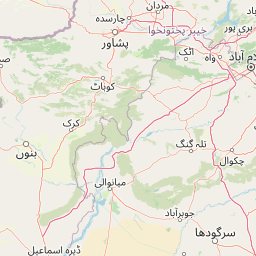
Map view of Kheri Murat National Park

Use this park location map to pinpoint Kheri Murat National Park in Pakistan, understand its exact geographic position, and read its mapped placement within the surrounding landscape more clearly.

Pigeon | © OpenStreetMap contributors

Location context for Kheri Murat National Park

Attock DistrictPunjab
Park atlas

Browse protected areas and their regional geography, comparing the scrub-forest landscapes surrounding Kheri Murat National Park.

National Parks and Protected Areas Near Kheri Murat National Park

After exploring Kheri Murat National Park, browse other national parks and protected areas within Pakistan's Punjab region. Users can compare adjacent scrub-forest landscapes, understand the regional spread of protected terrain, and identify further conservation efforts across this geography.
National parkIslamabad Capital Territory
About 31 km away#1 closest

Northeast

Margalla Hills National Park: Pakistan's Gateway to Himalayan Foothills Geography

Mapped protected landscape with rich Sino-Himalayan biodiversity.

Margalla Hills National Park, situated in the Islamabad Capital Territory, serves as Pakistan's most accessible national park and a vital entry point to the Himalayan foothills. This protected landscape is defined by its rugged mountain terrain, ranging from lower scrublands to higher pine and oak woodlands, with elevations up to 1,604 meters. The park's geological significance, with ancient marine fossil formations, adds a unique dimension to its natural identity. Discover the mapped boundaries and ecological richness that characterize this important protected area, offering insights into regional geography and diverse habitats.

Area
173.86 km²
Established
1980
IUCN
V
Relief
Mountain
National parkAttock District
About 52 km away#2 closest

Northwest

Kala Chitta National Park: Protected Dry Temperate Forest in Attock District, Pakistan

Discover unique hill landscapes and a rare ecosystem on the Pothohar Plateau.

Kala Chitta National Park represents a crucial protected area in Punjab, Pakistan, safeguarding a distinct dry temperate forest ecosystem that is uncommon in the Pothohar Plateau's heavily agricultural landscape. The park's terrain comprises rolling hills and intervening plains, contributing to its ecological richness and providing valuable mapped landscape context. Explore the geographic importance of this national park and its role in preserving a vital natural habitat.

Area
363.77 km²
Established
1983
IUCN
II
Relief
Mixed relief
National parkKhyber Pakhtunkhwa
About 54 km away#3 closest

Northeast

Ayubia National Park: Protected Area Identity and Mountainous Terrain

Discover its mapped geography within Khyber Pakhtunkhwa

Ayubia National Park stands as a key protected landscape within the Himalayan foothills of Khyber Pakhtunkhwa, Pakistan. Its designation as a national park signifies its role in conserving unique temperate coniferous and mixed forests across steep mountainous terrain. This page details the park's geographic setting, its mapped boundaries, and the natural features that define its protected status, offering a structured view for atlas-driven exploration of Pakistan's natural heritage.

Area
33.12 km²
Established
1984
IUCN
V
Visitors
250K annual
National parkPunjab
About 58 km away#4 closest

Southwest

Chinji National Park: National Park Atlas, Salt Range Geography, and Protected Landscape

Discover the unique eroded terrain and semi-arid ecosystems of Punjab, Pakistan.

Chinji National Park is a protected national park located in the Punjab province of Pakistan, specifically within the historic Salt Range. This park is characterized by its deeply eroded terrain, composed of sandstone and igneous rock formations, shaped by seasonal streams that lead towards the Soan River. As a key example of a semi-arid mountain ecosystem within the Baluchistan xeric woodlands ecoregion, Chinji National Park offers significant insights into the geological heritage and unique biodiversity of central Pakistan.

Area
60.95 km²
Established
1987
IUCN
II
Relief
Upland
National parkPunjab
About 68 km away#5 closest

Northeast

Murree-Kotli Sattian-Kahuta National Park: Punjab Protected Landscape and Watershed

Western Himalayan foothills and Pothohar Plateau geography

Located in the Rawalpindi District, this national park preserves an extensive band of rugged terrain and chir pine forests. As a critical ecological bridge between neighboring protected areas, it provides essential habitat connectivity and maintains the health of river catchments that supply water to major urban centers in Punjab.

Area
473.7 km²
Established
2020
IUCN
II
Relief
Mountain
National parkJhelum District
About 86 km away#6 closest

Southeast

Tilla Reserve National Park: Mapped Protected Landscape and Dry Forest Ecosystem

Explore the geography and ancient heritage of this Salt Range national park.

Tilla Reserve National Park is a protected area recognized for its significant dry subtropical forest ecosystems and rich cultural history within Pakistan's Salt Range. Situated in Jhelum District, the park's landscape is characterized by steep, rocky ridges and ancient geological formations. Discover its unique mapped terrain, the distribution of its remnant forest habitats, and its importance as a protected natural and spiritual site.

Area
40.6 km²
Established
2021
IUCN
II
Relief
Mountain
National parkPakistan
About 88 km away#7 closest

South

Salt Range National Park: Pakistan's Protected Landscape for Geographic Atlas Exploration

Mapped boundaries and regional terrain context for a Pakistani national park.

Gain insight into Salt Range National Park, a significant national park established within Pakistan. This entry focuses on its role as a protected landscape, providing a mapped view of its geographic scope and environmental context. Understand how this park contributes to Pakistan's broader geography and offers opportunities for atlas-based discovery of its natural terrain.

Relief
Mountain
Scope
Terrestrial
Wildlife reservePunjab
About 99 km away#8 closest

Southwest

Chumbi Surla Wildlife Sanctuary: Geographic Overview of Punjab Foothill Habitats

Mapping protected scrub forests and ridges in Khushab and Chakwal

Covering thousands of acres of contiguous reserve forest, Chumbi Surla Wildlife Sanctuary represents a crucial protected ecosystem within the Punjab landscape. This high-altitude scrub environment provides an essential refuge for the Punjab urial, characterized by deep valleys, stony slopes, and ridge systems that define the topography of the local Salt Range outliers.

Area
226.4 km²
Established
1978
IUCN
IV
Relief
Upland

Common questions about visiting, size, designation, and location context for Kheri Murat National Park

Kheri Murat National Park FAQs for park facts, access, geography, and protected area context

Find quick answers about Kheri Murat National Park, including protected-area facts, park geography, trail and visitor context, and how the park fits into its surrounding country and regional landscape.
MoriAtlas Explorer

Continue Your Protected Areas Search Across the Global Atlas

Deepen your exploration by continuing the structured search for national parks and protected areas worldwide. Utilize the comprehensive filtering capabilities to compare different conservation landscapes and refine your understanding of global park geography. Discover more about the distribution and characteristics of protected natural areas.

Global natural geography