Mori Atlas logo
National parkKibira National Park

Discover the mapped boundaries and regional landscape context of Kibira National Park.

Kibira National Park: A Protected National Park in Burundi's Geographic Landscape

Kibira National Park stands as a significant protected area within Burundi, contributing to the nation's atlas of natural landscapes. Situated in the heart of East Africa, this national park offers insights into the mapped geography and protected land distribution of the Great Rift Valley region. Understanding Kibira National Park provides a distinct view of Burundi's conservation areas and their role in the broader regional context.

Montane RainforestProtected ForestPrimate HabitatBirdwatchingCongo-Nile DivideHighland Conservation

Kibira National Park

National park

Park overview

Structured park overview, official facts, and landscape profile for Kibira National Park

Kibira National Park park facts, protected area profile, and essential visitor context
Review the core facts for Kibira National Park, including designation, size, terrain, visitor scale, habitats, and operating context in one park-focused overview.

About Kibira National Park

Kibira National Park occupies a distinctive position in Burundi's protected area network as the nation's only montane forest preserve and one of the highest-elevation protected areas in the country. The park straddles the Congo-Nile Divide, a major geological watershed that separates river systems flowing to the Congo River basin from those draining toward Lake Victoria and the Nile. This elevated terrain, reaching above 1,100 meters, supports a cool, moist microclimate that has allowed montane forest to persist where much of the surrounding highlands have been converted to agriculture or tea plantations. The park's forest cover, while reduced from its historical extent, remains ecologically significant due to its role as a refuge for species adapted to high-altitude conditions. Adjacent to large commercial tea estates at Teza and Rwegura, the park exists within a landscape shaped by both traditional land use and modern agricultural development. The montane character of Kibira distinguishes it from lower-elevation protected areas in Burundi and connects it ecologically to similar forest patches in the Rwanda highlands, particularly Nyungwe National Park to the north.

Quick facts and research context for Kibira National Park

Kibira National Park occupies 400 square kilometers across four provinces in northwestern Burundi, situated along the Congo-Nile Divide at elevations exceeding 1,100 meters. The park contains approximately 16 percent primary montane rainforest, the only such forest remaining in Burundi. It supports 644 plant species, 98 mammal species, and 200 recorded bird species, making it the country's most important site for montane-forest bird conservation. The park is contiguous with Nyungwe National Park in Rwanda and lies adjacent to two large tea plantations at Teza and Rwegura. Water from Kibira's forests supplies over three-quarters of the flow to the country's largest hydroelectric dam, which generates half of Burundi's power.

Park context

Deeper park guide and search-rich context for Kibira National Park

Kibira National Park history, landscape, wildlife, and travel context
Explore Kibira National Park through its history, landscape character, ecosystems, wildlife, conservation priorities, cultural context, and seasonal travel timing in a structured park guide built for atlas discovery and search intent.

Why Kibira National Park stands out

Kibira National Park is best known for its montane rainforest ecosystem, which represents the last remaining primary montane forest in all of Burundi. The park harbors significant populations of primates including chimpanzees and black-and-white colobus monkeys, alongside a remarkable avifauna that includes the great blue turaco, black-and-white-casqued hornbill, bar-tailed trogon, and grey parrot. The forest's montane bogs and bamboo stands create distinctive habitats within the Central African highlands, while the park's position on the Congo-Nile Divide makes it a critical watershed that supplies water to a major hydroelectric facility serving roughly half the country.

Kibira National Park history and protected-area timeline

Kibira Forest held sacred status in Burundian society long before formal protection began. Until 1933, the forest served as a hunting reserve for the kings of Burundi, with local communities maintaining traditional usage rights for livestock grazing and forest product collection. The spiritual significance attributed to the forest by surrounding communities provided informal protection that helped preserve the woodland through pre-colonial and early colonial periods. Under Belgian colonial administration, the forest was formally designated as the Congo-Nile Ridge Forest Reserve in 1933, with regulation focused primarily on controlling extraction of high-value timber. Following Burundi's independence in July 1962, the reserve status was maintained while governance transitioned to national authority. Between independence and 1980, new land allocation for cultivation within the boundary was prohibited, though traditional grazing rights were preserved. The area was redesignated as Kibira National Park in 1980, elevating its protection status to IUCN Category II. Despite this formal protection, the park faces ongoing pressures from illegal logging, bamboo harvesting, fire, poaching, and encroaching subsistence agriculture.

Kibira National Park landscape and geographic character

The landscape of Kibira National Park is defined by its position on the ridgeline of the Congo-Nile Divide, creating mountainous terrain with steep slopes and deep valleys that channel precipitation toward either the Congo or Nile drainage systems. The park occupies a high-elevation zone exceeding 1,100 meters, placing it in the montane climate band where temperature and moisture conditions differ markedly from the surrounding lower-elevation agricultural lands. The forest occurs on soils developed on ancient basement rock, with moisture retention in valley bottoms supporting areas of montane bog. Bamboo stands punctuate the forest canopy in certain areas, creating more open understory conditions. The terrain's relative inaccessibility has historically limited agricultural encroachment, though the boundaries of the park now abut productive tea plantations that mark the transition from protected forest to cultivated highlands.

Kibira National Park ecosystems, habitats, and plant life

The nature of Kibira National Park centers on its montane rainforest ecosystem, which represents the only remaining primary montane forest in Burundi. Approximately 16 percent of the park consists of old-growth forest, with the remainder having experienced varying degrees of disturbance. The canopy is dominated by species including Symphonia globulifera, Newtonia buchananii, Albizia gummifera, and Entandrophragma excelsum, creating a structurally complex forest with multiple layers. The park supports 644 documented plant species and contains distinctive habitat types including montane bogs and bamboo zones. This ecological diversity exists despite the park being less thoroughly studied than neighboring protected areas in Rwanda, where more extensive research has been conducted on similar montane forest systems.

Kibira National Park wildlife and species highlights

Kibira National Park supports 98 mammal species and 200 bird species, with particular significance attached to its primate and avifaunal communities. The park provides habitat for chimpanzees and black-and-white colobus monkeys, both of which maintain populations in the montane forest canopy. Among birds, Kibira is recognized as the most important site in Burundi for montane-forest bird conservation. Notable species include the great blue turaco, a large colorful bird distinctive to African forests, the black-and-white-casqued hornbill, bar-tailed trogon, mountain buzzard, white-spotted flufftail, and grey parrot. Many of these species are associated with intact forest interiors and serve as indicators of ecosystem health, with their presence confirming the ecological integrity of the remaining forest patches.

Kibira National Park conservation status and protection priorities

Kibira National Park holds significant conservation value as Burundi's only montane forest protected area and a critical component of the Albertine Rift biodiversity hotspot. The park's montane forest ecosystem harbors species and ecological communities found nowhere else in Burundi, making its preservation essential for maintaining national biodiversity. The watershed function of the forest, supplying the majority of water to the country's largest hydroelectric dam, adds an ecosystem service dimension to the park's conservation significance beyond wildlife habitat. However, the park faces considerable conservation challenges including illegal timber extraction, bamboo cutting, fire, poaching, and expansion of subsistence agriculture into forest edges. The park's contiguity with Nyungwe National Park in Rwanda creates a cross-border conservation opportunity, though coordinated management across the frontier remains limited.

Kibira National Park cultural meaning and human context

Kibira Forest held deep cultural significance in pre-colonial Burundian society, traditionally regarded as a sacred space invested with spiritual power by local communities. The forest was historically managed as a royal hunting reserve, with access and usage governed by traditional authorities. Local people maintained recognized rights to graze livestock and gather forest products, creating a system of customary management that balanced human use with forest preservation. This cultural relationship with the forest predates colonial intervention and contributed to the woodland's survival through centuries of traditional land use. The sacred character of the forest, though diminished under modern governance, represents a cultural heritage dimension that shaped the landscape's ecological continuity.

Top sights and standout views in Kibira National Park

Kibira National Park offers visitors the opportunity to experience Burundi's only montane rainforest, with guided trails through forest habitat where chimpanzees and black-and-white colobus monkeys can be observed. The park's avifauna, including the spectacular great blue turaco and distinctive black-and-white-casqued hornbill, draws birdwatchers to this high-elevation forest. The park's position on the Congo-Nile Divide provides scenic highland views, while the montane bogs and bamboo stands create varied habitat for exploration. The ecological continuity with Nyungwe National Park in Rwanda offers potential for transboundary conservation experiences. The watershed services provided by Kibira's forests, generating half of Burundi's hydroelectric power, underscore the park's national importance beyond recreational value.

Best time to visit Kibira National Park

The best time to visit Kibira National Park corresponds to the dry seasons, typically from June to August and December to February, when trail conditions are more favorable and wildlife viewing is facilitated by reduced vegetation density. The montane environment experiences year-round relatively mild temperatures due to the elevation, though rainfall is concentrated in the wet seasons when trails may become more difficult to navigate. Visitors should be prepared for cool conditions at these high elevations and should check current access conditions, as the park's infrastructure and access can change based on local management and security considerations.

Park location guide

Geography guide, regional context, and park location map for Kibira National Park

Kibira National Park park geography, regions, and map view in Burundi
Understand where Kibira National Park sits in Burundi through a broader geographic reading of the surrounding landscape, nearby location context, and its mapped position within the national park landscape.

How Kibira National Park fits into Burundi

Burundi is a landlocked East African country with a population of over 14 million people. Located in the Great Rift Valley, it borders Rwanda to the north, Tanzania to the east and southeast, and the Democratic Republic of the Congo to the west. Lake Tanganyika lies along its southwestern border. The capital is Gitega and the largest city is Bujumbura.

Wider geography shaping Kibira National Park in Burundi

Burundi is located in East Africa in the Great Rift Valley region, at the junction between the African Great Lakes area and Southeast Africa. It is landlocked and borders Rwanda to the north, Tanzania to the east and southeast, and the Democratic Republic of the Congo to the west. Lake Tanganyika lies along its southwestern border, providing access to major waterways.

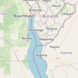
Map view of Kibira National Park

Use this park location map to pinpoint Kibira National Park in Burundi, understand its exact geographic position, and read its mapped placement within the surrounding landscape more clearly.

Pigeon | © OpenStreetMap contributors
Park atlas

Map the interconnected protected areas and diverse montane ecosystems across Burundi's highlands and the Great Lakes region.

Discover Other Protected Areas Around Kibira National Park and the Congo-Nile Divide
Browse a curated atlas of national parks and protected areas near Kibira National Park, including the unique montane rainforests of Burundi and the broader Congo-Nile Divide region. Explore these adjacent conservation landscapes to trace shared ecosystems, compare diverse protected habitats, and understand their regional geographic context.
National parkBurundi

Rusizi National Park: National Park in Burundi's Geographic Landscape Context

Explore mapped protected area boundaries and regional geography.

Rusizi National Park stands as a significant protected area within Burundi, contributing to the nation's conservation atlas. This national park offers a distinct geographic profile, showcasing its specific landscape and terrain features within the East African context. Users can delve into the mapped boundaries of Rusizi National Park to understand its protected status and its role in the regional geography, facilitating detailed geographic discovery.

Area
90 km²
Established
1980
IUCN
II
Climate
Tropical
National parkSouth Kivu Province

Kahuzi-Biéga National Park: A Protected Landscape in South Kivu Province's Albertine Rift

Explore its mapped boundaries and diverse terrain.

Kahuzi-Biéga National Park, a significant national park in South Kivu Province, is defined by its dramatic geographic diversity. Spanning approximately 6,000 square kilometers, it features a unique ecological gradient from dense lowland equatorial rainforest in the west to the subalpine zones of the Mitumba Mountains in the east, dominated by the dormant volcanoes Mount Kahuzi and Mount Biéga. This protected landscape offers a rich atlas context for understanding the biodiversity and regional geography of the Albertine Rift, showcasing a vital transition in terrain and habitat.

Area
6,000 km²
Established
1970
IUCN
II
Relief
Mixed relief
National parkBurundi

Ruvubu National Park: A National Park in Burundi Focused on Protected Landscape Geography

Explore the mapped boundaries and regional context of Ruvubu.

Investigate Ruvubu National Park, a protected natural area in Burundi, and understand its geographic significance. This page serves as a detailed atlas entry, highlighting the park's mapped extent and its contribution to the regional landscape of East Africa. Explore the protected-area context and geographical features that define Ruvubu National Park for discovery and analysis.

Area
508 km²
Established
1980
IUCN
II
Relief
Mixed relief
National parkWestern Province

Gishwati Forest National Park: Discover Rwanda's Protected Landscape Geography

Mapped protected area boundaries and regional natural landscape.

Gishwati Forest National Park offers a focused exploration of a significant protected natural landscape in Rwanda's Western Province. This resource provides detailed geographic context, highlighting the park's mapped boundaries and its role within the country's conservation areas. Understand its terrain and regional landscape importance through an atlas-centric view.

Area
32.02 km²
Established
2015
IUCN
IV
Relief
Mountain
National parkRwanda

Volcanoes National Park: Rwanda's Protected Volcanic Landscape and Regional Geography

Mapped park boundaries and East African geographic context.

Delve into Volcanoes National Park, a crucial protected area within Rwanda's northwest. This page offers detailed insight into its geography, highlighting the volcanic terrain and mapped boundaries that define this important national park. Understand its placement within the Virunga Mountains and its contribution to the natural landscape of East Africa, providing a foundation for atlas-based exploration of protected lands.

Area
160 km²
Established
1925
IUCN
II
Relief
Mountain
National parkTanzania

Burigi-Chato National Park: Protected Landscape Atlas Entry for Tanzania

Explore the mapped geography and terrain of this Tanzanian national park.

Burigi-Chato National Park serves as a distinct protected area within Tanzania, detailed here for its geographic significance and atlas exploration value. Users can delve into the park's specific landscape characteristics, its protected boundaries, and its regional setting. This content is designed to support a deeper understanding of conservation lands and natural terrain within the East African context, offering a factual entry point for detailed geographic discovery.

Area
4,707 km²
Established
2019
IUCN
II
Relief
Mixed relief
National parkEastern Province

Akagera National Park National Park: Protected Landscape Geography and Atlas Exploration

Understand the mapped terrain and regional context of Akagera National Park.

Akagera National Park, designated as a national park, represents a vital protected landscape within Rwanda's Eastern Province. This atlas-focused entry provides essential geographic context, highlighting the park's mapped boundaries and natural terrain. Explore Akagera National Park as a key element in regional geography and a focal point for understanding protected land distribution.

Area
1,122 km²
Established
1934
Visitors
34K annual
Relief
Mixed relief
Watercolor illustration of rolling hills, mountains, and a river or lake
National parkDemocratic Republic of the Congo

Virunga National Park: Democratic Republic of the Congo's Premier Protected Landscape

Mapped boundaries and diverse Albertine Rift endemic geography.

Virunga National Park represents a pivotal protected area within the Democratic Republic of the Congo, characterized by an exceptional range of geographic features and vital ecosystems. Its protected landscape includes active volcanoes like Nyiragongo with its lava lake, the towering Rwenzori Mountains, and diverse lowland savannas. This atlas-focused entry highlights the park's unique position in the Albertine Rift, crucial for numerous endemic species and offering significant insight into regional geography and protected land context.

Area
7,800 km²
Established
1925
IUCN
II
Relief
Mountain

Common questions about visiting, size, designation, and location context for Kibira National Park

Kibira National Park FAQs for park facts, access, geography, and protected area context
Find quick answers about Kibira National Park, including protected-area facts, park geography, trail and visitor context, and how the park fits into its surrounding country and regional landscape.
MoriAtlas Explorer

Continue Your Protected Areas Search Across the Global Atlas

Deepen your exploration by continuing the structured search for national parks and protected areas worldwide. Utilize the comprehensive filtering capabilities to compare different conservation landscapes and refine your understanding of global park geography. Discover more about the distribution and characteristics of protected natural areas.

Global natural geography