
Streams
Park geography
Detailed landscape analysis, elevation metrics, and terrain distribution in Central Chile
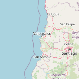
Geographic Profile and Mapped Boundaries of La Campana National Park in the Valparaiso Region
This geographic record provides a comprehensive overview of the land area and environmental features defining La Campana National Park. Users can analyze the park extent covering 80 square kilometers, observe elevation shifts ranging from 600 meters to 2222 meters, and examine the diverse mountain terrain within the Valparaiso Region.
Chile's coastal mountain sanctuary of the southernmost palm and Darwin's historic summit
La Campana National Park
La Campana National Park is a protected area in central Chile located in the Cordillera de la Costa, Quillota Province, within the Valparaíso Region. The park encompasses approximately 80 square kilometers of Mediterranean ecosystems and is renowned for containing one of the last remaining natural forests of the Chilean Wine Palm (Jubaea chilensis), a species that once dominated much of central Chile but now survives in only a few locations. The park takes its name from Cerro La Campana, an 1,828-meter mountain whose distinctive shape resembles a bell when viewed from the Aconcagua Valley. In 1834, the renowned naturalist Charles Darwin climbed this peak during the second voyage of HMS Beagle, adding significant scientific heritage to the area. In 1984, UNESCO designated La Campana, together with the Lago Peñuelas National Reserve, as a Biosphere Reserve recognizing its exceptional biodiversity value. The park sits within the Chilean matorral ecoregion and protects a remarkable concentration of plant species, with roughly 20 percent of Chile's total flora represented within its boundaries.
- Location
- Chile
- Park type
- National park
- Established
- 1967
- Area
- 80 km²
- Highest point
- 1,828 m
Location overview
National and regional placement within the Valparaíso Region
Mapping the Geography of La Campana National Park in Chile
La Campana National Park is situated in Chile, within the Quillota Province of the Valparaíso Region. The inland park lies entirely within national borders, featuring no coastal, marine, or transboundary territory.
- Countries
- Chile
- Regions
- Quillota Province, Valparaíso Region
- Primary location
- Valparaíso Region
- Geographic setting
- Inland
Boundary and coordinates
Mapped perimeter geometry and derived area metrics for spatial context
La Campana National Park Boundary Map and Geographic Extent
Interactive boundary geometry outlines the spatial footprint of the protected area for detailed geographic study. Recorded spatial metrics provide numerical context regarding total surface area, coordinate limits, and geographic span.
- Boundary area
- 79.1 km²
- Boundary perimeter
- 44.7 km
- Northernmost point
- 32.9147° S
- Southernmost point
- 33.018° S
- Easternmost point
- 71.0104° W
- Westernmost point
- 71.1561° W
- Geographic centre
- 32.966° S, 71.0831° W
- North–south span
- 11.5 km
- East–west span
- 13.6 km
Elevation and terrain
Mountain relief metrics and recorded natural features
La Campana National Park Terrain and Elevation Range
Recorded elevation records outline the mountain terrain summary and vertical range within La Campana National Park. Individual feature cards list the names, types, and spatial relationships of streams, peaks, and waterfalls.
- Minimum elevation
- 600 m
- Maximum elevation
- 2,222 m
- Highest point
- 1,828 m
Selected named natural features
Streams
Quebrada El Arenal
Streams
Quebrada Larga
Streams
Quebrada Agua del Manzano
Waterfalls
Salto La Cortadera
Peaks
Cerro Los Penitentes
1,361 m
Environmental setting
Stored Mediterranean climate zones, mountain relief, and forest cover profiles
La Campana National Park Environmental Setting and Physical Classifications
Recorded landscape features, habitat types, and relief attributes function as interpretive categories for understanding the physical setting of La Campana National Park. Stored classifications connect directly to broader regional atlas destinations and related protected area records.
- Relief
- Mountain
- Climate
- Mediterranean
- Water
- Minor water
- Forest cover
- Mostly forested
- Seasonality
- Year-round
Landscape features
Mountains · Valleys · Forest · Woodland · Grassland · Cliffs
Habitat types
Mediterranean forest · Temperate broadleaf forest · Shrubland · Grassland
Park atlas
Trace the protected landscapes and park geography surrounding La Campana National Park in central Chile's coastal ranges.
Compare Nearby National Parks and Protected Areas Around La Campana National Park
Browse a focused list of national parks and other protected areas situated near La Campana National Park, encompassing distinct Mediterranean and coastal mountain landscapes. Explore these protected areas to compare their distinct features, understand regional conservation strategies, and trace their geographic spread across Chile's central coastal range.
National parkSantiago Metropolitan Region
94 km away#1 closest
Southeast

Río Clarillo National Park: National Park Boundaries and Geographic Atlas Context
Mapped protected landscape in Santiago Metropolitan Region.
Discover the distinct protected landscape of Río Clarillo National Park, a national park situated within Chile's Santiago Metropolitan Region. This entry is designed for atlas-style exploration, focusing on the park's mapped boundaries, its integration into the regional geography, and its significance as a protected natural area. Understand the geographic context and landscape characteristics that define Río Clarillo National Park, enabling a deeper appreciation of its role within the broader conservation map.
- Area
- 101.85 km²
- Established
- 1982
- IUCN
- IV
- Relief
- Upland
National parkLibertador General Bernardo O'Higgins Region
127 km away#2 closest
South
Las Palmas de Cocalán National Park: Chile's National Park Protected Landscape Atlas
Explore geographic boundaries and regional context.
Delve into the protected landscape identity of Las Palmas de Cocalán National Park, situated within the Libertador General Bernardo O'Higgins Region. This page provides detailed atlas-style information, focusing on the park's geographic features and its role as a national park. Understand the mapped natural terrain and the regional importance of this conserved area for comprehensive geographic discovery.
- Area
- 3.709 km²
- Established
- 1971
- IUCN
- II
- Relief
- Mixed relief
National parkArgentina
180 km away#3 closest
Northeast

El Leoncito National Park: High-Altitude Andean Puna and Steppe Protected Landscape
Explore mapped boundaries and unique geographic context in San Juan Province.
El Leoncito National Park in Argentina's San Juan Province preserves critical high-altitude ecosystems, including the Central Andean Puna and Southern Andean steppe. This protected landscape spans dramatic mountain terrain, with elevations reaching over 6,000 meters, providing a unique geographic setting. The park's conservation value is underscored by its representative ecological samples and stark natural beauty, offering a distinct regional geography for exploration.
- Area
- 897.06 km²
- Established
- 2002
- IUCN
- II
- Relief
- Mountain
National parkCoquimbo Region
234 km away#4 closest
North
Bosque de Fray Jorge National Park: National Park Protected Landscape & Geographic Atlas
Explore mapped boundaries and regional natural landscape context.
Bosque de Fray Jorge National Park is a key protected area offering unique insights into Chile's natural landscapes. This entry provides detailed geographic context, focusing on its status as a national park and its mapped boundaries within the Coquimbo Region. Discover its place in the regional atlas and understand its protected landscape identity for focused geographic exploration.
- Area
- 100 km²
- Established
- 1941
- IUCN
- II
- Visitors
- 13.1K annual
National parkMaule Region
266 km away#5 closest
South
Radal Siete Tazas National Park: Iconic Seven Cups Waterfall System and Pre-Andean Terrain Exploration
Mapped protected landscape in Maule Region, Chile.
Radal Siete Tazas National Park showcases a remarkable cascade of seven natural rock pools and waterfalls along the Claro River, a defining feature within its steep pre-Andean topography. This national park in Chile's Maule Region offers a landscape rich with volcanic influences and dramatic riverine erosion. Users can explore its distinct terrain, mapped boundaries, and the striking visual geography that makes this protected area a significant natural landmark for atlas-based discovery.
- Area
- 41.4 km²
- Established
- 2008
- IUCN
- II
- Relief
- Mountain
National parkArgentina
351 km away#6 closest
East
Sierra de las Quijadas National Park: Protected Landscape & Geographic Atlas in Argentina
Explore the unique Chaco-Monte ecotone and dramatic sandstone terrain.
Sierra de las Quijadas National Park in San Luis Province, Argentina, is a protected area recognized for its critical role as a biodiversity bridge between the Semiarid Chaco and High Monte ecoregions. Its landscape is marked by rugged mountains, vivid red sandstone cliffs, and significant paleontological sites, offering a unique look at Cretaceous-era geology. This park provides a rich opportunity for atlas exploration, allowing discovery of its distinctive protected landscape and the regional geography it inhabits.
- Area
- 735.33 km²
- Established
- 1991
- IUCN
- II
- Relief
- Mountain
National parkArgentina
414 km away#7 closest
Northeast
San Guillermo National Park: High Andes Protected Landscape & Vicuña Conservation Area
Explore its rugged terrain and arid mountain ecosystem.
San Guillermo National Park, a key national park in Argentina's San Juan Province, protects over 166,000 hectares of high-altitude Andean wilderness. Its landscape is defined by arid mountain ranges and expansive puna grasslands, serving as a critical sanctuary for vicuñas and other high-Andean wildlife. This page offers detailed geographic context for understanding the park's protected boundaries, unique terrain, and its importance as a mapped conservation area.
- Area
- 1,660 km²
- Established
- 1998
- IUCN
- II
- Relief
- Mountain
State or regional parkSan Juan Province
About 430 km away#8 closest
Northeast
Ischigualasto Provincial Park: A Detailed Atlas of Argentina's Triassic Fossil Landscapes
Geological mapping of wind-eroded badlands in San Juan Province
Ischigualasto Provincial Park is a globally significant protected area that offers a rare view into the Late Triassic period. Known as the Valley of the Moon, its arid desert basin and exposed rock sequences document the emergence of the first dinosaurs. This destination provides an intensive look at how extreme aridity and constant winds have sculpted a distinctive, colorful badlands landscape in the foothills of the Central Sierras.
- Area
- 603.7 km²
- Established
- 1971
- Relief
- Upland
- Climate
- Arid
MoriAtlas Explorer
Continue Exploring La Campana National Park's Geographic Significance
Delve deeper into the unique protected landscape of La Campana National Park, understanding its specific mapped boundaries and role within the Valparaíso Region's geography. This exploration uncovers critical details about its relict palm forests and mountainous terrain, offering valuable insight for any atlas-focused study of Chile's natural areas.
Browse next
Global natural geography
Explore related park routes
Explore MoriAtlas Global ParksBrowse All MoriAtlas ParksGlobal Park Map DiscoveryMoriAtlas: Browse All CountriesBrowse All MoriAtlas ContinentsNational Park Environment AtlasGrand Canyon National Park AtlasYellowstone National Park AtlasYosemite National Park Atlas and GeographySerengeti National Park AtlasGalápagos National Park Protected LandscapeBanff National Park Geography and AtlasKruger National Park Atlas EntryUluṟu-Kata Tjuṯa National Park AtlasExplore Uluru-Kata Tjuta National Park GeographyPlitvice Lakes National Park AtlasFiordland National Park Protected LandscapeGreat Smoky Mountains National Park AtlasAfghanistan National Parks and Protected AreasAlbania National Parks and Protected AreasAlgeria National Parks and Protected AreasAmerican Samoa National Parks and Protected AreasAndorra National Parks and Protected AreasAngola National Parks and Protected AreasAntarctica National Parks and Protected AreasAntigua and Barbuda Park List