Why Laguna de Términos stands out
Laguna de Términos is best known for its expansive mangrove forests, which dominate the lagoon's margins and form one of the most extensive mangrove systems on Mexico's Gulf coast. These mangroves play a critical ecological role, anchoring sediments, filtering freshwater, and acting as a natural defense against storm surges and hurricane impacts. The lagoon is also recognized for its exceptional biological richness, with more than 2,200 recorded species of plants and animals, and for its position alongside the Pantanos de Centla Biosphere Reserve as part of Mexico's largest hydrological basin. Its proximity to offshore oil installations and the historic port of Ciudad del Carmen also makes it a notable convergence of industrial activity and tropical coastal ecology.
Laguna de Términos history and protected-area timeline
Laguna de Términos takes its name from the 1518 expedition of Juan de Grijalva, the first European to reach Isla del Carmen. Mistaking Yucatán for an island, the Spanish named the lagoon as a kind of geographic terminus, the body of water they believed bordered the supposed island of Yucatán on its inner side.
For centuries afterward, the lagoon functioned primarily as a productive coastal fishery, with shrimp, oysters, snook, and other species anchoring the local economy of towns like Ciudad del Carmen on the adjacent island. Its strategic location near the Gulf of Campeche also gave it growing economic importance in the twentieth century as Mexico developed offshore oil production in the surrounding waters.
Formal environmental recognition came later than its long history of human use. On June 6, 1994, the Mexican government designated the area as an Área de Protección de Flora y Fauna, establishing a protected zone of more than 705,000 hectares around the lagoon and its surrounding wetlands. On February 2, 2004, the area received international recognition through its inscription as Ramsar Site number 1356, acknowledging it as a wetland of global importance within the larger Laguna de Términos basin.
Laguna de Términos landscape and geographic character
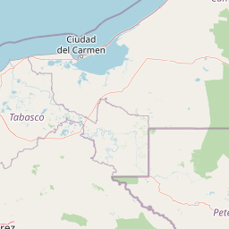
The physical setting of Laguna de Términos is shaped by a wide, shallow coastal lagoon flanked by a deltaic plain of mangroves, marshes, and tropical forest. The lagoon's surface extends roughly 2,007 square kilometers, with maximum depths reaching only about 4 meters, making it a flat, open body of water rather than a deep basin. Its shoreline is irregular, defined by river mouths, tidal channels, and the long barrier of Isla del Carmen along its eastern side.
Surrounding the lagoon is a mosaic of coastal environments: dense mangrove swamps at the water's edge, freshwater marshes inland, and patches of tropical lowland forest on higher ground. Río Palizada, Río Chumpán, and Río Candelaria all reach the lagoon through branching distributaries, depositing sediments that feed the surrounding wetlands and gradually reshape the shoreline. The result is a soft, water-dominated landscape where land and sea intergrade over many kilometers.
Climate and exposure play a major role in shaping the lagoon. Positioned on the Gulf of Mexico, the area is regularly influenced by tropical storms and hurricanes, making the buffering effect of the mangrove fringe especially important to the lagoon and the communities around it. The combination of flat coastal topography, heavy seasonal rainfall, and river input creates a dynamic landscape that is both ecologically productive and physically vulnerable.
Laguna de Términos ecosystems, habitats, and plant life
Laguna de Términos lies within a major tropical wetland ecosystem that combines marine, brackish, and freshwater habitats. The lagoon's shallow, nutrient-rich waters and protected shoreline support extensive mangrove forests dominated by species typical of Mexico's Gulf coast, along with seagrass beds, tidal flats, and submerged aquatic vegetation. These habitats form an interconnected mosaic that sustains one of the most ecologically productive coastal systems in southeastern Mexico.
Beyond the mangroves, the lagoon's margins include freshwater marshes and flooded forests linked to the inflowing river systems. The adjoining Pantanos de Centla Biosphere Reserve extends this wetland habitat westward, creating a continuous corridor of marsh and swamp that filters water flowing into the lagoon from the interior. Smaller satellite lagoons such as Pom, Atasta, San Carlos, and Balchacah extend the diversity of habitats still further.
According to Mexico's National Biodiversity Information System, the broader protected area is home to more than 2,240 species of plants and animals, including a substantial number listed under risk categories in the Mexican official standard NOM-059, as well as numerous introduced species. This diversity reflects the lagoon's role as an interface between marine and freshwater environments, and as a transition zone between the Yucatán Peninsula and the Gulf of Mexico.
Laguna de Términos wildlife and species highlights
The lagoon's wildlife profile is shaped by its position at the boundary of marine, brackish, and freshwater environments. Its mangrove forests serve as nursery habitat for commercially important fish and crustaceans, including species such as shrimp, snook, mojarra, and shark that are also central to local fisheries. Sea turtles are present in the lagoon, and oyster beds contribute to both the ecology and the regional economy.
Dolphins are a regular and well-documented presence in Laguna de Términos, frequently observed in its waters and recognized as one of the lagoon's characteristic marine mammals. The surrounding mangrove and marsh habitats support a wide variety of birds, reptiles, and amphibians that rely on the dense cover and rich food supply. Reptiles in particular find the mangrove fringe favorable for nesting and shelter.
The combination of mangrove nurseries, riverine inputs, and connections to the open Gulf of Mexico makes the lagoon a key feeding and breeding area for both resident and migratory species. While the area has also seen the introduction of exotic species, its overall biological richness remains a defining feature, with more than two thousand recorded species across the protected area's plants and animals.
Laguna de Términos conservation status and protection priorities
Laguna de Términos holds substantial conservation significance as one of Mexico's largest protected wetlands. Designated a flora and fauna protection area in 1994, it safeguards more than 705,000 hectares of mangrove, marsh, lagoon, and tropical forest in a single contiguous framework. The 2004 Ramsar designation further recognized the lagoon's importance at the international level, placing it in a global network of wetlands considered critical for waterbird habitat, biodiversity, and ecological function.
From a conservation standpoint, the lagoon's mangroves are its most important feature. They stabilize sediments, filter freshwater from the inflowing rivers, and act as a natural barrier against storm surges and hurricanes, a function of particular relevance in a region regularly exposed to tropical cyclones. Their role as nursery habitat for commercially important fish and crustaceans also links the conservation of the mangrove system directly to the long-term viability of regional fisheries.
The protected area also plays a hydrological role within Mexico's largest drainage basin, working in concert with the neighboring Pantanos de Centla Biosphere Reserve to regulate water flow, sediment, and water quality across a vast wetland landscape. While the area faces pressures from offshore petroleum activity in adjacent waters and from regional fisheries, the overlapping national and international designations provide a formal framework for its protection.
Laguna de Términos cultural meaning and human context
Laguna de Términos has been woven into regional identity and economy for centuries. Isla del Carmen, the long barrier island that defines the lagoon's eastern edge, hosts the city of Ciudad del Carmen, a settlement whose origins stretch back to colonial times and whose modern character has been shaped by fishing, trade, and offshore petroleum. The lagoon itself has long supported fishing communities whose livelihoods revolve around shrimp, oyster, snook, and other species harvested from its waters.
The historical misunderstanding that gave the lagoon its name, the 1518 Spanish belief, under Juan de Grijalva, that Yucatán was an island, remains a defining moment in the cultural memory of the area. It marks the lagoon as a place where European exploration, cartographic confusion, and the long human presence of coastal Campeche all converge.
In the modern era, the lagoon sits at the intersection of traditional fisheries, oil and gas development in the Campeche Sound, and a growing framework of environmental protection. The coexistence of these activities has become a central part of the cultural and economic context of the region.
Top sights and standout views in Laguna de Términos
Straddling the coast of Campeche and the Gulf of Mexico, Laguna de Términos is one of the largest and most ecologically rich coastal lagoons in Mexico. Its defining features include an exceptionally broad mangrove fringe, a deep connection with Mexico's largest hydrological basin, and direct adjacency to the Pantanos de Centla Biosphere Reserve, together forming a continuous corridor of tropical wetland.
Its protection profile is unusually strong: designated as a flora and fauna protection area in 1994 and recognized globally through its 2004 Ramsar listing. The lagoon's combination of mangrove nurseries, productive fisheries, dolphin populations, and storm-buffering ecosystem services makes it a high-value site for both biodiversity conservation and regional resilience against tropical storms.
Best time to visit Laguna de Términos
The lagoon experiences the climate patterns typical of the southern Gulf of Mexico, with a dry season and a wet season that strongly influence the rhythm of the landscape. The dry months, generally from late winter through spring, tend to offer calmer seas, lower rainfall, and easier conditions for boat-based exploration of the lagoon and its mangrove channels. Wildlife observation is often productive during this period, when water levels are more stable and bird activity remains high.
The wet and hurricane season, roughly from summer into early autumn, brings heavier rains and greater risk of tropical storms and hurricanes. While this is when the wetlands are most lush and biologically active, it is also when storm-related disruption is most likely. Many visitors favor the transitional shoulders between seasons for a balance of comfortable weather and active ecosystems, though conditions can vary. As in any tropical coastal region, awareness of local weather and hurricane alerts is essential when planning a visit.