
Rivers
Park geography
Analyzing the regional geography, mountainous terrain, and coastal landscape distribution
Comprehensive Geographic Profile and Mapped Boundaries of Laguna San Rafael National Park
This geographic profile details the physical scope of Laguna San Rafael National Park within the Aysén del General Carlos Ibáñez del Campo Region of Chile. Explore the recorded boundary coverage of 17,420 square kilometers alongside the park mountain range, major peaks including Monte San Valentín, and the complex coastal and subpolar environmental features.
Related tags
Glacial landscapesUNESCO Biosphere ReservePatagoniaTidewater glaciersNorthern Patagonian Ice Field
Patagonian wilderness of glaciers, fjords, and ice fields in southern Chile
Laguna San Rafael National Park
Laguna San Rafael National Park is a vast protected area spanning over 17,000 square kilometers along the Pacific coast of southern Chile in the Aysén Region. The park is named for San Rafael Lagoon, a striking glacial lake formed by the retreat of the San Rafael Glacier, and encompasses portions of the Northern Patagonian Ice Field, one of the largest temperate ice bodies in the Southern Hemisphere. The landscape is characterized by dramatic mountain peaks including Monte San Valentín, deep fjords, and a network of rivers that drain into the Gulf of Penas and Moraleda Channel. Established in 1959 and designated a UNESCO Biosphere Reserve in 1979, the park protects a remarkable transition zone between the Andes and the Pacific coast, where heavy precipitation feeds both glacial systems and temperate rainforest ecosystems. The area holds exceptional significance for conservation, protecting critical habitat for marine mammals including endangered southern right whales and providing sanctuary for diverse bird and terrestrial species.
- Location
- Chile
- Park type
- National park
- Established
- 1959
- Area
- 17,420 km²
Location overview
Coastal and marine status within the Aysén Region of Chile
Geographic Positioning of Laguna San Rafael National Park in Chile
Laguna San Rafael National Park is situated in Chile, within the Aysén del General Carlos Ibáñez del Campo Region. It holds distinct coastal and marine classifications under a single national jurisdiction.
- Countries
- Chile
- Regions
- Aysén del General Carlos Ibáñez del Campo Region
- Primary location
- Aysén del General Carlos Ibáñez del Campo Region
- Geographic setting
- Coastal · Marine
Boundary and coordinates
Interactive boundary geometry and derived geographic measurements
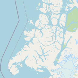
Laguna San Rafael National Park Boundary Map and Spatial Extent
Mapped park outlines provide precise spatial context for exploring territorial limits and regional boundaries. Accompanying boundary facts detail total calculated area spans and coordinate extents without claiming legal survey precision.
- Boundary area
- 22,017.9 km²
- Boundary perimeter
- 1,209.1 km
- Northernmost point
- 46.1976° S
- Southernmost point
- 47.7507° S
- Easternmost point
- 72.6776° W
- Westernmost point
- 75.6958° W
- Geographic centre
- 46.9077° S, 74.094° W
- North–south span
- 172.7 km
- East–west span
- 229.6 km
Terrain and natural features
Mountain terrain structure and recorded natural features within the park
Laguna San Rafael National Park Terrain Classifications and Named Features
Mountain terrain classifications define the physical geography of Laguna San Rafael National Park alongside recorded peaks, rivers, bays, and lakes. Linked feature cards supply names, types, measurements, and spatial relationships for each recorded natural feature.
Selected named natural features
Bays
Estero Benito
Bays
Caleta Cliff
Peaks
Monte Triangular
859 m
Peaks
Cerro Esmeralda
172 m
Peaks
Cerro Pared Sur
2,548 m
Environmental setting
Subpolar mountain relief, dominant water features, and seasonal glacier terrain
Laguna San Rafael National Park Environmental Classification and Physical Setting
Recorded landscape features, climate zones, and relief types combine to frame the physical setting of Laguna San Rafael National Park. Mapped classification categories connect directly to related protected areas and regional atlas destinations.
- Relief
- Mountain
- Climate
- Subpolar
- Water
- Water-dominated
- Seasonality
- Strongly seasonal
Landscape features
Mountains · Lakes · Rivers · Coast · Glacier
Park atlas
Compare surrounding Patagonian protected areas, tracing connected glacial systems and fjord geography.
Discover National Parks and Protected Areas Near Laguna San Rafael in Chile's Patagonian Fjords
After exploring Laguna San Rafael National Park, continue your journey through nearby national parks and protected areas that share Chile's dramatic Patagonian fjords and glacial terrain. Compare diverse conservation landscapes, tracing the regional spread of ice fields, coastal ecosystems, and mountain ranges for comprehensive geographic insight.
National parkAysén Region
7.2 km away#1 closest
Southeast

Patagonia National Park, Chile: Exploring Protected Landscape and Regional Geography
Mapped boundaries and natural terrain in Aysén Region.
Patagonia National Park, situated within the Aysén Region of Chile, serves as a significant protected area offering rich opportunities for atlas-based geographic exploration. This national park's specific landscape identity and mapped boundaries provide a clear focal point for understanding regional conservation and natural terrain. Discover the geographic context of this protected land and its place within the broader landscape of southern Chile through structured data and map exploration.
- Area
- 3,045.28 km²
- Established
- 2018
- IUCN
- II
- Relief
- Mountain
National parkAysén del General Carlos Ibáñez del Campo Region
30 km away#2 closest
South
Bernardo O'Higgins National Park: Southern Patagonian Ice Field & Glacial Terrain
Chile's largest protected area: a map of vast ice caps and fjords.
Bernardo O'Higgins National Park is a colossal protected landscape in Chile, safeguarding much of the Southern Patagonian Ice Field and its colossal glacial features like the Pío XI Glacier. Explore the dramatic terrain of towering granite peaks and intricate fjord systems that define this remote national park. This page provides essential context for understanding its geography, mapped boundaries, and significance as a vast wilderness preservation.
- Area
- 35,259 km²
- Established
- 1969
- IUCN
- II
- Visitors
- 36K annual
National parkArgentina
44 km away#3 closest
Southeast

Perito Moreno National Park: Argentina's Expansive Patagonian Protected Landscape
Explore its mapped terrain and significant protected area geography.
Perito Moreno National Park stands as a cornerstone of Argentinian conservation, safeguarding over 126,000 hectares of striking Patagonian mountain wilderness. This national park protects a rare ecological transition zone, blending wet Andean forests with dry steppe environments across its dramatic amphitheater-like terrain and dual-watershed hydrography. Its mapped boundaries encompass significant natural geography, offering a clear atlas view of protected Patagonian landscapes.
- Area
- 1,268.3 km²
- Established
- 1937
- IUCN
- II
- Relief
- Mountain
National parkAysén del General Carlos Ibáñez del Campo Region
62 km away#4 closest
Northeast
Cerro Castillo National Park: Dramatic Granite Peaks and Patagonian Protected Landscape
Mapped geography and huemul conservation in Chile's Aysén Region.
Cerro Castillo National Park is a premier protected area in southern Chile, celebrated for its iconic Cerro Castillo granite mountain that dominates the landscape. This national park, spanning over 1,700 square kilometers in the Aysén del General Carlos Ibáñez del Campo Region, showcases a dynamic Patagonian terrain shaped by glaciers and rivers. Its significance extends to being a vital corridor for endangered huemul, offering critical habitat within a broader regional conservation strategy and the famous Route of Parks.
- Area
- 1,795.5 km²
- Established
- 1970
- IUCN
- II
- Relief
- Mountain
National parkArgentina
About 113 km away#5 closest
East
Patagonia National Park: A National Park Protecting the Argentine Patagonian Steppe Landscape
Explore the mapped boundaries of this semi-arid grassland ecosystem.
Patagonia National Park is a protected national park in Argentina established to preserve the representative Patagonian steppe ecosystem. Covering 528.11 square kilometers, it offers a deep dive into the unique semi-arid grassland environment, known for its rolling plains and wind-shaped terrain. This park provides crucial context for understanding the broader geography of southern Argentina and the conservation of its distinctive natural landscapes.
- Area
- 528.11 km²
- Established
- 2015
- IUCN
- II
- Climate
- Arid
National parkChile
About 150 km away#6 closest
Northwest
Isla Guamblin National Park: A Protected Landscape Within Chile's Geography
Explore the mapped terrain and boundaries of this national park.
Isla Guamblin National Park provides essential context for understanding protected lands in Chile. This detail page offers a focused view on its geographic features and mapped natural landscape, crucial for atlas-based exploration and regional conservation studies. Discover the specific identity of this national park and its contribution to the mapped protected areas of South America.
- Area
- 106.25 km²
- Established
- 1967
- Relief
- Lowland
- Climate
- Temperate
National parkAysén del General Carlos Ibáñez del Campo Region
152 km away#7 closest
North
Isla Magdalena National Park: Protected Area and Regional Geography Context
Discover the mapped landscape of this national park.
Delve into the protected landscape of Isla Magdalena National Park, a key national park situated in the Aysén del General Carlos Ibáñez del Campo Region of Chile. This entry provides essential geographic context, focusing on the park's mapped boundaries and its role within the Patagonian environment. Understand its distinct identity as a protected area for structured atlas exploration.
- Area
- 1,576 km²
- Established
- 1983
- IUCN
- II
- Relief
- Mountain
National parkArgentina
162 km away#8 closest
South
Los Glaciares National Park: Argentinian National Park with Patagonian Ice Fields
Explore glacial terrain and iconic Andes peaks.
Los Glaciares National Park is a vast protected area in Argentina, dominated by a massive Patagonian ice cap and numerous descending glaciers, including the renowned Perito Moreno Glacier. Its dramatic landscape of ice fields, glacial lakes, and towering granite spires like Mount Fitz Roy provides critical context for understanding regional geography and the formation of glacial terrain. This park exemplifies the unique protected ecosystems of the southern Andes, offering rich detail for atlas-based discovery.
- Area
- 7,269.27 km²
- Established
- 1937
- IUCN
- II
- Visitors
- 688.8K annual
MoriAtlas Explorer
Continue Exploring Laguna San Rafael National Park's Geographic Context
Deepen your understanding of Laguna San Rafael National Park by exploring its specific geographic setting and protected landscape features. This journey into the Aysén Region reveals the mapped context and regional patterns that define this significant natural area, supporting a more structured approach to geographic discovery.
Browse next
Global natural geography
Explore related park routes
Explore MoriAtlas Global ParksBrowse All MoriAtlas ParksGlobal Park Map DiscoveryMoriAtlas: Browse All CountriesBrowse All MoriAtlas ContinentsNational Park Environment AtlasGrand Canyon National Park AtlasYellowstone National Park AtlasYosemite National Park Atlas and GeographySerengeti National Park AtlasGalápagos National Park Protected LandscapeBanff National Park Geography and AtlasKruger National Park Atlas EntryUluṟu-Kata Tjuṯa National Park AtlasExplore Uluru-Kata Tjuta National Park GeographyPlitvice Lakes National Park AtlasFiordland National Park Protected LandscapeGreat Smoky Mountains National Park AtlasAfghanistan National Parks and Protected AreasAlbania National Parks and Protected AreasAlgeria National Parks and Protected AreasAmerican Samoa National Parks and Protected AreasAndorra National Parks and Protected AreasAngola National Parks and Protected AreasAntarctica National Parks and Protected AreasAntigua and Barbuda Park List