
Mori Atlas logo
National parkLena Pillars National Park

A detailed map and geographic overview of the protected river canyons and unique northern sand desert terrain.

Lena Pillars National Park: Exploring the Dramatic Limestone Cliffs and Boreal Landscapes of Sakha Republic

(Lena Pillars Nature Park)

Lena Pillars National Park protects a monumental belt of vertical Cambrian limestone cliffs stretching along the Lena River in the Sakha Republic. This protected territory encompasses diverse Siberian ecosystems ranging from dense larch-dominated taiga to rare inland sand massifs known as tukulans. The park geography reveals a complex interplay between the Prilenskoye Plateau, ancient paleontological sites, and the expansive Arctic-bound river axis.

national parkUNESCO World Heritagelimestone cliffsriver canyonSiberian Platformboreal forest
Vector illustration showing tall, light-yellow rock formations rising steeply from a river, framed by dark green coniferous trees and simplified clouds.

Lena Pillars National Park

National park

Park overview

Structured park overview, official facts, and landscape profile for Lena Pillars National Park

Lena Pillars National Park park facts, protected area profile, and essential visitor context

Review the core facts for Lena Pillars National Park, including designation, size, terrain, visitor scale, habitats, and operating context in one park-focused overview.

About Lena Pillars National Park

Lena Pillars National Park stretches across a large section of the right bank of the upper Lena River in the Sakha Republic, in the Russian Far East. Although the park is conventionally introduced through its famous cliffs, the protected area is far more than just a line of rock towers. It covers a vast tract of central Yakutian taiga, riverine lowlands, plateau edges, and permafrost terrain, establishing a continuous corridor of natural landscape between several administrative districts of the republic.

The geological signature of the park is given by the Prilenskoye Plateau, part of the broader Siberian Platform. This ancient, stable block of continental crust has been gradually uplifted, fractured by faults, and incised by the Lena River's deep valley. The Cambrian limestones that cap much of the plateau have been exposed and eroded over millions of years, and in the last several hundred thousand years, frost weathering, river erosion, and karst dissolution have sculptured them into the jagged, vertically walled complex known as the Lena Pillars. The result is a long, irregular cliff face of ridges, isolated towers, arches, and pinnacles that appears above the otherwise flat river valley.

Beyond the cliffs, the park's landscape includes tukulans (windblown sand massifs considered cold northern desert terrain), expanses of boreal forest dominated by larch and pine, permafrost-sensitive ground, and stretches of riverbank and floodplain. These interwoven habitats give the park considerable ecological breadth, even if the cliffs themselves remain its most photographed and most iconic component.

Culturally and administratively, the park has a layered history. A regional nature park with the name Lena Pillars was first established in 1994 by an act of the Republic of Sakha (Yakutia), and in 2012 the site's natural significance was internationally acknowledged through UNESCO World Heritage inscription. In 2018, the territory was redesignated as a national park of the Russian Federation, with FGBU National Park Lena Pillars as the managing institution. The park now operates under a conservation framework that acknowledges both ecological tourism and the traditions of the Evenki people, who have historically used parts of the territory for hunting and fishing.

In practical terms, the park is anchored to the Lena River, which is both its scenic backbone and the main route by which visitors experience the cliffs. The closest town of any administrative significance is Pokrovsk, from which the most heavily visited section of pillars is reached by river. Although the broader protected area is enormous, the geographic identity of Lena Pillars as a place is bound up with the sight of the limestone cliffs lifting out of the taiga along one of the great rivers of Siberia.

Quick facts and research context for Lena Pillars National Park

Lena Pillars National Park lies in the Sakha Republic (Yakutia) of the Russian Federation, bordering the upper Lena River in central eastern Siberia. It is a Russian national park and a UNESCO World Heritage Site inscribed in 2012 under the natural criterion. The protected landscape crosses the Khangalassky, Aldansky, and Olekminsky districts of Yakutia, with the nearest regional town being Pokrovsk. Its defining feature is a belt of Cambrian limestone cliffs rising along the Lena River, set within the broader context of the Prilenskoye Plateau and the Siberian Platform.

Protection and recognition

Documented protection history and official UNESCO recognition details

Lena Pillars National Park Protection Status and International Recognition

Terrestrial conservation records for Lena Pillars National Park outline a formal establishment year of 2012 and verified UNESCO World Heritage designation. Official data sources compile documented protection status and international recognition criteria without assuming management outcomes.

International recognition

Protection details

Protection scope
Terrestrial
Designated year
2012
Transboundary protection
No
Park context

Deeper park guide and search-rich context for Lena Pillars National Park

Lena Pillars National Park history, landscape, wildlife, and travel context

Explore Lena Pillars National Park through its history, landscape character, ecosystems, wildlife, conservation priorities, cultural context, and seasonal travel timing in a structured park guide built for atlas discovery and search intent.

Why Lena Pillars National Park stands out

The park is most famous for the Lena Pillars themselves: an extended complex of vertical Cambrian limestone cliffs that march along the Lena River in a dramatic, jagged wall. These cliffs, together with the steeper karst-influenced terrain of the surrounding plateau, give the area a rugged, almost monumental Arctic river-landscape. International recognition has come principally through the site's UNESCO World Heritage inscription, which highlights the natural and geological value of the formations rather than visitor infrastructure. Equally distinctive is the park's place within the wider landscape of central Yakutia, where cold continental climate, permafrost, boreal forest, and an enormous Arctic-bound river combine to create a stark and largely unpopulated terrain. The park is also notable for encompassing sand massifs known as tukulans, remnants of Pleistocene landscapes now considered cold northern sand desert, as well as riverside permafrost ecosystems and paleontological exposures containing Ice Age fauna remains.
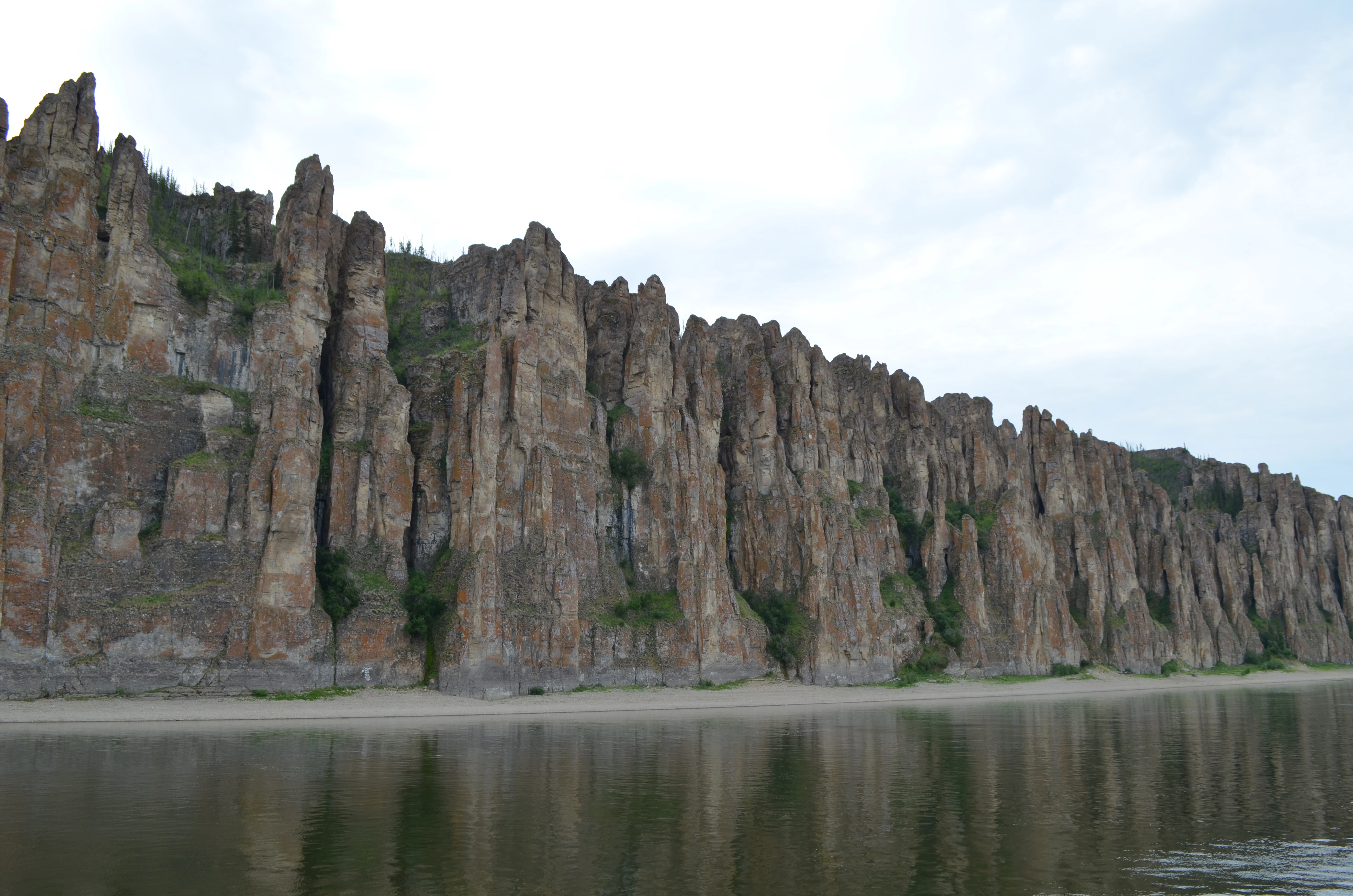
A long, sweeping view of the vertical rock pillars at Lena Pillars National Park, with a sandy riverbank at their base and the reflection of the rock face in the water of the Lena River.
The towering rock formations of the Lena Pillars rise vertically from the banks of the Lena River.

Lena Pillars National Park history and protected-area timeline

The rocks of the Lena Pillars themselves are ancient, yet the dramatic cliff forms that visitors see today are geologically quite young. The Cambrian limestones that form the pillars originated roughly 540 to 560 million years ago in a shallow tropical sea. Much later, the slow uplift of the Siberian Platform produced deep faults, and the Lena River carved a steep valley through the plateau. The recognizable cliffs emerged only within the last several hundred thousand years, as frost action, river erosion, and karst processes sculpted the limestone into pinnacles and ridges.

As a protected area, Lena Pillars has a more recent history. In 1994, the Sakha Republic (Yakutia) established a regional nature park named Lena Pillars, and this original park was formally brought under regional environmental administration in 1995. The regional park's territory was organized into two territorial units, known internally as Stolby and Sinsk, and its development was oriented toward ecological tourism alongside conservation.

In 2009, an initial nomination to the UNESCO World Heritage List was not accepted, but a revised nomination succeeded. On 2 July 2012, during the 36th session of the UNESCO World Heritage Committee held in Saint Petersburg, Lena Pillars was inscribed under natural criterion (viii), recognizing the outstanding geological value of the cliff complex. A national commemorative postage block issued by the Russian Post mark in 2015 reflects the cultural prominence the site had already gained within Russia.

In 2018, the territory was upgraded and redesignated as a national park of the Russian Federation, with the current name Lena Pillars National Park and a federal managing institution responsible for its administration. This change aligned the protected area with Russia's national parks system while preserving its existing regional character and UNESCO recognition.

Lena Pillars National Park landscape and geographic character

The defining landscape feature of the park is a long belt of vertical limestone cliffs running parallel to the Lena River. These cliffs rise sharply from the river's edge and the forested slopes below, presenting a continuous wall broken by isolated pillars, ridges, and pinnacles. Viewed from the river, the formations appear as an almost uninterrupted line of stone sentinels, with vertical fractures, overhangs, and weathered surfaces that give the complex its distinctive silhouette.

This dramatic river-facing face sits at the edge of the Prilenskoye Plateau, a broad upland that forms part of the larger Siberian Platform. The plateau surface above the cliffs is more gently rolling, while the eastern and southern portions of the park preserve a mosaic of typical central Yakutian landscape: taiga stretches of larch and pine, low river terraces, broad sand massifs, and lake depressions. The Lena deepens and widens as it flows through the park area, and its waters form the main scenic and ecological axis for the entire protected territory.

In several places, the park contains tukulans, which are active or semi-active sand massifs that contrast sharply with the surrounding forest and rock. These sands are sometimes described as cold northern desert fragments and represent an unusual inland dune landscape in the otherwise heavily forested region. The combined effect of plateau, cliff, river, taiga, and dune creates a visually varied terrain that is rare at such latitudes.

A Siberian tiger lying in profile on bare earth, facing left.
A Siberian tiger resting on the ground.

Lena Pillars National Park ecosystems, habitats, and plant life

The vegetation of the park reflects its position deep within the central Yakutian taiga. The dominant forest cover is composed of cold-hardy boreal species, primarily larch, with pine and other conifers contributing to the canopy on better-drained sites. The climate of the region is strongly continental, with very cold winters, comparatively short and warm summers, and widespread permafrost, which shapes both the composition of plant communities and the distribution of wetlands and mosses.
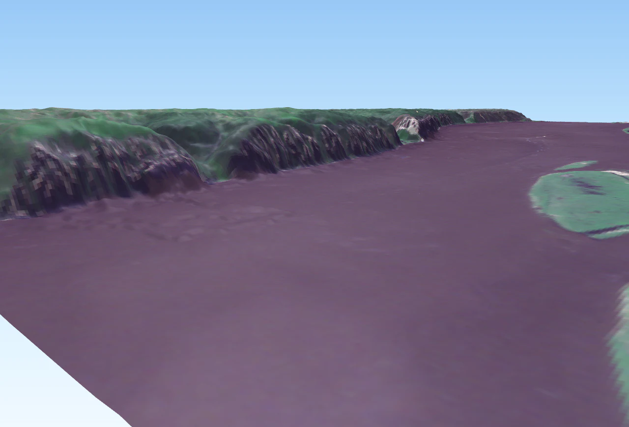
A 3D satellite visualization shows the Lena Pillars, consisting of high, jagged rock faces rising from the banks of a wide, dark-colored river.
A 3D perspective visualization of the Lena Pillars geological formations along the Lena River, derived from satellite imagery.

Lena Pillars National Park wildlife and species highlights

The park supports a typical central-Yakutian boreal mammal fauna, including brown bear, lynx, wolf, red fox, sable, least weasel, moose, Siberian roe deer, mountain hare, and red squirrel, along with several other smaller forest species. Wetland and river habitats support waterfowl and shorebirds, and the broader park territory provides seasonal habitat for migratory bird species in addition to resident breeders. Cold-adapted freshwater fish inhabit the Lena and its tributaries within the park boundaries, completing a vertebrate profile typical of subarctic river landscapes.

Lena Pillars National Park conservation status and protection priorities

Lena Pillars is significant from a conservation standpoint primarily because of its geology. The Cambrian limestone formations exposed along the Lena River are widely regarded as one of the most important exposures of Cambrian strata anywhere in the world, and they provide a near-continuous record of early Paleozoic carbonate environments. This geological value has been formally recognized through the site's 2012 inclusion in the UNESCO World Heritage List under the natural criterion.

Beyond the geological resource, the park safeguards a large intact block of central Yakutian taiga and permafrost terrain. The continuity of natural forest, riverbank habitat, permafrost-sensitive ecosystems, and unusual inland sand formations within a single protected area is an important feature for ecosystem-level conservation. The park's management framework is also notable for its integration of conservation with the limited traditional land use of Indigenous Evenki communities, including their historical hunting and fishing practices within delineated community territories.

Lena Pillars National Park cultural meaning and human context

The territory has long been inhabited and used by the Evenki people, whose traditional communities continue to maintain limited land uses such as hunting and fishing within defined areas of the park. Park administration formally recognizes the boundaries of community territories and accommodates coexistence between conservation objectives and these traditional practices.

In addition to its Indigenous heritage, the area has yielded important archaeological evidence of early human presence. The Diring-Yuryakh site, located in the park near a small tributary of the Lena, has produced stone tools attributed to the Diring culture and is widely cited as evidence of very early occupation of northeastern Siberia. Later burial evidence belongs to the Ymyyakhtakh culture of the Late Neolithic. Together with relict Pleistocene fauna such as woolly mammoth, steppe bison, and woolly rhinoceros found in the area, these finds add a deep archaeological and paleoenvironmental dimension to the park's cultural profile.

Top sights and standout views in Lena Pillars National Park

The Lena Pillars cliffs themselves are the park's clearest highlight: a long wall of vertically fractured Cambrian limestone that rises sharply above the Lena River within the Prilenskoye Plateau.

The wider territory adds several complementary features: cold sand-dune tukulans that look almost like miniature northern deserts embedded in the taiga, large tracts of intact larch-dominated boreal forest, important Ice Age paleontological exposures, the Diring-Yuryakh early-human archaeological site, and the river itself as a continuous ecological and scenic axis. Inscribed in the UNESCO World Heritage List in 2012 and reorganized as a Russian national park in 2018, the park is now both a natural heritage site and a formally protected federal area.

Best time to visit Lena Pillars National Park

Central Yakutia has one of the most extreme continental climates on Earth, with bitterly cold winters and comparatively warm but short summers. Most visitors experience the Lena Pillars during the summer navigation season, when the Lena River is free of ice, the river cliffs are accessible by boat, and the surrounding taiga is in full leaf. Late spring and early autumn can offer quieter conditions and striking light on the cliffs, though colder temperatures arrive quickly once the season turns. Winter visits are possible but require planning around extreme cold and ice on the river.

Monthly climate preview

Long-term temperature and precipitation patterns across the representative coordinate

Lena Pillars National Park Climate Normals and Monthly Weather Records

Historical climate data reveals extreme seasonal shifts in average temperature and monthly precipitation across the representative coordinate for Lena Pillars National Park. Reviewing the complete twelve-month normals provides deeper context on long-term weather variations and regional meteorological baselines.
Annual mean-7 °C
-32 °C18 °C
Jan-32°
Feb-29°
Mar-18°
Apr-6°
May
Jun15°
Jul18°
Aug15°
Sep
Oct-7°
Nov-23°
Dec-32°
Warmest month
July

18.3 °C

Coolest month
December

-32.1 °C

Wettest month
June

2.5 mm/day

Driest month
February

0.4 mm/day

Park location guide

Geography guide, regional context, and park location map for Lena Pillars National Park

Lena Pillars National Park park geography, regions, and map view in Russia

Understand where Lena Pillars National Park sits in Russia through a broader geographic reading of the surrounding landscape, nearby location context, and its mapped position within the national park landscape.

How Lena Pillars National Park fits into Russia

Russia is a transcontinental nation spanning eleven time zones, bordered by fourteen countries. It is the world's largest country by area, covering 17,098,246 km². Moscow is the capital and largest city, while Saint Petersburg is the second-largest and a major cultural centre.

Wider geography shaping Lena Pillars National Park in Russia

Russia spans Eastern Europe and North Asia, covering 17,098,246 km². It shares land borders with fourteen countries, more than any other nation, and spans eleven time zones. The landscape includes vast plains, mountain ranges such as the Urals and Caucasus, and extensive coastlines along the Arctic Ocean, Pacific Ocean, Baltic Sea, Black Sea, and Caspian Sea.

Map view of Lena Pillars National Park

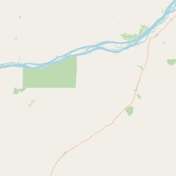
Use this park location map to pinpoint Lena Pillars National Park in Russia, understand its exact geographic position, and read its mapped placement within the surrounding landscape more clearly.

Pigeon | © OpenStreetMap contributors

Location context for Lena Pillars National Park

Sakha Republic

Visualizing limestone cliffs, boreal taiga forests, and Arctic river canyons

Lena Pillars National Park Photos and Protected Landscape Scenery

Visual records capture the striking vertical limestone cliffs and vast taiga ecosystems that define Lena Pillars National Park. Studying these protected area photographs reveals the unique geological formations and remote river terrain shaping the Siberian Platform.

A long, sweeping view of the vertical rock pillars at Lena Pillars National Park, with a sandy riverbank at their base and the reflection of the rock face in the water of the Lena River.

Wide landscape shot of the tall vertical rock formations of Lena Pillars overlooking a wide river under a cloudy sky.

A Siberian tiger lying in profile on bare earth, facing left.

A 3D satellite visualization shows the Lena Pillars, consisting of high, jagged rock faces rising from the banks of a wide, dark-colored river.

Park atlas

Compare regional geography, boreal forest terrain, and connected Siberian protected areas

Explore Parks Near Lena Pillars National Park and Surrounding Protected Landscapes

Continue browsing other parks near Lena Pillars National Park to examine shared Siberian Plateau terrain and protected river valleys. Compare regional protected areas and geological monuments across the surrounding taiga and permafrost landscapes.
Watercolor illustration showing green hills, a river, and grassy foreground
Nature reserveSakha Republic
Park boundaries overlap#1 closest

East

Lena Pillars Nature Reserve: Mapped Protected Area in Sakha Republic's Vast Geography

Explore the regional landscape and park boundaries.

Discover Lena Pillars Nature Reserve, a key protected area located within the expansive Sakha Republic of Russia. This page offers focused atlas exploration, detailing the park's geographic setting and its mapped boundaries against the backdrop of Siberia's largest federal subject. Understand the unique natural landscape context and its significance within regional conservation efforts, providing structured geographic data for your exploration.

Area
13,870 km²
IUCN
II
Relief
Lowland
Climate
Subpolar
National parkAmur Oblast
About 625 km away#2 closest

South

Tokinsko-Stanovoy National Park: Protected Landscape Geography and Atlas Context

National Park in Amur Oblast, Russia

Delve into the specifics of Tokinsko-Stanovoy National Park, a designated national park within Amur Oblast. This entry provides essential context on its protected landscape characteristics and its place in the regional geography. Understand the park's mapped boundaries and discover its natural terrain as part of a larger atlas-driven exploration of protected areas in the Russian Far East.

Area
2,430 km²
Established
2019
IUCN
II
Relief
Mountain
Watercolor illustration showing a river winding through a valley with mountains and forests
National parkZabaykalsky Krai
About 695 km away#3 closest

Southwest

Kodar National Park: Geographic Map & Protected Landscape Analysis

Analyzing alpine terrain and Siberian taiga ecosystems

Kodar National Park presents a striking array of Siberian ecosystems, including the northernmost desert environment known as the Chara Sands, extensive taiga forests, and rugged volcanic terrain on the Udokan Plateau. This geographic resource details the park's distinct sectors, tracing the boundaries of its alpine cirques, glaciers, and mountainous corridors that characterize the Zabaykalsky Krai landscape.

Area
4,917 km²
Established
2016
IUCN
II
Relief
Mountain
Watercolor painting of a mountain range with green foothills and a central valley, set against a plain white background.
National parkZabaykalsky Krai
About 729 km away#4 closest

Southwest

Kodar National Park: Geography and Protected Wilderness in Zabaykalsky Krai

Mapped mountain taiga and alpine ranges of Siberia

Kodar National Park is a federally protected area in southern Siberia, defined by its rugged alpine peaks and expansive mountain taiga forests. Centered on the Kodar Range, this protected region offers an essential look at the subarctic ecosystems, rare high-altitude flora, and river corridors of Zabaykalsky Krai. Users can examine the park's two-cluster configuration and its role as a remote stronghold for endemic species within the broader Russian Far East.

Area
4,917.1 km²
Established
2018
IUCN
II
Relief
Mountain
National parkKhabarovsk Krai
About 897 km away#5 closest

Southeast

Shantar Islands National Park: Remote Archipelago Atlas with Rugged Terrain

Mapping protected marine and island geography in Khabarovsk Krai.

Shantar Islands National Park represents a significant protected landscape within Khabarovsk Krai, notable for its dramatic coastal geography, mountainous terrain, and rich marine ecosystems. This national park, encompassing a chain of islands in the Sea of Okhotsk, is a vital habitat for marine mammals and seabird colonies. Explore its mapped boundaries and unique regional atlas context, understanding its role as a protected coastal area in the Russian Far East.

Area
5,155 km²
Established
2013
IUCN
II
Relief
Mountain
Watercolor painting depicting a lake with mountain ranges, green hills, and scattered trees.
National parkBuryatia
About 1,352 km away#6 closest

Southwest

Zaybaykalsky National Park: Geographic Atlas of Lake Baikal Protected Terrain

Mapping the Svyatoy Nos peninsula and Barguzin mountain landscapes

Spanning over 269,000 hectares, Zaybaykalsky National Park protects a dramatic transition from the shores of Lake Baikal to high-altitude mountain complexes. This atlas resource details the park's steep topography, characterized by ancient taiga forests and geological features like the Academician Ridge and marble-limestone islands, offering a structured view of this significant Siberian protected area.

Area
2,690 km²
Established
1986
IUCN
II
Relief
Mountain
National parkBuryatia
About 1,352 km away#7 closest

Southwest

Zabaykalsky National Park: Geographic and Protected Area Mapping for the Eastern Baikal Shore

Mountain taiga, islands, and protected peninsula landscapes.

Zabaykalsky National Park comprises an extensive area of the eastern Baikal shoreline, characterized by the Barguzin Range, the prominent Sviatoy Nos peninsula, and a dense network of mountain taiga forests. Its protected boundaries include diverse mineral springs, karst features, and crucial marine habitats, providing a comprehensive look at the unique geomorphology and biodiversity of this Siberian wilderness.

Area
2,690 km²
Established
1986
IUCN
II
Relief
Mountain
National parkSakha Republic
About 1,403 km away#8 closest

Northeast

Kytalyk National Park: Arctic Tundra Geography and Protected Siberian Wilderness

Exploration of permafrost terrain in the Sakha Republic

Situated in the Sakha Republic, Kytalyk National Park protects nearly 1.9 million hectares of low-lying Arctic coastal tundra. The park provides an essential look at intact polar environments, featuring thermokarst landforms, extensive peat bogs, and critical nesting grounds for migratory bird species across the Siberian landscape.

Area
18,856 km²
Established
2020
IUCN
II
Relief
Lowland

Common questions about visiting, size, designation, and location context for Lena Pillars National Park

Lena Pillars National Park FAQs for park facts, access, geography, and protected area context

Find quick answers about Lena Pillars National Park, including protected-area facts, park geography, trail and visitor context, and how the park fits into its surrounding country and regional landscape.
MoriAtlas Explorer

Continue Your Protected Areas Search Across the Global Atlas

Deepen your exploration by continuing the structured search for national parks and protected areas worldwide. Utilize the comprehensive filtering capabilities to compare different conservation landscapes and refine your understanding of global park geography. Discover more about the distribution and characteristics of protected natural areas.

Global natural geography