


Mori Atlas logo
Wildlife reserveLoktak Lake

A detailed geographic exploration of the largest freshwater lake and unique phumdi wetland system in Northeast India

Loktak Lake Wildlife Reserve: Mapping the Geography and Floating Wetland Landscapes of Manipur

Loktak Lake is an expansive, pulsating freshwater wetland located in the Imphal Valley of Manipur, India. This protected wildlife reserve is defined by its extraordinary phumdis, which are floating mats of vegetation that drift across the lake surface and form a distinct semi-aquatic terrain. The region functions as a vital hydrological basin, with complex river channels and surrounding hillocks shaping the local geography and habitat distribution.

freshwater lakewetlandphumdisfloating islandsRamsar siteManipur
A flat vector-style illustration featuring a waterfall cascading off a red rock cliff into a lake with rounded green floating islands, surrounded by forest trees and pastel clouds.

Loktak Lake

Wildlife reserve

Park overview

Structured park overview, official facts, and landscape profile for Loktak Lake

Loktak Lake park facts, protected area profile, and essential visitor context

Review the core facts for Loktak Lake, including designation, size, terrain, visitor scale, habitats, and operating context in one park-focused overview.

About Loktak Lake

Loktak Lake occupies the southern portion of the Imphal Valley in Manipur, positioned at the lowest elevation in the basin so that the surrounding rivers and hill streams ultimately drain into it. Although the Manipur River system dominates the wider catchment, Loktak itself is fed by a network of smaller rivers and rivulets that descend from the hills fringing the valley. Open water, marshy margins, floating phumdis, and small hillocks together create a mosaic of habitats across the lake's surface.

What makes Loktak exceptional among freshwater lakes of South Asia is the scale and ecological role of its phumdis. These floating islands of intertwined vegetation, peat-like organic matter, and trapped sediment vary in thickness from under half a meter to several meters. The largest phumdi, on the southeastern shore, is itself large enough to host a national park. The interplay between open water, rooted aquatic vegetation, and drifting phumdi patches defines the lake's hydrology, ecology, and even cultural identity.

The lake has long been central to life in Manipur. Rural communities around Loktak depend on it for fishing, agriculture on the phumdi margins, and collection of edible plants such as lotus and water chestnut. Hydropower infrastructure at the Ithai Barrage regulates outflows, supporting power generation and irrigation across the valley. At the same time, these water management interventions have altered the lake's natural hydrology and intensified ecological pressures on what remains one of the most distinctive wetland landscapes in India.

Quick facts and research context for Loktak Lake

Loktak Lake is a freshwater lake in the Imphal Valley of Manipur, Northeast India, traditionally associated with the Meitei name "Loktak Pat." It was designated a Ramsar Wetland of International Importance on 23 March 1990 (site reference 463) and was later placed on the Montreux Record in 1993 due to ecological changes affecting the site. The lake's surface area pulses seasonally, expanding several-fold during the rainy season compared to drier months.

The lake is famous for phumdis, naturally occurring floating islands of vegetation and organic matter that drift on its surface, and for Keibul Lamjao National Park, the world's only floating national park, which lies on the largest phumdi. Loktak provides water for hydropower, irrigation, and domestic supply across Manipur and parts of neighboring states, and it supports roughly 100,000 people living in hamlets around its shoreline.

Protection and recognition

Documented protection history and official Ramsar designation records

Loktak Lake Protection Status and International Ramsar Recognition

Loktak Lake holds terrestrial protected area status established in 1990 alongside official Ramsar wetland recognition. Historical designation records outline the governance framework and international recognition sources associated with the landscape.

International recognition

Protection details

Protection scope
Terrestrial
Designated year
1990
Transboundary protection
No
Core area
70.3 km²
Park context

Deeper park guide and search-rich context for Loktak Lake

Loktak Lake history, landscape, wildlife, and travel context

Explore Loktak Lake through its history, landscape character, ecosystems, wildlife, conservation priorities, cultural context, and seasonal travel timing in a structured park guide built for atlas discovery and search intent.

Why Loktak Lake stands out

Loktak Lake is best known for its extraordinary floating islands, the phumdis, which are found nowhere else on this scale. These living mats of decomposing vegetation and soil drift across the lake and range from small clumps to formations covering tens of square kilometers. They sustain unique semi-aquatic microhabitats and have become the defining image of Loktak. The lake is equally famous for hosting Keibul Lamjao National Park on the largest phumdi, recognized as the only floating national park in the world. This park protects the Sangai, the Manipur brow-antlered deer, a subspecies of Eld's deer found nowhere else on Earth, and has become a powerful symbol of Loktak's ecological significance. Together, the phumdis and the Sangai deer define the lake's identity.
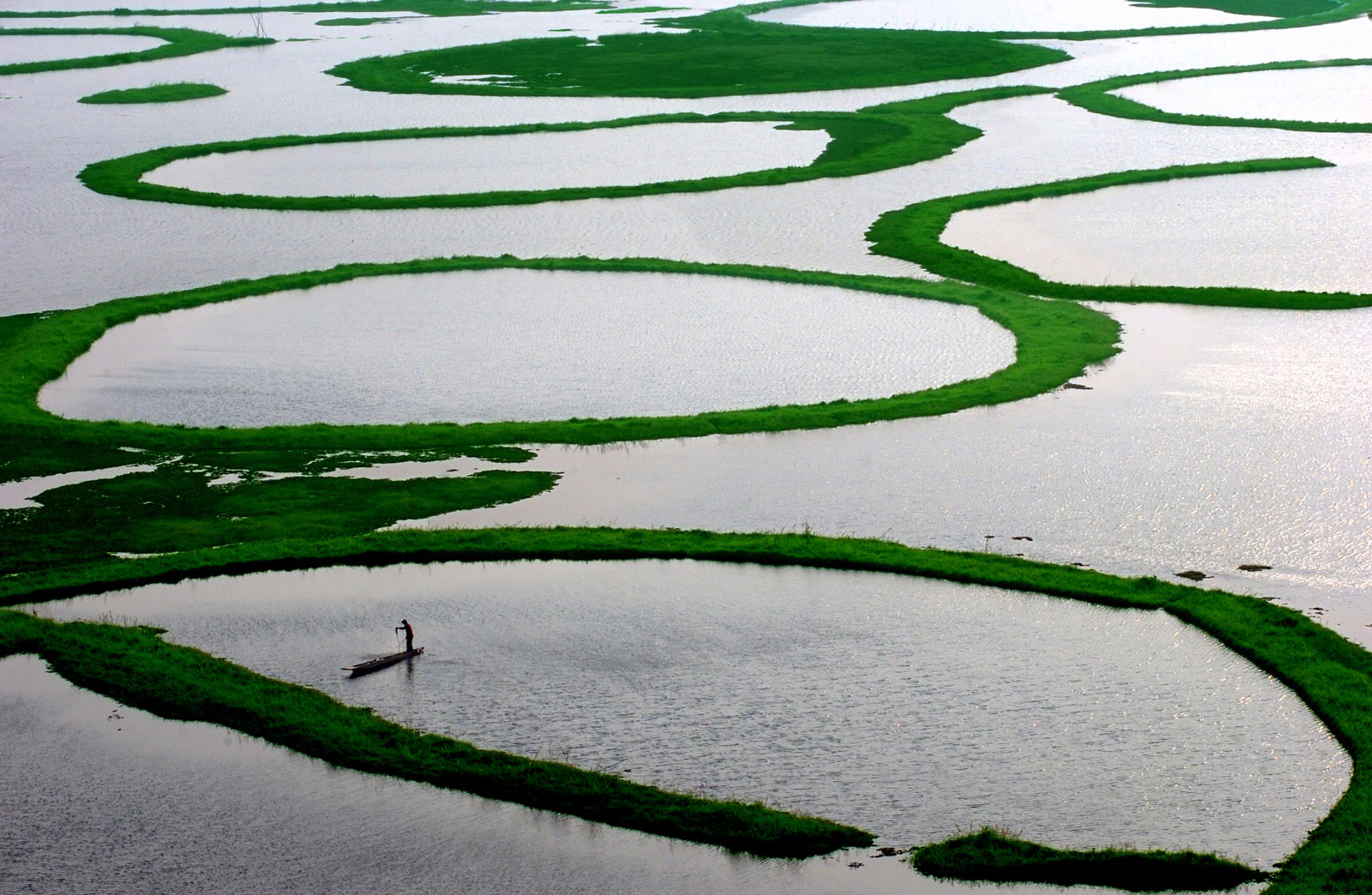
An aerial-style view of Loktak Lake featuring many large, circular patches of bright green floating vegetation, or phumdis, with a small boat carrying a person in one of the open water sections.
A lone fisherman navigates a small boat among the iconic circular phumdi vegetation on Loktak Lake.

Loktak Lake history and protected-area timeline

Loktak is described as an ancient lake, with a long-standing role in the cultural and ecological history of the Manipur Valley. Its name, in the Meitei language, combines "lok" (stream) and "tak" (the end), reflecting its position at the terminal point of the valley's drainage.

Modern management of the lake began to reshape its character in the late twentieth century. The Loktak Hydropower Project was built in 1983 on the Manipur River, with Loktak Lake serving as the headwater storage for power generation, irrigation, and water supply to multiple northeastern states. The Ithai Barrage at the lake's outlet became the key control structure, maintaining a regulated water level year-round. In recognition of its biological richness and ecological role, Loktak Lake was designated a Wetland of International Importance under the Ramsar Convention on 23 March 1990 (reference number 463). By 16 June 1993, ecological change at the site prompted its inclusion in the Montreux Record, which tracks Ramsar sites where adverse change has occurred or is likely to.

In response to mounting ecological concerns, the Government of Manipur established the Loktak Development Authority under the Manipur Loktak Lake (Protection) Act, 2006, with a mandate to administer, protect, conserve, and improve the natural environment of the lake. A detailed multi-year study jointly conducted with Wetlands International South Asia, supported by the India-Canada Environment Facility, produced recommendations on catchment management, sewage control, phumdi management, and resettlement of phumdi dwellers. In 2016, India's Ministry of Environment formed a dedicated panel to focus on preservation of the lake, reflecting its continued importance on the national conservation agenda.

Loktak Lake landscape and geographic character

Loktak Lake sits in a gently sloping basin at the lowest elevation of the Imphal Valley, ringed by low hills with elevations reaching roughly 768 meters above sea level at the lake surface. The terrain around the lake combines flat alluvial plains, low hillocks rising out of the water, and the surrounding slopes of the Manipur hills. Fourteen hills of varying size occur within or along the periphery of the lake, contributing to a distinctive backdrop of forested ridges behind broad open water.

The visual character of Loktak is unlike that of most large freshwater lakes. Instead of an unbroken sheet of water, the lake presents a patchwork of open water, marshy shallows, and floating phumdis. These phumdis range from small drifting clumps to vast, stable mats of vegetation and organic matter, some of which have been colonized by shrubs and small trees and even host villages. On the southern part of the lake, the islands of Thanga, Ithing, and Sendra provide further landscape variety, while phumdi "islands" like Keibul Lamjao feel almost terrestrial despite floating on water.

The catchment feeding Loktak is a mix of paddy fields, settlement areas, and remaining forest cover. River channels such as the Nambul, Nambol, Manipur (Imphal), Thoubal, Iril, Sekmai, and Khuga shape the inflow patterns, while small streams deposit silt and nutrients across the lake. The shallow average depth of the lake reinforces the impression of a vast wetland rather than a single deep body of water, particularly when phumdis proliferate and fragment the open surface.
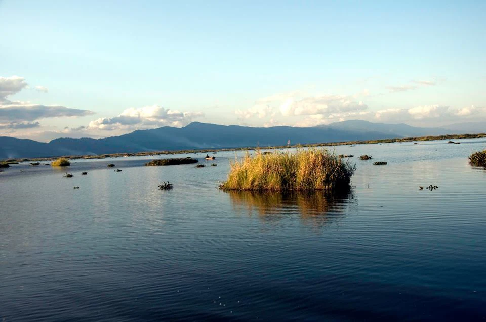
A wide scenic view of Loktak Lake with calm blue water, scattered floating islands of vegetation called phumdis, and mountain ranges in the distance under a pale blue sky.
A view of the floating phumdi vegetation on Loktak Lake in Manipur, India.

Loktak Lake ecosystems, habitats, and plant life

The ecological identity of Loktak Lake rests on its unusual combination of open freshwater, rooted aquatic plant beds, and floating phumdis. This habitat heterogeneity supports a rich community of aquatic macrophytes, including emergent species such as Phragmites karka, free-floating mats dominated by water hyacinth, and rooted floating-leaf communities that include lotus, water chestnut (Trapa natans), Euryale ferox, and several water lily species. These plant communities create distinct microhabitats across the lake.

The lake is broadly divided into a "Core Zone" that is fully protected and a surrounding buffer zone, and is also understood in terms of northern, central, and southern ecological regions. The northern zone is heavily shaped by phumdi burning and fish-farm development during the dry months; the central zone historically contained the largest expanses of open water but has seen increasing proliferation of artificially created circular phumdis known as athapums; and the southern zone includes the area around Keibul Lamjao National Park and channels like the Khordak and Ungamel that connect with surrounding rivers.

Catchment pressures have significantly altered the lake's ecological state. Heavy silt inflow from deforested and jhum-cultivated hills, combined with nutrient loading from Imphal's domestic sewage carried by the Nambul River, has driven widespread eutrophication. The resulting proliferation of phumdis, particularly water hyacinth-dominated mats, has changed the lake's biological balance, while diking and barrages have altered natural water-level fluctuations. Today, Loktak is recognized as one of the most ecologically stressed yet biologically distinctive wetlands in the Indian subcontinent.
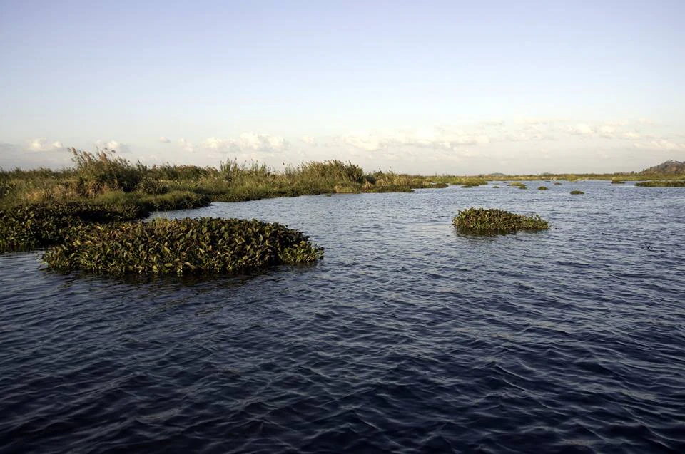
A wide view of Loktak Lake featuring floating vegetation islands known as phumdis scattered across the open water with a low horizon and soft sky.
Floating phumdi islands scattered across the waters of Loktak Lake in Manipur.

Loktak Lake wildlife and species highlights

Loktak Lake supports an exceptionally diverse vertebrate and invertebrate fauna, anchored by the wetland's role as a critical habitat for resident and migratory species. The lake has been recorded as hosting dozens of waterbird species alongside wetland-associated birds, with significant populations of migratory waterfowl arriving from across the Himalayas and beyond. Pheasant-tailed jacanas and bronze-winged jacanas are typical of the rooted floating-plant zones, while dabbling and diving ducks occupy remaining open water and raptors such as black kites and marsh harriers use the larger hillock trees.

On the phumdi fringes and within Keibul Lamjao National Park, mammal life is unusually rich for a wetland setting. The most iconic resident is the Sangai, the Manipur brow-antlered deer, a subspecies of Eld's deer found nowhere else and once believed to be extinct. The lake precincts also support Indian python, sambar, barking deer, wild boar, muntjac, rhesus macaque, stump-tailed macaque, and Hoolock gibbon in the forested patches, along with smaller carnivores such as Indian civet, marbled cat, and Temminck's golden cat in the surrounding landscape.

Fish are central to the lake's wildlife character and to its local economy. Traditional catches from Loktak have historically reached several thousand tonnes annually, supported by both capture fishery and culture-based practices. Natural local species such as the snakeheads and other indigenous fishes have declined as exotic carp species including grass carp and silver carp have been introduced; meanwhile, changes in phumdi cover and fish migration routes from Myanmar's Chindwin-Irrawaddy system have altered species composition throughout the lake.
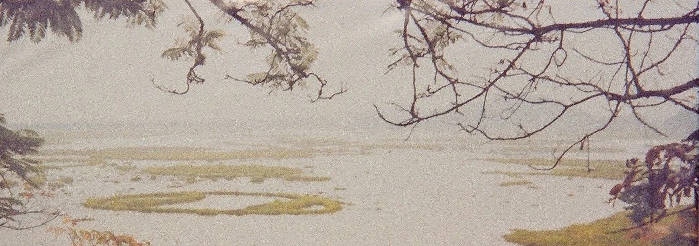
A panoramic landscape view of a vast, calm lake featuring numerous floating islands of vegetation, framed by overhanging tree branches in the foreground.
A wide view overlooking the floating vegetation, known as phumdis, on Loktak Lake.

Loktak Lake conservation status and protection priorities

Loktak Lake was designated a Wetland of International Importance under the Ramsar Convention on 23 March 1990 in recognition of its outstanding biodiversity and ecological functions in the Manipur Valley. Its inclusion in the Montreux Record in 1993 highlighted concerns about ongoing ecological change, and the lake continues to be a flagship example of a Ramsar site facing intense human pressure.

The lake's conservation significance is amplified by its role in protecting the Sangai deer within Keibul Lamjao National Park, the only floating national park in the world. The very existence of this subspecies depends on the persistence of a stable, thick phumdi mat capable of supporting deer movement and feeding; thinning of phumdis, habitat degradation, and changes in vegetation composition have placed the Sangai at serious risk and made the conservation of the lake inseparable from the conservation of this iconic species.

Beyond flagship species, conservation at Loktak addresses water quality, catchment erosion, sewage management, fisheries management, and the future of phumdi-dwelling communities. The Loktak Development Authority, established under the Manipur Loktak Lake (Protection) Act of 2006, coordinates restoration efforts, while recommendations from studies conducted with Wetlands International South Asia emphasize sewage treatment for the Nambul River, catchment-level soil conservation, resettlement planning for phumdi dwellers, and targeted phumdi management to safeguard both ecological function and human livelihoods.

Loktak Lake cultural meaning and human context

Loktak Lake is deeply woven into the identity of the Meitei people of Manipur. The lake's name itself derives from Meitei language roots meaning "stream" and "the end," reflecting how the lake marks the natural endpoint of the valley's drainage. Annual observances such as Loktak Day, held every 15 October around the lake's periphery, reflect continuing cultural attachment to the wetland.

Traditional livelihoods around the lake are closely tied to phumdis and to the lake's aquatic resources. Communities living on phumdi mats and along the shoreline practice fishing, fish-cum-paddy cultivation on constructed phumdis, and the harvest of edible plants such as lotus fruits, lotus rhizomes, and Euryale ferox. These practices are not only economic activities but part of a long-standing relationship between local communities and the lake's unique floating landscape.
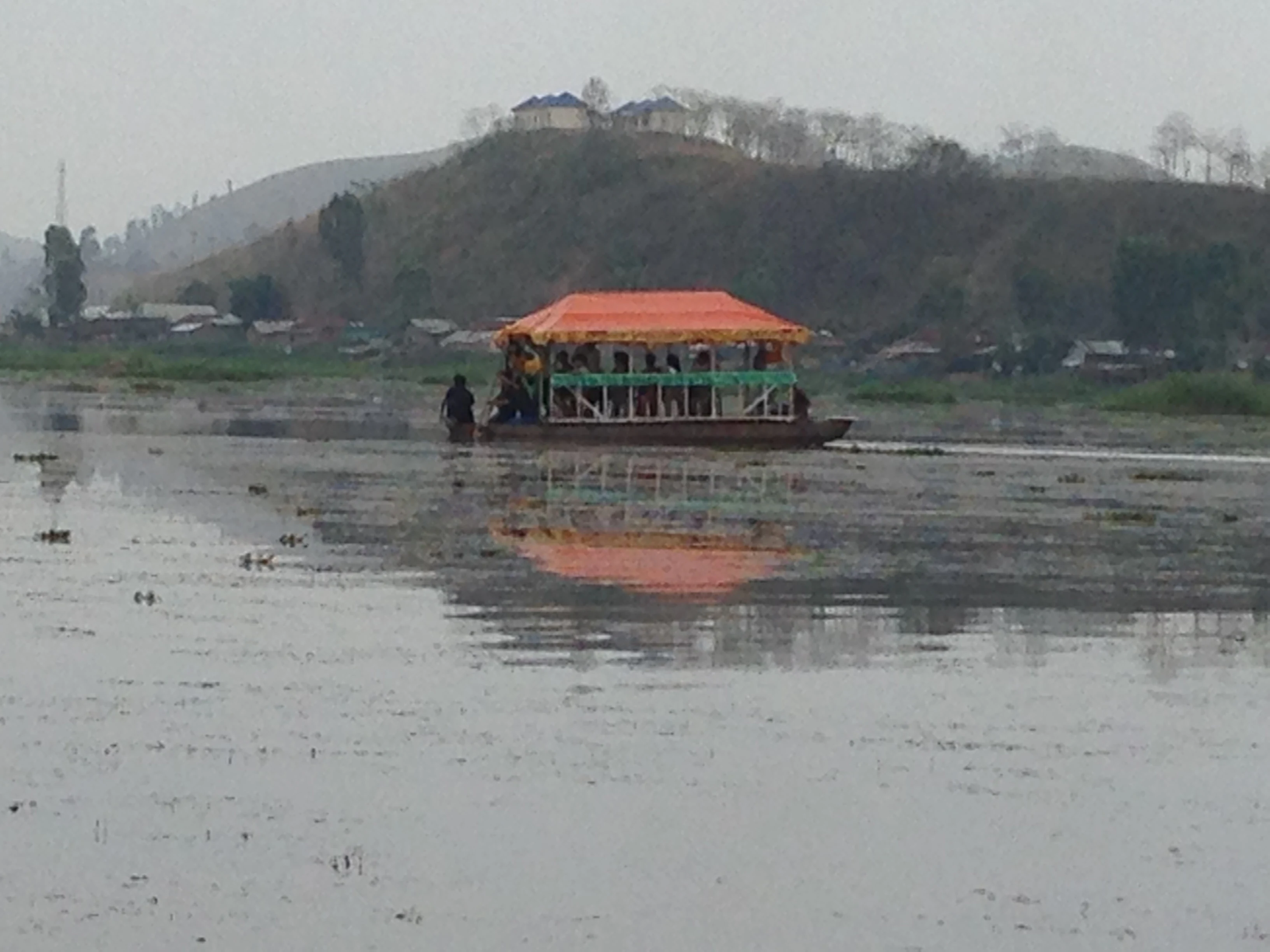
A passenger boat with an orange canopy traveling across a calm, flat, grey lake with hills in the background.
A boat cruising on the waters of Loktak Lake.

Top sights and standout views in Loktak Lake

Loktak Lake's most distinctive feature is the extraordinary phumdi ecosystem, where floating mats of vegetation and organic matter form living islands that drift across a vast freshwater lake. The largest of these phumdis hosts Keibul Lamjao National Park, recognized worldwide as the only floating national park and as the last refuge of the Sangai deer, a globally rare subspecies of Eld's deer.

Equally notable is the lake's Ramsar status and its Montreux Record listing, which together place Loktak among the most ecologically recognized yet most threatened wetlands in India. The lake's scale, its pulsing seasonal surface area, and its role in hydropower, irrigation, fisheries, and the daily lives of tens of thousands of surrounding residents make it a junction of ecological, economic, and cultural importance.
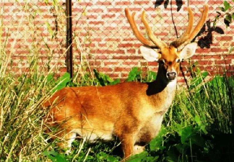
A Sangai deer with distinctive branching antlers stands in tall grass in front of a brick wall and wire fence.
A Sangai deer, the endemic brow-antlered deer of Keibul Lamjao National Park.

Best time to visit Loktak Lake

Loktak Lake is most distinctive during the post-monsoon period, from roughly October through February, when the surrounding hills are green, water levels are high but manageable, and migratory waterfowl from across the Himalayas arrive at the lake. The cooler months offer clearer skies for viewing the lake's open-water zones and the phumdi landscapes, which are most photogenic when phumdi vegetation is mature.

The wet months from June through September bring the lake's surface area to its largest extent and intensify its pulsating character, but access and visibility can be limited by heavy rain. February and March are the driest months in the valley, with the lowest temperatures, and can also provide rewarding conditions for birdwatching and for observing the phumdi communities at lower water levels.
Monthly climate preview

Long-term temperature ranges and monthly precipitation cycles across the representative coordinate

Loktak Lake Climate Normals and Annual Weather Patterns in Manipur

Representative coordinates record measured annual temperature variations alongside monthly precipitation cycles from NASA data. Complete twelve-month climate profiles provide deeper analytical context for long-term regional weather patterns.
Annual mean21 °C
15 °C25 °C
Jan15°
Feb17°
Mar21°
Apr23°
May25°
Jun25°
Jul25°
Aug25°
Sep24°
Oct22°
Nov19°
Dec16°
Warmest month
June

25 °C

Coolest month
January

14.5 °C

Wettest month
June

6.4 mm/day

Driest month
January

0.3 mm/day

Park location guide

Geography guide, regional context, and park location map for Loktak Lake

Loktak Lake park geography, regions, and map view in India

Understand where Loktak Lake sits in India through a broader geographic reading of the surrounding landscape, nearby location context, and its mapped position within the national park landscape.

How Loktak Lake fits into India

India is a South Asian country bordered by the Indian Ocean, Arabian Sea, and Bay of Bengal. It shares land borders with Pakistan, China, Nepal, Bhutan, Bangladesh, and Myanmar. The country has a population of over 1.4 billion people and operates as a federal parliamentary republic with its capital in New Delhi.

Wider geography shaping Loktak Lake in India

India occupies the Indian subcontinent in South Asia, bordered by the Arabian Sea to the southwest, the Bay of Bengal to the southeast, and the Indian Ocean to the south. It shares land borders with Pakistan to the west, China, Nepal, and Bhutan to the north, and Bangladesh and Myanmar to the east. The territory also includes the Andaman and Nicobar Islands in the Indian Ocean.

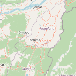
Map view of Loktak Lake

Use this park location map to pinpoint Loktak Lake in India, understand its exact geographic position, and read its mapped placement within the surrounding landscape more clearly.

Pigeon | © OpenStreetMap contributors

Location context for Loktak Lake

Manipur

Visualizing the floating phumdis and wetland habitats of Northeast India

Loktak Lake Landscape and Scenery Photography

Visual documentation of Loktak Lake reveals the shifting topography of floating vegetation mats, open water channels, and surrounding hill ridges. Studying these protected area views provides deeper insight into the rare semi-aquatic microhabitats and wetland ecosystems of Manipur.

An aerial-style view of Loktak Lake featuring many large, circular patches of bright green floating vegetation, or phumdis, with a small boat carrying a person in one of the open water sections.

An elevated, wide-angle view of Loktak Lake in India, showing numerous small fishing boats among unique, circular floating patches of green vegetation called phumdis.

A wide scenic view of Loktak Lake with calm blue water, scattered floating islands of vegetation called phumdis, and mountain ranges in the distance under a pale blue sky.

A wide view of Loktak Lake featuring floating vegetation islands known as phumdis scattered across the open water with a low horizon and soft sky.

A panoramic landscape view of a vast, calm lake featuring numerous floating islands of vegetation, framed by overhanging tree branches in the foreground.

A high angle shot looking over a large, calm lake with numerous circular patches of floating vegetation, or phumdis, dotted across the water, set against a backdrop of rolling hills under a clear sky.

A passenger boat with an orange canopy traveling across a calm, flat, grey lake with hills in the background.

A Sangai deer with distinctive branching antlers stands in tall grass in front of a brick wall and wire fence.

Park atlas

Compare regional protected landscapes and wetland reserves across the surrounding Manipur terrain.

Explore Parks Near Loktak Lake and Related Protected Areas

Browse neighboring protected areas and regional reserves to compare the wetland ecology surrounding Loktak Lake. Extending the geographic review provides a broader understanding of the natural valley terrain and regional conservation networks.
National parkManipur
About 5.8 km away#1 closest

South

Keibul Lamjao National Park: Mapped Boundaries and Protected Landscape Identity

Explore Manipur's unique national park geography and terrain.

Keibul Lamjao National Park represents a key protected area within the state of Manipur, India, offering critical insights into regional geography and protected landscape dynamics. This national park's unique environmental setting provides an excellent opportunity for structured atlas exploration, allowing users to understand its mapped boundaries and its significance within the subcontinent's network of conservation areas. Discover the specific geographic context and natural terrain that define Keibul Lamjao National Park.

Area
40 km²
Established
1977
IUCN
II
Relief
Lowland
National parkManipur
About 58 km away#2 closest

Southeast

Shirui National Park: Detailed Protected Landscape and Regional Geography in Manipur

Mapped boundaries and atlas context for this national park.

Shirui National Park serves as a vital protected area within the state of Manipur, offering a unique focal point for geographic exploration. This profile details its identity as a national park, emphasizing its mapped boundaries and landscape context. For users interested in atlas-based discovery and understanding the distribution of protected lands, Shirui National Park provides critical data on regional geography and conservation. Examine its position within India's natural terrain and protected area network.

Area
41.3 km²
Established
1982
IUCN
II
Relief
Mountain
National parkChamphai
About 114 km away#3 closest

Southwest

Murlen National Park: Mapped Protected Landscape and Regional Geographic Context

National Park discovery in Champhai, India.

Delve into the specifics of Murlen National Park, a key protected area situated in the Champhai region. This entry focuses on its identity as a National Park, providing critical information about its geographic placement and mapped boundaries. Understanding Murlen National Park within its regional landscape context is fundamental for comprehensive atlas-based exploration of India's protected areas.

Area
200 km²
Established
1991
IUCN
II
Relief
Mountain
National parkIndia
About 117 km away#4 closest

North

Intanki National Park: An Atlas Perspective on India's Protected Landscape

Mapping the boundaries and regional geography of this national park.

Delve into Intanki National Park, a significant protected area within India, through an atlas and map-focused lens. This detail page provides insights into its protected landscape identity, geographic setting, and the broader context of natural terrain found in India. Understand its specific placement and role within the national park system, offering a foundation for detailed geographic study and exploration.

Wildlife reserveAssam
About 126 km away#5 closest

Northwest

Borail Wildlife Sanctuary: Protected Evergreen Forest Landscapes in the Barail Range

Exploring the terrain and habitat boundaries of southern Assam

Borail Wildlife Sanctuary spans the transition from the Surma valley floor to the hill country of the Barail range. This protected area serves as a critical refuge for primates, hornbills, and endemic plant species. The sanctuary offers a mapped look at one of the most ecologically significant, forest-covered landscapes in the Barak valley region, defined by steep ridges and monsoon-fed stream networks.

Area
326.24 km²
Established
2004
IUCN
IV
Relief
Mountain
Wildlife reserveAssam
About 157 km away#6 closest

North

East Karbi-Anglong Wildlife Sanctuary: Geographic Overview and Hill Forest Map

Protected wildlife reserve within the Karbi Anglong district of Assam.

The East Karbi-Anglong Wildlife Sanctuary occupies a significant portion of the Karbi Anglong plateau, encompassing 222 square kilometers of rolling hills and narrow valleys. This protected area supports a mosaic of forest habitats, ranging from moist evergreen patches to drier deciduous ridges. It functions as an essential refuge for tigers, elephants, and primates, while maintaining a rich avian community of approximately 250 recorded species.

Area
221.81 km²
Established
2000
IUCN
IV
Relief
Upland
Watercolor painting showing grasses in the foreground, a body of water, and hilly terrain under a pale sky
National parkSylhet District
About 192 km away#7 closest

West

Khadim Nagar National Park: Bangladesh National Park with Sylhet District Geographic Context

Mapped protected landscape and regional park identity.

Khadim Nagar National Park stands as a significant national park within Sylhet District, Bangladesh, offering a focused point for understanding protected land distribution and geographic features. This entry serves as a resource for exploring the park's specific boundaries and its role within the larger atlas of natural landscapes. Users can gain a clear view of its protected status and its place within the regional geography, facilitating detailed park exploration.

Area
6.79 km²
Established
2006
IUCN
II
Relief
Mixed relief
National parkMoulvibazar District
About 204 km away#8 closest

West

Lawachara National Park: Protected National Park Landscape in Moulvibazar District

Mapped Terrain and Endangered Primate Habitat Exploration

Delve into the protected landscape of Lawachara National Park, a key national park located in the distinct undulating terrain of Moulvibazar District, Bangladesh. This area is recognized for its ecological significance, particularly as a sanctuary for endangered primates, including the critically important western hoolock gibbon population. Users can explore the park's mapped boundaries, understand its semi-evergreen forest ecosystem, and appreciate its geological features like sandstone hillocks and sandy-bedded streams, making it a valuable point of discovery for regional geography and conservation landscapes.

Area
12.5 km²
Established
1996
IUCN
II
Relief
Upland

Common questions about visiting, size, designation, and location context for Loktak Lake

Loktak Lake FAQs for park facts, access, geography, and protected area context

Find quick answers about Loktak Lake, including protected-area facts, park geography, trail and visitor context, and how the park fits into its surrounding country and regional landscape.
MoriAtlas Explorer

Continue Your Protected Areas Search Across the Global Atlas

Deepen your exploration by continuing the structured search for national parks and protected areas worldwide. Utilize the comprehensive filtering capabilities to compare different conservation landscapes and refine your understanding of global park geography. Discover more about the distribution and characteristics of protected natural areas.

Global natural geography
