
Mori Atlas logo
National parkLonga-Mavinga National Park

Discover the mapped boundaries and regional geographic context of this protected area.

Longa-Mavinga National Park: Angola's Protected Landscape and National Park Atlas

Longa-Mavinga National Park represents a significant protected landscape within Angola, offering a unique focus for atlas exploration and geographic discovery. This entry provides detailed context on its protected area identity, mapped boundaries, and its place within the broader natural terrain of Angola. Understand how this national park contributes to the regional geography and conserves its specific landscape character.

AngolaNational ParkSouthern AfricaProtected Area

Longa-Mavinga National Park

National park

Park overview

Structured park overview, official facts, and landscape profile for Longa-Mavinga National Park

Longa-Mavinga National Park park facts, protected area profile, and essential visitor context

Review the core facts for Longa-Mavinga National Park, including designation, size, terrain, visitor scale, habitats, and operating context in one park-focused overview.
Monthly climate preview

Track long-term monthly temperature and precipitation rhythms across the protected landscape

Longa-Mavinga National Park Climate Normals and Annual Temperature Patterns

Representative coordinates record sustained seasonal variations in average temperature and precipitation across twelve measured months for Longa-Mavinga National Park. Examining the complete monthly climatology profile reveals deeper multi-month thermal ranges and precipitation shifts for this protected area.
Annual mean23 °C
17 °C28 °C
Jan24°
Feb23°
Mar23°
Apr23°
May20°
Jun18°
Jul17°
Aug21°
Sep25°
Oct28°
Nov26°
Dec25°
Warmest month
October

27.9 °C

Coolest month
July

17.4 °C

Wettest month
January

6.5 mm/day

Driest month
July

0 mm/day

Park location guide

Geography guide, regional context, and park location map for Longa-Mavinga National Park

Longa-Mavinga National Park park geography, regions, and map view in Angola

Understand where Longa-Mavinga National Park sits in Angola through a broader geographic reading of the surrounding landscape, nearby location context, and its mapped position within the national park landscape.

How Longa-Mavinga National Park fits into Angola

Angola is a unitary presidential republic on the western coast of Southern Africa. Gaining independence from Portugal in 1975, it borders Namibia, the Democratic Republic of the Congo, Zambia, and the Atlantic Ocean. The country has an exclave province called Cabinda. With a population of over 36 million, Angola is rich in oil and mineral resources.

Wider geography shaping Longa-Mavinga National Park in Angola

Angola is located on the western coast of Southern Africa along the Atlantic Ocean. It is bordered by Namibia to the south, the Democratic Republic of the Congo to the north, Zambia to the east, and the Atlantic Ocean to the west. The country includes the exclave province of Cabinda, which borders the Republic of the Congo and the Democratic Republic of the Congo. The terrain includes coastal lowlands, highland plateaus, and interior plains.

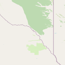
Map view of Longa-Mavinga National Park

Use this park location map to pinpoint Longa-Mavinga National Park in Angola, understand its exact geographic position, and read its mapped placement within the surrounding landscape more clearly.

Pigeon | © OpenStreetMap contributors
Park atlas

Compare regional protected landscapes and mapped geography surrounding Longa-Mavinga National Park in Angola.

Explore Related National Parks and Protected Areas Near Longa-Mavinga National Park

Browse other national parks and protected areas situated near Longa-Mavinga National Park, exploring the diverse conservation landscapes of Angola and its surrounding Southern African region. This curated view allows you to compare their geographic spread, ecological features, and protected status, aiding deeper atlas-style park discovery.
National parkAngola
Mapped location lies within the park boundary#1 closest

Mavinga National Park: Protected Landscape Identity and Geographic Mapping in Angola

Explore mapped boundaries and regional context of this national park.

Mavinga National Park stands as a designated protected area within Angola, offering insights into the nation's natural landscapes and conservation efforts. This entry details the park's geographic footprint and its role as a national park. It provides users with essential map-based discovery tools to understand the park's setting, its physical geography, and its significance as a protected natural landscape in southern Africa.

Area
46,076 km²
Established
2011
IUCN
II
Relief
Lowland
National parkAngola
About 56 km away#2 closest

East

Luengue-Luiana National Park: Angola's Premier Protected Woodland and Floodplain Ecosystem

Mapping crucial habitats for large mammals and avian wildlife.

Luengue-Luiana National Park is a vital protected landscape in southeastern Angola, covering an immense area that transitions from open woodland ecosystems to vast, seasonal floodplain grasslands. As a cornerstone of the Kavango-Zambezi Transfrontier Conservation Area, it facilitates critical wildlife movements and supports significant populations of large mammals. Its geography provides essential habitat, particularly within the extensive wetland wilderness and riparian zones along the Cuando River, making it a significant site for regional biodiversity and atlas exploration.

Area
42,000 km²
Established
2011
IUCN
II
Relief
Lowland
National parkZambezi Region
About 240 km away#3 closest

Southeast

Bwabwata National Park: National Park in the Zambezi Region, Namibia

Explore savanna ecosystem and riverine landscapes.

Bwabwata National Park represents a significant protected landscape in Namibia's Zambezi Region, notable for its integrated community conservation model and its function as a vital wildlife corridor. This national park spans the Caprivi Strip, featuring savanna woodlands and crucial riparian zones along the Okavango and Kwando rivers. As a key component of the Kavango-Zambezi Transfrontier Conservation Area, it facilitates significant elephant migrations, providing rich opportunities for atlas-based exploration of mapped protected areas and regional geography.

Area
6,274 km²
Established
2007
IUCN
II
Relief
Lowland
National parkNamibia
About 251 km away#4 closest

South

Khaudum National Park: Namibia's Remote Kalahari Protected Landscape and Predatory Wildlife

Explore mapped boundaries and seasonal river ecosystems.

Khaudum National Park is a substantial protected landscape in northeastern Namibia, deep within the Kalahari Desert. This remote national park encompasses over 3,800 square kilometers of dry forest and acacia woodland, dissected by three major Omuramba dry river systems. It is globally recognized for its thriving populations of large predators like lions and spotted hyenas, alongside significant numbers of elephants and giraffes. The park's unique semi-arid terrain and biodiversity make it a key destination for understanding regional protected-area geography and landscape context.

Area
3,842 km²
IUCN
II
Relief
Lowland
Climate
Arid
National parkWestern Province
About 287 km away#5 closest

Northeast

Liuwa Plain National Park National Park: Mapped Protected Landscape Explorer

Explore regional geography and protected park boundaries.

Liuwa Plain National Park, designated as a national park in Zambia's Western Province, serves as a crucial point for understanding protected land distribution and regional geography. This dedicated page provides detailed insights into its mapped protected landscape, allowing for focused atlas-style exploration. Discover the park's role within the larger geographic context of Western Province and its significance as a conservation area through structured mapping and landscape analysis.

Area
3,369 km²
Established
1972
IUCN
II
Relief
Lowland
National parkNamibia
About 305 km away#6 closest

Southwest

Mangetti National Park: Protected Landscape and Geographic Atlas in Namibia

Explore mapped boundaries within Namibia's arid terrain.

Mangetti National Park serves as a crucial protected area, offering insights into Namibia's unique geography and conservation landscapes. Delve into the mapped extent of this national park, understanding its specific location and its contribution to the atlas of protected lands in southern Africa. Examine its geographic character and the context it provides for appreciating the country's natural heritage.

Area
420 km²
Established
2008
IUCN
II
Relief
Lowland
National parkZambia
About 321 km away#7 closest

East

Sioma Ngwezi National Park: Zambia's National Park, Mapped Protected Landscape Explorer

Discover the geographic context and protected area boundaries of Sioma Ngwezi National Park.

Sioma Ngwezi National Park is a key protected area within Zambia, offering significant opportunities for geographic discovery. This national park's mapped boundaries define a significant natural landscape, providing crucial context for regional atlas exploration. Users can explore the park's specific identity as a conservation territory and understand its placement within Zambia's diverse terrain. The focus here is on the park's structured geographic data and its role in mapping protected lands across Southern Africa.

Area
5,000 km²
Relief
Lowland
Climate
Subtropical
Access
Remote access
National parkCaprivi Region
About 416 km away#8 closest

Southeast

Mudumu National Park National Park: Discover its Protected Landscape and Geographic Boundaries

Mapping the protected area and regional landscape context in Caprivi Region.

Navigate the protected geography of Mudumu National Park, a designated national park situated within the Caprivi Region. This entry provides a structured atlas view of its mapped boundaries and landscape context. Gain a clear understanding of its protected status and its place within the regional geographic framework, offering essential detail for map-based exploration of natural areas in Namibia.

Area
737 km²
Established
1990
Relief
Lowland
Climate
Tropical

Common questions about visiting, size, designation, and location context for Longa-Mavinga National Park

Longa-Mavinga National Park FAQs for park facts, access, geography, and protected area context

Find quick answers about Longa-Mavinga National Park, including protected-area facts, park geography, trail and visitor context, and how the park fits into its surrounding country and regional landscape.
MoriAtlas Explorer

Continue Your Protected Areas Search Across the Global Atlas

Deepen your exploration by continuing the structured search for national parks and protected areas worldwide. Utilize the comprehensive filtering capabilities to compare different conservation landscapes and refine your understanding of global park geography. Discover more about the distribution and characteristics of protected natural areas.

Global natural geography

