
Rivers
Park geography
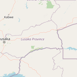
Regional context, mapped land area, and documented terrain features across Lusaka Province.
Lower Zambezi National Park Structured Geographic Profile, Boundaries, and Landscape Data
Lower Zambezi National Park encompasses 4092 square kilometers of diverse terrain within Zambia. This profile details the park geographic framework, including recorded river systems like the Zambezi, mountain peaks, and cliff formations found within its protected boundaries.
Related tags
National ParkZambezi RiverFloodplainWildlife ViewingUNESCO World Heritage Site
Remote Zambezi floodplain wilderness with exceptional wildlife viewing
Lower Zambezi National Park
Lower Zambezi National Park is a pristine wilderness area located on the north bank of the Zambezi River in southeastern Zambia. Established as a national park in 1983, the area had previously served as the private game reserve of Zambia's president, which protected it from mass tourism and helped preserve its untouched character. The park covers approximately 4,092 square kilometers and sits opposite Zimbabwe's Mana Pools National Park, with both protected areas spanning the Zambezi floodplain ringed by mountainous terrain. This region is recognized as a UNESCO World Heritage Site, representing one of the few remaining undeveloped wilderness areas in Africa.
- Location
- Zambia
- Park type
- National park
- Established
- 1983
- Area
- 4,092 km²
Location overview
Administrative boundaries and regional context in Lusaka Province
Lower Zambezi National Park Geographic Placement in Zambia
Lower Zambezi National Park is positioned within Lusaka Province in the southern African nation of Zambia. Official conservation data classifies the protected area as an entirely inland, non transboundary sanctuary.
- Countries
- Zambia
- Regions
- Lusaka Province
- Primary location
- Lusaka Province
- Geographic setting
- Inland
Boundary and coordinates
Mapped spatial outline and derived territorial measurements
Lower Zambezi National Park Boundary Map and Geographic Extent
Spatial mapping outlines the protected perimeter and provides visual context for the terrain. Recorded measurements detail the land area spanning four thousand square kilometres alongside geographic limits.
- Boundary area
- 4,100.8 km²
- Boundary perimeter
- 434.6 km
- Northernmost point
- 15.1757° S
- Southernmost point
- 15.7204° S
- Easternmost point
- 30.2051° E
- Westernmost point
- 29.1608° E
- Geographic centre
- 15.4585° S, 29.6841° E
- North–south span
- 60.3 km
- East–west span
- 112.1 km
Terrain and natural features
Mixed relief terrain classifications and recorded natural features
Lower Zambezi National Park Terrain and Natural Features
Lower Zambezi National Park features a mixed relief classification alongside recorded rivers, peaks, islands, and gorges located within the protected boundary. Linked feature cards supply names, types, measurements, and spatial relationships for each mapped natural formation.
Selected named natural features
Peaks
Chilaunga
1,490 m
Rivers
Mushika
Cliffs
Mupata Gorge
Peaks
Kaini
1,155 m
Waterfalls
Chongwe Falls
Environmental setting
Subtropical climate zones, major water presence, and mixed relief categories
Lower Zambezi National Park Environmental Classifications and Physical Settings
Recorded classifications frame the physical setting through broad landscape features, habitat types, and forest cover markers. Connected categories link directly to relevant atlas destinations across the protected region.
- Relief
- Mixed relief
- Climate
- Subtropical
- Water
- Major water bodies
- Forest cover
- Mostly forested
Landscape features
Rivers · Cliffs · Wetland · Valleys · Mountains · Forest · Grassland
Habitat types
Savanna · Wetland · Riverine habitat
Park atlas
Compare diverse protected landscapes and regional park geography across the broader Zambezi basin.
Discover Nearby National Parks and Protected Areas Surrounding Lower Zambezi National Park
After exploring Lower Zambezi National Park, browse other national parks and protected areas in its immediate vicinity and the wider Zambezi River region. Gain essential regional context by tracing mapped landscapes, comparing diverse protected areas, and understanding their ecological connections across borders.
National parkZimbabwe
Park boundaries overlap#1 closest
Southwest

Mana Pools National Park: Zimbabwe National Park Atlas and Protected Floodplain Landscapes
Explore a World Heritage protected area with iconic baobab forests.
Mana Pools National Park presents a profound example of a preserved African wilderness, recognized globally for its ecological integrity. As a UNESCO World Heritage Site, this protected landscape along the Zambezi River in Zimbabwe is defined by its four permanent pools, vast sandbanks, and distinctive forests. The park's geography supports exceptional wildlife congregations, particularly during the dry season, offering a unique atlas-level perspective on floodplain ecosystems and conservation value.
- Area
- 2,196 km²
- IUCN
- II
- Relief
- Lowland
- Scope
- Terrestrial
National parkLusaka Province
About 84 km away#2 closest
West

Lusaka National Park: Protected Woodland Habitat and Geographic Context in Lusaka Province
Zambia's smallest national park, mapping natural terrain near the capital.
Lusaka National Park, Zambia's newest national park, offers a contained yet representative example of the woodland ecosystems found on the Lusaka plateau. This protected landscape, covering 6,715 hectares, is entirely fenced, creating a distinct conservation area within Lusaka Province. Its establishment over a former forest reserve highlights a unique approach to upgrading protected lands. Explore the park's mapped terrain and understand its significance as an accessible natural enclave amid regional development, providing a focused view of central Zambian woodland environments.
- Area
- 67.15 km²
- Established
- 2011
- IUCN
- II
- Climate
- Tropical
National parkZimbabwe
About 158 km away#3 closest
Southwest
Matusadona National Park: Zimbabwe's National Park Landscape Atlas and Geographic Context
Mapped boundaries and regional terrain for Matusadona National Park.
Matusadona National Park presents a vital component of Zimbabwe's protected land inventory. This detail page offers an atlas-centric view, highlighting the park's mapped geographic features and its distinct landscape character. It is designed to facilitate a structured understanding of Matusadona National Park as a specific protected area, providing essential context for regional geography and natural landscape exploration without delving into visitor logistics or park operations.
- Area
- 1,400 km²
- Established
- 1975
- Relief
- Mixed relief
- Climate
- Subtropical
National parkTete Province
About 185 km away#4 closest
East

Magoe National Park: A National Park in Tete Province for Geographic and Landscape Exploration
Discover the mapped boundaries and regional geography of this protected area.
Magoe National Park serves as a crucial national park within Tete Province, providing a defined space for exploring regional geography and landscape features. This entry focuses on understanding the park's protected status and its mapped territories, offering valuable context for atlas and geographic research. Examine its location and boundaries to appreciate its role as a protected natural landscape within Mozambique.
- Area
- 3,559 km²
- Established
- 2013
- Scope
- Terrestrial
- Water
- Major water bodies
National parkSouth Africa
About 193 km away#5 closest
West

Blue Lagoon National Park: National Park Atlas and Mapped Wetland Geography
Discover the protected landscape and fauna of Zambia's Kafue Flats.
Blue Lagoon National Park is a critical protected area recognized for its unique wetland and floodplain environment within South Africa's extensive Kafue Flats system. Established in 1976, this national park offers significant opportunities for atlas-driven exploration of its mapped geography and protected landscape. Visitors can learn about the park's ecological significance, its characteristic terrain of lagoons and marshes, and its importance as a sanctuary for endemic wildlife and diverse bird species, contributing valuable context to the broader regional atlas.
- Area
- 500 km²
- Established
- 1976
- IUCN
- II
- Relief
- Lowland
National parkZambia
198 km away#6 closest
Northeast
South Luangwa National Park: Zambia's National Park Geographic Atlas and Protected Landscape
Explore mapped boundaries and regional context within this Zambian protected area.
South Luangwa National Park represents a vital national park within Zambia, offering a distinct focal point for atlas-based geographic exploration. This dedicated entry details the park's mapped area and its integration into the surrounding Zambian geography. Users seeking to understand protected landscapes, regional park distributions, and natural terrain context will find South Luangwa National Park a key reference for detailed mapping and landscape analysis.
- Area
- 9,050 km²
- Established
- 1972
- IUCN
- II
- Relief
- Mixed relief
National parkZambia
200 km away#7 closest
West
Lochinvar National Park: A Mapped Zambian Floodplain Protected Landscape
Explore its unique wetland geography and protected area boundaries.
Lochinvar National Park in Zambia is a vital protected landscape characterized by extensive floodplains and seasonal wetlands along the Kafue River. As a national park, it safeguards the unique ecosystem of the Kafue Flats, renowned for hosting massive herds of endemic Kafue lechwe and a remarkable diversity of bird species, exceeding 400 recorded. The park's terrain varies from open marshes and lagoons like Chunga Lagoon to drier woodlands dotted with termite mounds and low hills, providing a geographically rich environment for detailed atlas exploration and landscape context.
- Area
- 428 km²
- Established
- 1972
- IUCN
- II
- Relief
- Lowland
National parkZimbabwe
About 257 km away#8 closest
Southwest
Chizarira National Park: Zimbabwe's Remote Protected Landscape on the Zambezi Escarpment
Explore rugged mountains, deep gorges, and unique woodland ecosystems.
Chizarira National Park offers an unparalleled exploration of wilderness and dramatic geography within Zimbabwe. Situated along the imposing Zambezi Escarpment, its landscape is characterized by a 600-meter drop, rugged mountains, and deep river gorges carved by perennial streams. This protected area, known for its remote appeal and rich leopard populations, provides a distinct view of miombo and mopane woodlands, contributing to its unique ecological identity within the regional geography.
- Area
- 2,000 km²
- Established
- 1975
- IUCN
- II
- Relief
- Mountain
MoriAtlas Explorer
Continue exploring the mapped geography of Lower Zambezi National Park
Delve deeper into the structured geographic data for Lower Zambezi National Park, understanding its unique landscape and protected area context. This exploration is key to appreciating its role within Lusaka Province and gaining a clearer atlas perspective on Zambia's natural landscapes. Continue your discovery of this national park and its surrounding regional geography for a comprehensive understanding.
Browse next
Global natural geography
Explore related park routes
Explore MoriAtlas Global ParksBrowse All MoriAtlas ParksGlobal Park Map DiscoveryMoriAtlas: Browse All CountriesBrowse All MoriAtlas ContinentsNational Park Environment AtlasGrand Canyon National Park AtlasYellowstone National Park AtlasYosemite National Park Atlas and GeographySerengeti National Park AtlasGalápagos National Park Protected LandscapeBanff National Park Geography and AtlasKruger National Park Atlas EntryUluṟu-Kata Tjuṯa National Park AtlasExplore Uluru-Kata Tjuta National Park GeographyPlitvice Lakes National Park AtlasFiordland National Park Protected LandscapeGreat Smoky Mountains National Park AtlasAfghanistan National Parks and Protected AreasAlbania National Parks and Protected AreasAlgeria National Parks and Protected AreasAmerican Samoa National Parks and Protected AreasAndorra National Parks and Protected AreasAngola National Parks and Protected AreasAntarctica National Parks and Protected AreasAntigua and Barbuda Park List