

Mori Atlas logo
National parkLusaka National Park

Zambia's newest and smallest national park, mapping its unique protected habitat near the capital.

Lusaka National Park: Protected Woodland Landscape and Atlas Exploration in Lusaka Province

Lusaka National Park represents Zambia's most recent addition to its protected areas network, established as the country's smallest national park. Situated in Lusaka Province, this park preserves a vital pocket of woodland and forest ecosystems characteristic of the central Zambian plateau. Its creation from a former forest reserve highlights successful land transformation for conservation, offering a unique case study in urban-proximate wilderness management. The entirely fenced boundaries define a distinct protected landscape, providing an accessible natural retreat for exploring the region's mapped geography and habitat.

National ParkWoodland HabitatZambiaSouthern AfricaUrban Proximate ConservationSmall Parks

Lusaka National Park

National park

Park overview

Structured park overview, official facts, and landscape profile for Lusaka National Park

Lusaka National Park park facts, protected area profile, and essential visitor context

Review the core facts for Lusaka National Park, including designation, size, terrain, visitor scale, habitats, and operating context in one park-focused overview.

About Lusaka National Park

Lusaka National Park represents an important addition to Zambia's conservation estate despite its modest size. Located in the southern portion of Lusaka Province within Kafue District, the park occupies a strategic position near Zambia's largest city and administrative center. The transformation of the former Lusaka South Local Forest into a national park in 2011 reflected Zambia's commitment to expanding its protected area network and improving conservation protection for areas with significant ecological value. The park's entire perimeter is enclosed by fencing, a management approach that distinguishes it from many other Zambian protected areas and helps regulate human-wildlife interactions in this densely populated region. The park's location adjacent to the Lusaka South Multi-Facility Economic Zone highlights the balancing act between development and conservation that characterizes modern land-use planning in rapidly urbanizing areas of southern Africa. Despite its small size relative to Zambia's other national parks, the area provides important habitat for various wildlife species and contributes to the country's biodiversity conservation efforts.

Quick facts and research context for Lusaka National Park

Lusaka National Park spans 6,715 hectares in Kafue District, making it the smallest of Zambia's national parks. The park was established in 2011 and officially opened in 2015, representing the most recent addition to Zambia's protected area network. Located approximately 30 kilometers south-east of Lusaka city center, the park occupies former forest reserve land that was historically part of the Lusaka South Local Forest. The area is entirely fenced, distinguishing it from many other Zambian protected areas that remain open to surrounding landscapes. The park is managed by the Zambia Wildlife Authority.

Protection and recognition

Mapping the terrestrial boundaries, 2011 designation timeline, and regional conservation profile

Lusaka National Park Official Protection Status and Protected Area Designation

Verifying the documented terrestrial protection status and 2011 designation parameters establishes the formal conservation footprint of Lusaka National Park. Tracking certified geographic records provides researchers with clear insights into regional management scopes and official environmental boundaries within Zambia.

Protection details

Protection scope
Terrestrial
Designated year
2011
Transboundary protection
No
Park context

Deeper park guide and search-rich context for Lusaka National Park

Lusaka National Park history, landscape, wildlife, and travel context

Explore Lusaka National Park through its history, landscape character, ecosystems, wildlife, conservation priorities, cultural context, and seasonal travel timing in a structured park guide built for atlas discovery and search intent.

Why Lusaka National Park stands out

Lusaka National Park is best known for its distinction as Zambia's smallest and newest national park, offering accessible wilderness near the capital city. The park provides a compact but representative example of the woodland and forest ecosystems characteristic of the Lusaka plateau region. Its proximity to Lusaka makes it particularly significant as an accessible natural area for residents of the capital seeking nearby wildlife experiences and outdoor recreation opportunities. The park's establishment over former forest reserve land also represents a successful model of upgrading existing protected forest areas to full national park status.

Lusaka National Park history and protected-area timeline

Lusaka National Park was formally established in 2011, making it the most recently created national park in Zambia. Prior to its designation as a national park, the area existed as the Lusaka South Local Forest, a forest reserve that had long been recognized for its ecological and watershed values. The conversion of the forest reserve to national park status represented an upgrading of protective status, reflecting the government's recognition of the area's importance for biodiversity conservation. Before 2010, the land that now encompasses both the national park and the adjacent Lusaka South Multi-Facility Economic Zone was collectively known as the Lusaka South Local Forest, indicating the historical unity of the landscape before industrial development split the area. The park was officially opened to the public in 2015, completing the transition from protected forest to fully operational national park. This relatively recent establishment means the park is still developing its visitor infrastructure and management programs.

Lusaka National Park landscape and geographic character

Lusaka National Park occupies a landscape characterized by woodland and forest vegetation typical of the central Zambian plateau. The terrain consists of gently undulating terrain typical of the region, with soils supporting mixed woodland ecosystems. The park's location in Kafue District places it within a broader landscape that has experienced various land-use pressures from agricultural expansion and urban development associated with Lusaka's growth. The entirely fenced boundary creates a distinct protected enclave within this dynamic landscape, preserving a pocket of natural habitat amid surrounding development. The park's compact size means visitors can traverse significant portions of the terrain, though the landscape maintains the characteristic appearance of mature woodland that distinguishes this part of Lusaka Province.

Lusaka National Park ecosystems, habitats, and plant life

The park protects woodland and forest habitats representative of the central Zambian ecological zone. As a former forest reserve, the area retained significant tree cover and ecological integrity that supported its elevation to national park status. The woodland ecosystems within the park provide habitat for various plant species characteristic of the region, and the protected status ensures the preservation of these communities amid surrounding land-use changes. The fenced boundary helps maintain ecological integrity by reducing human disturbance and providing a more controlled environment for wildlife. While specific ecological details are limited in available sources, the park's foundation on former forest reserve land indicates the presence of meaningful biodiversity values that justified the upgrade in protection status.

Lusaka National Park wildlife and species highlights

While specific wildlife inventories are not detailed in available sources, Lusaka National Park provides protected habitat for wildlife species adapted to woodland environments in central Zambia. The park's location near Lusaka and its status as a fenced protected area create conditions that support populations of various mammal, bird, and reptile species common to the region. The woodland and forest habitats within the park offer foraging and shelter opportunities for wildlife, while the fenced boundary provides some protection from human encroachment and poaching pressure that affects more accessible areas. As Zambia's smallest national park, the wildlife populations are necessarily limited in scale compared to larger protected areas, but the park still contributes to regional biodiversity conservation.

Lusaka National Park conservation status and protection priorities

Lusaka National Park contributes to Zambia's national conservation strategy by providing protected status to a representative area of central Zambian woodland. The park's establishment over former forest reserve land demonstrates a model of conservation enhancement, upgrading existing protective designations to more robust national park status. Its small size and fenced nature create a manageable conservation unit that can be effectively patrolled and protected. The park's proximity to Lusaka also provides important ecosystem services for the capital region, including watershed protection and environmental buffering. As Zambia's newest national park, it represents ongoing investment in expanding the country's protected area network to cover representative examples of all major ecological zones.

Lusaka National Park cultural meaning and human context

Lusaka National Park occupies land with historical connections to the broader Lusaka region, which has experienced significant development and population growth since Zambia's independence. The area's previous designation as part of the Lusaka South Local Forest reflects its long-standing recognition as having environmental values warranting protection. The park's location adjacent to the Lusaka South Multi-Facility Economic Zone illustrates the modern dynamic between conservation and development that characterizes much of Zambia's peri-urban landscape. The park provides an accessible natural area for residents of Lusaka, offering opportunities for environmental education and outdoor recreation that support cultural connections to nature.

Top sights and standout views in Lusaka National Park

The park's standout features include its status as Zambia's smallest and newest national park, its accessible location near the capital city, and its representation of woodland ecosystems on the Lusaka plateau. The entirely fenced perimeter creates a distinct protected environment that distinguishes this park from Zambia's larger, more open conservation areas. Visitors can experience representative central Zambian woodland environments within a manageable area that allows for thorough exploration. The park serves as an important gateway for residents of Lusaka to access protected nature without traveling to more distant parks in Zambia's extensive conservation estate.

Best time to visit Lusaka National Park

The optimal time to visit Lusaka National Park falls during the dry season from May to October, when wildlife viewing conditions are most favorable and vegetation is less dense. The dry winter months offer comfortable temperatures and improved visibility for spotting wildlife as animals concentrate around water sources. The wet season from November to April brings lush green landscapes but can make some areas less accessible and wildlife more dispersed. The park's small size means it can be explored relatively quickly compared to Zambia's vast national parks, allowing visitors to experience the protected area in a single day trip from Lusaka.

Monthly climate preview

Analyzing historical temperature cycles and monthly precipitation averages in Lusaka Province

Lusaka National Park Climate Profile and Monthly Weather Averages

Long-term meteorological data in the high-elevation terrain of Lusaka Province indicates a pronounced wet period peaking around January alongside a distinct dry cycle during the cooler middle months. Accessing the complete monthly climatology dataset reveals detailed daily temperature extremes and average rainfall distributions across all twelve months.
Annual mean22 °C
17 °C26 °C
Jan22°
Feb22°
Mar22°
Apr21°
May20°
Jun18°
Jul17°
Aug20°
Sep24°
Oct26°
Nov26°
Dec23°
Warmest month
October

26.5 °C

Coolest month
July

17.2 °C

Wettest month
January

6.5 mm/day

Driest month
July

0 mm/day

Park location guide

Geography guide, regional context, and park location map for Lusaka National Park

Lusaka National Park park geography, regions, and map view in Zambia

Understand where Lusaka National Park sits in Zambia through a broader geographic reading of the surrounding landscape, nearby location context, and its mapped position within the national park landscape.

How Lusaka National Park fits into Zambia

Zambia is a landlocked nation in Southern Africa with a population of approximately 20 million people. The country is bordered by eight countries and features diverse geography ranging from the Zambezi River to vast plateaus. Lusaka serves as the capital and largest city, while the Copperbelt Province in the north drives much of the economy through copper mining.

Wider geography shaping Lusaka National Park in Zambia

Zambia is located in Southern Africa and is landlocked, bordered by eight countries: Democratic Republic of the Congo to the north, Tanzania to the northeast, Malawi to the east, Mozambique to the southeast, Zimbabwe and Botswana to the south, Namibia to the southwest, and Angola to the west. The country features varied terrain including the Zambezi River plain in the south, plateaus in the central and northern regions, and the Muchinga Mountains in the northeast. Lake Tanganyika forms part of the northern border.

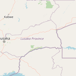
Map view of Lusaka National Park

Use this park location map to pinpoint Lusaka National Park in Zambia, understand its exact geographic position, and read its mapped placement within the surrounding landscape more clearly.

Pigeon | © OpenStreetMap contributors

Location context for Lusaka National Park

Kafue DistrictLusaka Province
Park atlas

Trace surrounding protected landscapes and compare other significant conservation areas across Zambia's central plateau.

Explore Nearby National Parks and Protected Areas Beyond Lusaka National Park

Browse a curated selection of national parks and protected areas near Lusaka National Park, extending geographic exploration into Zambia's diverse conservation landscapes. Compare these protected areas by mapped terrain and ecological features to understand the broader regional context of conservation across Zambia.
National parkLusaka Province
About 84 km away#1 closest

East

Lower Zambezi National Park: Mapped Protected Area and Regional Geography

Lusaka Province National Park Landscape Context

Lower Zambezi National Park represents a key protected landscape within Zambia, specifically situated in Lusaka Province. This park's detail page focuses on its role as a national park, offering insights into its geographic contours, mapped park boundaries, and its overall context within the regional geography. Engage with structured data to understand the natural landscape characteristics and the atlas-relevant distribution of this protected area.

Area
4,092 km²
Established
1983
IUCN
II
Relief
Mixed relief
National parkZimbabwe
About 88 km away#2 closest

East

Mana Pools National Park: Zimbabwe National Park Atlas and Protected Floodplain Landscapes

Explore a World Heritage protected area with iconic baobab forests.

Mana Pools National Park presents a profound example of a preserved African wilderness, recognized globally for its ecological integrity. As a UNESCO World Heritage Site, this protected landscape along the Zambezi River in Zimbabwe is defined by its four permanent pools, vast sandbanks, and distinctive forests. The park's geography supports exceptional wildlife congregations, particularly during the dry season, offering a unique atlas-level perspective on floodplain ecosystems and conservation value.

Area
2,196 km²
IUCN
II
Relief
Lowland
Scope
Terrestrial
National parkSouth Africa
About 109 km away#3 closest

West

Blue Lagoon National Park: National Park Atlas and Mapped Wetland Geography

Discover the protected landscape and fauna of Zambia's Kafue Flats.

Blue Lagoon National Park is a critical protected area recognized for its unique wetland and floodplain environment within South Africa's extensive Kafue Flats system. Established in 1976, this national park offers significant opportunities for atlas-driven exploration of its mapped geography and protected landscape. Visitors can learn about the park's ecological significance, its characteristic terrain of lagoons and marshes, and its importance as a sanctuary for endemic wildlife and diverse bird species, contributing valuable context to the broader regional atlas.

Area
500 km²
Established
1976
IUCN
II
Relief
Lowland
National parkZambia
About 119 km away#4 closest

West

Lochinvar National Park: A Mapped Zambian Floodplain Protected Landscape

Explore its unique wetland geography and protected area boundaries.

Lochinvar National Park in Zambia is a vital protected landscape characterized by extensive floodplains and seasonal wetlands along the Kafue River. As a national park, it safeguards the unique ecosystem of the Kafue Flats, renowned for hosting massive herds of endemic Kafue lechwe and a remarkable diversity of bird species, exceeding 400 recorded. The park's terrain varies from open marshes and lagoons like Chunga Lagoon to drier woodlands dotted with termite mounds and low hills, providing a geographically rich environment for detailed atlas exploration and landscape context.

Area
428 km²
Established
1972
IUCN
II
Relief
Lowland
National parkZimbabwe
About 162 km away#5 closest

South

Matusadona National Park: Zimbabwe's National Park Landscape Atlas and Geographic Context

Mapped boundaries and regional terrain for Matusadona National Park.

Matusadona National Park presents a vital component of Zimbabwe's protected land inventory. This detail page offers an atlas-centric view, highlighting the park's mapped geographic features and its distinct landscape character. It is designed to facilitate a structured understanding of Matusadona National Park as a specific protected area, providing essential context for regional geography and natural landscape exploration without delving into visitor logistics or park operations.

Area
1,400 km²
Established
1975
Relief
Mixed relief
Climate
Subtropical
National parkZambia
About 183 km away#6 closest

West

Kafue National Park: Zambia's Key National Park for Geographic and Protected Area Exploration

Mapped boundaries and landscape context in southern Africa.

Kafue National Park represents a vital component of Zambia's protected lands, offering a distinct perspective for atlas-driven geographic exploration. This national park's identity is tied to its extensive mapped boundaries and its contribution to the regional landscape of southern Africa. Users engaging with this entry can uncover the protected area's specific geographic context and map-based details, enhancing their understanding of conservation landscapes.

Area
22,400 km²
IUCN
II
Relief
Lowland
Climate
Tropical
National parkZimbabwe
About 250 km away#7 closest

South

Chizarira National Park: Zimbabwe's Remote Protected Landscape on the Zambezi Escarpment

Explore rugged mountains, deep gorges, and unique woodland ecosystems.

Chizarira National Park offers an unparalleled exploration of wilderness and dramatic geography within Zimbabwe. Situated along the imposing Zambezi Escarpment, its landscape is characterized by a 600-meter drop, rugged mountains, and deep river gorges carved by perennial streams. This protected area, known for its remote appeal and rich leopard populations, provides a distinct view of miombo and mopane woodlands, contributing to its unique ecological identity within the regional geography.

Area
2,000 km²
Established
1975
IUCN
II
Relief
Mountain
National parkZambia
About 344 km away#8 closest

Northeast

South Luangwa National Park: Zambia's National Park Geographic Atlas and Protected Landscape

Explore mapped boundaries and regional context within this Zambian protected area.

South Luangwa National Park represents a vital national park within Zambia, offering a distinct focal point for atlas-based geographic exploration. This dedicated entry details the park's mapped area and its integration into the surrounding Zambian geography. Users seeking to understand protected landscapes, regional park distributions, and natural terrain context will find South Luangwa National Park a key reference for detailed mapping and landscape analysis.

Area
9,050 km²
Established
1972
IUCN
II
Relief
Mixed relief

Common questions about visiting, size, designation, and location context for Lusaka National Park

Lusaka National Park FAQs for park facts, access, geography, and protected area context

Find quick answers about Lusaka National Park, including protected-area facts, park geography, trail and visitor context, and how the park fits into its surrounding country and regional landscape.
MoriAtlas Explorer

Continue Your Protected Areas Search Across the Global Atlas

Deepen your exploration by continuing the structured search for national parks and protected areas worldwide. Utilize the comprehensive filtering capabilities to compare different conservation landscapes and refine your understanding of global park geography. Discover more about the distribution and characteristics of protected natural areas.

Global natural geography
