

Mori Atlas logo
Nature reserveMacquarie Marshes Nature Reserve

A critical inland wetland complex within the lower Macquarie River floodplain of New South Wales

Macquarie Marshes Nature Reserve: Exploring the Geography and Protected Landscape Boundaries

Macquarie Marshes Nature Reserve serves as a vital protected landscape in northwestern New South Wales, encompassing a representative mosaic of river red gum forests, reedbeds, and seasonal floodplains. As a core segment of an internationally recognized wetland complex, the reserve illustrates the complex interplay between river hydrological cycles and native vegetation. This mapping provides a deeper look at the ecological significance and physical terrain defining this critical Australian habitat.

wetlandfloodplainRamsar siteriver red gum forestreedbedwaterbirds

Macquarie Marshes Nature Reserve

Nature reserve

Park overview

Structured park overview, official facts, and landscape profile for Macquarie Marshes Nature Reserve

Macquarie Marshes Nature Reserve park facts, protected area profile, and essential visitor context

Review the core facts for Macquarie Marshes Nature Reserve, including designation, size, terrain, visitor scale, habitats, and operating context in one park-focused overview.

About Macquarie Marshes Nature Reserve

Macquarie Marshes Nature Reserve sits within a vast flat floodplain that has been shaped over millennia by irregular flooding of the Macquarie River. The reserve itself consists of two principal sections, the North Marsh and South Marsh, together with a third smaller reserve. Across this footprint, the wetlands capture one of the most complete cross-sections of habitat types found within the broader Macquarie Marshes, ranging from open water and reedbeds to river red gum woodland and drier fringing vegetation.

The reserve is more than a stand-alone conservation area: it functions as the ecological heartbeat of a very large wetland mosaic. While the nature reserve protects the most frequently flooded portion of the floodplain, extensive wetlands of regional and national importance lie outside its boundaries, including large river red gum forests and some of the most significant breeding colonies in the entire Marshes. This makes the reserve both a refuge in its own right and a vital anchor for biodiversity across the wider landscape.

Its identity is closely bound up with water. The structure and species composition of vegetation here are governed primarily by how often, how deeply, and for how long flooding occurs. Periodic inundation drives pulses of productivity that ultimately support large populations of waterbirds and other wildlife. This reliance on a natural flooding regime also makes the reserve highly sensitive to changes in the catchment: the timing, volume, and frequency of flows reaching the Marshes directly shape the condition of the reserve and the populations it supports.

At a broader scale, Macquarie Marshes Nature Reserve is significant because it preserves a striking example of a working floodplain where pastoral and cropping land coexist with internationally important wetland habitat. The contrast between the protected reserve and the surrounding agricultural matrix is part of what gives the area its conservation profile, and also part of what makes its long-term management so important, as upstream water use, land management practices, and floodplain health all interact to determine what the Marshes will look like in the decades ahead.

Quick facts and research context for Macquarie Marshes Nature Reserve

Macquarie Marshes Nature Reserve is a state-level strict nature reserve in northwestern New South Wales, located along the lower Macquarie River roughly 100 kilometres north of Warren and around 600 kilometres northwest of Sydney. The reserve covers approximately 19,800 hectares and represents about 10 percent of the broader Macquarie Marshes floodplain. Together its North and South Marsh components were listed as a Ramsar Wetland of International Importance in August 1986. The site also appears on multiple national wetland inventories and is recognized by BirdLife International as an Important Bird Area for breeding waterbirds.

Protection and recognition

Explore the documented terrestrial conservation scope and official designation timeline

Macquarie Marshes Nature Reserve Protection Status and Designation History

Macquarie Marshes Nature Reserve maintains a documented terrestrial protection status established in nineteen eighty six. Designated records outline the official conservation scope and administrative history without additional international recognition sources.

Protection details

Protection scope
Terrestrial
Designated year
1986
Transboundary protection
No
Park context

Deeper park guide and search-rich context for Macquarie Marshes Nature Reserve

Macquarie Marshes Nature Reserve history, landscape, wildlife, and travel context

Explore Macquarie Marshes Nature Reserve through its history, landscape character, ecosystems, wildlife, conservation priorities, cultural context, and seasonal travel timing in a structured park guide built for atlas discovery and search intent.

Why Macquarie Marshes Nature Reserve stands out

Macquarie Marshes Nature Reserve is best known as one of Australia's most significant inland wetland complexes, particularly for its role as a breeding ground for colonial waterbirds and its mix of river red gum forest, reedbeds, and periodically flooded woodland. It stands out as a Ramsar-listed refuge within an otherwise heavily modified agricultural floodplain, where the interplay between natural flooding cycles and moisture-dependent vegetation creates habitat for a wide spectrum of bird, mammal, reptile, amphibian, and fish species.
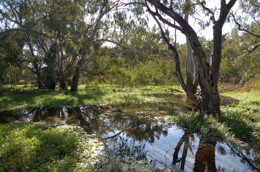
A landscape view of a flooded wetland area surrounded by large, spreading eucalyptus trees with sun-dappled foliage and reflections in the water.
A view of the wetland ecosystem within the Macquarie Marshes Nature Reserve.

Macquarie Marshes Nature Reserve history and protected-area timeline

Macquarie Marshes Nature Reserve was formally established in January 1971 as a state-level protected area in New South Wales, recognizing the outstanding wetland values of the section of the Macquarie Marshes floodplain that is most frequently inundated. In August 1986, the North and South Marsh components of the reserve were inscribed as a Ramsar Wetland of International Importance under the Ramsar Convention of 1971, formalizing the site's status on the global stage.

The reserve has since been incorporated into multiple national recognition frameworks, including listings on the Register of the National Estate, the National Trust of Australia register, and the Directory of Important Wetlands in Australia. BirdLife International subsequently identified the Macquarie Marshes as an Important Bird Area, highlighting its significance for breeding waterbirds. An environmental trust has also been established to build wider community support for the ongoing protection of the wetlands, reflecting growing concern about the long-term pressures facing the floodplain.

Macquarie Marshes Nature Reserve landscape and geographic character

The reserve occupies an essentially flat section of the lower Macquarie floodplain, where topography interacts with seasonal and irregular river flooding to create a shifting mosaic of wetlands, reedbeds, and woodlands. The most distinctive landscape features are the dense river red gum forests, which dominate the higher and more frequently flooded ground, and the extensive beds of common reed that occupy the wettest, most persistently inundated depressions.

Beyond the reserve boundary, the broader Macquarie Marshes extend across tens of thousands of hectares, but the nature reserve captures the most hydrologically active slice of that floodplain. Where water lies shallow and stands longest, open reedbed and marsh vegetation take over; where flooding is periodic rather than prolonged, river red gum woodland thrives. This gradient, from permanent and semi-permanent wetlands to seasonally flooded forest, gives the reserve its characteristic layered landscape and underpins much of its ecological value.

Macquarie Marshes Nature Reserve ecosystems, habitats, and plant life

Ecologically, Macquarie Marshes Nature Reserve is defined by the relationship between flooding and vegetation. Plant communities are arranged largely along a moisture gradient, with river red gum forest and woodland occupying the better-drained parts of the floodplain and extensive common reed beds dominating the lowest, wettest ground. A range of intermediate vegetation associations, including patches of black box and other flood-dependent eucalypts, fill in the transition zones, producing a structurally diverse habitat mosaic across a relatively flat landscape.

This range of habitats, compressed into a single reserve, sustains an unusually high concentration of wildlife for an inland site. The diversity of aquatic, semi-aquatic, and terrestrial environments produced by the flooding cycle supports many of the species groups characteristic of Murray-Darling floodplain systems and gives the reserve a particular importance for waterbirds that depend on seasonal flooding for breeding.

Macquarie Marshes Nature Reserve wildlife and species highlights

The reserve supports a notably rich fauna for an inland wetland site. BirdLife records cited in connection with the Marshes reference the presence of more than 200 bird species, along with native mammals, frogs, reptiles, and fish, reflecting the diverse habitat structure of the floodplain. The wetlands are widely recognized as one of the most important breeding sites in Australia for the intermediate egret and straw-necked ibis, both of which form large seasonal colonies when conditions are favorable.

A number of bird species recorded here are listed as vulnerable or threatened, including the magpie goose, blue-billed duck, freckled duck, Australasian bittern, brolga, painted snipe, osprey, glossy black cockatoo, turquoise parrot, square-tailed kite, and Major Mitchell's cockatoo. This combination of large breeding aggregations of common waterbirds and a roster of threatened species underscores the reserve's significance for waterbird conservation in southeastern Australia.

Macquarie Marshes Nature Reserve conservation status and protection priorities

Macquarie Marshes Nature Reserve sits at the intersection of international wetland conservation recognition and ongoing regional land use pressures. Its Ramsar listing, register listings, and Important Bird Area status place it among the better-known and more formally recognized wetland sites in the Murray-Darling Basin, while its position within an extensively modified agricultural landscape makes its long-term condition closely dependent on water management upstream.

The principal long-term conservation concern is that the flooding regime which maintains the wetlands is increasingly affected by water extraction along the Macquarie River for irrigation. Reduced frequency or volume of flooding can degrade river red gum health, reduce reedbed extent, and diminish breeding habitat for waterbirds. The establishment of an environmental trust to support the Marshes reflects an effort to complement formal reserve protection with broader community and institutional engagement, acknowledging that the reserve's ecological future is tied to how the wider catchment is managed.

Top sights and standout views in Macquarie Marshes Nature Reserve

The reserve's strongest points of distinction lie in its combination of internationally recognized wetland status, its role as a breeding ground for Australian waterbirds, and its ecological relationship with an extensive agricultural floodplain. Its river red gum forests, common reed beds, and the diversity of flooding-dependent vegetation associations form the structural backbone of these values, while the concentration of threatened and colonial-nesting bird species gives the site its particular conservation profile.

Best time to visit Macquarie Marshes Nature Reserve

The character of Macquarie Marshes Nature Reserve is closely tied to the timing and extent of flooding on the Macquarie River, so the experience of visiting varies considerably with seasonal conditions. After significant flood events, the reserve is at its most dynamic, with extensive inundated ground, active reedbeds, and large numbers of waterbirds taking advantage of the fresh conditions for breeding; in drier periods, the landscape shifts toward more open woodland and shrunken wetland areas, with different bird communities and a more subdued atmosphere. As with any inland wetland site, planning around regional water conditions and seasonal flooding patterns, rather than a fixed calendar window, is likely to yield the richest experience.
Monthly climate preview

Long-term temperature ranges and monthly precipitation data for New South Wales

Macquarie Marshes Nature Reserve Climate Normals and Annual Weather Patterns

Historical climatology records outline the measured annual temperature rhythm and monthly precipitation variations across representative coordinates in Macquarie Marshes Nature Reserve. Examining the full twelve-month profile provides detailed meteorological context for studying long-term environmental conditions across the protected area.
Annual mean20 °C
10 °C29 °C
Jan29°
Feb28°
Mar25°
Apr20°
May15°
Jun11°
Jul10°
Aug12°
Sep17°
Oct21°
Nov24°
Dec27°
Warmest month
January

29.3 °C

Coolest month
July

10.4 °C

Wettest month
January

1.7 mm/day

Driest month
August

0.7 mm/day

Park location guide

Geography guide, regional context, and park location map for Macquarie Marshes Nature Reserve

Macquarie Marshes Nature Reserve park geography, regions, and map view in Australia

Understand where Macquarie Marshes Nature Reserve sits in Australia through a broader geographic reading of the surrounding landscape, nearby location context, and its mapped position within the national park landscape.

How Macquarie Marshes Nature Reserve fits into Australia

Australia is a constitutional monarchy and federal parliamentary democracy comprising six states and ten territories. With a population of nearly 28 million, it is one of the world's most urbanised countries, with most people concentrated on the eastern seaboard. The country has a high Human Development Index and is known for its cultural diversity, ancient Aboriginal heritage, and unique wildlife.

Wider geography shaping Macquarie Marshes Nature Reserve in Australia

Australia occupies the entire Australian continent, the island of Tasmania, and numerous smaller islands. It is the world's flattest and driest inhabited continent, featuring vast deserts in the interior (the Outback), tropical rainforests along the eastern coast, and a coastline bordering the Indian and Pacific Oceans.

Map view of Macquarie Marshes Nature Reserve

Use this park location map to pinpoint Macquarie Marshes Nature Reserve in Australia, understand its exact geographic position, and read its mapped placement within the surrounding landscape more clearly.

Pigeon | © OpenStreetMap contributors

Location context for Macquarie Marshes Nature Reserve

New South Wales
Recorded earthquake history

Explore Recorded Seismic Activity Near Macquarie Marshes Nature Reserve

Review the historical record of earthquakes documented within the proximity of Macquarie Marshes Nature Reserve. This MoriAtlas catalogue provides structured data on seismic events to support your geographic understanding of the surrounding New South Wales floodplain landscape.

Macquarie Marshes Nature Reserve Earthquake History

Catalogued events

1 event

Strongest magnitude

Magnitude 4.8

Most recent event

May 23, 2025

This history includes earthquakes recorded inside the park or within 50 km of its borders

Explore photographic records of wetland habitats, river red gum forests, and floodplain terrain.

Macquarie Marshes Nature Reserve Photos and Visual Landscape Scenery

Visual records illustrate the flat floodplain terrain, dense river red gum forests, and extensive reedbeds that define the reserve. Examining these photographic views helps researchers understand wetland habitats and seasonal inundation patterns across the protected ecosystem.

A landscape view of a flooded wetland area surrounded by large, spreading eucalyptus trees with sun-dappled foliage and reflections in the water.

A horizontal, dark brown entrance sign for Macquarie Marshes Nature Reserve standing in a wide, dry, sandy expanse under a clear blue sky.

Park atlas

Compare surrounding floodplain reserves, wetland habitats, and protected landscapes.

Parks Near Macquarie Marshes Nature Reserve and Regional Protected Areas

Browse other protected areas and regional wetland reserves situated across the surrounding inland basin. Comparing these adjacent conservation landscapes helps contextualize local flooding dynamics and regional biodiversity patterns.
National parkOrana
125 km away#1 closest

Southeast

Warrumbungle National Park: Detailed National Park Protected Landscape Atlas Entry

Mapped geography and protected boundaries within Orana, Australia.

Warrumbungle National Park is an Australian national park that serves as a prime example of a protected landscape for atlas-based geographic exploration. This entry provides detailed context on its mapped boundaries and regional terrain, anchoring it within the Orana area. Users can engage with its specific geographic identity, understanding its role as a distinct natural area within Australia's broader conservation atlas and mapped park network.

Area
233.11 km²
Established
1953
IUCN
II
Visitors
35K annual
National parkNew South Wales
154 km away#2 closest

West

Gundabooka National Park: Australian Protected Landscape Geography

Mapped boundaries and regional context within New South Wales.

Gundabooka National Park serves as a vital national park entity within the Australian protected areas system. This entry focuses on its specific geographic footprint and landscape character, offering a foundation for understanding its role and distribution within New South Wales. Explore the mapped context and regional geography that define Gundabooka National Park as a protected natural landscape.

Area
639.02 km²
Established
1996
IUCN
II
Relief
Mountain
National parkAustralia
162 km away#3 closest

North

Culgoa National Park: Iconic Coolabah Woodlands and River Floodplain Landscapes of Australia

Explore mapped boundaries and regional geography in this New South Wales protected area.

Culgoa National Park is a premier example of a preserved semi-arid outback landscape in Australia, celebrated for its extensive and intact coolabah woodlands. This national park protects vital river floodplains and a chain of permanent waterholes along the Culgoa River, contributing significantly to the biodiversity of the Darling River catchment. Understanding its geographic setting and the mapped distribution of its unique vegetation communities offers deep insight into Australia's natural heritage.

Area
352.39 km²
Established
1996
IUCN
II
Relief
Lowland
National parkNew South Wales
184 km away#4 closest

East

Garrawilla National Park: New South Wales Protected Woodland Ecosystems & Regional Geography

Explore mapped boundaries and native vegetation in this inland Australian national park.

Garrawilla National Park represents a significant protected landscape in New South Wales, Australia, dedicated to conserving semi-arid woodland terrain and characteristic native grass communities. Established to safeguard these vital ecosystems, the park offers insights into the natural heritage of the Central West region's geography. Users can explore its specific geographic footprint and understand its contribution to the preservation of inland Australian vegetation, providing a clear picture of its protected area identity.

Area
9.37 km²
Established
2005
IUCN
II
Scope
Terrestrial
National parkNew South Wales
187 km away#5 closest

West

Toorale National Park: Inland Floodplain and Wetland Protected Area in New South Wales

Discover its unique geography at the Darling and Warrego River confluence.

Toorale National Park is a critical protected area in the arid interior of New South Wales, Australia, recognized for its expansive inland floodplain and a significant wetland system formed by historic water management. Situated at the convergence of the Darling and Warrego Rivers, the park's terrain is predominantly flat, characterized by riparian floodplains and occasional low ridges. This landscape supports diverse vegetation communities, including river red gum forests and extensive chenopod shrublands, offering a unique insight into inland Australian geography and conservation values. Explore the mapped boundaries and natural context of this important national park.

Area
308.66 km²
Established
2010
IUCN
II
Relief
Lowland
National parkNew South Wales
191 km away#6 closest

South

Goobang National Park: Detailed Geographic and Protected Landscape Exploration

Mapped Boundaries and Natural Terrain in New South Wales

Discover the specific geographic features and protected boundaries of Goobang National Park. This entry offers an atlas-focused perspective, highlighting its role as a national park within New South Wales and providing foundational data for understanding its natural landscape and regional setting. Dive into a structured exploration of its mapped terrain and protected status.

Area
421 km²
Established
1995
IUCN
II
Relief
Upland
State or regional parkNew South Wales
196 km away#7 closest

West

Toorale State Conservation Area: A Landmark Protected Landscape in the Western New South Wales Outback

Floodplain ecosystems and joint-managed riverine wilderness.

Toorale State Conservation Area stands as a major protected region in New South Wales, anchoring critical habitat along the Darling-Baaka River system. This vast, former pastoral landscape features extensive floodplains, arid outback terrain, and elevated lookouts that reveal the scale of the Murray-Darling Basin. As a cooperative conservation area, the land reflects both deep indigenous heritage and focused ecological restoration in a sparsely settled, semi-arid environment.

Area
543.85 km²
Established
2010
Relief
Lowland
Climate
Arid
National parkQueensland
About 209 km away#8 closest

Northwest

Culgoa Floodplain National Park: Queensland National Park and Protected Landscape Identity

Explore mapped boundaries and regional geographic context.

Culgoa Floodplain National Park is a designated national park located in Queensland, Australia. This page details its identity as a protected landscape, emphasizing its geographical placement within the northeastern Australian region. Users can discover the park's mapped boundaries, understand its role within Queensland's geography, and engage with atlas-style exploration tools focused on conservation lands and natural terrain.

Area
428.59 km²
Established
1994
IUCN
II
Relief
Lowland

Common questions about visiting, size, designation, and location context for Macquarie Marshes Nature Reserve

Macquarie Marshes Nature Reserve FAQs for park facts, access, geography, and protected area context

Find quick answers about Macquarie Marshes Nature Reserve, including protected-area facts, park geography, trail and visitor context, and how the park fits into its surrounding country and regional landscape.
MoriAtlas Explorer

Continue Your Protected Areas Search Across the Global Atlas

Deepen your exploration by continuing the structured search for national parks and protected areas worldwide. Utilize the comprehensive filtering capabilities to compare different conservation landscapes and refine your understanding of global park geography. Discover more about the distribution and characteristics of protected natural areas.

Global natural geography